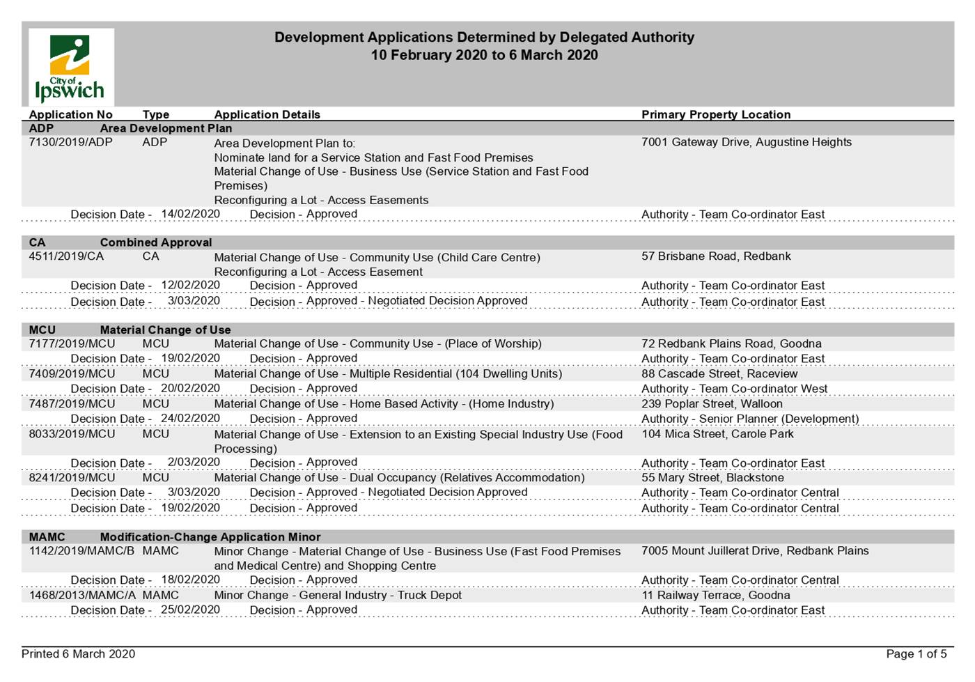
|
Growth
and Infrastructure Committee
Meeting
Agenda
|
17 March
2020
|
Doc ID No: A5892032
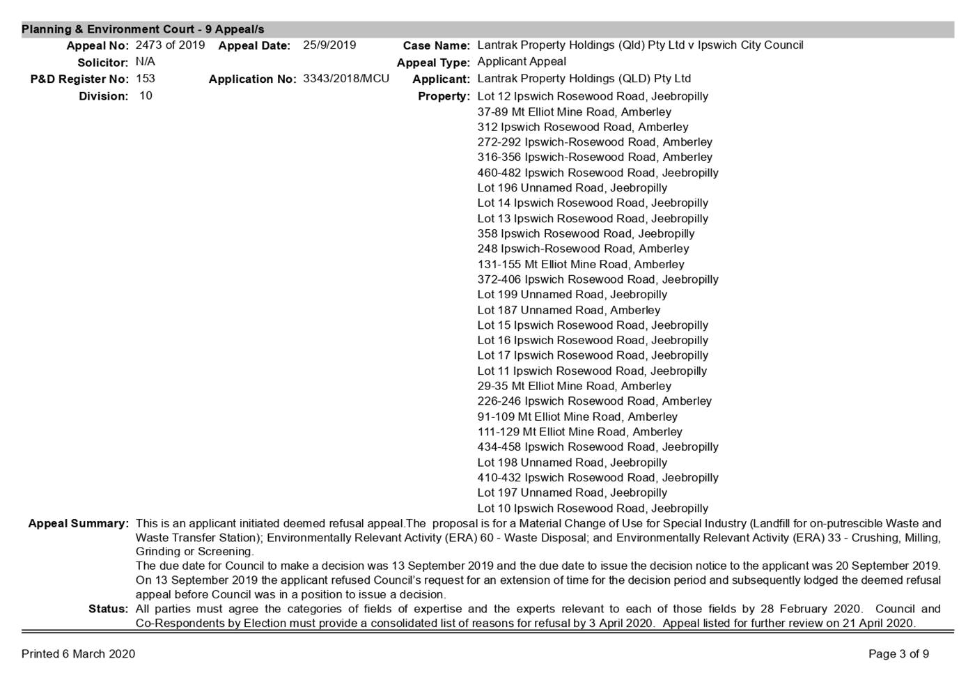
ITEM: 3
SUBJECT: Redbank Plains Road Upgrade Corridor Plan -
Stage 4
AUTHOR: Senior Engineer (Transport Planning)
DATE: 2 March 2020
Executive Summary
This is a report concerning the
outcomes of a corridor planning study for the upgrade of Redbank Plains Road
between the Cunningham Highway and Collingwood Drive (Stage 4).
Recommendation/s
That the Interim Administrator
of Ipswich City Council resolve:
A. That
the preferred alignment and configuration of the Redbank Plains Road Stage 4A
and Stage 4B Upgrade, as outlined in the report by the Senior Engineer
(Transport Planning) dated 2 March 2020, be adopted and be used to inform
future detailed design activities.
B. That
the footprint of the adopted alignment and configuration of the Redbank Plains
Road Stage 4A and Stage 4B Upgrade (refer Recommendation 1 above) be protected
through Council’s strategic corridor preservation, tactical property
acquisition and development assessment activities.
C. That
the properties identified in the report by the Senior Engineer (Transport
Planning) dated 2 March 2020 as being impacted by the footprint of the adopted
alignment and configuration of the Redbank Plains Road Stage 4A and Stage 4B
Upgrade (refer Recommendation 1 above) be flagged as an interest to Council for
future strategic road purposes in Council’s property database.
D. That
the ‘order of cost’ identified in the report by the Senior Engineer
(Transport Planning) dated 2 March 2020 for the preferred alignment and
configuration of the Redbank Plains Road Stage 4A Upgrade (refer Recommendation
1 above) be noted and considered for future investment programming activities.
E. That
an appropriate communication strategy be developed and implemented for Redbank
Plains Road Stage 4A Upgrade as the project progresses through the detailed
design process.
RELATED PARTIES
Due to the confidential nature of this information, the
related parties to the project are contained in Confidential Attachment 1.
There was no declaration of conflicts of interest by
the project team.
Advance Ipswich Theme
Managing growth and delivering key
infrastructure
Purpose of Report/Background
Strategic Context
The City of Ipswich Transport
Plan (iGO) is Council’s masterplan for Ipswich’s transport
future. To meet the vision and objectives of iGO, aspirational mode share
targets have been set and a list of actions for each element of the transport
system provided. One such action for the road network is, “R2:
Continue to undertake corridor planning studies to investigate and determine
the need, route, configuration, footprint, engineering and environmental
feasibility and costings of the road network development projects outlined in
iGO.”
Redbank Plains Road is a
strategically important arterial road between the Cunningham Highway and
Ipswich Motorway, which links the Ipswich CBD to Redbank Plains, Springfield
and Goodna (refer Figure 1). To accommodate the forecast population and
employment growth in the area, iGO (Map 8 and 9) identify the need for Redbank
Plains Road to be upgraded for road capacity, connectivity and safety purposes.
Figure
1 – Excerpt from iGO Map 8 – Road Capacity and Connectivity Map
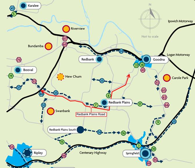
* All route alignments and configurations shown are subject to future
investigation and corridor planning.
Council has been progressively
planning and implementing the upgrade of Redbank Plains Road in stages.
Stages 1 and 2 between School Road and Keidges Road have been completed, including
the major intersection upgrade at Redbank Plains Road and Collingwood
Drive. Stage 3 from Keidges Road to Kruger Parade is currently in
detailed design, with early work anticipated to commence in the 2020-2021
financial year. Stage 4 of the Redbank Plains Road Upgrade extends from the
Cunningham Highway to Collingwood Drive as shown in Figure 2.
Figure
2 – Redbank Plains Road Stage 4 Corridor Planning Study Location
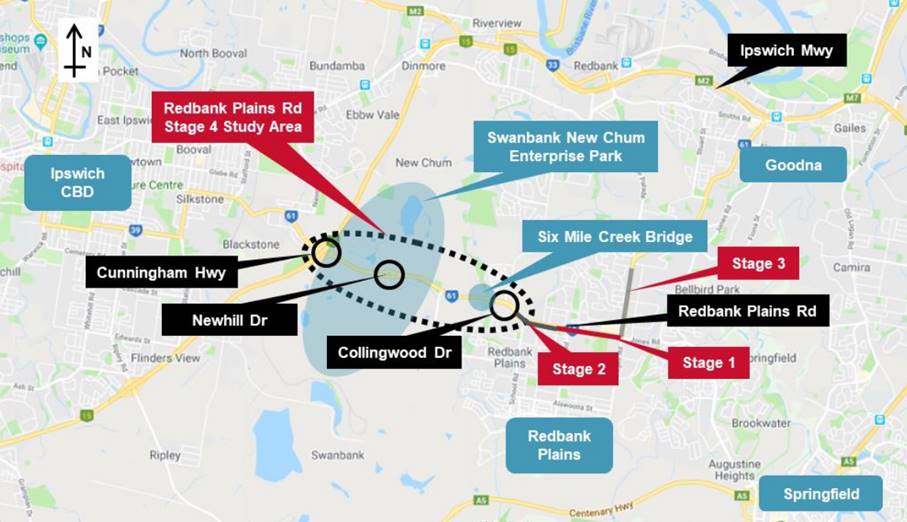
It must be noted that the extents
of Redbank Plains Road Stage 4 also form part of a future ‘strategic bus
corridor’ in iGO and part of a ‘principal cycle route’
outlined in iGO, the iGO Active Transport Action Plan (ATAP) and
Queensland Government’s Principal Cycle Network Plan (SEQ PCNP).
The section of Redbank Plains Road between the Cunningham Highway and Newhill
Drive also forms a secondary freight route as it serves as the freight access
from the Cunningham Highway into the developing Swanbank New Chum Enterprise
Park.
Scope
The purpose of the Redbank Plains
Road Stage 4 Corridor Planning Study was to determine the future corridor
footprint and the construction order of cost for an ‘interim’ road
upgrade of Redbank Plains Road to a four lane urban standard from the
Cunningham Highway to Collingwood Drive (referred to as Stage 4A) and a longer
term ‘ultimate’ road upgrade to six lanes from the Cunningham
Highway to Newhill Drive (referred to as Stage 4B). However, it must be noted
that the primary focus of the study was on Stage 4A as Stage 4B is considered a
longer term requirement beyond the 10 year capital portfolio.
The detailed scope of the Redbank
Plains Road Stage 4 Corridor Planning Study is outlined in Table 1.
Table
1 – Redbank Plains Road Stage 4 Corridor Planning Study Scope
|
ELEMENT
|
DESCRIPTION
|
|
Length
|
3.4km
|
|
Function
|
Duplication of
an Arterial Road
|
|
Connectivity
|
To provide a strategic road
link between the Cunningham Highway and Collingwood Drive which meets current
design standards and caters for the projected general traffic, public
transport and active transport demands. Freight access is also to be catered
for between the Cunningham Highway and Newhill Drive.
|
|
Geometric Design Speed
|
80km/h
|
|
Target Posted Speed Limit
|
70 km/h
|
|
Configuration
|
· Stage 4A = Interim = Provide a four lane arterial
road from the Cunningham Highway to Collingwood Drive, including the duplication
of the existing Six Mile Creek Bridge (for construction in the medium term 5
to 10 years)
· Stage 4B = Ultimate = Longer term upgrade to provide
six lanes from the Cunningham Highway to Newhill Drive, including a four-lane
grade separation of Redbank Plains Road over the Newhill Drive roundabout
(for longer term preservation, 10+ year)
|
|
Study Tasks
|
• Undertake a desktop review of existing information
and previous studies
• Assess physical conditions to identify existing land
use, transport networks, transport facilities and infrastructure
• Undertake a high level qualitative assessment of
potential alignment options
• Undertake a detailed assessment of short-listed
alignment options
• Hold a workshop with Council stakeholders to validate
the option assessment and agree on a preferred option for Stage 4A and Stage
4B
• Develop a concept design for the preferred option for
Stage 4A and Stage 4B
• Identify impacts and develop an order of cost
estimate for Stage 4A and Stage 4B
|
Options Analysis
The option development process
comprised:
· Identifying fixed
points and constraints;
· Identifying option
groups and locations;
· Undertaking an
option assessment; and
· Holding a Council
stakeholder workshop and post workshop discussions to determine a preferred
option for both Stage 4A and Stage 4B.
However, compared to typical
greenfield route planning studies, there were no fundamental differences with
route alternatives along the corridor as the project objective was to develop a
duplicated carriageway along the full length. Therefore, a qualitative
assessment was also undertaken with consideration of the following attributes:
· Provision of safe
access along and across the route for all modes;
· Encouraging safe
active transport trips along the route;
· Infrastructure
costs;
· Property impacts;
and
· Engineering and
construction feasibility.
Given the 3.4km length of the
study area, the project objectives differ along the corridor, with the varying
adjacent land use environments. To assist with the options assessment
process, the project was divided into the following three sections (refer
Figure 3).
· Section 1 –
Cunningham Highway to Newhill Drive;
· Section 2 –
Newhill Drive to Storey Street; and
· Section 3 –
Storey Street to Collingwood Drive.
Figure
3 – Redbank Plains Road Upgrade Stage 4 Project Sections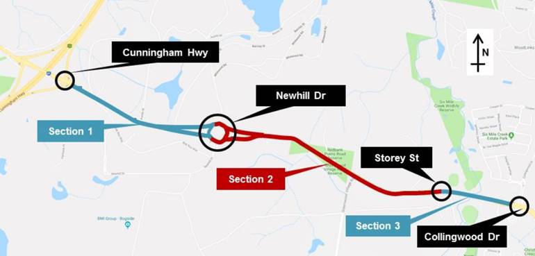
The results of the options
assessment for each project section and justification for the preferred
alignment and layout overall is provided in Confidential Attachment 2.
Preferred Option – Stage
4A - Interim
A summary of the key features of
the identified preferred alignment and layout for Redbank Plains Road Upgrade
Stage 4A (Interim), based on the options analysis method identified above, is
summarised below and illustrated on the concept plans provided in Confidential
Attachment 3:
General features:
· Two 3.5m wide
lanes for both carriageways;
· 2.0m wide sealed
outer shoulder for both carriageways between the Cunningham Highway and
Greenwood Village Road;
· 1.0m wide sealed
median shoulder for both carriageways between the Cunningham Highway and
Newhill Drive;
· 3.0m wide asphalt
cycle track on the northern side of Redbank Plains Road between the Cunningham
Highway and Greenwood Village Road, including at-grade crossings at Austin
Street and the Newhill Drive roundabout;
· 2.25m wide on-road
cycle lane for both carriageways between Greenwood Village Road and Collingwood
Drive;
· Realignment and
upgrade of the existing priority-controlled Greenwood Village Road intersection
to traffic signals;
· Traffic signals at
the proposed intersection with a primary access road to a proposed residential
development located at 639 Redbank Plains Road; and
· A new two-lane
bridge across Six Mile Creek for the westbound carriageway (ie. duplication of
the existing bridge structure).
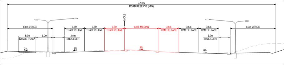
Section 1 – Cunningham
Highway to Newhill Drive:
· Given the
uncertainty regarding the timing and future investment in the upgrade of the
Cunningham Highway Interchange by the State Government, Stage 4A has been
designed to integrate with the existing highway interchange;
· Allows room for
future widening for 6 lanes into the wide centre median by setting the outside
sealed shoulder, kerb and channel and cycle track in their final positions;
· Retains the
existing road for the eastbound carriageway, due to relatively new construction
(circa 2009) and the condition of the existing infrastructure;
· Provides a new
westbound carriageway to the south of the existing road;
· Provides kerb and
channel on the outside shoulders in the final position for the Stage 4B layout,
resulting in a 13.0m wide median including inside shoulders;
· Enables the Stage
4B Newhill Drive roundabout bridge to be constructed without altering the
carriageway and ramp layouts to and from the Newhill Drive roundabout;
· Widens the
westbound departure carriageway from the Newhill Drive roundabout to two lanes
and realigns the existing left-turn slip and auxiliary lane from Newhill Drive;
· Restricts the
Austin Street intersection to left in / left out access; and
· Provides a 3.0m
wide asphalt cycle track on the northern side of Redbank Plains Road (refer
Figure 4).
Figure 4 –
Section 1 - Typical Cross Section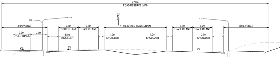
Section 2 – Newhill Drive to
Storey Street:
· The Stage 4A
layout between Newhill Drive and Storey Street comprises a new horizontal and
vertical alignment for both carriageways to address the existing sub-standard
geometry.
· Includes a
signalised ‘T’ intersection at Greenwood Village Road, with the
intersection alignment shifted approximately 40m to the south, to achieve
geometric design standards, reduce earthworks, minimise impacts to existing
significant utility services and to reduce impacts to the proposed development
at 639 Redbank Plains Road.
· Includes a
signalised ‘T’ intersection at the proposed development access for
639 Redbank Plains Road.
· Includes a 3.0m
wide asphalt cycle track on the northern side of Redbank Plains Road to the
west of Greenwood Village Road and 2.5m shared pathways and 2.25m on road cycle
lanes on the northern and southern side of Redbank Plains Road east of
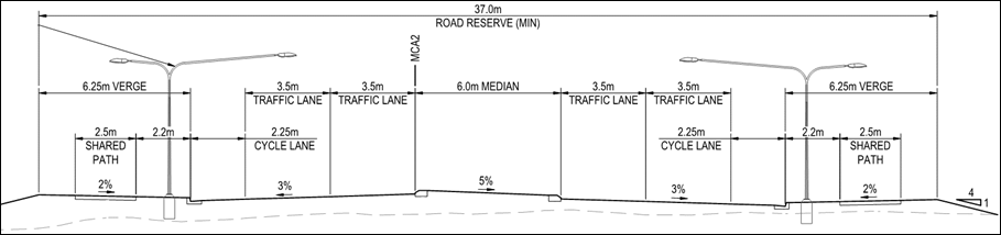
Greenwood Village Road (refer Figure 5).
Figure 5 –
Section 2 - Typical Cross Section
Section 3 – Storey Street to
Collingwood Drive:
· The Stage 4A
layout between Storey Street and Collingwood Drive follows the horizontal and
vertical alignment for the existing road.
· There are limited
works for the eastbound carriageway to tie the road and shared path into the
existing Six Mile Creek Bridge. Line marking alterations are required on the
existing bridge to reallocate the on-road cycle lane from the southern to the
northern side.
· The existing Six
Mile Creek Bridge will be duplicated to the south to facilitate the new western
boundary carriageway, and ties into the existing Collingwood Drive
intersection.
· Includes 2.5m
shared pathways and 2.25m on road cycle lanes on the northern and southern side
of Redbank Plains Road through to the Collingwood Drive intersection
(refer Figure 6).
Figure 6 –
Section 3 - Typical Cross Section
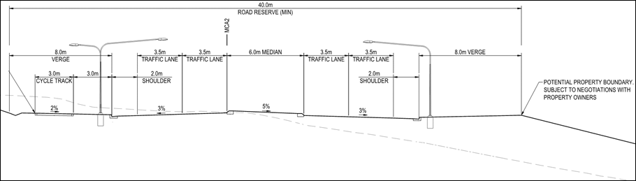
Preferred Option – Stage
4B – Ultimate – Section 1 Only
The Stage 4B (ultimate) concept
design is illustrated in Confidential Attachment 4 and upgrades the Stage 4A
layout between the Cunningham Highway and Newhill Drive with the following
general features:
· Stage 4B has been planned
to integrate with the State Government’s draft planning for the longer
term upgrade of the Cunningham Highway interchange;
· Three 3.5m wide
lanes for both carriageways between the Cunningham Highway and Newhill Drive;
· Two new two-lane
bridges for each carriageway over the Newhill Drive roundabout for through
traffic on Redbank Plains Road, with embankments and retaining walls on the
bridge approaches.
· Widens into the
Stage 4A wide central median to provide a 6 lane cross section, resulting in a
6.0m wide median to match the Redbank Plains Road alignment east of Newhill
Drive. Elements shown in red on Figure 7 demonstrate the changes from Stage 4A
to Stage 4B).
Figure 7 –
Section 3 - Typical Cross Section
Property Impacts
The concept design for the
preferred alignment for Redbank Plains Road Upgrade Stage 4A affects six
Council owned properties and nineteen other properties for either permanent or
construction only purposes (refer Confidential Attachment 5). No additional
properties are affected to facilitate the longer term Redbank Plains Road Stage
4B upgrade. Design refinement will be undertaken during further project
development and upon completion of detailed survey in order to optimise the
design and minimise impacts where possible.
Financial/RESOURCE IMPLICATIONS
Order of Cost
The project cost estimate for the
Redbank Plains Road Stage 4A upgrade will be used to inform Council’s Long
Term Financial Forecast and associated 10 Year Capital Works Portfolio.
The cost estimate has been prepared in accordance with the requirements of
TMR’s Project Cost Estimating Manual (PCEM) for an options analysis level
estimate. The risk and contingency allowance has been calculated to be
59% based on the level of maturity of the concept design. This risk and
contingency allowance falls within TMR’s typical contingency range of 40%
to 70% for projects with a maturity level similar to the project.
It should be noted that
Council’s cost estimating template would include a typical risk and
contingency allowance of 30% for this level of design. Given the
significant length of the Stage 4A upgrade (3.2km) and the ability to construct
significant portions off line from the existing roadway, it is envisaged that
there will be economies of scale and value engineering benefits that could be
realised through the future detailed design and construction phases.
Table 2 summarises the project
cost estimate for the Redbank Plains Road Stage 4A upgrade including both a 30%
and 59% risk and contingency allowance for comparison purposes. It is
proposed to use the project cost estimate including the 30% risk and
contingency allowance as per Council standard cost estimation process to inform
Council’s Long Term Financial Forecast and associated 10 Year
Capital Works Portfolio.
Table 2 – Redbank Plains
Road Stage 4A Summary Cost Estimate
|
ITEM
|
STAGE 4A COST ESTIMATE ($m)
|
|
Contractor’s
costs
|
$30.5
|
|
Principal’s
costs including property costs
|
$5.3
|
|
Property costs
component
|
$3.2
|
|
PUP costs
|
$7.8
|
|
Total base
cost
|
$46.7
|
|
Risk and
contingency allowance (%)
|
30%
|
59%
|
|
Risk and
contingency value ($m)
|
$14.0
|
$27.55
|
|
Total
risk-adjusted cost
|
$60.7
|
$74.3
|
RISK MANAGEMENT IMPLICATIONS
A project of this size and nature
will attract risks. Preliminary engineering design, hydraulic modelling,
geotechnical analysis, utility service identification, stakeholder consultation
and property impact identification appropriate to this level of transport
planning activity has been completed as part of the Redbank Plains Road Stage 4
Corridor Planning Study and several risk areas identified. The project risks
will need to be managed and mitigated where possible throughout the detailed
design and construction phases.
A summary of the key identified
risks for delivery of the Redbank Plains Road Stage 4A upgrade are as follows:
· The western
portion of the study area (Cunningham Highway to Greenwood Village Road) has
been subject to a range of former mining activities, with resulting ground
cracking previous observed within the Redbank Plains Road corridor in the
vicinity of the Newhill Drive roundabout;
· Areas adjacent to
the corridor in the vicinity of the Greenwood Village Road intersection are
designated as Matters of State Environmental Significance (MSES) under the
State Planning Policy, with State mapping identifying areas of regulated
vegetation and wildlife habitat. Desktop and visual review of area with
MSES designations do not appear to identify values that would affect the
ability to realign Redbank Plains Road, because the areas have been previously
disturbed by current and historical activities;
· The corridor
crossing two mapped waterways, being Six Mile Creek and Six Mile Creek
tributary;
· A significant
number of utility services have been identified within the existing Redbank
Plains Road corridor, which could be impacted by the future road upgrade.
The concept design has sort to avoid impacts on major utility services where
possible, however it should be acknowledged that service relocation costs are
likely to be significant component of the overall project cost. A summary
of the key known utility services within and crossing the corridor is included
in Table 3; and
· The ability for
Council to fund the delivery of the Stage 4A upgraded within Council’s Long
Term Financial Forecast and associated 10 Year Capital Works Portfolio
financial capacity.
Table 3 – Redbank Plains
Road Stage 4A Major Utility Services
|
SERVICE
|
DESCRIPTION
|
|
Communications
|
Telstra / NBN /
Optus fibre optic cables
|
|
Electricity
Underground
|
Energex LV /
11kV / 33kV
|
|
Electricity
Overhead
|
Energex /
Powerlink
|
|
Gas
|
APA 110mm high
pressure gas pipeline
|
|
Oil
|
Santos high
pressure oil pipeline (currently inactive)
|
|
Water
|
Various QUU
150mm water mains
|
|
Sewer
|
QUU sewer mains
crossing corridor
|
A summary of the key identified risks associates with not
delivering the Redbank Plains Road Stage 4A upgrade are as follows:
· The project is
identified within the City of Ipswich Transport Plan (iGO) – as a Road
Capacity Upgrade project required to service the planning population and
employment growth;
· The project is the
fourth stage of the planned Redbank Plains Road upgrade program, completing a
key 4 lane arterial road connection between the Cunningham Highway in the west,
Kruger Parade in the north and the Centenary Highway in the east (via Augusta
Parkway). Stages 1 and 2 are completed and Stage 3 is currently programmed for
construction in the 2020-2021 and 2021-2022 financial years;
· The project is
identified within Council Local Government Infrastructure Plan (LGIP) with a
forecast delivery timeframe of 2020; and
· The project is
identified as a high priority project within Council’s annual Strategic
Transport sub-program prioritisation report. The current daily traffic
volumes operating significantly over the nominal capacity for the current
standard of road, with rapid traffic growth observed (11% per annum growth) and
a significant recorded accident history over the past 5 years.
· Significant future
development within the Swanbank New Chum Enterprise is reliant on the delivery
of increased road capacity between the Cunningham Highway and Newhill Drive.
A summary of the key actions required within the next phase
of the of the Redbank Plains Road Stage 4A upgrade design are as follows:
· Undertake detailed
engineering survey and utility services field locating surveys;
· Undertake
geotechnical investigation to identify the nature and extent of subgrade;
conditions and to confirm impacts from previous mining activities along with
suitable mitigation treatments;
· Undertake an
environmental assessment to confirm impacts and mitigation treatments to
waterways, wildlife and vegetation;
· Continue
stakeholder consultation with the Department of Transport and Main Roads (TMR)
Translink and Metropolitan Region in relation to project impacts on State
interests;
· Continue stakeholder
consultation with internal Council stakeholders in relation to the creek
corridor and nearby open space facilities;
· Commence
stakeholder consultation with affected landowners;
· Further develop
the engineering design including detailed pavement design, bridge design,
retaining wall design and drainage design;
· Review the
interface between the Stage 4A concept design and the existing detailed design
for the Six Mile Creek Bridge;
· Refine horizontal
and vertical geometry including sight distance checks throughout the road
corridor; and
· Address the safety
in design risks identified in this Study, undertake a risk review process to
identify any additional risks, and document in a safety in design register.
Legal/Policy Basis
This report and its recommendations are consistent with the
policy outlined in the endorsed City of Ipswich Transport Plan 2016, the
Queensland Government South East Queensland Principal Cycle Network Plan
2016, Ipswich Planning Scheme 2006 and Local Government Infrastructure
Plan (LGIP) 2016
LGIP outlines Council’s planned trunk infrastructure
networks required to support the forecast population and employment growth for
the city. Redbank Plains Road between the Cunningham Highway and Collingwood
Drive is currently operating beyond the LGIP desired standards of service
(DSS).
There is a risk that Council will not achieve the intents
outlined in the above documents should the Redbank Plains Road Stage 4A project
not proceed in a timely manner.
COMMUNITY and OTHER CONSULTATION
This project was undertaken with
technical input provided by officers from the Infrastructure and Environment
Department (IED) and Planning and Regulatory Services Department (PRS)
including transport, civil engineering, open space, flooding, environment,
development and land use planning elements. Early consultation was also
undertaken with TMR (Metropolitan Region and Translink) in relation to the
touch points with the Cunningham Highway and the future proposed high frequency
bus route.
A strategic alignment for the
Redbank Plains Road Stage 4 Upgrade was outlined in the draft City of
Ipswich Transport Plan which underwent public consultation activities in
2015 and was endorsed by Council in 2016. The Ipswich Planning Scheme
– Policy 5 – Infrastructure and the LGIP identifies the Redbank
Plains Road Stage 4A project as a future road infrastructure project.
More detailed community
consultation will be required as part of the next project phase when funding
has been allocated and the design further refined.
Conclusion
The Redbank Plains Road Stage 4A
and 4B upgrades are identified in iGO – The City of Ipswich Transport
Plan 2016, the Ipswich Planning Scheme and the Local Government Infrastructure
Plan 2016. Stages 1 and 2 of the planned Redbank Plains Road upgrade
program have been completed and Stage 3 is programmed for construction in the
2020-2021 and 2021-2022 financial years.
The purpose of this project was to
determine the future corridor footprint and the construction order of cost for
an ‘interim’ road upgrade of Redbank Plains Road to a four lane
urban standard from the Cunningham Highway to Collingwood Drive (referred to as
Stage 4A) and a longer term ‘ultimate’ road upgrade to six lanes
from the Cunningham Highway to Newhill Drive for corridor preservation purposes
(referred to as Stage 4B).
The project has identified a
preferred alignment, configuration, corridor footprint and cost estimate for
the 3.2km Redbank Plains Road Stage 4A upgrade. The project has also
identified the preferred configuration for the longer term Redbank Plains Road
Stage 4B upgrade. The cost estimate for the Stage 4A upgrade is $60.7
million, including a 30% risk and contingency allowance ($14m). Outcomes
of the Redbank Plains Road corridor plan will form the basis for future
detailed design and construction activities and will be used to inform
Council’s development assessment and investment programming
activities.
Attachments and Confidential Background Papers
|
|
CONFIDENTIAL
|
|
1.
|
Related Parties
|
|
2.
|
Options Assessment
|
|
3.
|
Stage 4A Concept Plans
|
|
4.
|
Stage 4B Concept Plans
|
|
5.
|
Property Impacts
|
Brad Freiberg
Senior Engineer
(Transport Planning)
I concur with the recommendations contained in this
report.
Mary Torres
Infrastructure
Strategy and Planning Manager
I concur with the recommendations contained in this
report.
Tony Dileo
Manager
Infrastructure Strategy
I concur with the recommendations contained in this
report.
Charlie Dill
General Manager -
Infrastructure and Environment
“Together,
we proudly enhance the quality of life for our community”