IPSWICH
CITY
COUNCIL
AGENDA
Growth Infrastructure and Waste Committee
Thursday, 12 October 2023
9.00 am
Council Chambers, Level 8
1 Nicholas Street, Ipswich
IPSWICH
CITY
COUNCIL
AGENDA
Growth Infrastructure and Waste Committee
Thursday, 12 October 2023
9.00 am
Council Chambers, Level 8
1 Nicholas Street, Ipswich
|
MEMBERS OF THE Growth Infrastructure and Waste Committee |
|
|
Mayor Teresa Harding (Chairperson) Councillor Paul Tully (Deputy Chairperson) |
Councillor Sheila Ireland Councillor Jacob Madsen Councillor Marnie Doyle Councillor Andrew Fechner Councillor Kate Kunzelmann Deputy Mayor Russell Milligan Councillor Nicole Jonic |
|
Growth Infrastructure and Waste Committee Meeting Agenda |
12 October 2023 |
Growth Infrastructure and Waste Committee AGENDA
|
Item No. |
Item Title |
Page No. |
|
|
Welcome to Country or Acknowledgment of Country |
|
|
|
Declarations of Interest |
|
|
|
MATTERS FOR RECOMMENDATION TO COUNCIL |
|
|
|
Business Outstanding |
|
|
1 |
Response to Petition - Setting up of an Islamic section in an Ipswich cemetery |
10 |
|
|
Confirmation of Minutes |
|
|
2 |
Confirmation of Minutes of the Growth Infrastructure and Waste Committee No. 2023(08) of 5 September 2023 |
17 |
|
|
Officers’ Reports |
|
|
|
MATTERS TO BE RESOLVED UNDER DELEGATION (in accordance with section 257(1)(c) of the Local Government Act 2009, the Growth, Infrastructure and Waste Committee has been delegated power to make decisions on behalf of Council for decisions made under the Planning Act 2016 and the Economic Development Act 2012) |
|
|
3 |
Development Application Recommendation - 13198/2022/CA Combined application for Development of 48-70 and 84 Pindari Drive and 67-103 Dances Road, Thagoona for residential purposes |
25 |
|
|
MATTERS FOR RECOMMENDATION TO COUNCIL |
|
|
4 |
Proposed Submission and Housing Supply Statement on the Draft South East Queensland Regional Plan 2023 Update and Draft SEQ Infrastructure Supplement |
215 |
|
5 |
Provisional Projects Approval |
267 |
|
6 |
Public Monuments and Memorials - Assessment of Application |
271 |
|
7 |
Asset and Infrastructure Services Department Capital Delivery Report August 2023 |
289 |
|
8 |
Exercise Of Delegation Report |
314 |
|
9 |
Planning and Environment Court Action Status Report |
332 |
|
10 |
**Sub-Regional Waste Alliance - MRF Investment Decision |
340 |
|
|
Notices of Motion |
|
|
|
Matters Arising |
|
** Item includes confidential papers
Growth Infrastructure and Waste Committee NO. 9
12 October 2023
AGENDA
Welcome to Country or Acknowledgement of Country
DECLARATIONS OF INTEREST IN MATTERS ON THE AGENDA
MATTERS FOR RECOMMENDATION TO COUNCIL
BUSINESS OUTSTANDING
1. Response to Petition - Setting up of an Islamic section in an Ipswich cemetery
This is a report concerning a petition that was presented to the Council meeting of 27 July 2023 requesting investigations into the setting up of an Islamic section in an Ipswich Cemetery. The recommendation of that report was to investigate the matter and provide a report back to the relevant committee.
Recommendation
That Council Officers continue to progress the establishment of an Islamic burial section at an Ipswich City Council managed cemetery.
Confirmation of Minutes
2. Confirmation of Minutes of the Growth Infrastructure and Waste Committee No. 2023(08) of 5 September 2023
Recommendation
That the Minutes of the Meeting held on 5 September 2023 be confirmed.
Officers’ Reports
MATTERS TO BE RESOLVED UNDER DELEGATION
(in accordance with section 257(1)(c) of the Local Government Act 2009, the Growth, Infrastructure and Waste Committee has been delegated power to make decisions on behalf of Council for decisions made under the Planning Act 2016 and the Economic Development Act 2012)
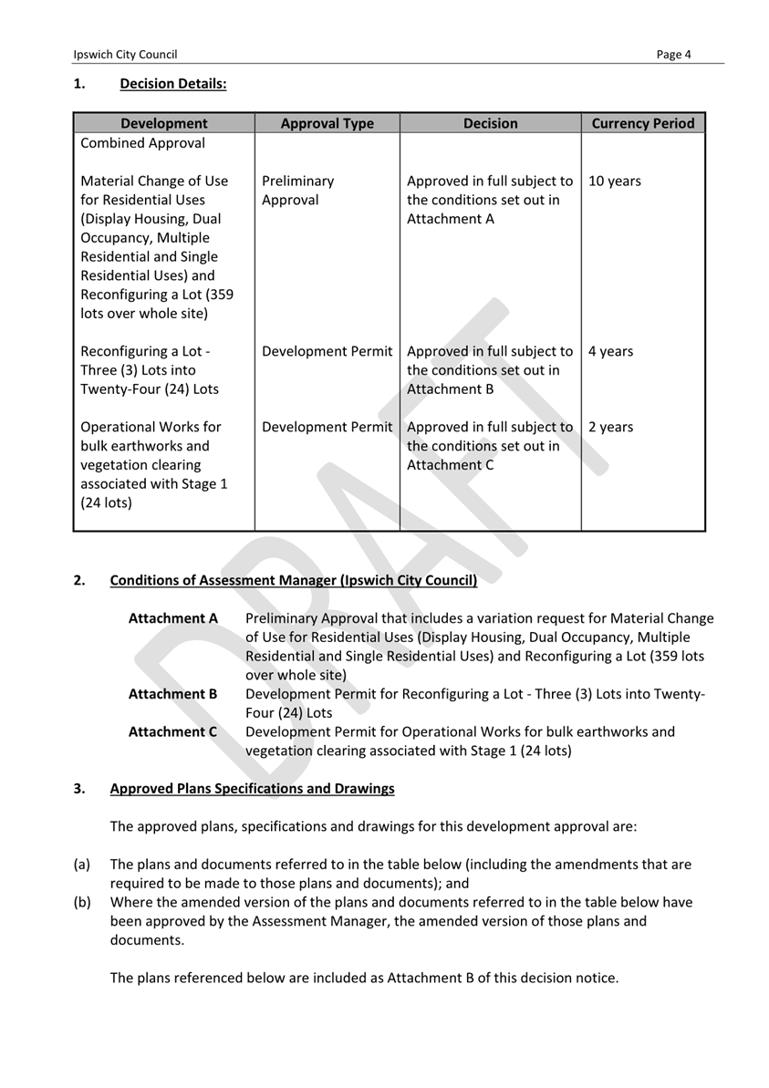
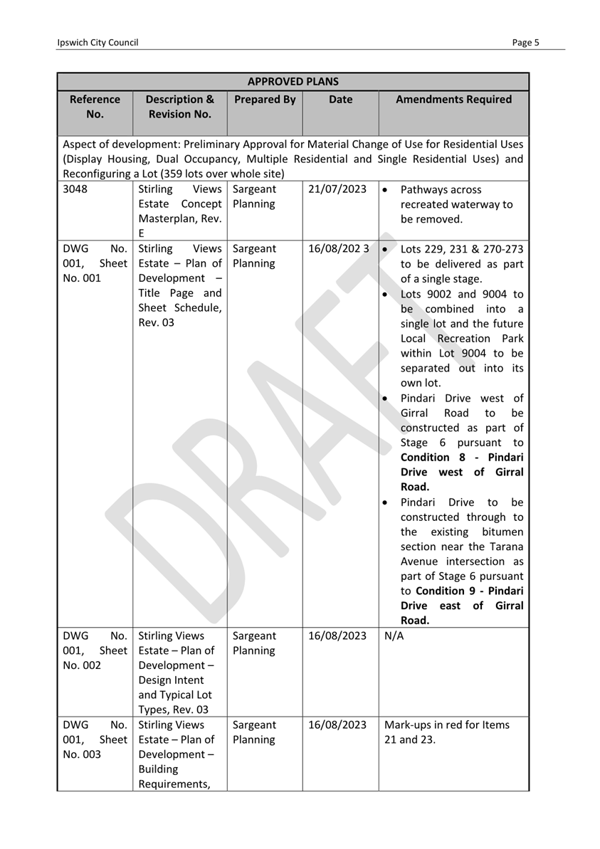
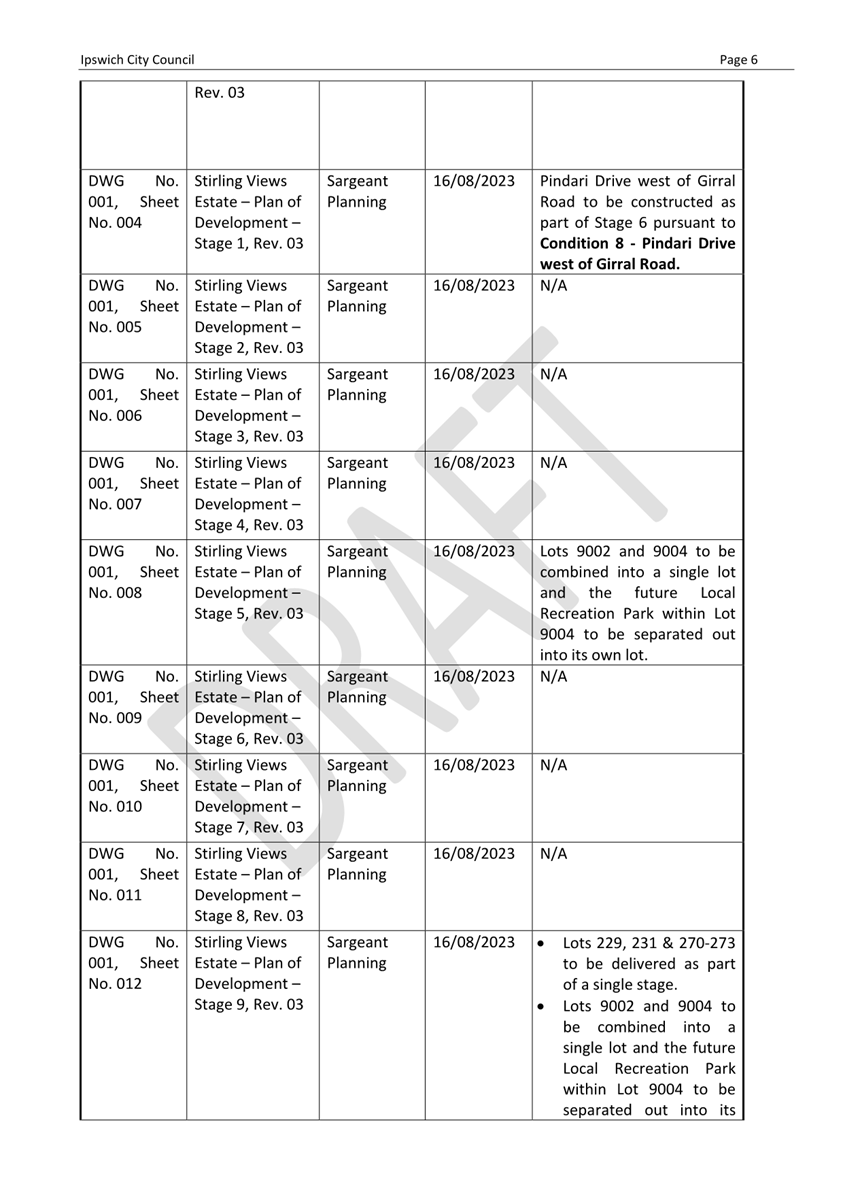
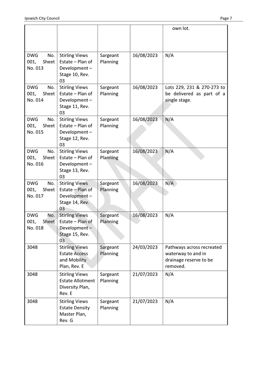
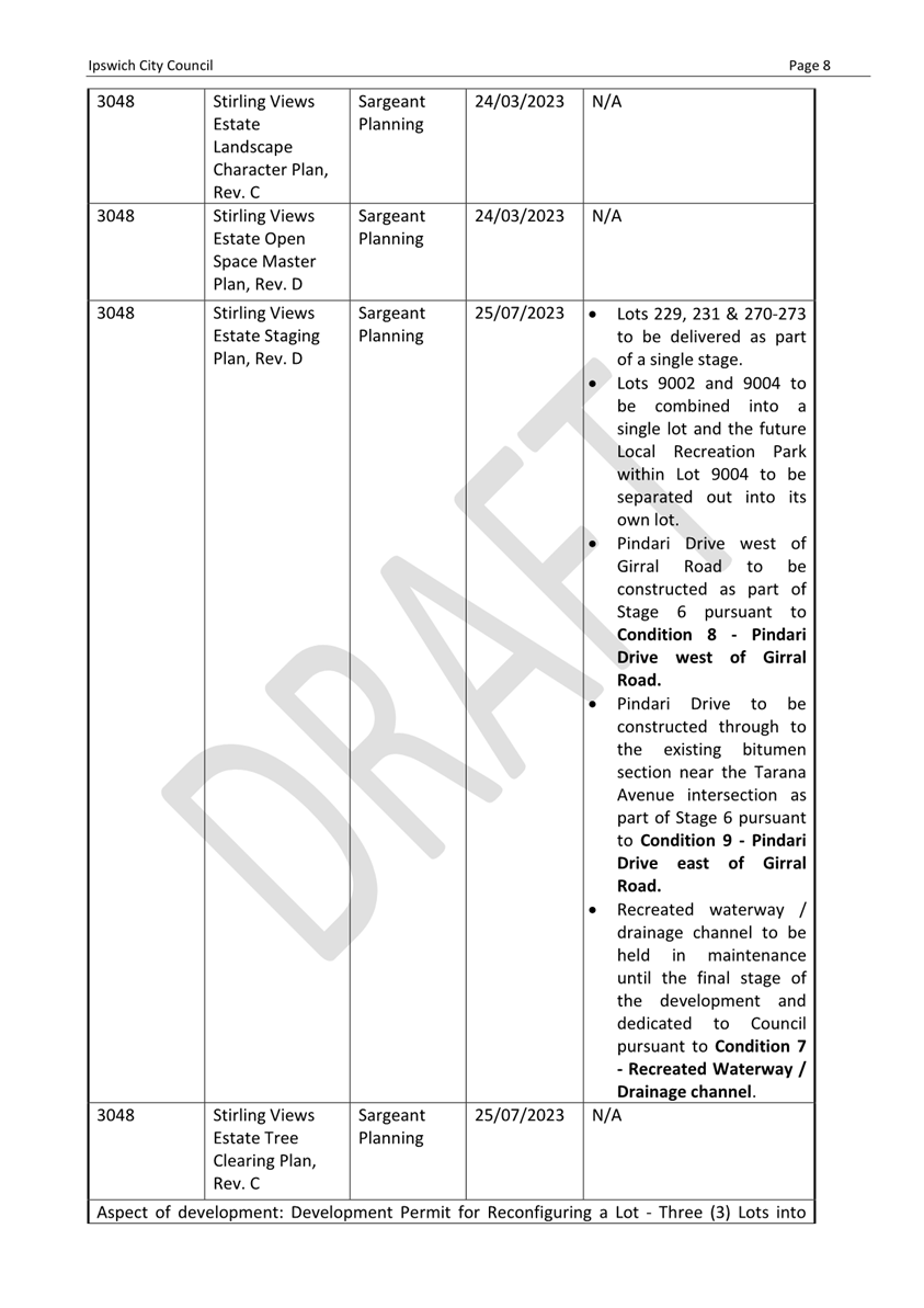
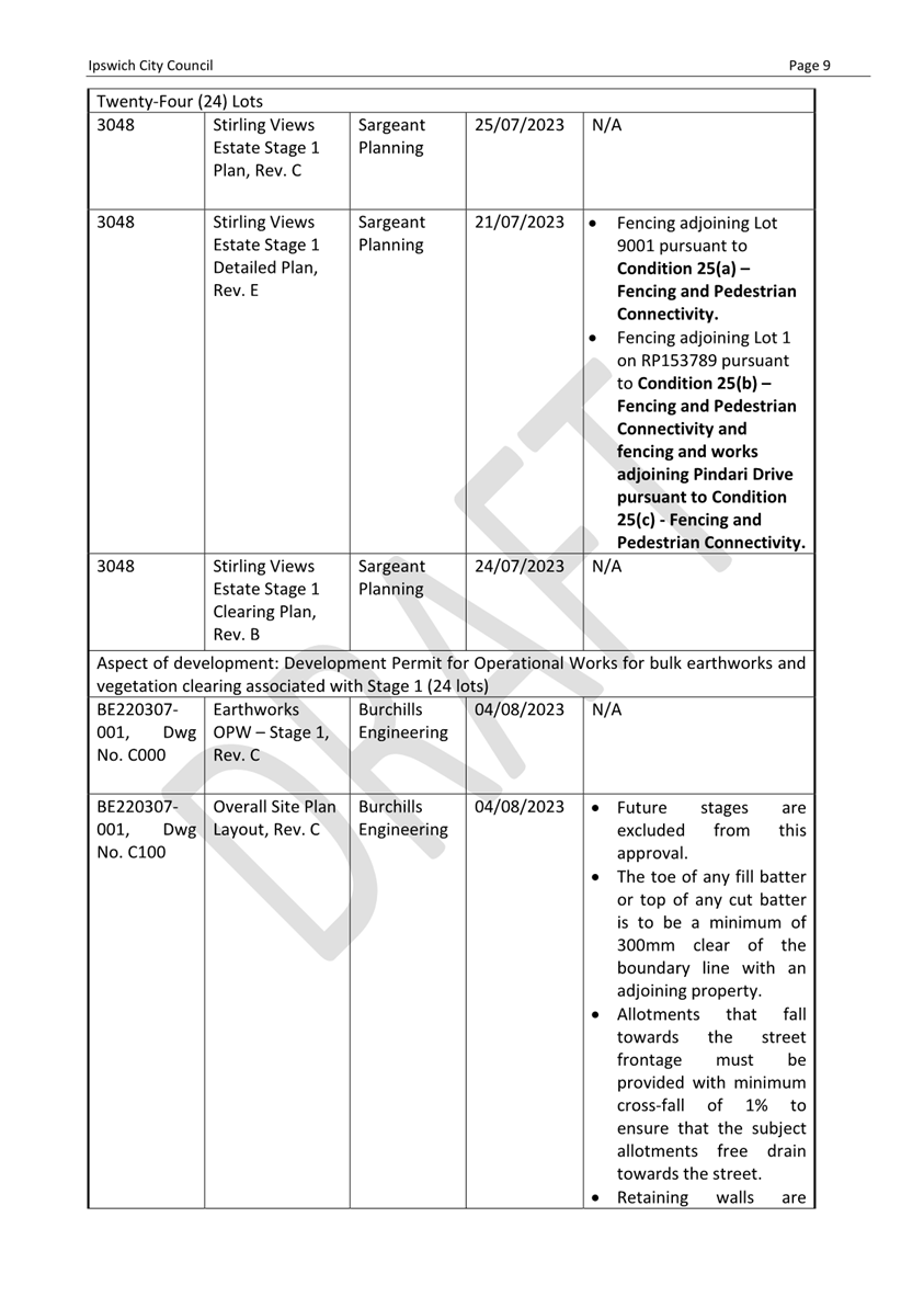
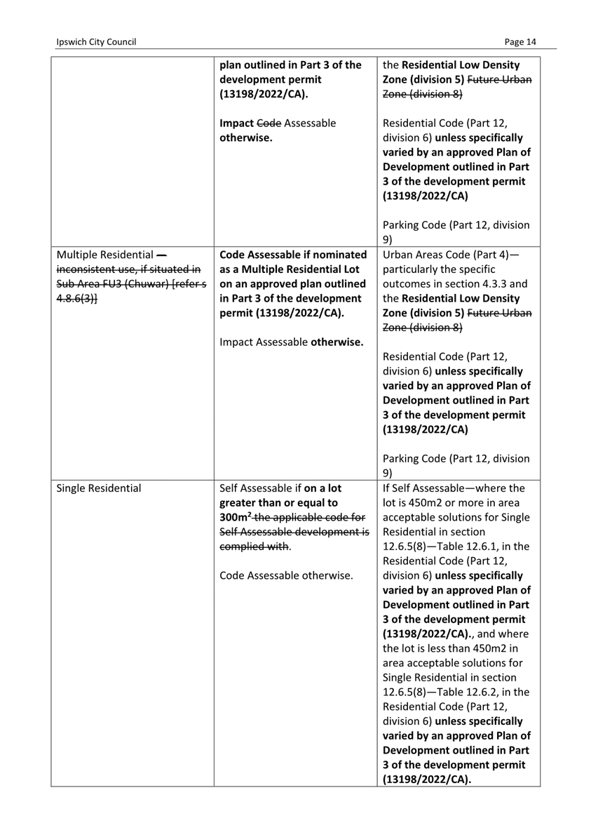
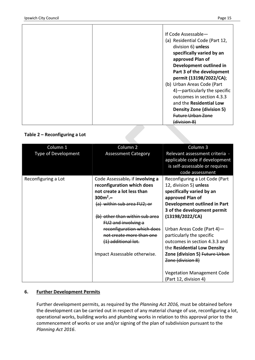
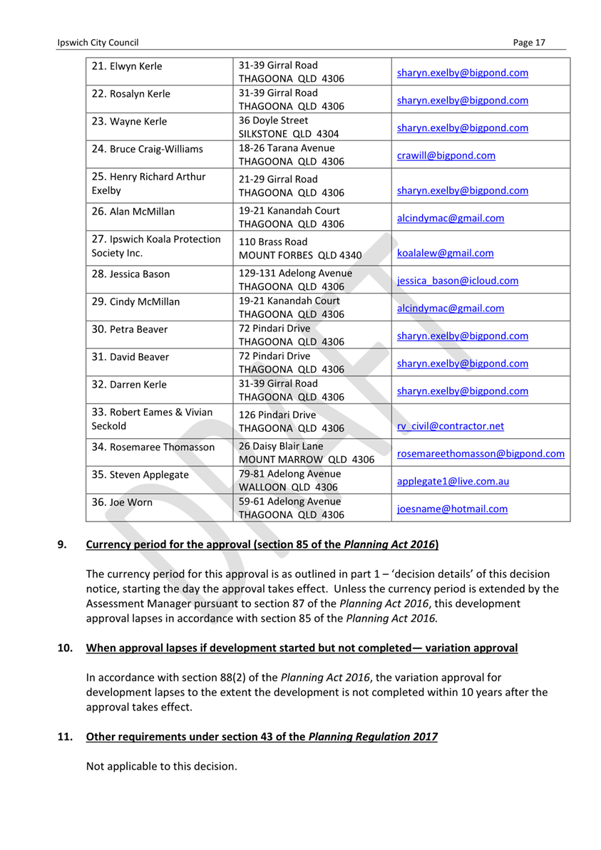
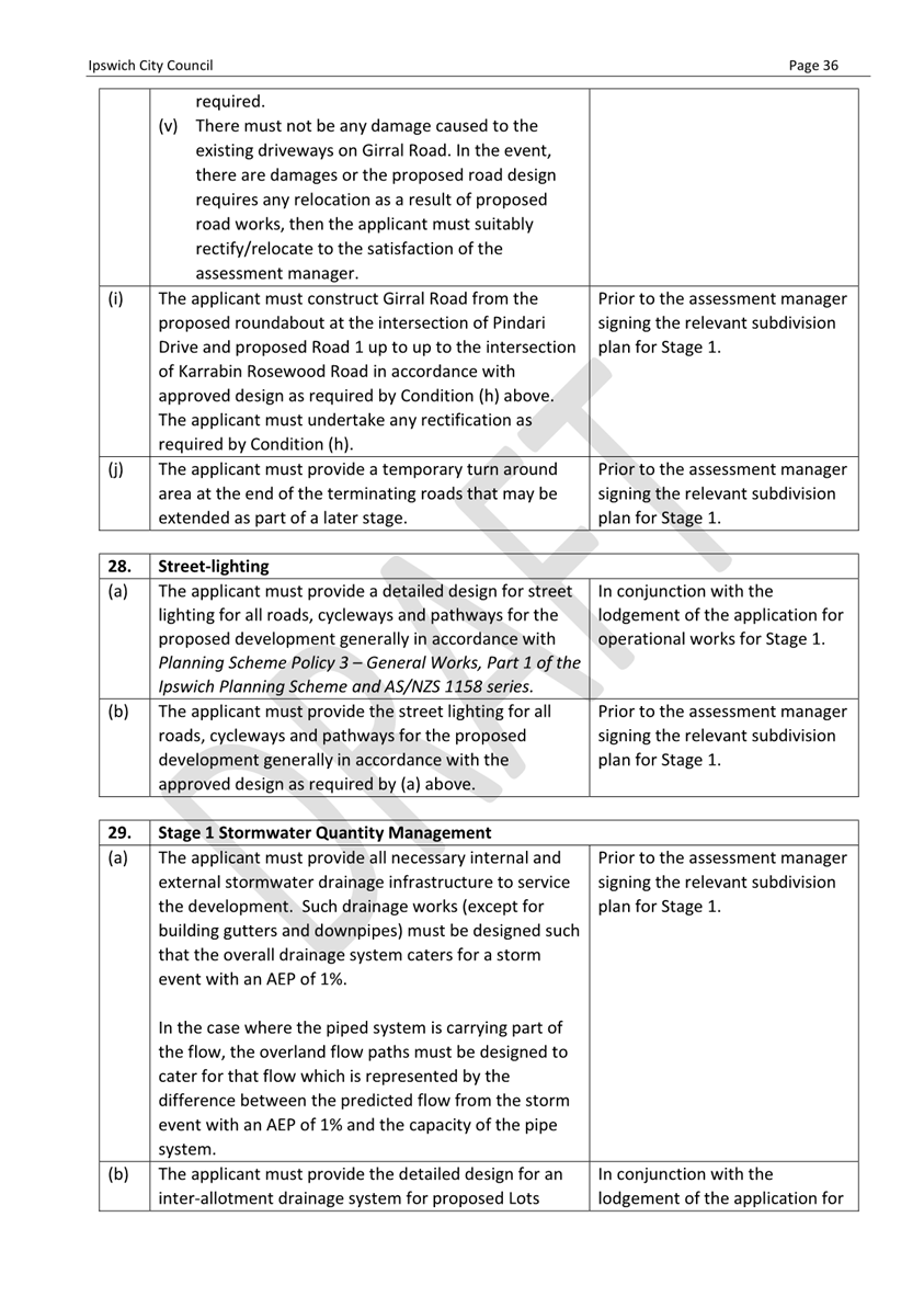
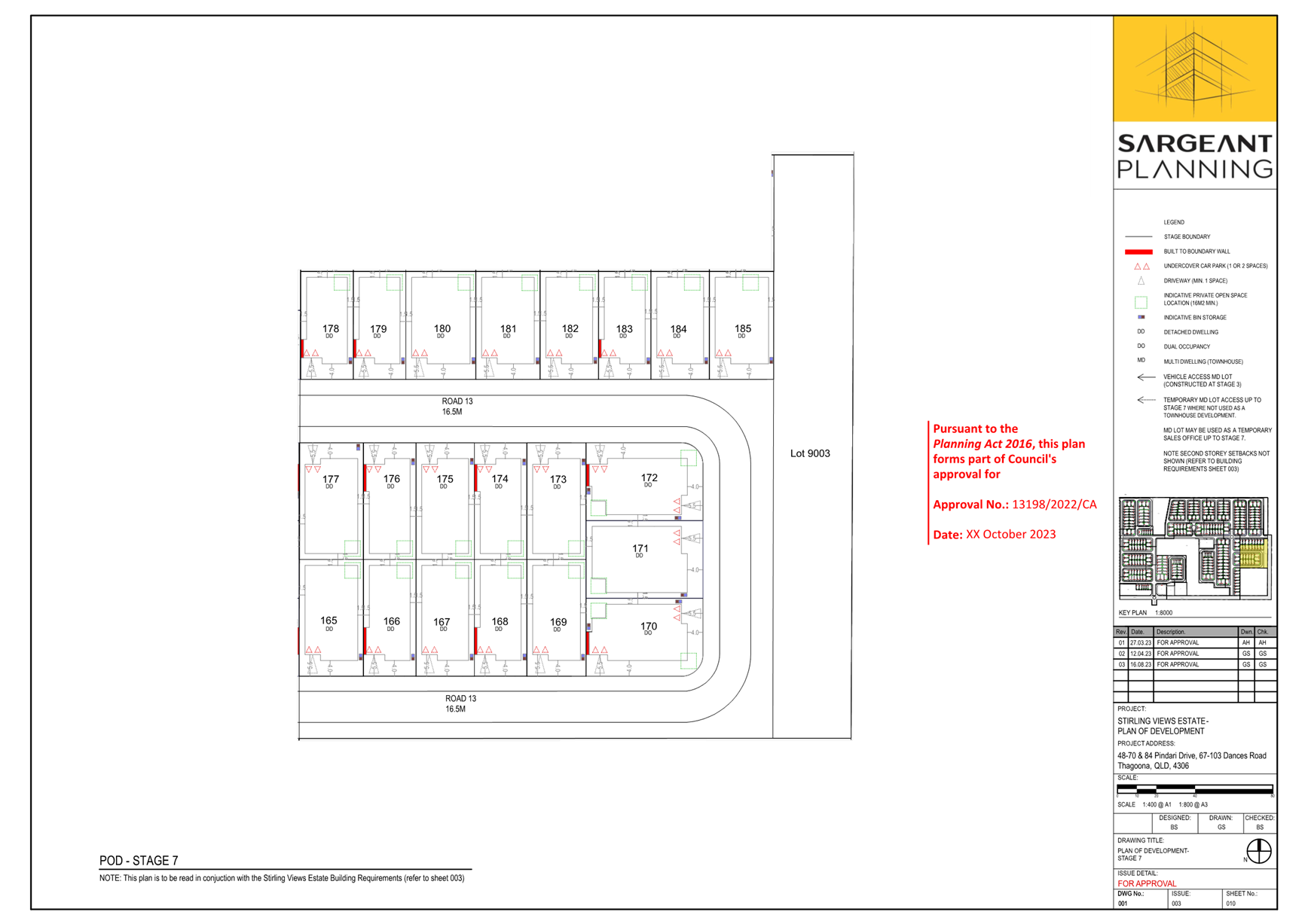
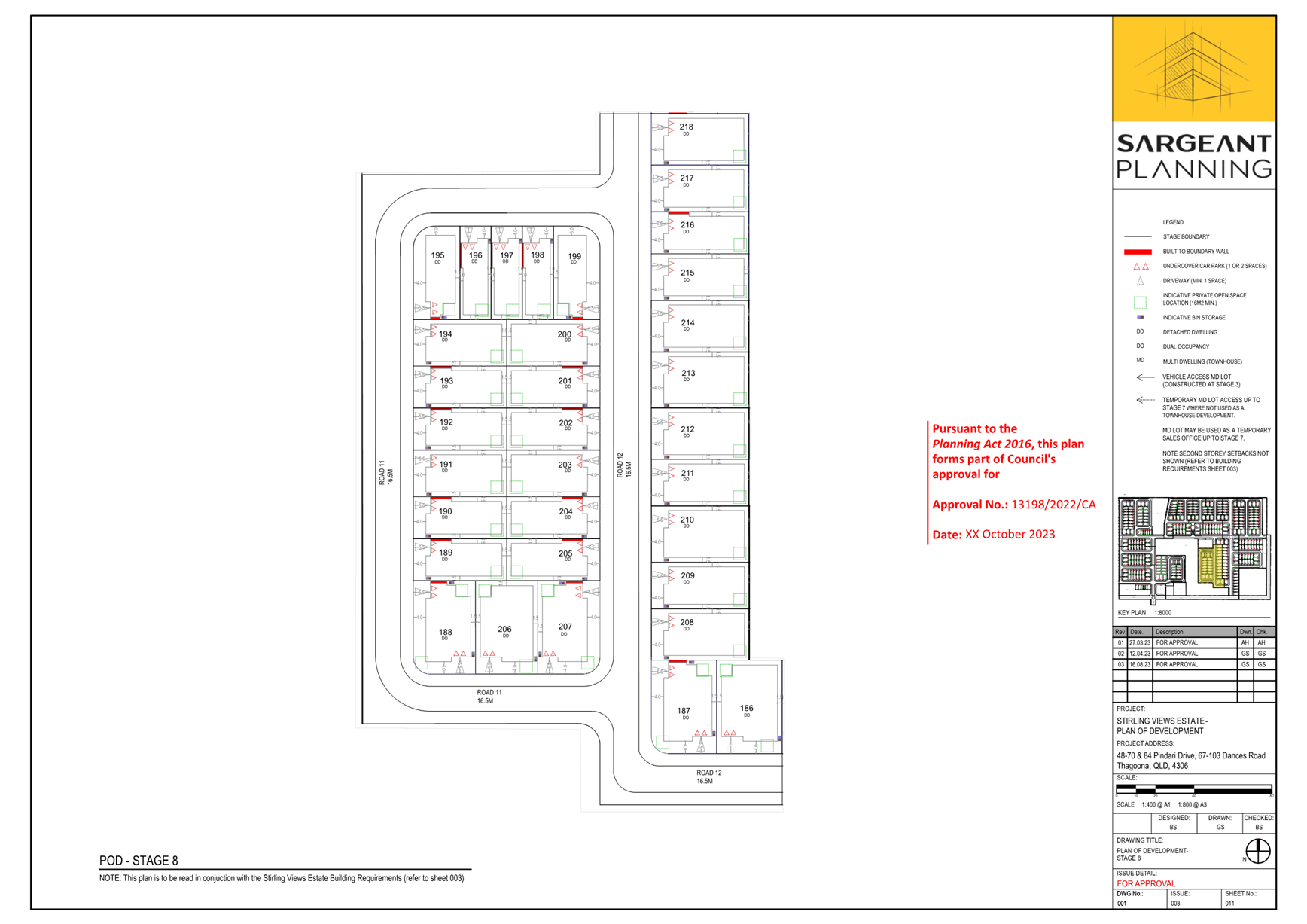
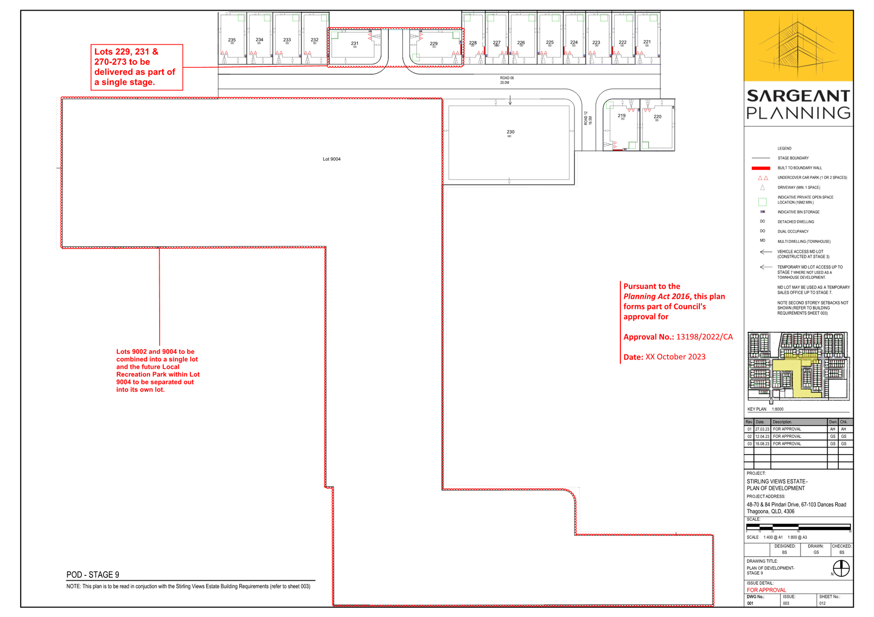
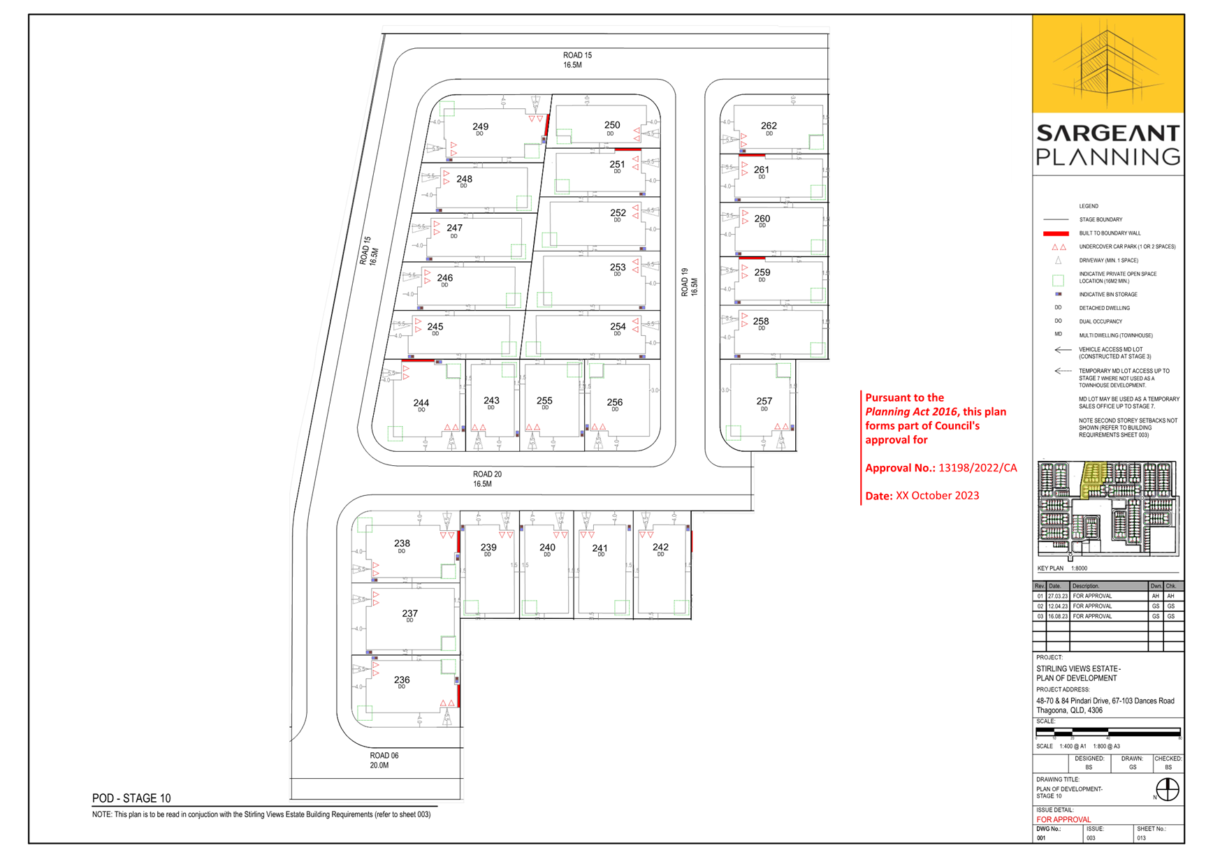
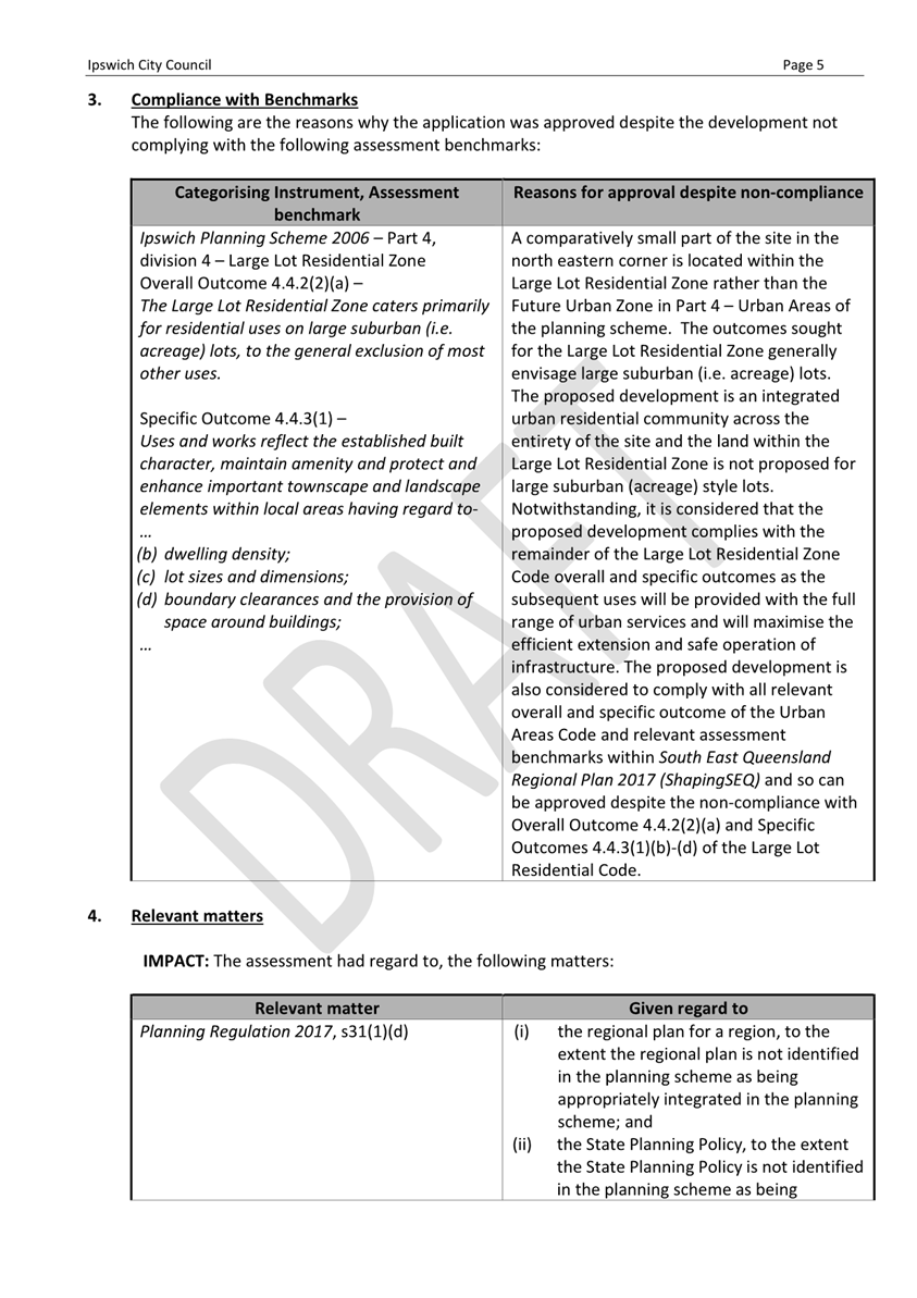
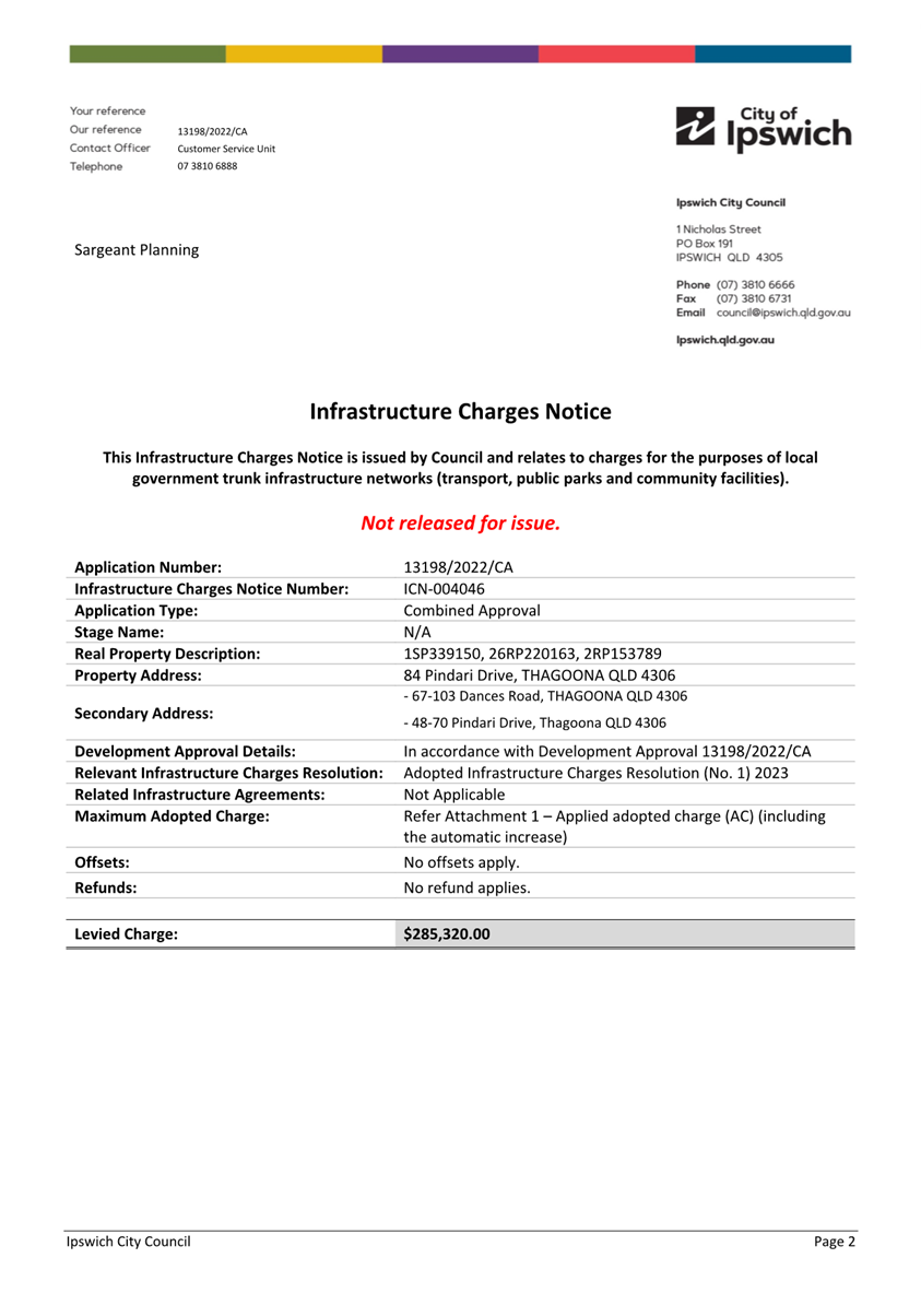
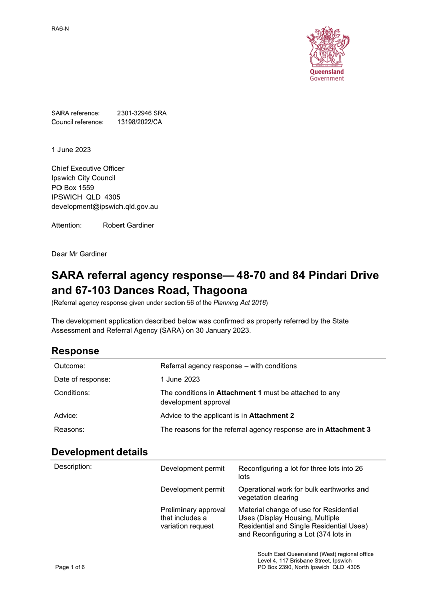
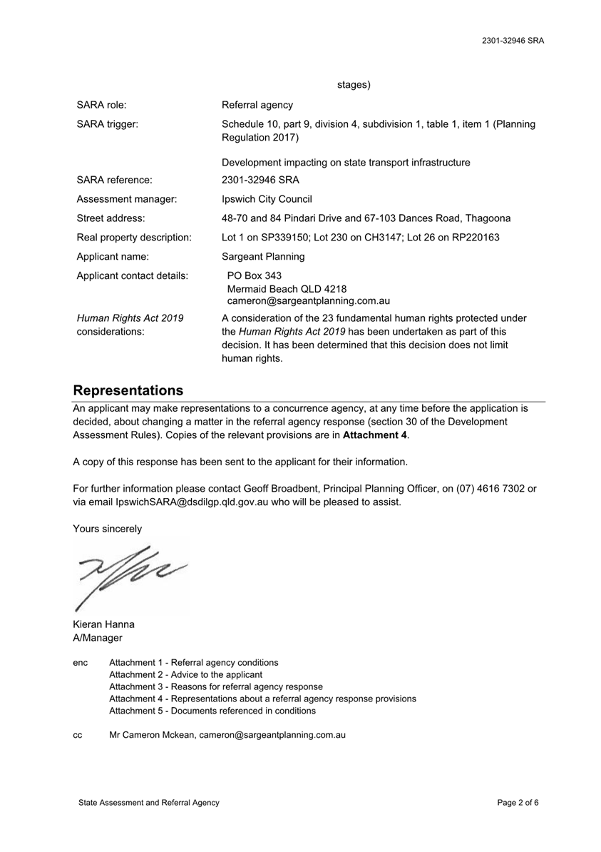
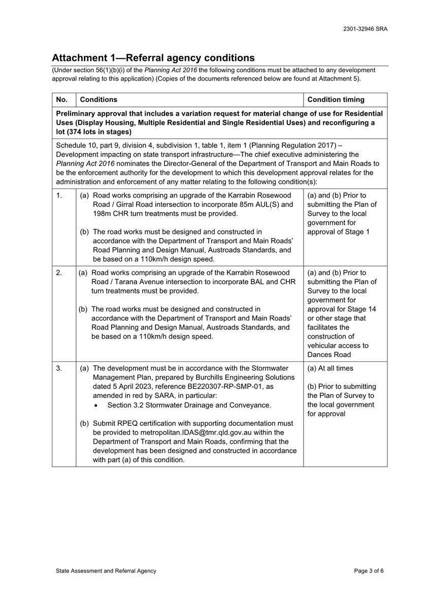
3. Development Application Recommendation - 13198/2022/CA Combined application for Development of 48-70 and 84 Pindari Drive and 67-103 Dances Road, Thagoona for residential purposes
This is a report concerning an application seeking approval for a Preliminary Approval that includes a variation request for a Material Change of Use for Residential Uses (Display Housing, Dual Occupancy, Multiple Residential and Single Residential Uses) and Reconfiguring a Lot (359 lots over whole site), a Development Permit for Reconfiguring a Lot - Three (3) Lots into Twenty-Four (24) Lots and a Development Permit for Operational Works for bulk earthworks and vegetation clearing associated with Stage 1 (24 lots) at 48-70 Pindari Drive and 84 Pindari Drive, and 67-103 Dances Road, Thagoona.
Parts of the Walloon and Thagoona areas have been planned for urban growth since 2006, with preparation of a planning study occurring between 2003 and 2005 resulting in changes to the Ipswich Planning Scheme in 2006. The ultimate plan for this area was included in the Ipswich Planning Scheme as a Land Use Concept Master Plan. The proposed development is consistent with this land use concept master plan.
The proposed development has been assessed with regard to the applicable assessment benchmarks. The proposed development generally complies with the assessment benchmarks or can be conditioned to comply as outlined below.
Recommendation
That Council approve development application no. 13198/2022/CA subject to conditions and attachments.
MATTERS FOR RECOMMENDATION TO COUNCIL
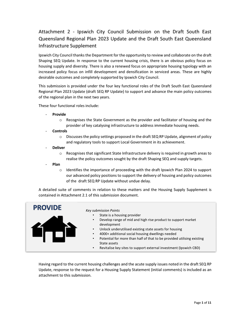
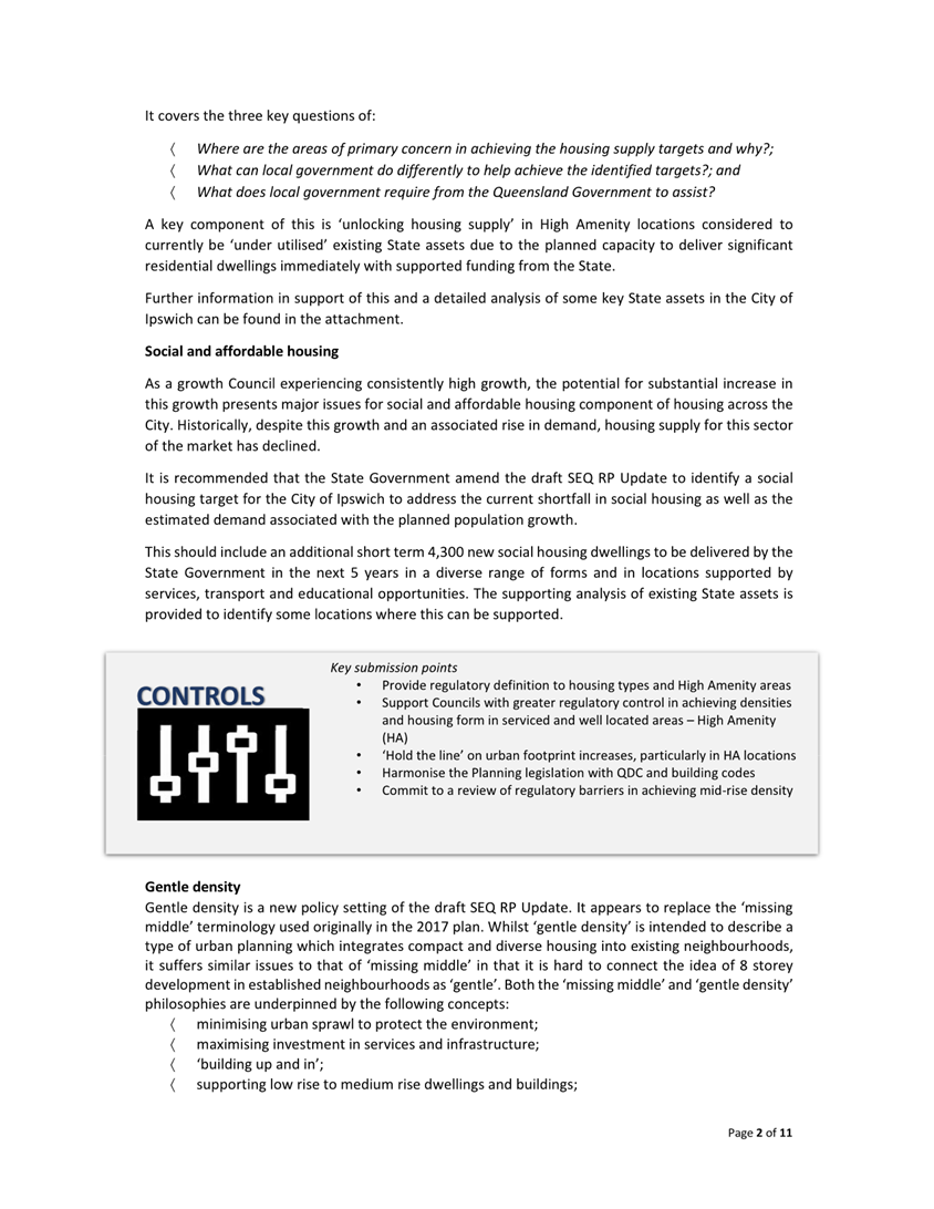
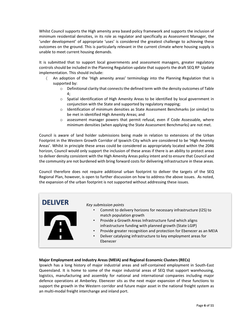
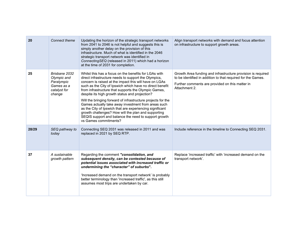
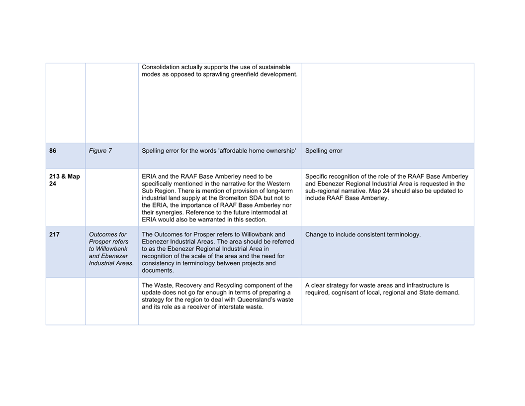
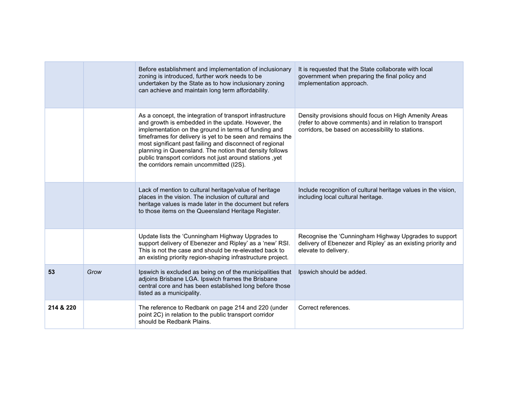
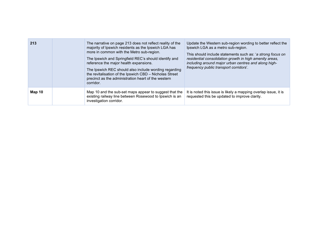
4. Proposed Submission and Housing Supply Statement on the Draft South East Queensland Regional Plan 2023 Update and Draft SEQ Infrastructure Supplement
This is a report concerning the Draft South East Queensland Regional Plan 2023 Update (Draft SEQ RP Update) and the Draft South East Queensland Infrastructure Supplement (Draft SEQIS).
It is recommended that Council make a submission on both the Draft SEQ RP Update and Draft SEQIS, and it is also recommended that Council seek:
· additional information and ongoing transparent engagement from the State Government;
· ongoing collaboration on finalising any major policy changes, include any regulatory policy changes;
· collaboration on finalising the growth targets, housing diversity targets, social and affordability targets, including any sub-targets as they relate to Ipswich, to ensure that they are fit for purpose; and
· State Government commitment to a comprehensive and urgent review of infrastructure charges.
The report also outlines the proposed initial comments intended to facilitate collaboration with the State Government on finalising a Housing Supply Statement for Ipswich.
Recommendation
A. That Council endorse the initial Housing Supply Statement comments included in Attachment 1 and submission included in Attachment 1 to be made to the Deputy Premier and Minister for State Development, Infrastructure, Local Government and Planning.
B. That Council endorse the submission on the Draft SEQ RP Update and Draft SEQIS as included in Attachment 2 to be made to the Deputy Premier and Minister for State Development, Infrastructure, Local Government and Planning.
C. That Council officers continue to liaise with the State Government during the finalisation of the Draft SEQ RP Update and Draft SEQIS and provide an update to Council upon completion.
D. That Council officers collaborate with the State Government during the finalisation of the Draft SEQ RP Update and Draft SEQIS to finalise a Housing Supply Statement and provide an update to Council for endorsement upon completion.
5. Provisional Projects Approval
This is a report seeking Council consideration of, and capital funding for, the Provisional Projects listed in this report.
The projects have been suggested by the Councillors for assessment against the Capital Investment in Provisional Projects Policy.
The projects noted in this report have been assessed by the Asset and Infrastructure Services Department and are considered consistent with the policy and are tabled for consideration by Council to progress.
Recommendation
That Council approve the Provisional Projects listed below to design and construction in accordance with the Capital Investment in Provisional Projects Policy:
1. Division 2 – Installation of pedestrian handrails at the existing pedestrian refuge located on Springfield Lakes Boulevarde, Springfield Lakes $3,000.
2. Division 2 – Extension of concrete footpath from the offstreet carpark at Bruce Lane leading to the Camira Friends and Neighbours Hall, Bruce Lane, Camira $4,000.
3. Division 2 – Installation of ‘Man Walk’ Sign within Robelle Domain, Springfield Central $1,500.
4. Division 2 – Contribution towards fitout of the mezzanine floor of the Springfield Central YMCA, Springfield Central $50,000.
5. Division 4 – Installation of dog bowl and associated plumbing at John Murphy Park, Brassall $1,500.
6. Division 4 – Installation of Community Noticeboard at Karalee located off Junction Road (near intersection of Torrens Street), Karalee $15,000.
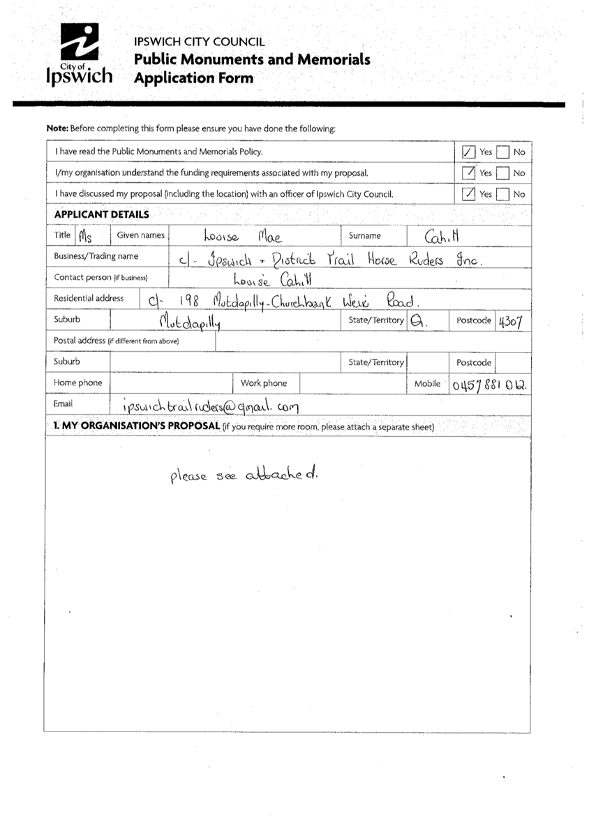
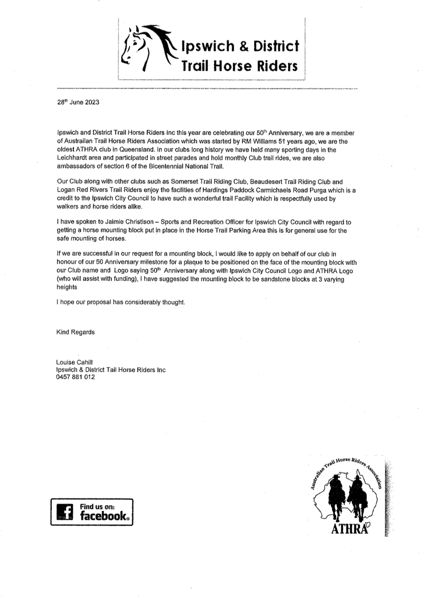
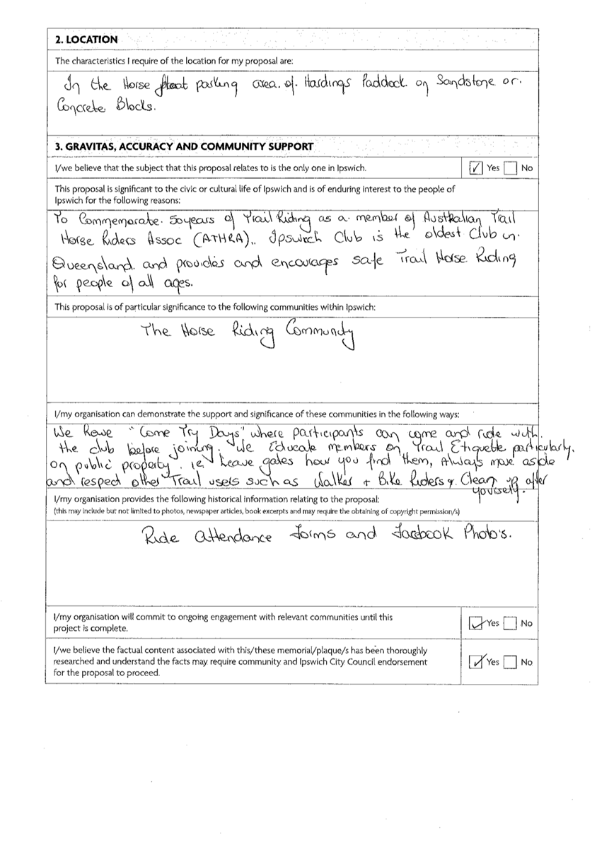
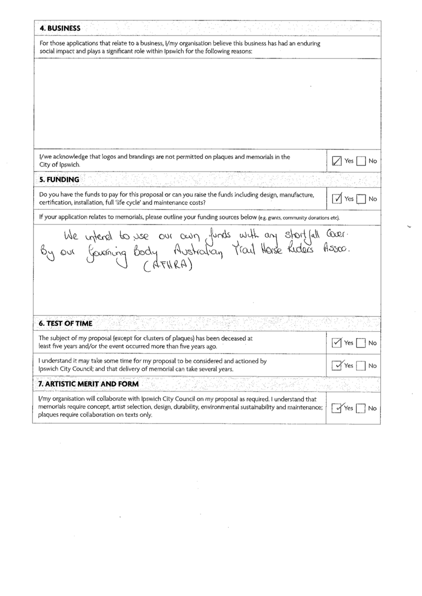
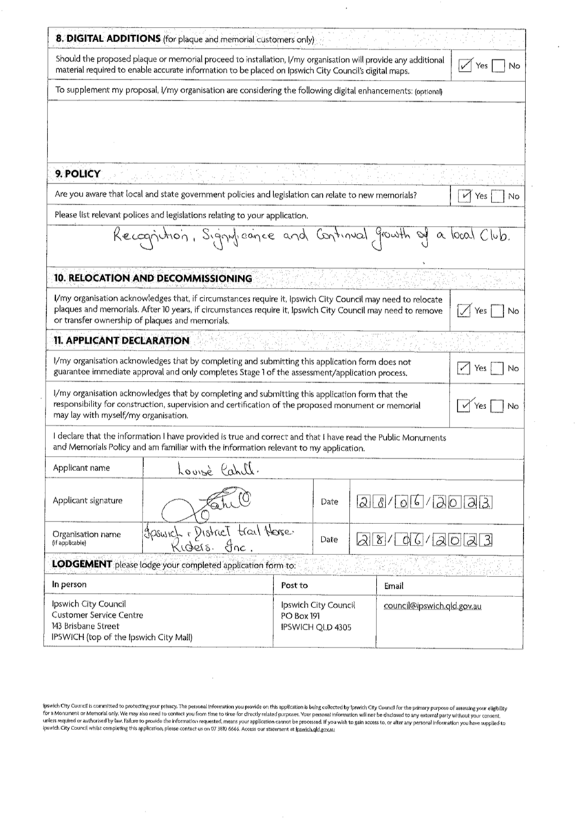
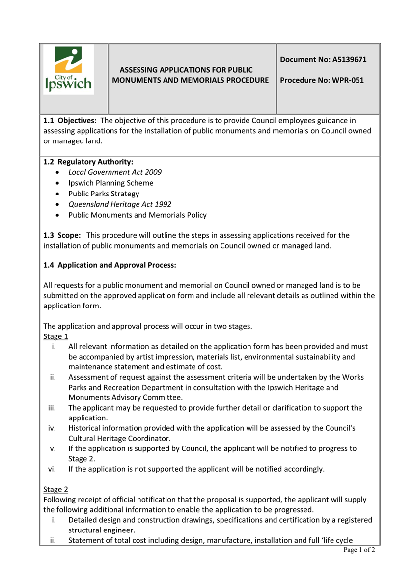
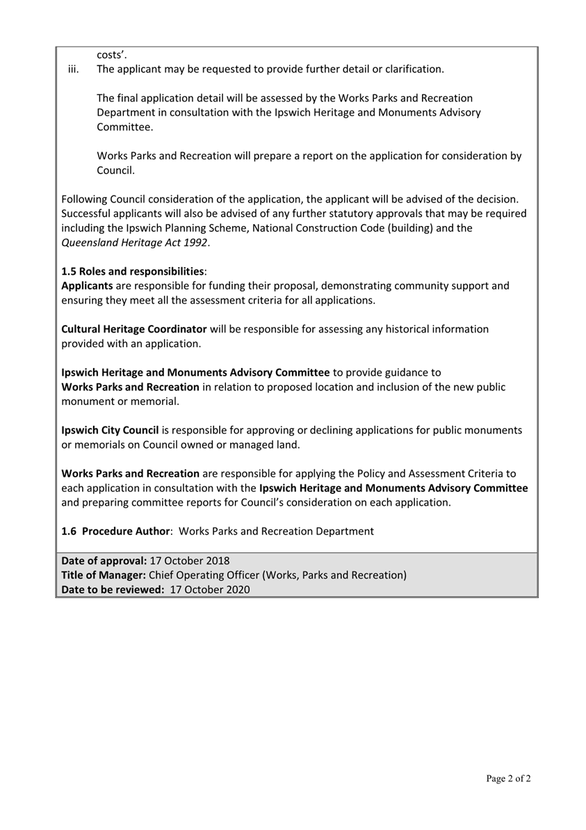
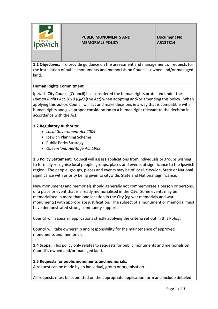
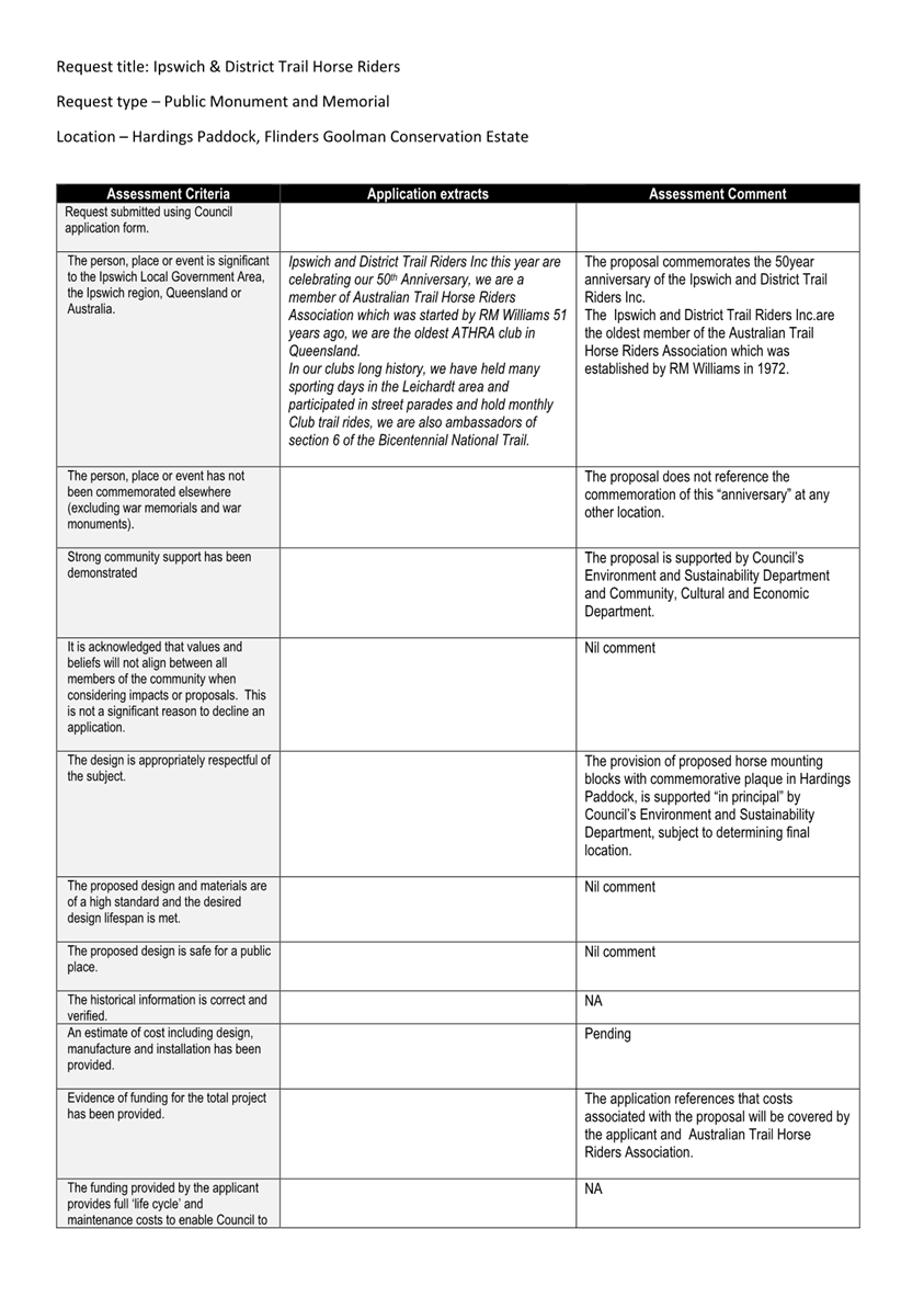
6. Public Monuments and Memorials - Assessment of Application
This is a report concerning a ‘Public Monuments and Memorials’ application which has been received by Council from Mrs Louise Cahill, President of the Ipswich and District Trail Horse Riders Inc (I&DTHR), proposing the installation of horse mounting blocks with a commemorative plaque in Harding’s Paddock (Flinders Goolman Conservation Estate) to commemorate the 50th Anniversary of the I&DTHR.
Recommendation
That the memorial as noted in the application detailed in Attachment 1, be approved by Council.
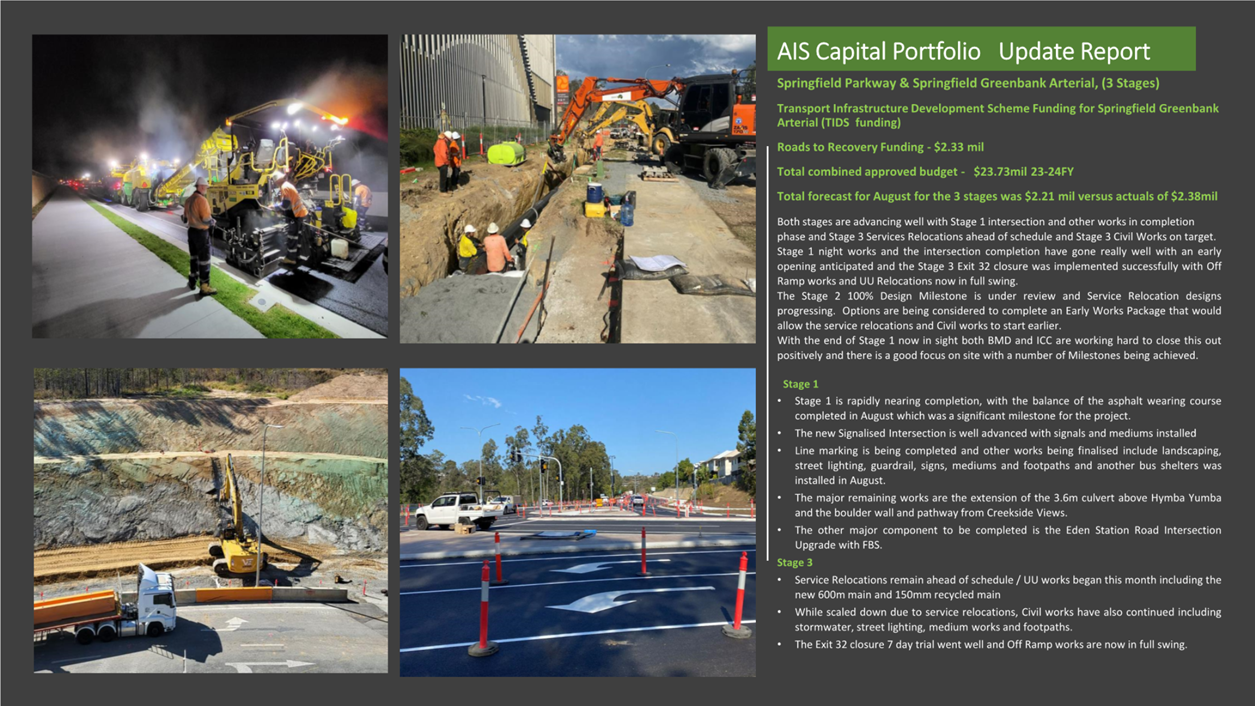
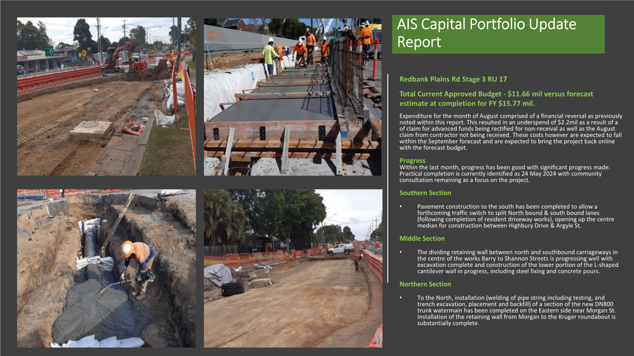
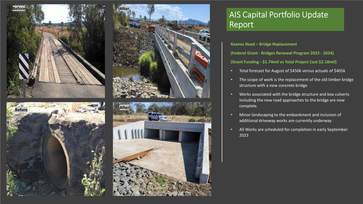
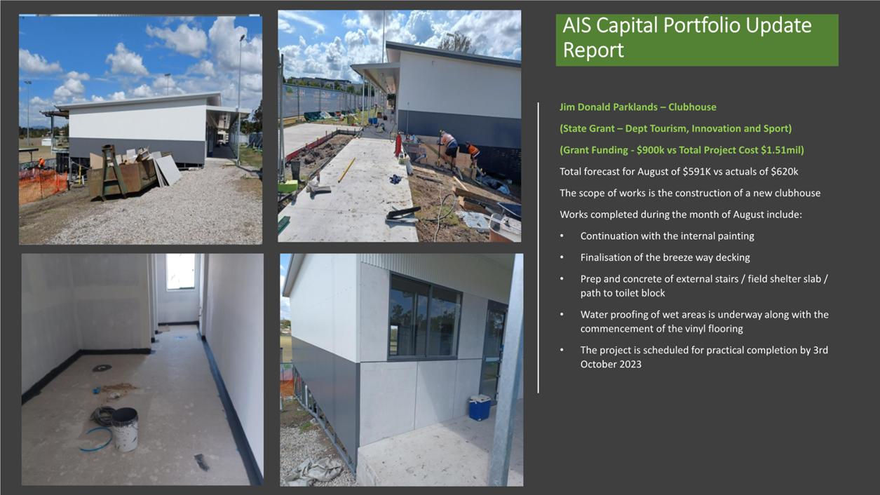
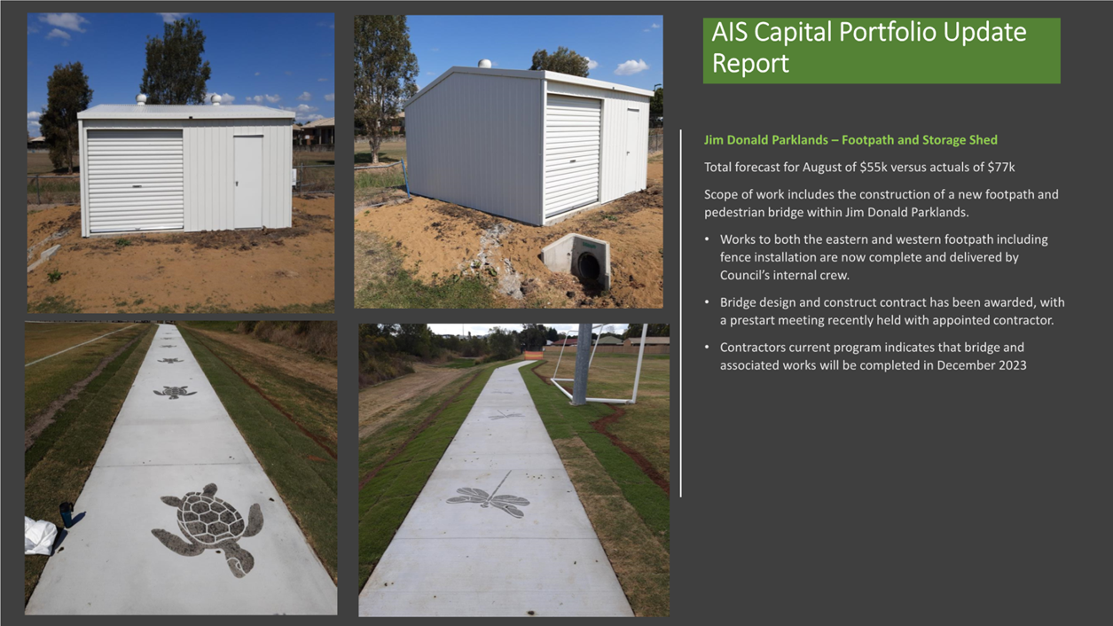
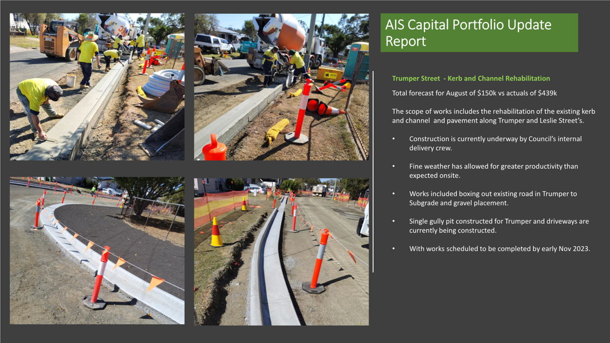
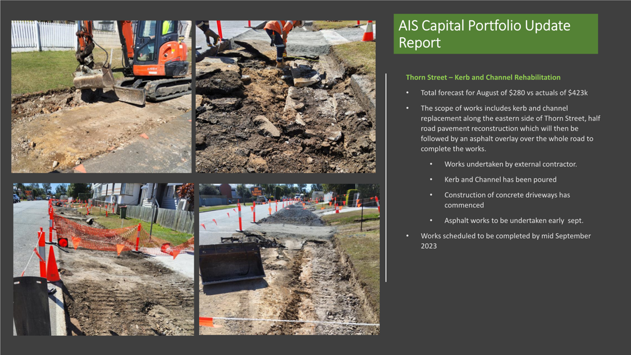
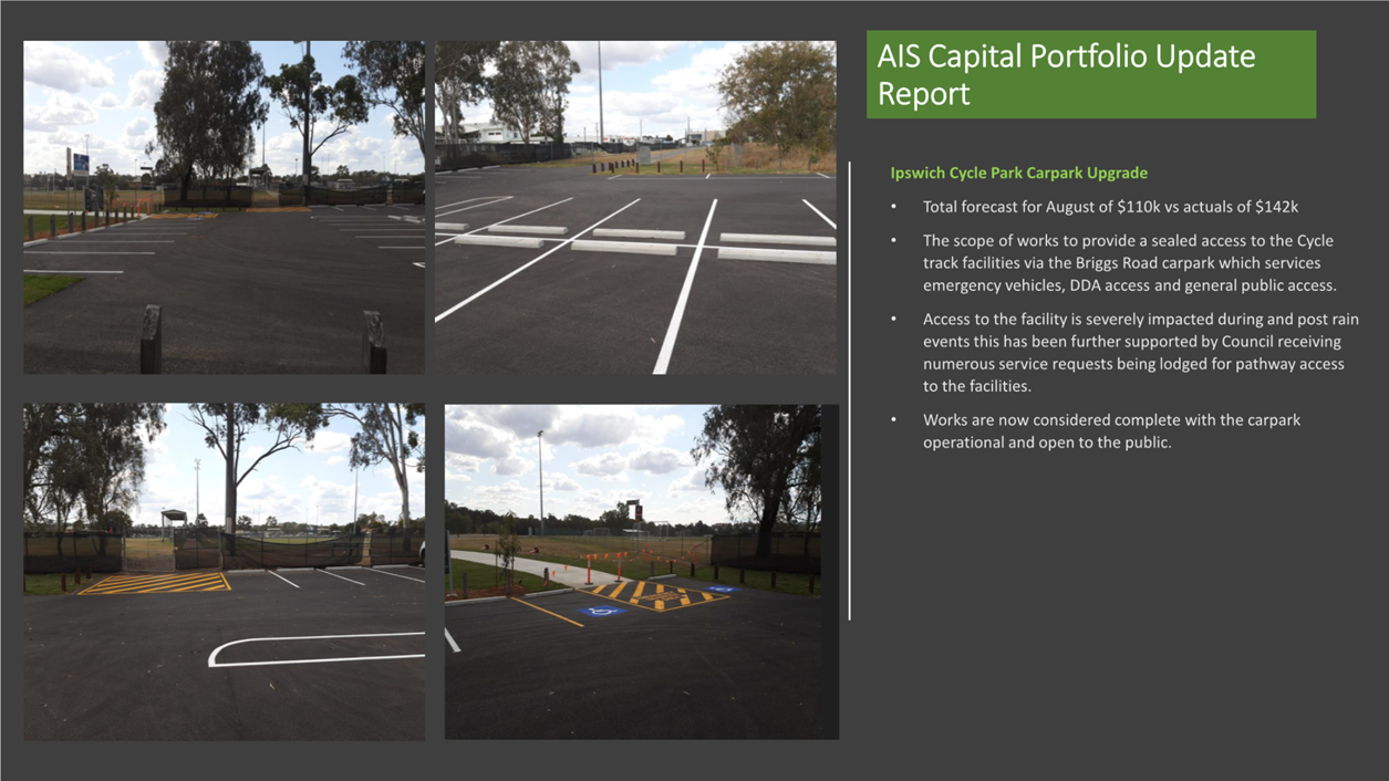
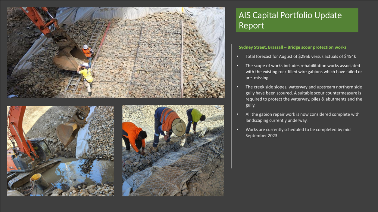
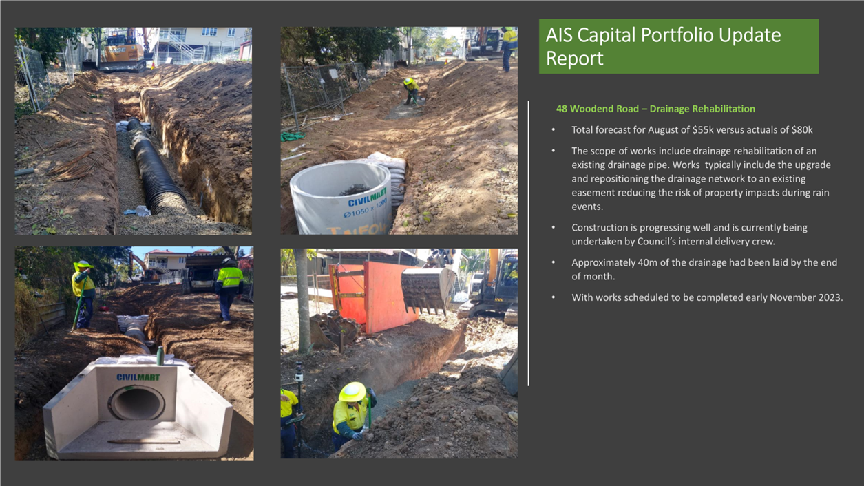
7. Asset and Infrastructure Services Department Capital Delivery Report August 2023
This is a report concerning the performance of the capital delivery by the Asset and Infrastructure Services Department for the month of August 2023.
Recommendation
That the report on capital delivery by the Asset and Infrastructure Services Department be received and the contents noted.
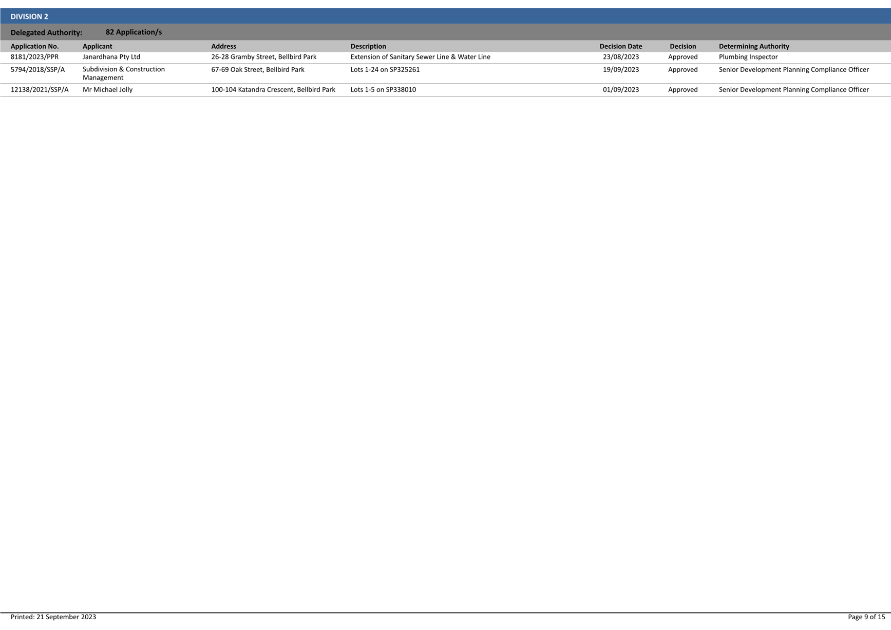
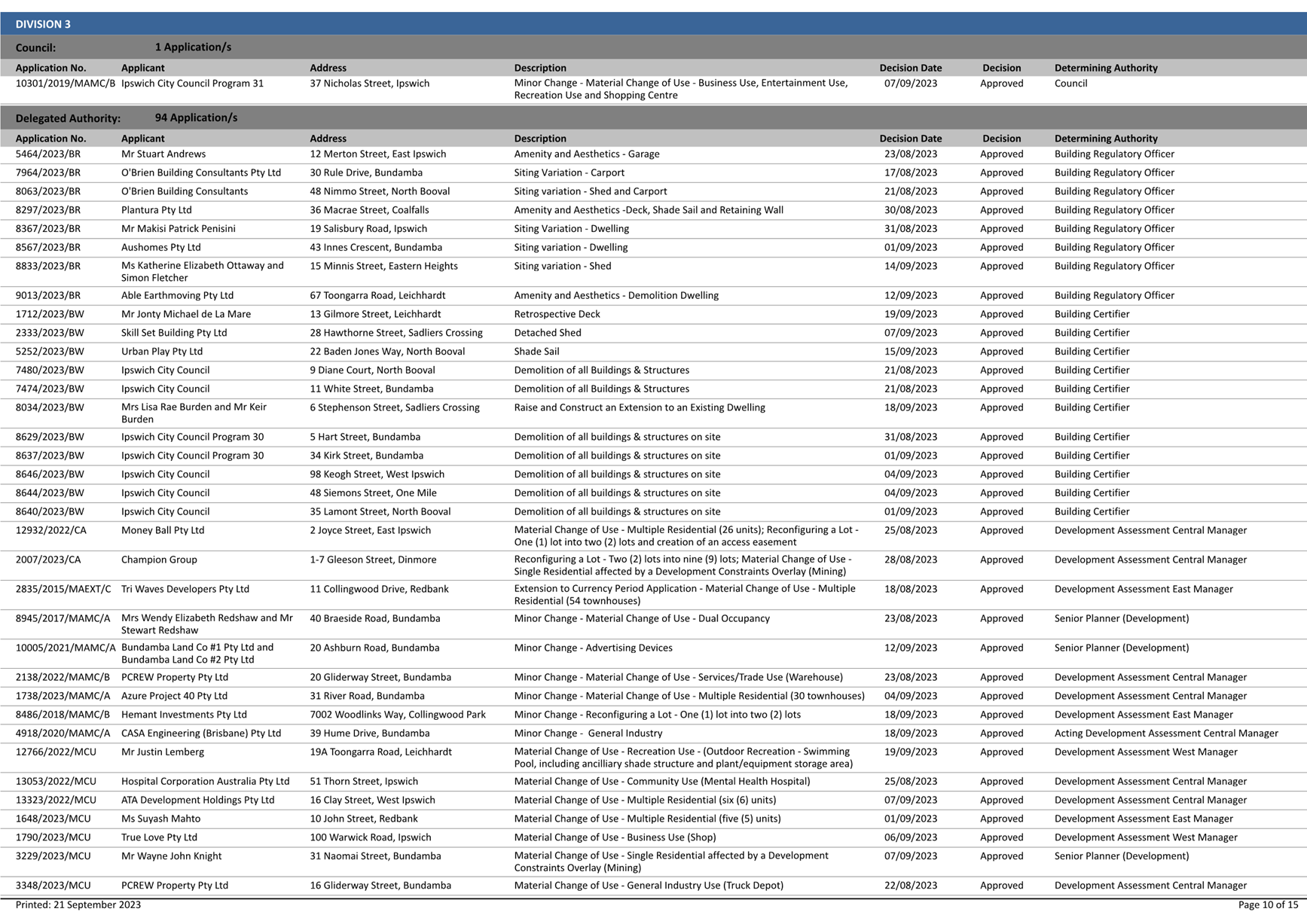
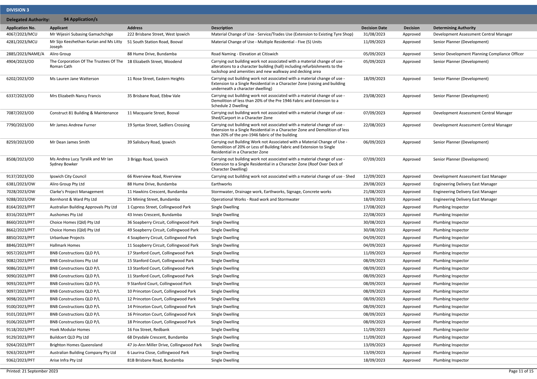
8. Exercise Of Delegation Report
This is a report concerning applications that have been determined by delegated authority for the period 17 August 2023 to 20 September 2023.
Recommendation
That the Exercise of Delegation
report for the period 17 August 2023 to
20 September 2023, be received and the contents noted.
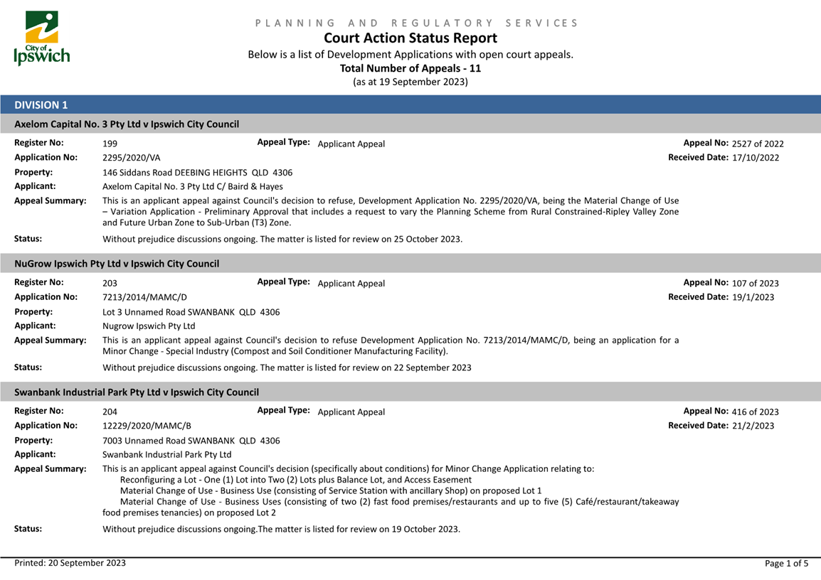
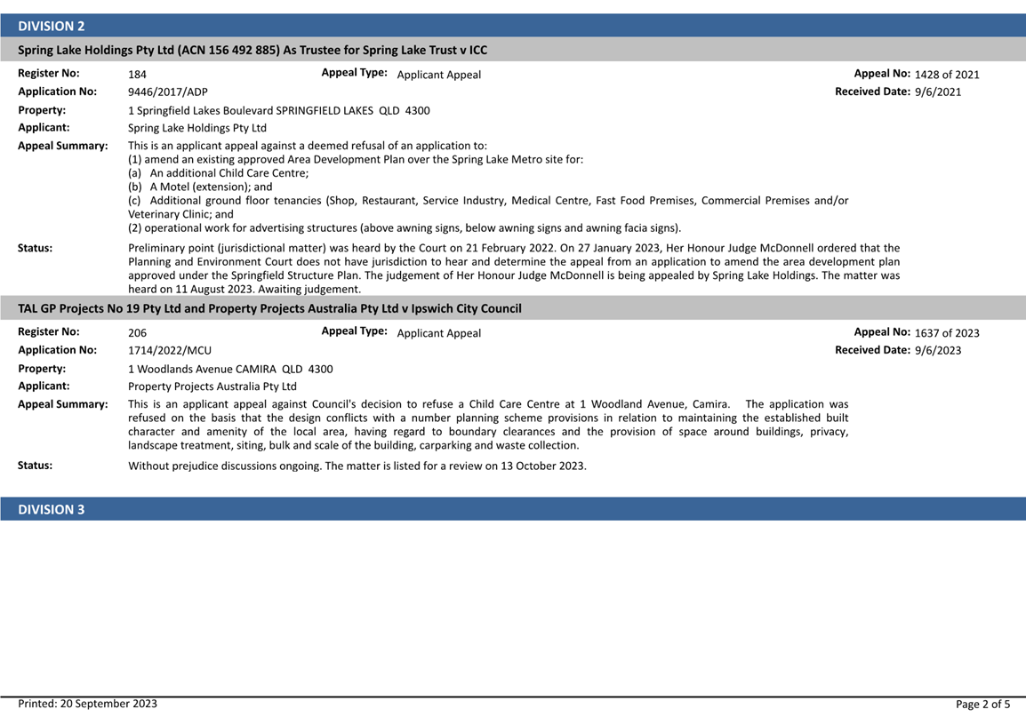
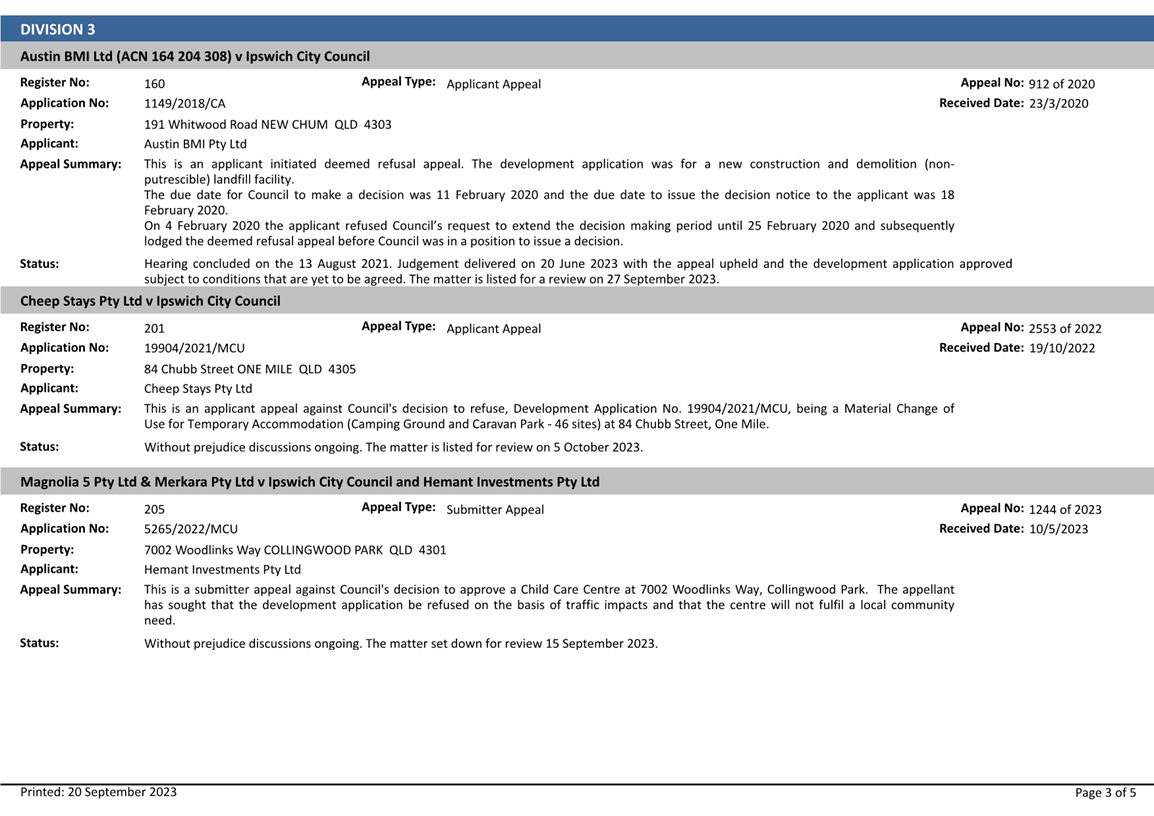
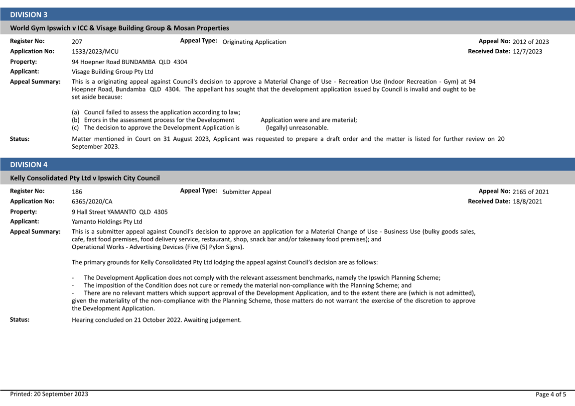
9. Planning and Environment Court Action Status Report
This is a report concerning a status update with respect to current court actions associated with development planning applications.
Recommendation
That the Planning and Environment Court Action status report be received and the contents noted.
10. **Sub-Regional Waste Alliance - MRF Investment Decision
This paper serves as the non-confidential holding paper for the detailed tender evaluation and business case for the potential establishment of Greenovate Pty Ltd as a Council owned beneficial enterprise to manage the future Sub Regional Alliance Material Recovery Facility.
The full reports are attached in the confidential attachment the Sub Regional Alliance Material Recovery Facility – Confidential Report - Tender Evaluation, Business Case and Establishment of Greenovate Pty Ltd Beneficial Enterprise.
REASON FOR CONFIDENTIALITY
It is recommended that this report be considered in a closed session pursuant to Section 254J of the Local Government Regulation 2012 (Qld) for the reason(s) that the matter involves:
Section 254J (3) (g) negotiations relating to a commercial matter involving the local government for which a public discussion would be likely to prejudice the interests of the local government
It is considered necessary to take the discussion of this report into a closed session as the confidential attachments contain information relating to contracts that may be made by Council as well as commercial-in-confidence financial information.
Additionally, as the Council owned commercial entity, that will be created pursuant to the report’s recommendations, will operate in a competitive commercial environment into the future, maintaining confidentiality of future projected operating cost is vital for its interests.
Recommendation
A. That the recommendations contained in confidential Attachment 1 be adopted.
B. That due to the confidential nature of the recommendations, that once adopted by Council, the recommendations be made public.
NOTICES OF MOTION
MATTERS ARISING
|
Growth Infrastructure and Waste Committee Meeting Agenda |
12 October 2023 |
ITEM: 1
SUBJECT: Response to Petition - Setting up of an Islamic section in an Ipswich cemetery
AUTHOR: Principal Officer (Projects)
DATE: 11 August 2023
This is a report concerning a petition that was presented to the Council meeting of 27 July 2023 requesting investigations into the setting up of an Islamic section in an Ipswich Cemetery. The recommendation of that report was to investigate the matter and provide a report back to the relevant committee.
That Council Officers continue to progress the establishment of an Islamic burial section at an Ipswich City Council managed cemetery.
RELATED PARTIES
Representatives of the Islamic community, including but not limited to the Islamic Council Queensland, Muslim Funeral Support, the Al Huda group and local Mosque leaders and members.
Norwood Park Pty Ltd as the contracted service provider for the Ipswich Cemetery Services (Death Care Services) Deed.
There have been no declarations of a conflict of interest in relation to this petition.
ifuture Theme
Safe, Inclusive and Creative
Purpose of Report/Background
Currently Ipswich City Council do not provide death care services that specifically cater to the needs for people of Islamic faith. Residents of the Ipswich City Council area who want a traditional Islamic faith burial generally are required to use the services of other cemeteries such as the Mt Gravatt Cemetery located in the Brisbane City Council area. The Mt Gravatt Cemetery does not have the capacity for expansion which will likely limit burial capacity in the future.
Traditional burials for a person of Islamic faith place the body generally in a North-South orientation as it is important for the deceased to be perpendicular to the qibla[1] or to the direction of Mecca. Additionally, Islamic faith does not allow for the body to be placed in a coffin or casket. Those burying the deceased will generally place the body with their right side facing the qibla on a layer of sand and then cover the body with a platform of wood to prevent the body from contacting the soil.
The cemeteries managed by the Ipswich City Council have burials plotted in an East-West orientation which is generally for people of Christian faith. Within the existing denominational cemeteries, there are no areas established for burials that would accommodate the Islamic faith. The Warrill Park Lawn Cemetery is considered a non-denominational cemetery however all burials are currently conducted with the body laid to rest in an East-West orientation.
In early 2023, representatives for the Islamic community approached Division 2 Councillor, Nicole Jonic, requesting a meeting be established with Council Officers to discuss the burial needs for their community members. On 8 March 2023, the initial meeting was held at which time the representatives for the Islamic community requested that Council consider establishing a burial section for persons of Islamic faith in a cemetery managed by the Ipswich City Council. Representatives at the meeting were invited to conduct site inspections of the Stone Quarry Cemetery and the Warrill Park Lawn Cemetery to ascertain if either cemetery would be suitable for their requirements.
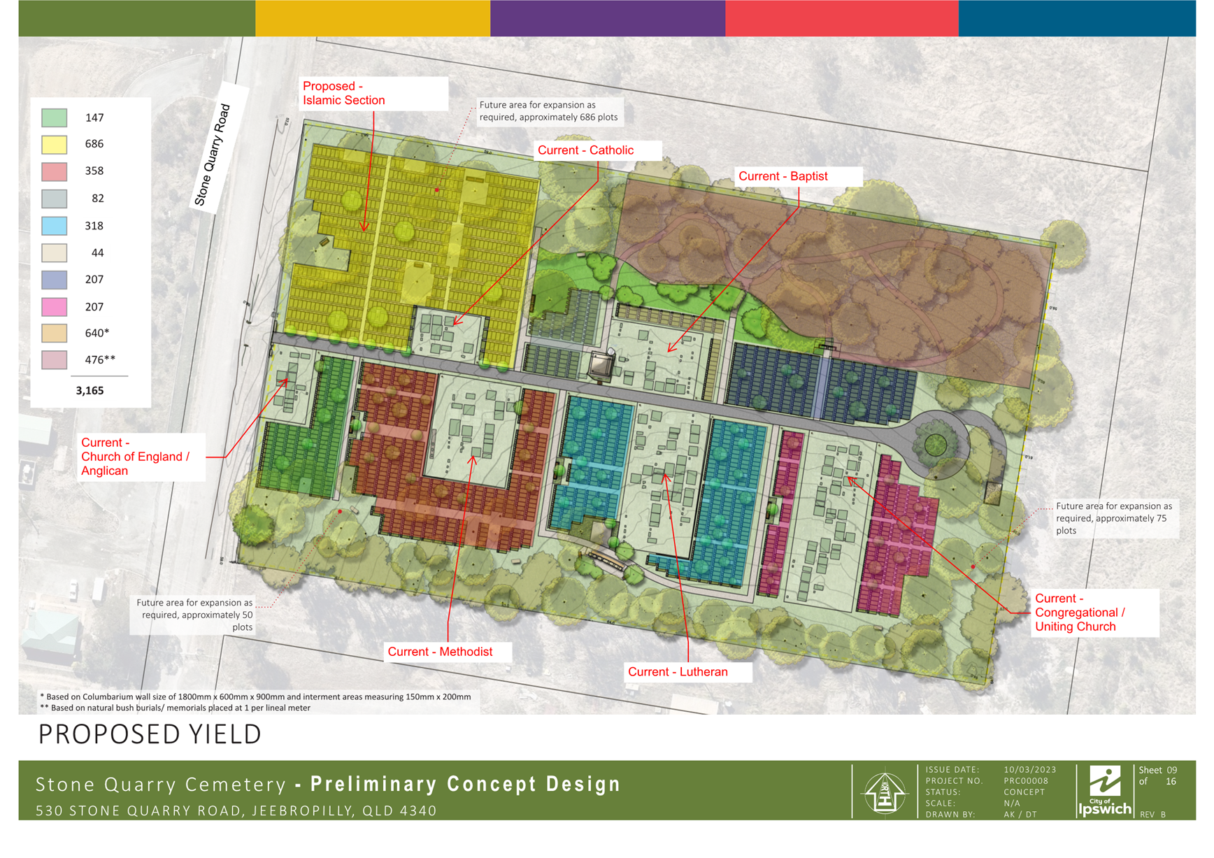
It was later determined that the Stone Quarry Cemetery was the most suitable location for establishing a new burial section for people of Islamic faith as this denominational cemetery has adequate space for growth and the amenity of the area was preferred by the Islamic community representatives. The preliminary concept design for the Stone Quarry Cemetery was reviewed and an area was identified that would yield approximately 686 burial plots as shown on Attachment 1.
Ongoing discussions have been maintained between Council Officers and the representatives regarding faith specific requirements and other site facility requirements.
It is understood that the petition was presented to Council to show that the community support the proposal of a new burial area within the Ipswich Council area that will cater for the needs of people of Islamic faith and that the community will use the area if it is established.
Legal IMPLICATIONS
This report and its recommendations are consistent with the following legislative provisions:
Local Government Act 2009
Local Government Regulation 2012
Local Law 7 (Local Government Controlled Areas and Roads)
Subordinate Local Law 7.1 (Local Government Controlled Areas and Roads)
Land Act 1994
Human Rights Act 2019
policy implications
Ipswich City Councils Human Rights Policy is relevant to this topic as the cultural rights (enjoyment of culture and religion) of the community need to be considered in this matter.
RISK MANAGEMENT IMPLICATIONS
There is a risk to the reputation of Ipswich City Council if the request to establish a burial area for people of Islamic faith was to be ignored. There is also a risk that Ipswich City Council could be considered in breach of the Human Rights Act 2019 by impacting on the cultural rights of persons within the Ipswich Community.
These risks have been reduced to minimal as investigations have commenced to determine if a suitable burial area can be established within a cemetery managed by the Ipswich City Council.
Financial/RESOURCE IMPLICATIONS
Funding has been allocated in the 2023-2026 Capital Works Program within corporate projects for initial investigation work to determine ground suitability for a new burial section to be established at the Stone Quarry Cemetery located at Jeebropilly.
Project PRC00033, Stone Quarry Islamic Burial section, which spans two (2) financial years has been created with initial geotechnical investigation work commencing in the current 2023-2024 financial year. Additional funding has been allocated for preliminary work to improve the site in the 2024-2025 financial year should the cemetery be identified as a suitable location for establishing a new burial section.
COMMUNITY and OTHER CONSULTATION
In March 2023, consultation commenced with representatives of the Islamic community, including leaders of local Mosques, the Al Huda group and Muslim Funeral Services. Later in the same month, site meetings were held at both the Stone Quarry Cemetery and the Warrill Park Lawn Cemetery.
Council Officers have consulted with representatives from Brisbane City Council in relation to the Islamic burial section located at the Mt Gravatt Cemetery to ensure that they are aware of all aspects and requirements of burials for a deceased person of Islamic faith.
Consultation has continued with the Imam[2] of the Camira Mosque in relation to likely charges for death care services, faith specific community requirements and suggested facility improvements.
Representatives of Norwood Park Pty Ltd have also been involved with the initial consultation and site meetings and ongoing discussions.
Conclusion
The initial geotechnical investigation work at Stone Quarry Cemetery will likely take between three (3) to five (5) months. On the completion of a geotechnical report, Council Officers will be able to determine if the ground is suitable for the establishment of a new burial section at the Stone Quarry Cemetery. If the report is favourable, action will continue to improve the site in accordance with the approved project. Regular communication will continue with the stakeholders.
HUMAN RIGHTS IMPLICATIONS
|
HUMAN RIGHTS IMPACTS |
|
|
OTHER DECISION |
|
|
|
|
|
(a) What is the Act/Decision being made? |
The Recommendation states that Council Officers continue to progress the establishment of an Islamic burial section at an Ipswich City Council managed cemetery. |
|
(b) What human rights are affected? |
No human rights are affected by this decision as the cultural rights (enjoyment of culture and religion) of the community are not being restricted by this decision. |
|
(c) How are the human rights limited? |
Not applicable.
|
|
(d) Is there a good reason for limiting the relevant rights? Is the limitation fair and reasonable? |
Not applicable.
|
|
(e) Conclusion |
The decision is consistent with human rights. |
Attachments and Confidential Background Papers
|
1 |
Potential burial plot locations ⇩ |
Graham Schultz
Principal Officer (Projects)
I concur with the recommendations contained in this report.
Alisha Connaughton
Manager, Compliance
I concur with the recommendations contained in this report.
Brett Davey
General Manager Planning and Regulatory Services
“Together, we proudly enhance the quality of life for our community”
|
Growth Infrastructure and Waste Committee Meeting Agenda |
12 October 2023 |
Growth Infrastructure and Waste Committee NO. 2023(08)
5 September 2023
Minutes
COUNCILLORS’ ATTENDANCE: Mayor Teresa Harding (Chairperson); Councillors Paul Tully (Deputy Chairperson), Sheila Ireland, Jacob Madsen, Marnie Doyle, Andrew Fechner, Kate Kunzelmann, Deputy Mayor Russell Milligan and Nicole Jonic
COUNCILLOR’S APOLOGIES: Nil
OFFICERS’ ATTENDANCE: Chief Executive Officer (Sonia Cooper), General Manager Planning and Regulatory Services (Brett Davey), General Manager Corporate Services (Matt Smith), General Manager Community, Cultural and Economic Development (Ben Pole), General Manager Environment and Sustainability (Kaye Cavanagh), General Manager Asset and Infrastructure Services (Matt Anderson), Manager, Capital Program Delivery (Graeme Martin), Chief Financial Officer (Jeff Keech), Chief of Staff - Office of the Mayor (Melissa Fitzgerald), Manager Media Communications and Engagement (Mark Strong), Manager People and Culture (Talia Love-Linay), Manager, Procurement (Richard White), Manager, Resource Recovery (David McAlister), Development Planning Manager (Anthony Bowles), Manager, Senior Communications and Policy Officer (Jodie Richter), Senior Media Officer (Darrell Giles), Senior Media Officer (Lucy Stone), Business Applications Transformation Specialist (Shane Andrews) and Theatre Technician (Harrison Cate)
|
Welcome to Country or Acknowledgement of Country
Mayor Teresa Harding (Chairperson) delivered the Acknowledgement of Country |
DECLARATIONS OF INTEREST IN MATTERS ON THE AGENDA
|
cOUNCILLOR ANDREW FECHNER
In accordance with section 150EQ of the Local Government Act 2009, Councillor Andrew Fechner informed the meeting that he has a declarable conflict of interest in Item 7 titled Development Application Recommendation (Minor Change) 10301/2019/MAMC/B.
The nature of the declarable conflict of interest is that Councillor Fechner stands to gain a benefit or suffer a loss due to his business interest in both A1A Events Pty Ltd and Bar Heisenberg Pty Ltd which is located in the top of town at 164 Brisbane Street, Ipswich.
Councillor Andrew Fechner came to the conclusion that because of the nature of the conflict, he will exclude himself from the meeting while this matter is debated and the vote taken. |
|
COUNCILLOR JACOB MADSEN
In accordance with section 150EQ of the Local Government Act 2009, Councillor Jacob Madsen informed the meeting that he has a declarable conflict of interest in Item 7 titled Development Application Recommendation (Minor Change) 10301/2019/MAMC/B.
The nature of the declarable conflict of interest is that Councillor Madsen is a member of the Ipswich Trades Hall and Labour Day Committee Executive which manages the Ipswich Trades Hall which is adjacent to the CBD redevelopment works that Council is undergoing.
Councillor Jacob Madsen came to the conclusion that because of the nature of the conflict, he will exclude himself from the meeting while this matter is debated and the vote taken. |
MATTER FOR RECOMMENDATION TO COUNCIL
BUSINESS OUTSTANDING
|
1. Overview of Council's Approach to Heritage 2023 This is a report concerning response to previous committee reports and resolutions of September and November 2022. The report is an Overview of Council’s functions that deal with Heritage matters. The overview is intended to contribute to the development of a Heritage Plan for the Council and has been prepared as a direct result of workshops held with the Mayor and Councillors in early 2023 as well as a series of internal workshops to understand, as much as possible, the extent of heritage interests dealt with by Council’s operations. This work highlighted the diverse range of projects that are undertaken across Council branches and departments. It also highlighted the need for increased collaboration and coordination for projects that may have a history or heritage component to avoid duplication of research and to increase cross-council knowledge of Ipswich history. The attached report, “An Overview of Council’s Approach to Heritage 2023”, is the first stage of developing a Heritage Plan. Work in this space will continue to the preparation of an Ipswich Heritage Plan. |
|
RECOMMENDATION Moved by Mayor Teresa Harding: Seconded by Councillor Marnie Doyle: That the report titled ‘Overview of Council’s approach to Heritage 2023” be received and the contents noted.
|
|
AFFIRMATIVE NEGATIVE Councillors: Councillors: Harding Madsen Tully Ireland Doyle Fechner Kunzelmann Milligan Jonic
The motion was put and carried. |
Confirmation of Minutes
|
2. Confirmation of Minutes of the Growth Infrastructure and Waste Committee No. 2023(07) of 10 August 2023 |
|
RECOMMENDATION Moved by Mayor Teresa Harding: Seconded by Councillor Andrew Fechner: That the Minutes of the Growth, Infrastructure and Waste Committee held on 10 August 2023 be confirmed.
|
|
AFFIRMATIVE NEGATIVE Councillors: Councillors: Harding Madsen (Abstain) Tully Ireland Doyle Fechner Kunzelmann Milligan Jonic
The motion was put and carried. |
Officers’ Reports
Matter to be resolved under delegation
(in accordance with section 257(1)(c) of the Local Government Act 2009, the Growth, Infrastructure and Waste Committee has been delegated power to make decisions on behalf of Council for decisions made under the Planning Act 2016 and the
Economic Development Act 2012)
|
3. Temporary Local Planning Instrument 1/2023 - Resource Recovery and Waste Activity Regulation This is a report concerning the proposed renewal of the Temporary Local Planning Instrument (TLPI) No. 1 of 2021 (TLPI 1/2021) which regulates resource recovery and waste activity uses in the Swanbank/New Chum and Ebenezer/Willowbank/Jeebropilly Regulation Areas within the TLPI boundary. In accordance with the Planning Act 2016, the TLPI expires on 10 December 2023. It is proposed to remake the TLPI to reflect the provisions of the existing TLPI in order to facilitate the temporary extension of the current resource recovery and waste activity use assessment provisions. |
|
DECISION Moved by Mayor Teresa Harding: Seconded by Councillor Andrew Fechner: A. That Council make Temporary Local Planning Instrument No. 1 of 2023 (Resource Recovery and Waste Activity Regulation) being Temporary Local Planning Instrument No. 1 of 2021 (Resource Recovery and Waste Activity Regulation) with amendments as detailed in Attachment 1. B. That Council write to the Minister for State Development, Infrastructure, Local Government and Planning and Minister Assisting the Premier on Olympic and Paralympic Games Infrastructure requesting consideration and approval of the proposed Temporary Local Planning Instrument No.1 of 2023, including a final version of the TLPI in accordance with Attachment 1. C. That
post state government approval, Temporary Local Planning Instrument No. 1 of
2023 (Resource Recovery and Waste Activity Regulation) have an early
effective day of 11 December 2023. |
|
AFFIRMATIVE NEGATIVE Councillors: Councillors: Harding Nil Tully Ireland Madsen Doyle Fechner Kunzelmann Milligan Jonic
The motion was put and carried. |
MATTERS FOR RECOMMENDATION TO COUNCIL
|
4. Asset and Infrastructure Services Department Capital Delivery Report July 2023 This is a report concerning the performance of the capital delivery by the Asset and Infrastructure Services Department for the month of July 2023. |
|
RECOMMENDATION Moved by Mayor Teresa Harding: Seconded by Deputy Mayor Russell Milligan: That the report on capital delivery by the Asset and Infrastructure Services Department be received and the contents noted.
|
|
AFFIRMATIVE NEGATIVE Councillors: Councillors: Harding Nil Tully Ireland Madsen Doyle Fechner Kunzelmann Milligan Jonic
The motion was put and carried. |
|
5. Exercise Of Delegation Report This is a report concerning applications that have been determined by delegated authority for the period 26 July 2023 to 17 August 2023. |
|
RECOMMENDATION Moved by Mayor Teresa Harding: Seconded by Councillor Kate Kunzelmann: That the Exercise of Delegation report for the period 26 July 2023 to 17 August 2023, be received and the contents noted.
|
|
AFFIRMATIVE NEGATIVE Councillors: Councillors: Harding Nil Tully Ireland Madsen Doyle Fechner Kunzelmann Milligan Jonic
The motion was put and carried. |
|
6. Planning and Environment Court Action Status Report This is a report concerning a status update with respect to current court actions associated with development planning applications. |
|
RECOMMENDATION Moved by Mayor Teresa Harding: Seconded by Councillor Nicole Jonic: That the Planning and Environment Court Action status report be received and the contents noted.
|
|
AFFIRMATIVE NEGATIVE Councillors: Councillors: Harding Nil Tully Ireland Madsen Doyle Fechner Kunzelmann Milligan Jonic
The motion was put and carried. |
Matter to be resolved under delegation
(in accordance with section 257(1)(c) of the Local Government Act 2009, the Growth, Infrastructure and Waste Committee has been delegated power to make decisions on behalf of Council for decisions made under the Planning Act 2016 and the
Economic Development Act 2012)
Councillors Andrew Fechner and Jacob Madsen left the meeting at 9.12 am due to a previously declared interest in Item 7.
|
7. Development application recommendation (minor change) 10301/2019/MAMC/B This is a report concerning a change request to development application number 10301/2019/MAMC/A for a Material Change of Use - Business Use, Entertainment Use, Recreation Use & Shopping Centre to be predominantly undertaken within existing, refurbished buildings, which form part of the redevelopment of the Nicholas Street and Union Place Precinct by Ipswich City Council. The application seeks amendments to the approved plans for the development and an amendment to one (1) condition of the approval consequential to the proposed plan changes. The subject application requires determination by Council in accordance with the Framework for Development Applications and Related Activities Policy as the minor change application has been made by Council and does not relate to the provision of standard local government infrastructure. Further, the application is considered a Sensitive Development Matter and is required to be reviewed by an Independent Decision Review Panel. The minor change request is recommended to be approved. |
|
DECISION Moved by Mayor Teresa Harding: Seconded by Councillor Marnie Doyle: That Council resolve to approve development application no. 10301/2019/MAMC/B subject to conditions as contained in Attachment 2 of this report.
|
|
AFFIRMATIVE NEGATIVE Councillors: Councillors: Harding Ireland (Abstain) Tully Doyle Kunzelmann Milligan Jonic All Councillors except Councillor
Andrew Fechner and Jacob Madsen were present when the vote was taken. |
Councillors Andrew Fechner and Jacob Madsen returned to the meeting at 9.19 am.
|
NOTICES OF MOTION
Nil |
|
MATTERS ARISING
Nil |
PROCEDURAL MOTIONS AND FORMAL MATTERS
The meeting commenced at 9.00 am.
The meeting closed at 9.20 am.
|
Growth Infrastructure and Waste Committee Meeting Agenda |
12 October 2023 |
ITEM: 3
SUBJECT: Development Application Recommendation - 13198/2022/CA Combined application for Development of 48-70 and 84 Pindari Drive and 67-103 Dances Road, Thagoona for residential purposes
AUTHOR: Acting Development Assessment Central Manager
DATE: 26 September 2023
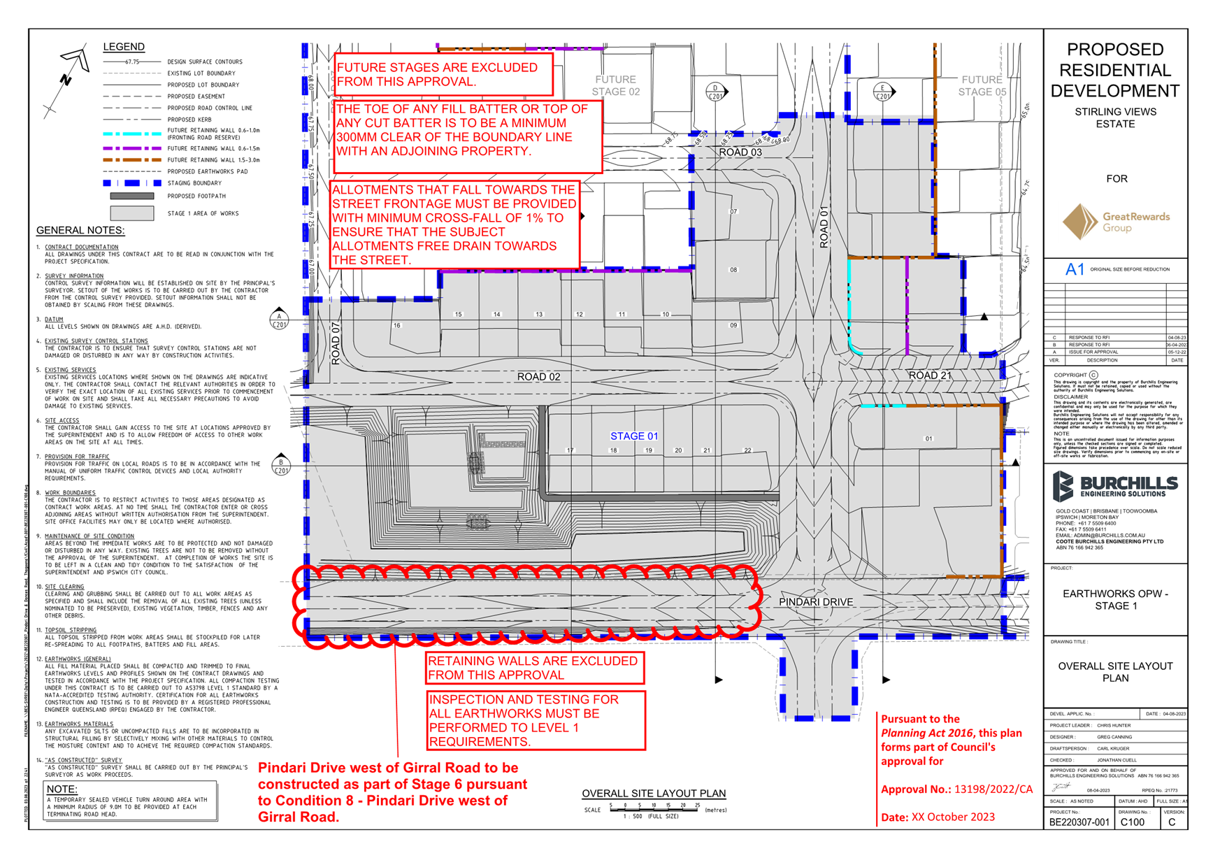
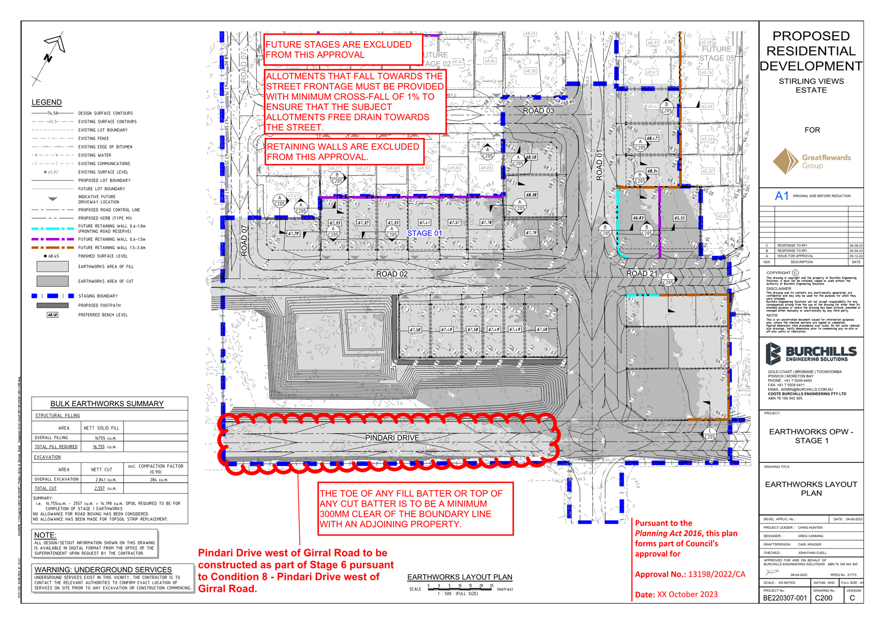
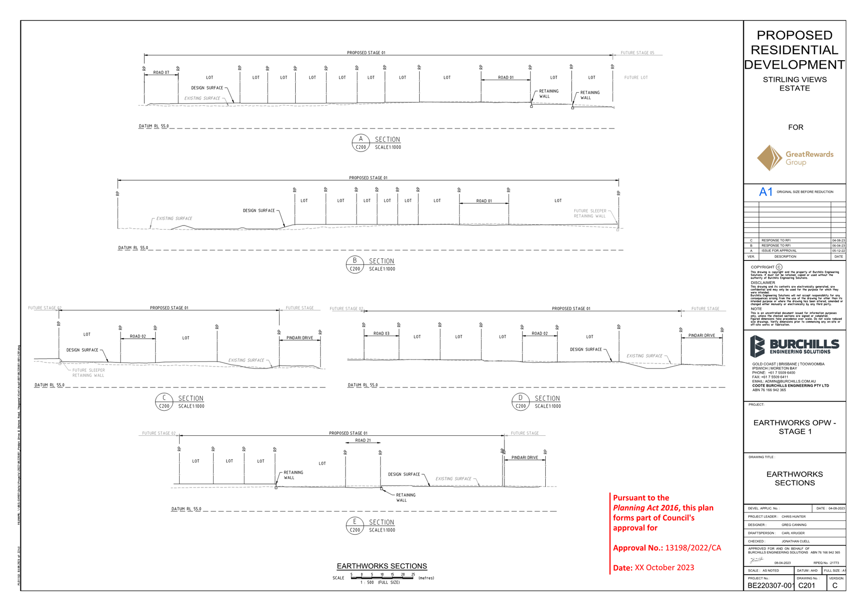
This is a report concerning an application seeking approval for a Preliminary Approval that includes a variation request for a Material Change of Use for Residential Uses (Display Housing, Dual Occupancy, Multiple Residential and Single Residential Uses) and Reconfiguring a Lot (359 lots over whole site), a Development Permit for Reconfiguring a Lot - Three (3) Lots into Twenty-Four (24) Lots and a Development Permit for Operational Works for bulk earthworks and vegetation clearing associated with Stage 1 (24 lots) at 48-70 Pindari Drive and 84 Pindari Drive, and 67-103 Dances Road, Thagoona.
Parts of the Walloon and Thagoona areas have been planned for urban growth since 2006, with preparation of a planning study occurring between 2003 and 2005 resulting in changes to the Ipswich Planning Scheme in 2006. The ultimate plan for this area was included in the Ipswich Planning Scheme as a Land Use Concept Master Plan. The proposed development is consistent with this land use concept master plan.
The proposed development has been assessed with regard to the applicable assessment benchmarks. The proposed development generally complies with the assessment benchmarks or can be conditioned to comply as outlined below.
That Council approve development application no. 13198/2022/CA subject to conditions and attachments.
RELATED PARTIES
|
Applicant and Planning, Ecological and Bushfire Consultant |
Sargeant Planning, primary contact Boyd Sargeant |
|
Owner |
TPDP 2 Pty Ltd |
|
Related Entities to owner |
Great Rewards Group Pty Ltd Golden Landlink Investments Pty Ltd |
|
Traffic Engineers |
SLR Consulting Australia Pty Ltd |
|
Civil and Stormwater Engineers |
Burchills Engineering Solutions |
ifuture Theme
Vibrant and Growing
Purpose of Report/Background
|
SITE ADDRESS: |
48-70 Pindari Drive and 84 Pindari Drive, and 67-103 Dances Road, THAGOONA QLD 4306 |
|
APPLICATION TYPE: |
Combined Approval |
|
PROPOSAL: |
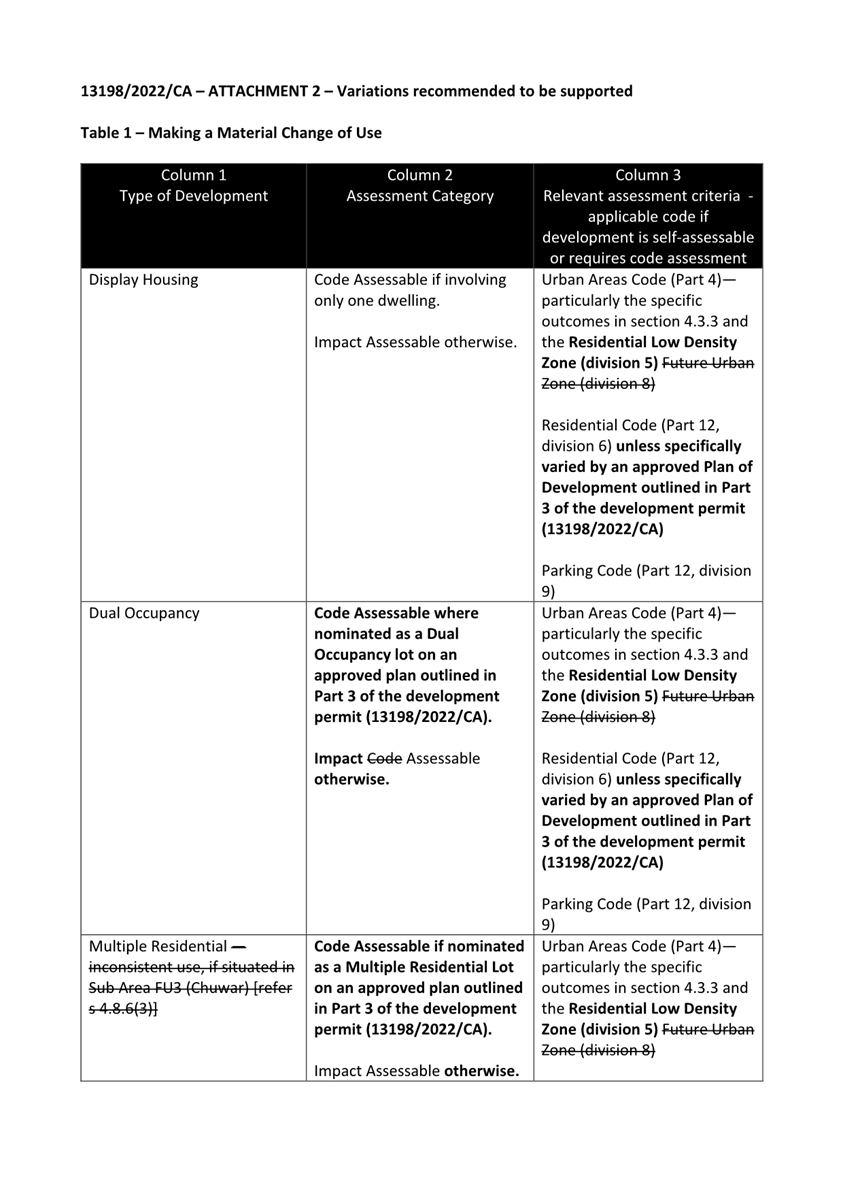
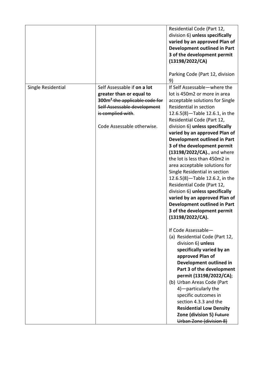
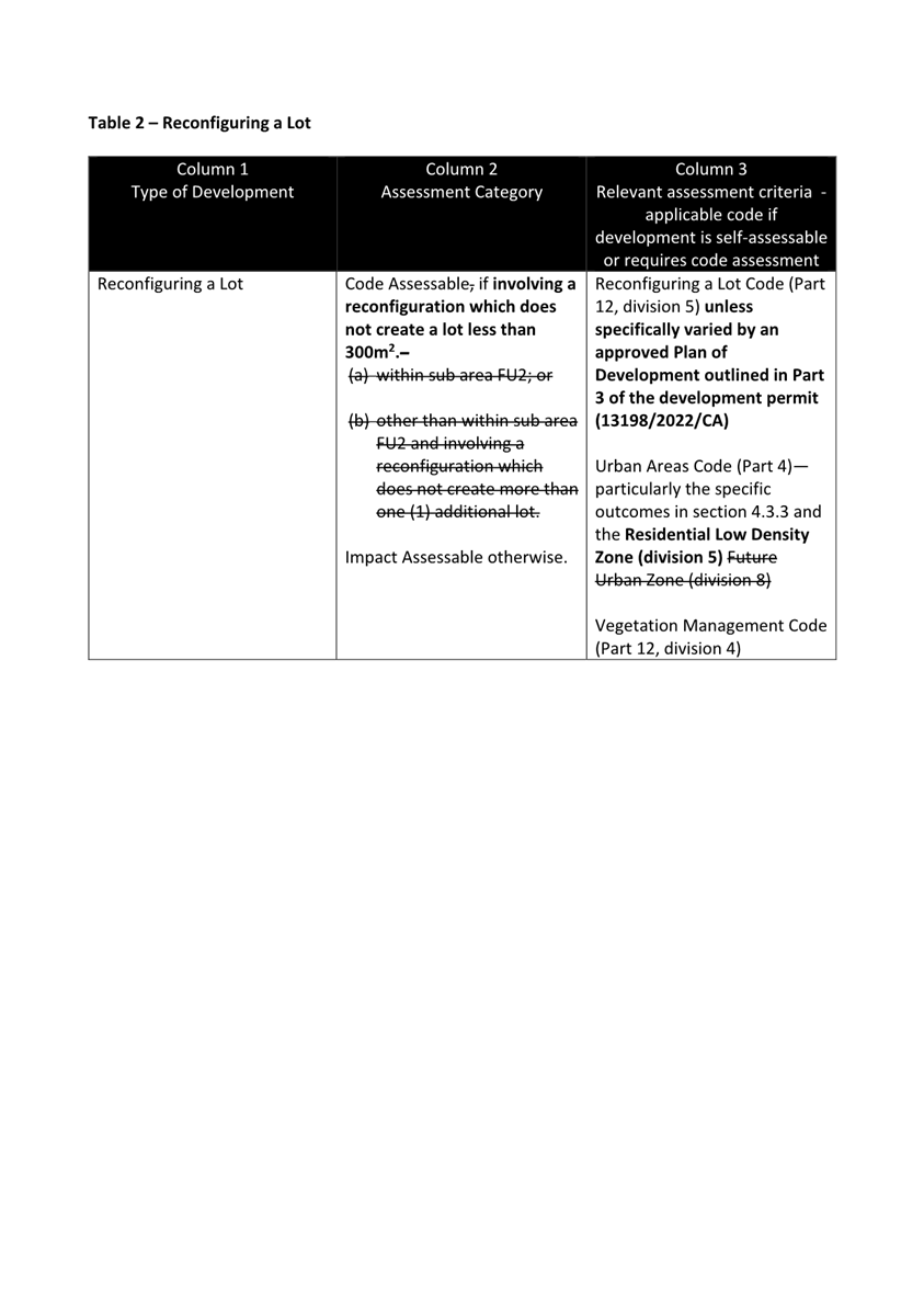
Preliminary Approval for a Material Change of Use for Residential Uses (Display Housing, Dual Occupancy, Multiple Residential and Single Residential Uses) and Reconfiguring a Lot (359 lots over whole site)
Development Permit for Reconfiguring a Lot - Three (3) Lots into Twenty-Four (24) Lots
Development Permit for Operational Works for bulk earthworks and vegetation clearing associated with Stage 1 (24 lots) |
|
ZONE: |
Future Urban Zone (Sub Area FU4 – Walloon/Thagoona) Large Lot Residential (32.47% of 67-103 Dances Road Thagoona) |
|
OVERLAYS: |
OV7A – Building Height Restriction Area 45m & 90m, Outer Horizontal Surface RL 176.5 and Transitional Surface OV7B - 8km Existing Committed Urban Townships Buffer |
|
APPLICANT: |
Sargeant Planning |
|
OWNER: |
TPDP 2 Pty Ltd |
|
EXISTING OR PROPOSED TRADING NAMES: |
Stirling Views Estate |
|
APPLICATION NO: |
13198/2022/CA |
|
AREA: |
121,410m2 (12.41ha) – 48-70 Pindari Drive 115,900m2 (11.59ha) – 84 Pindari Drive 119,000m2 (11.9 ha) – 67-103 Dances Road
Total – 356,310m2 (35.631ha) |
|
REFERRAL AGENCIES: |
Department of State Development, Infrastructure, Local Government and Planning (State Assessment and Referral Agency) |
|
EXISTING USE: |
Vacant grazing |
|
PREVIOUS RELATED APPROVALS: |
Nil |
|
DATE RECEIVED: |
16 December 2022 |
|
DECISION PERIOD START DATE: |
30 June 2023 |
|
EXPECTED DETERMINATION DATE: |
12 October 2023 |
SITE LOCATION:
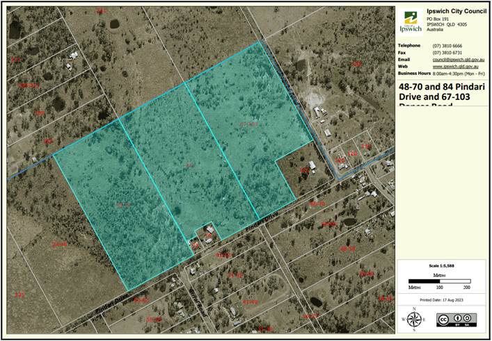
Figure 1 – Locality plan
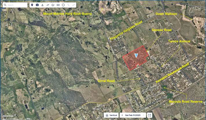
Figure 2 – Site context
SITE DETAILS AND SURROUNDING LAND USES:
The site is large and irregular in shape and has a varied topography that can be characterised as undulating with two (2) small ridgelines running broadly north-south through the western and easternmost lots and a flatter area including an ephemeral waterway. The site is vacant and has been historically used for grazing and largely consists of improved pastures as well as areas established native vegetation regrowth. Its boundaries are defined to the north and west by adjoining properties, to the south by the Pindari Drive road reserve and to the east by the Dances Road reserve.
The properties adjoining to the north and west are similarly large, rural properties, and the three (3) properties adjoining to the south are smaller properties that are the result of historical subdivisions in 1976, 1989 and 2022. The surrounding area to the south is an established large lot area of Thagoona, largely the result of subdivision that occurred in the 1970s and 1980s.
The subject site and surrounding areas are nominated in ShapingSEQ (the South East Queensland Regional Plan 2017), as well as the Ipswich Planning Scheme for substantial urban growth by expansion, in recognition of accessibility to existing transport facilities and proximity to services and facilities.
PROPOSAL:
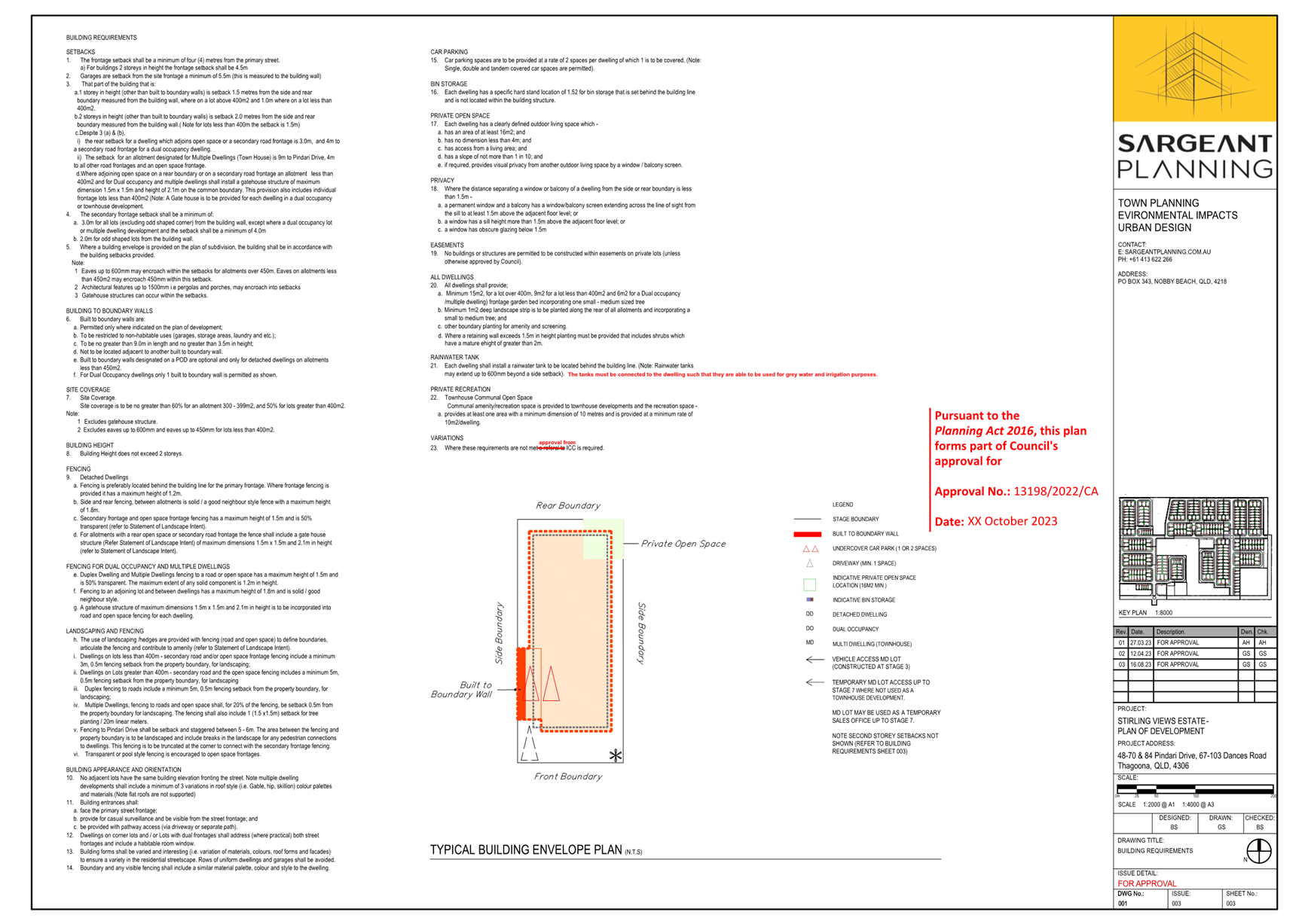
The proposed development includes a Preliminary Approval including a variation request for a Material Change of Use for Residential Uses (Display Housing, Dual Occupancy, Multiple Residential and Single Residential Uses) and Reconfiguring a Lot (359 lots over whole site) and a Development Permit for Reconfiguring a Lot and Operational Works involving the first 24 lots as part of proposed Stage 1. More detail on these individual components is provided below.
Preliminary Approval including a variation request
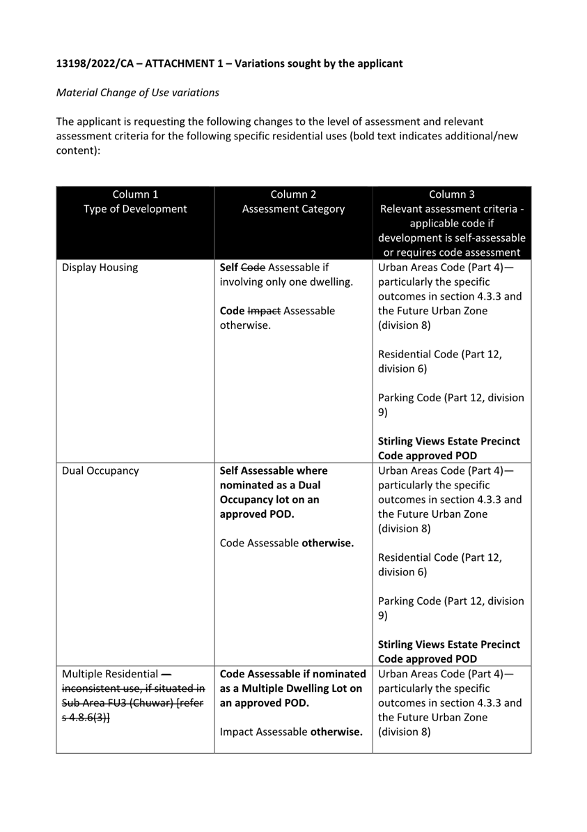
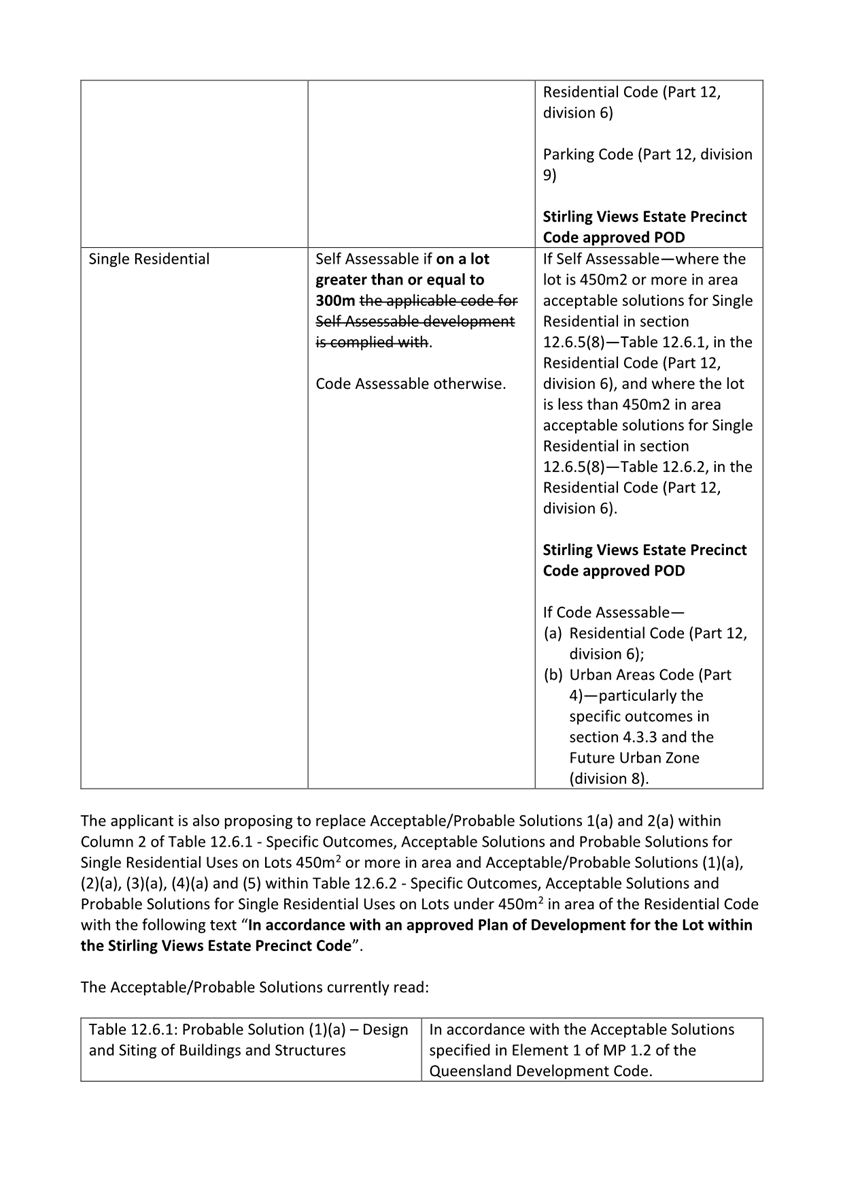
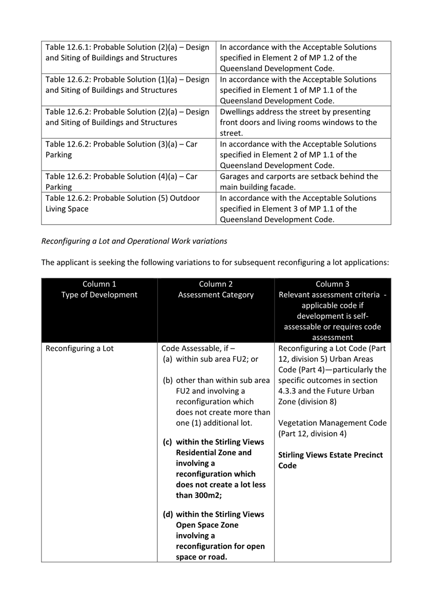
The proposed development seeks preliminary approval (which does not by itself authorise development to be carried out) for a Material Change of Use for four (4) separate residential uses defined by the Ipswich Planning Scheme 2006 including display housing, dual occupancy, multiple residential and single residential and also for Reconfiguring a Lot for 359 lots across the whole site. As part of the preliminary approval the applicant is also proposing a variation request that will alter the level of assessment and relevant assessment benchmarks for these subsequent uses, subdivision and vegetation clearing applications. The variations sought as part of the preliminary approval and their effects are outlined further below in the Variation Request section of the report.
In summary, the applicant seeks to:
- Vary the level of assessment and relevant assessment benchmarks for subsequent specified residential uses, reconfiguring a lot and operational works for vegetation clearing applications;
- Vary acceptable/probable solutions relevant to single residential uses in the Residential Code, and
- Establish overall building setbacks, envelopes and design standards for the proposed development.
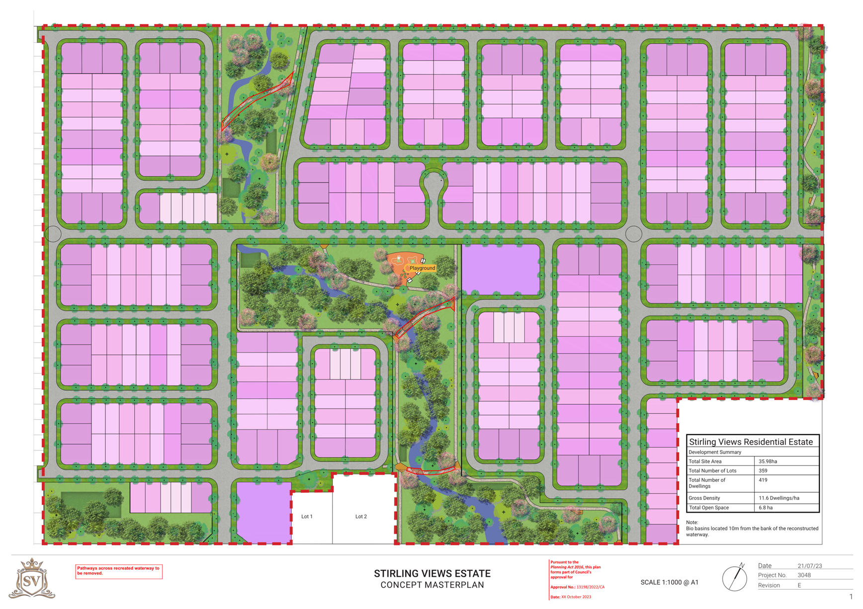
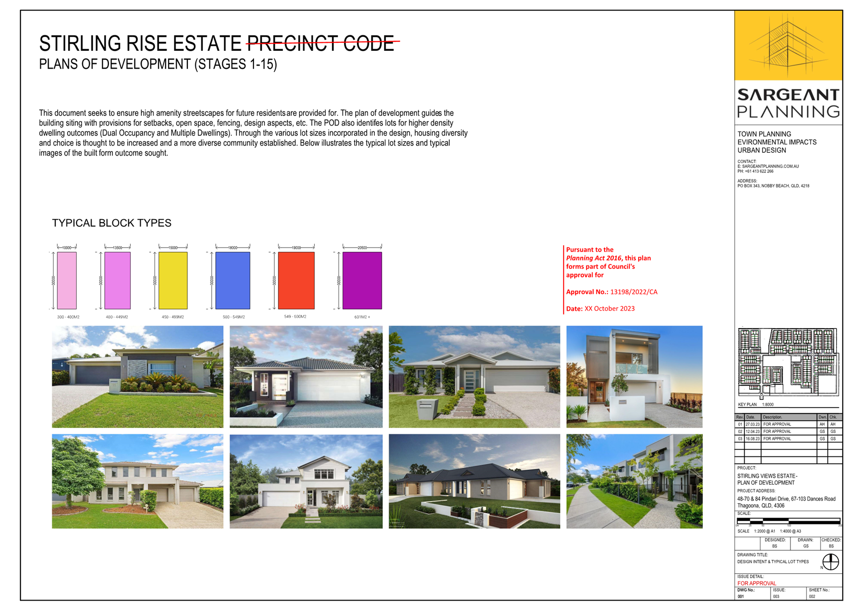
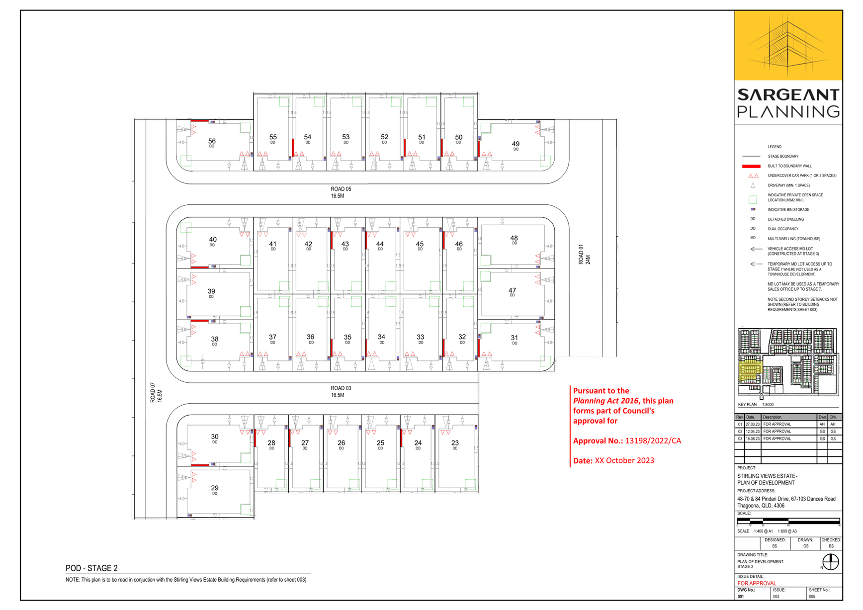
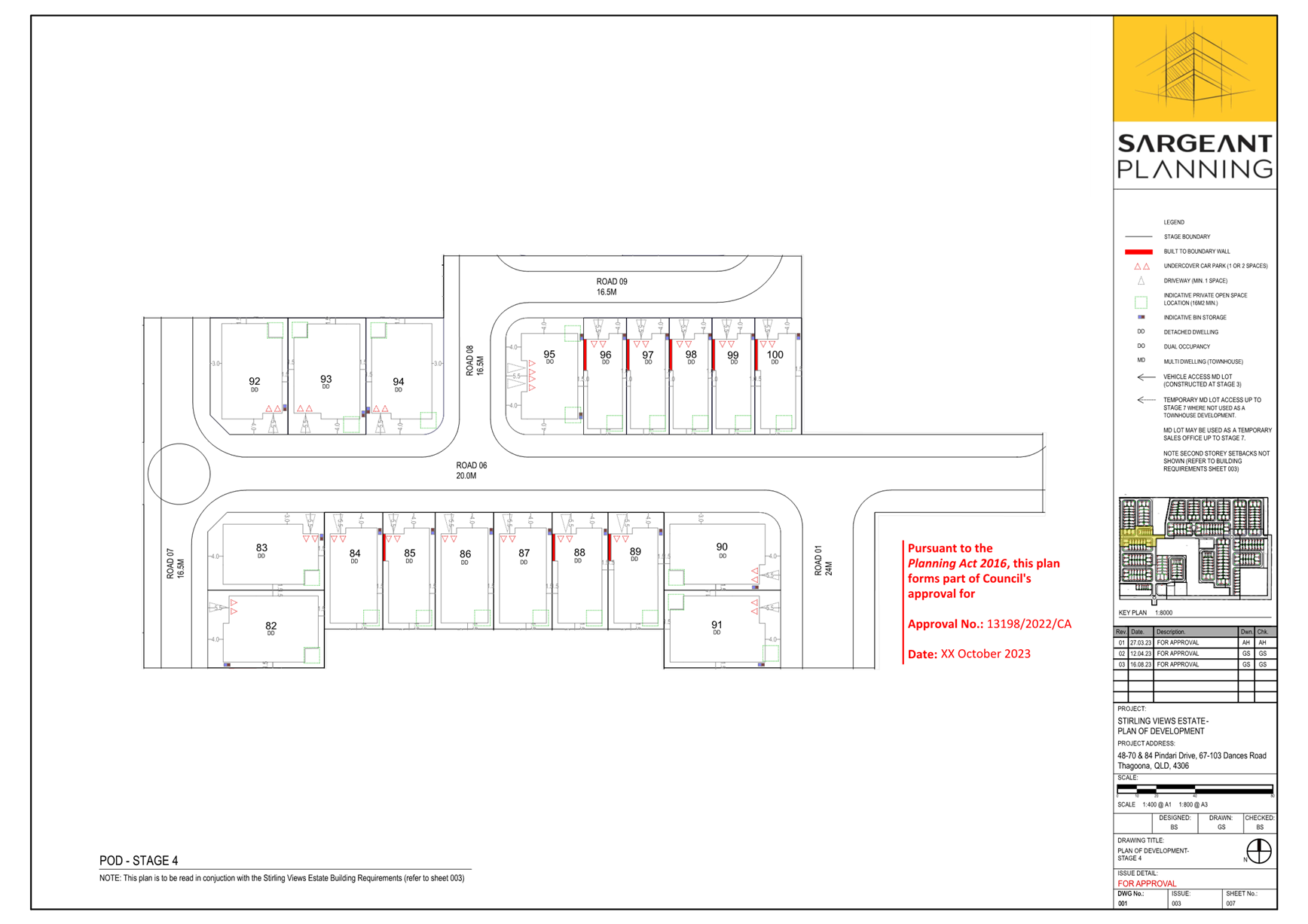
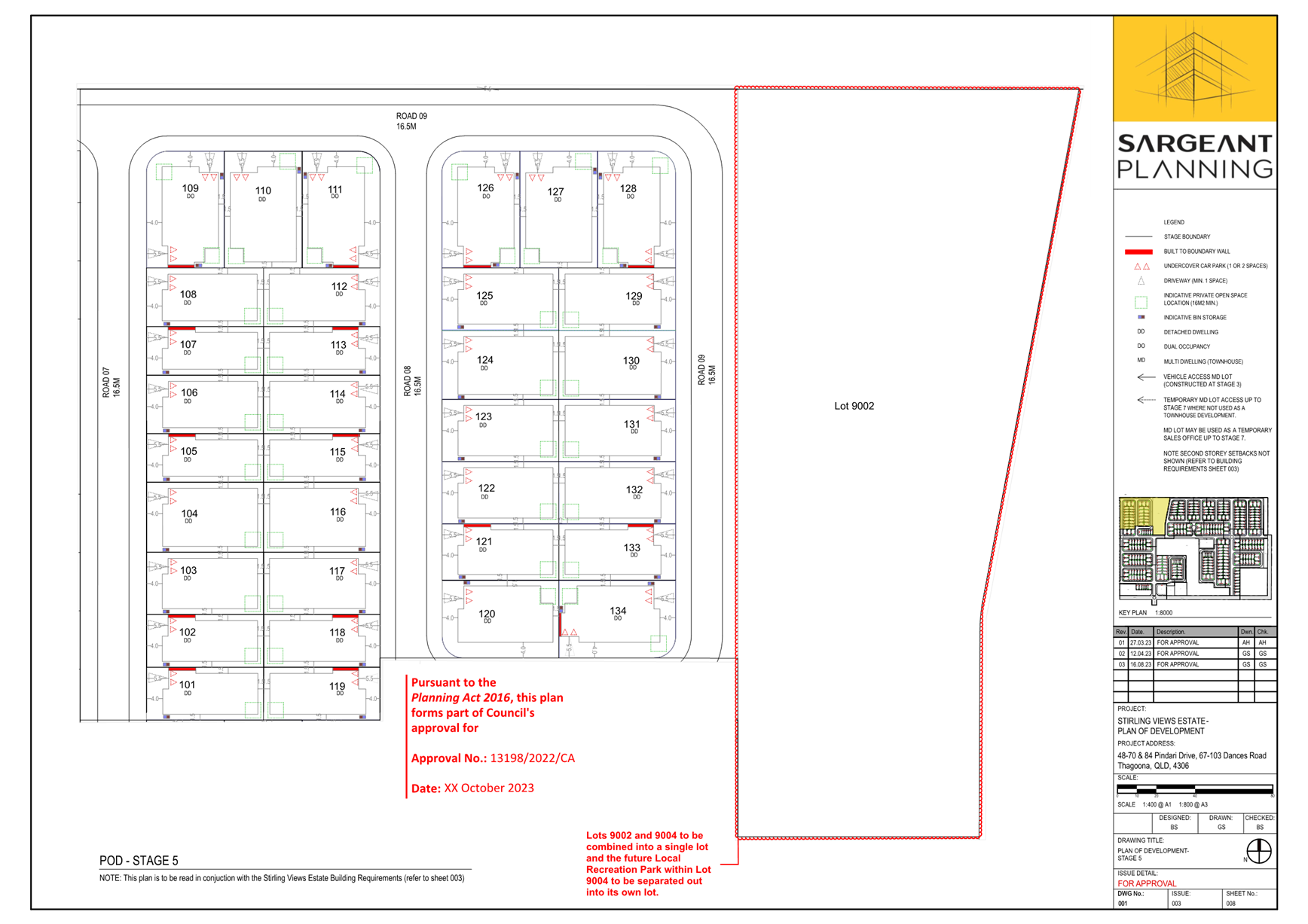
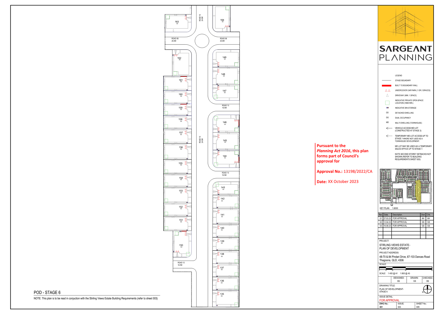
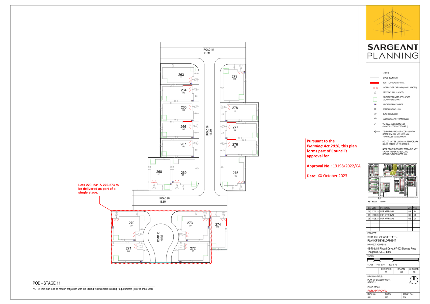
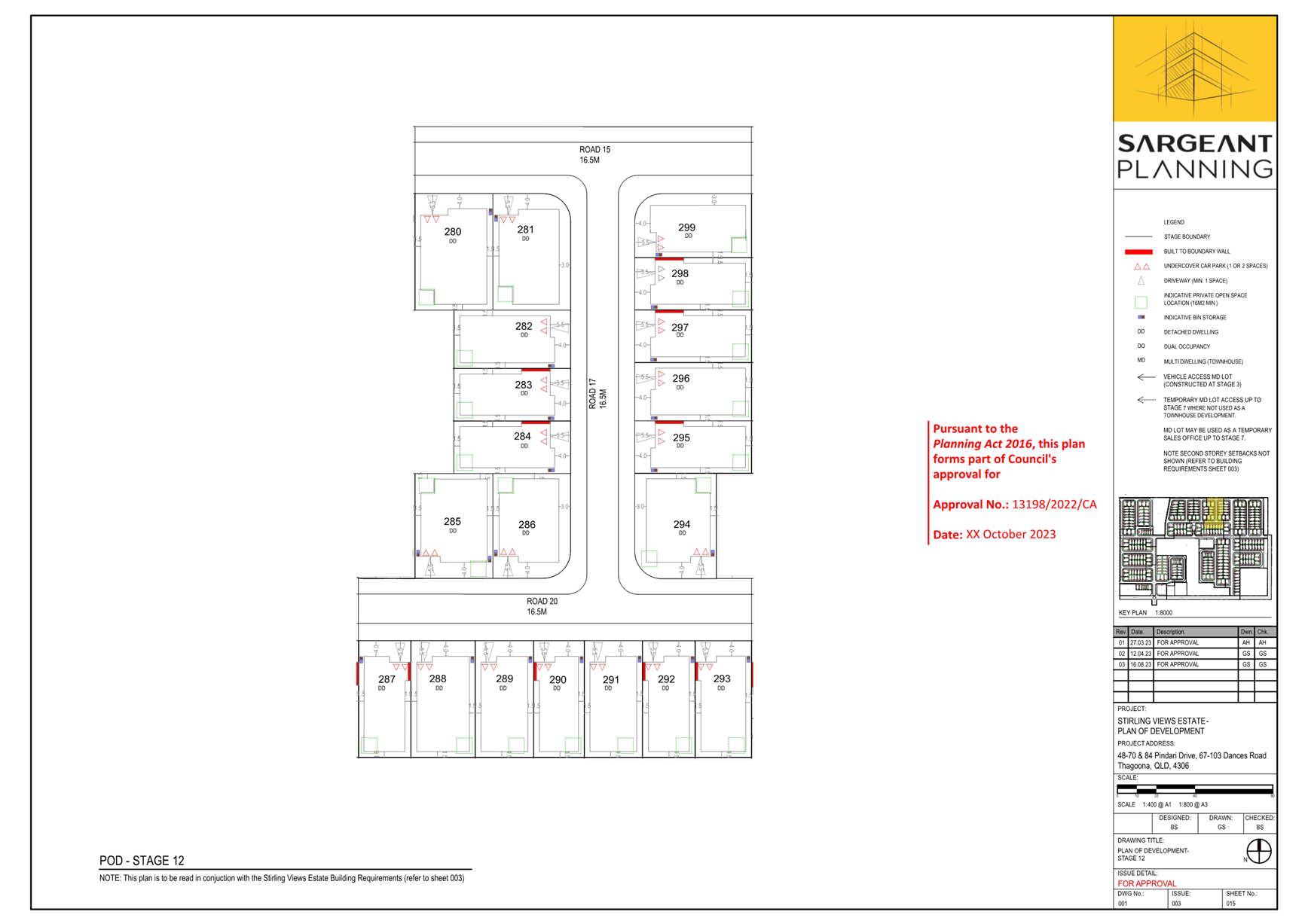
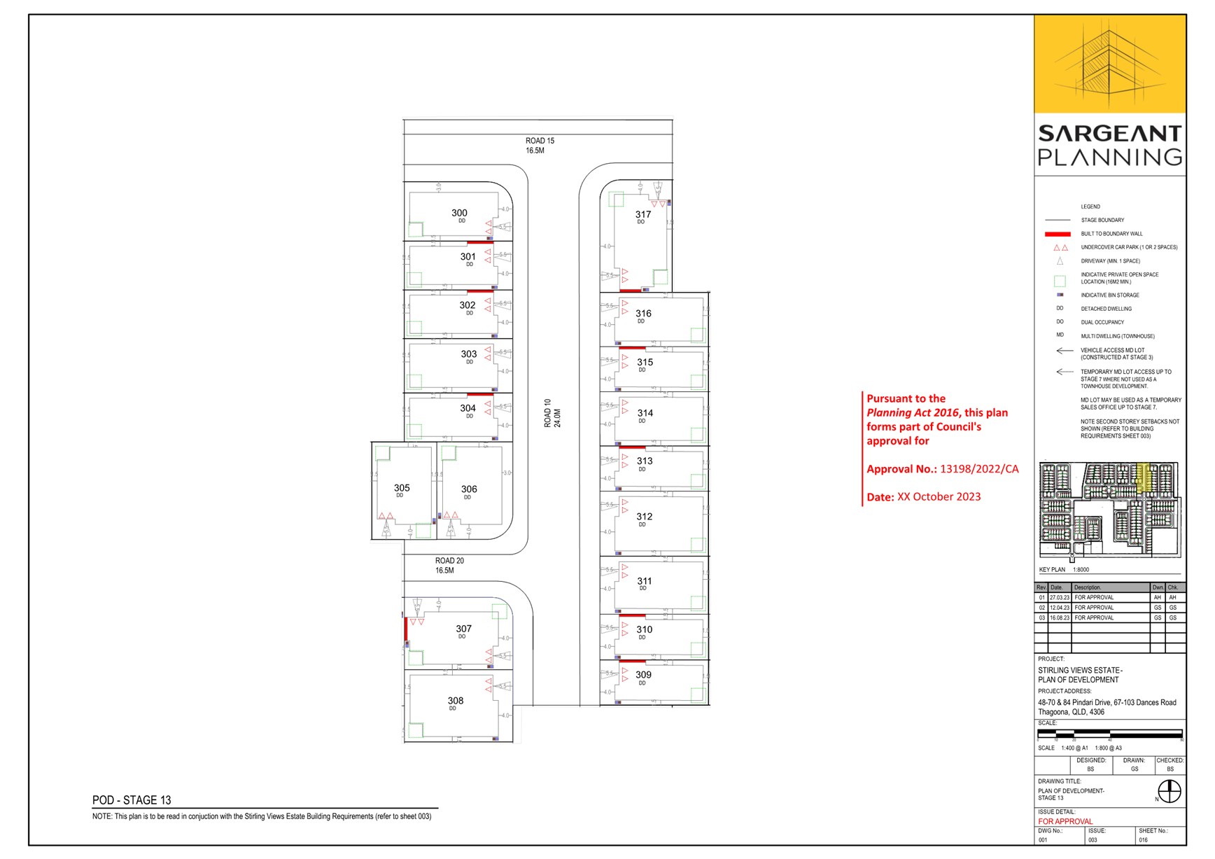
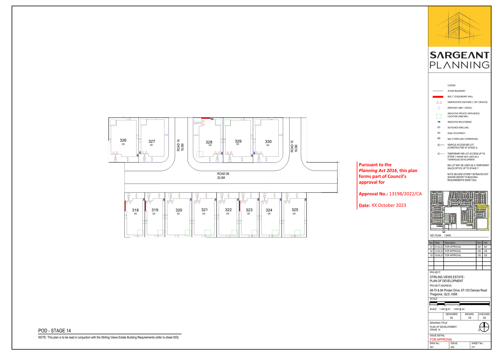
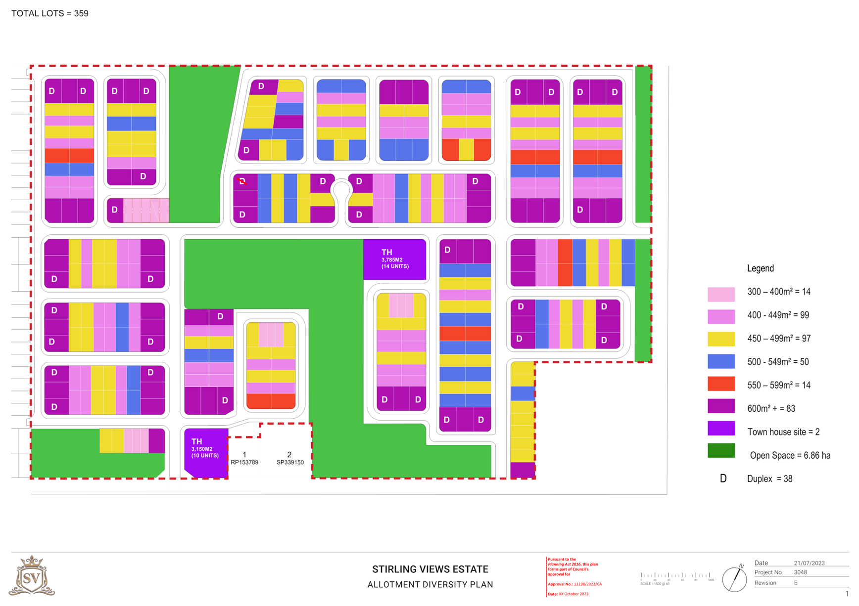
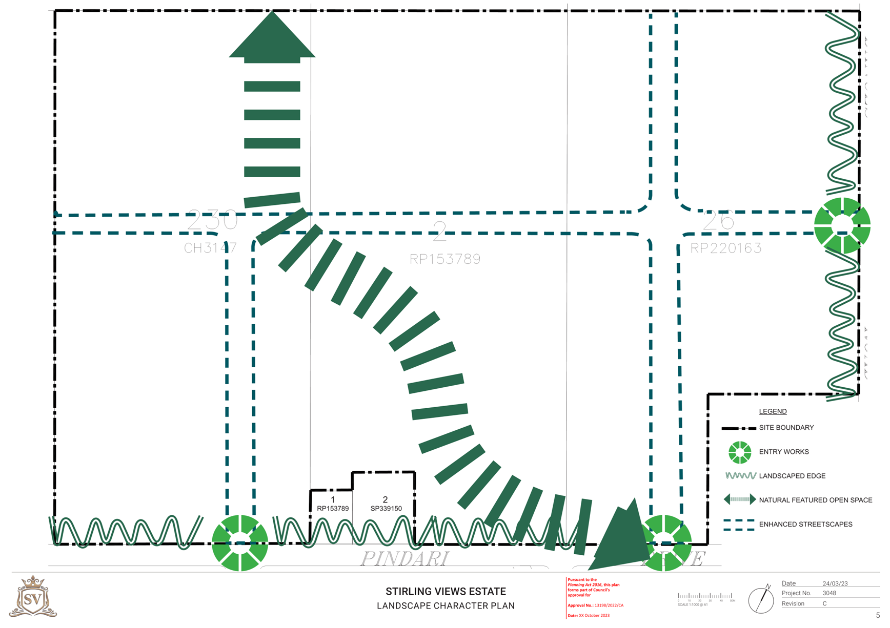
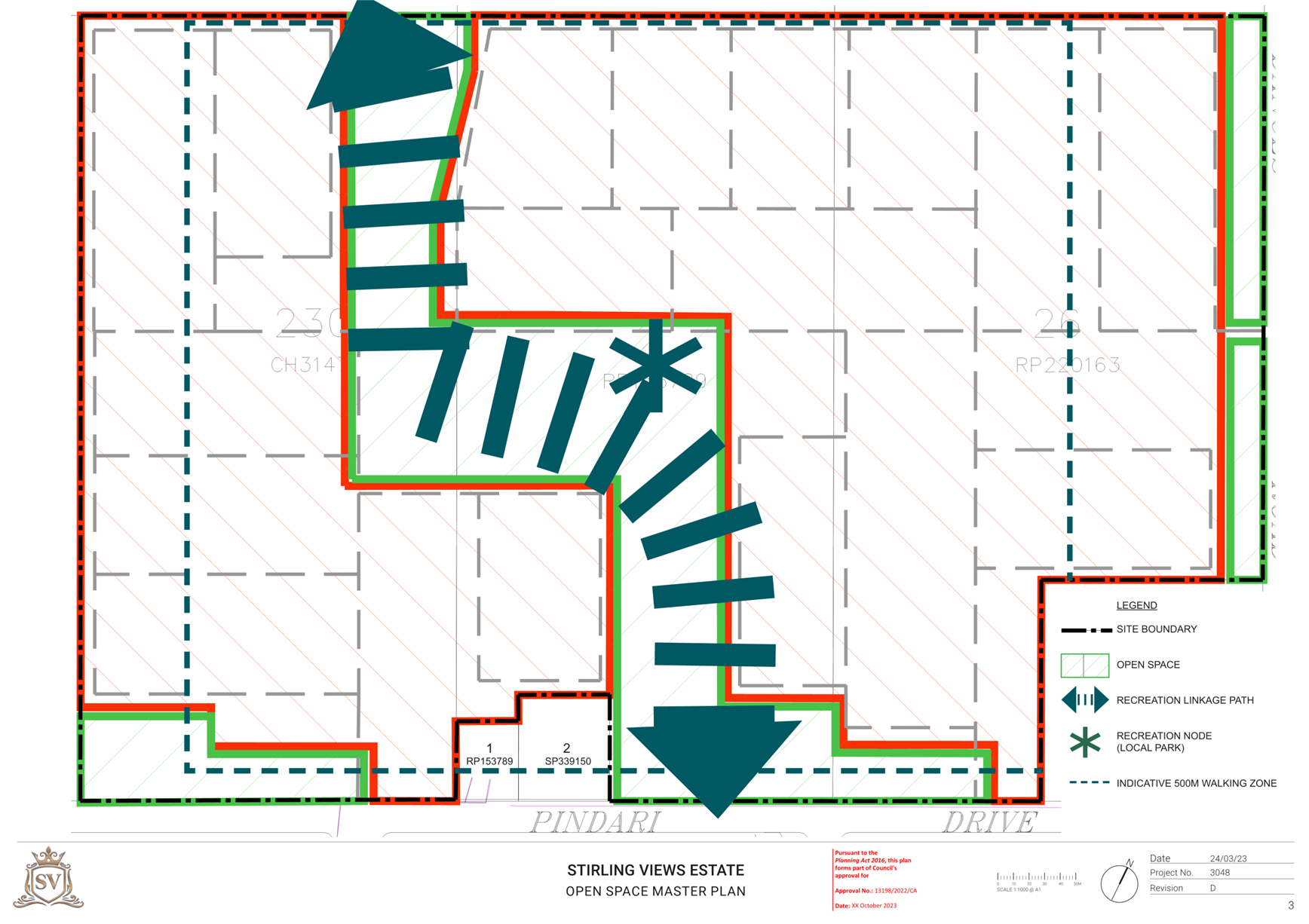
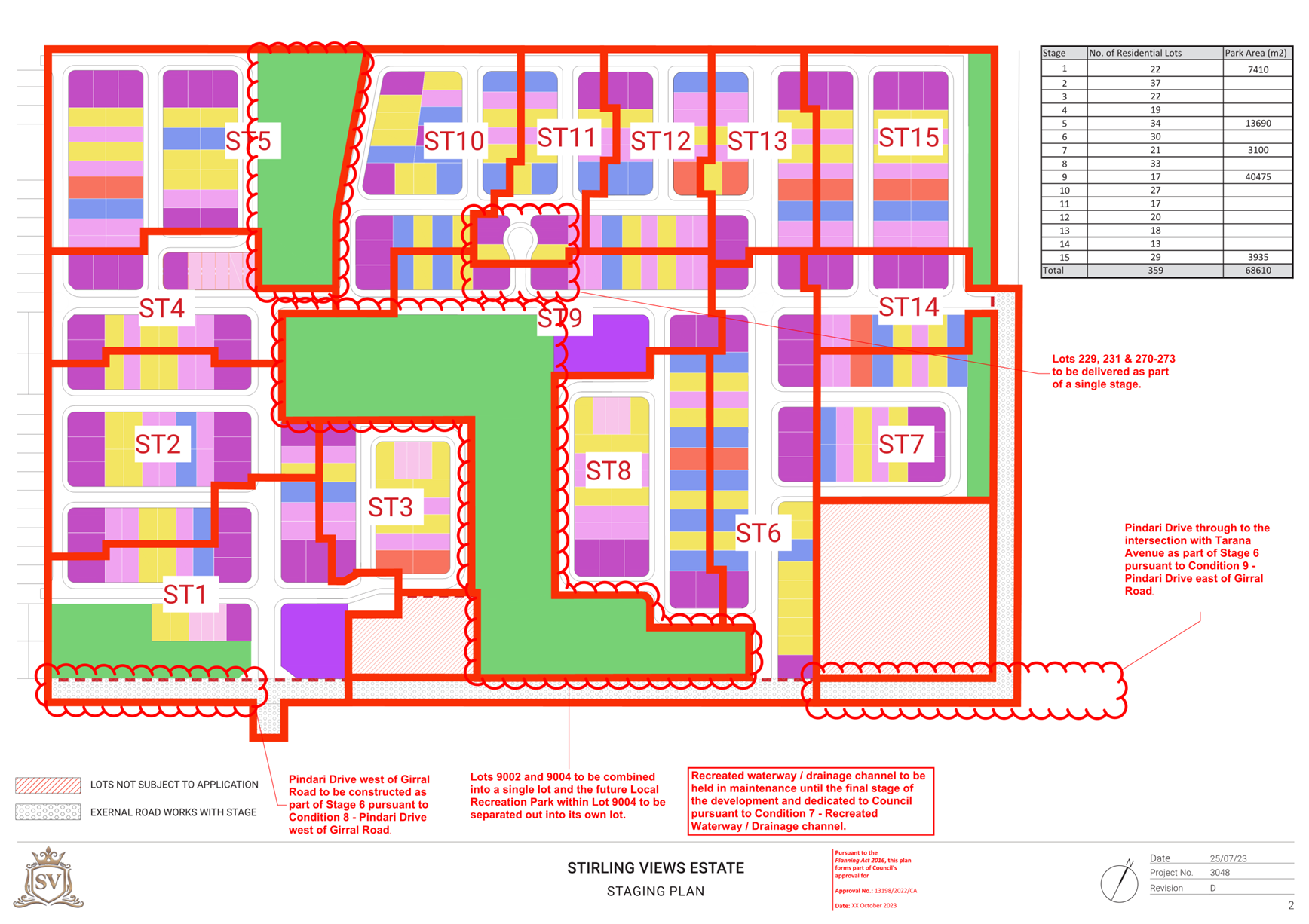
These variations are intended to complement the overall layout proposed by the applicant for the site which will see the creation of 359 residential lots across 15 stages as well as one (1) local recreation park, one (1) linear recreation park and three (3) separate drainage reserves (Figure 3 below).
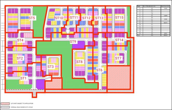
Figure 3 – Proposed Master Plan
The proposed development will include two (2) town house (multiple residential) lots in Stages 1 and 9 and 38 nominated dual occupancy lots throughout the development. The smallest proposed lot will be 300m2 (10m x 30m) and the largest will be 600m2+ (20m x 30m) in area. A summary of the typical lots and their prevalence is provided below:
|
Proposed lot sizes |
Proposed Typical Dimensions |
Number proposed |
Percentage of proposal |
|
300-400m2 |
10m x 30m |
14 |
~3.9% |
|
400-449m2 |
13.5m x 30m |
99 |
~27.6% |
|
450-499m2 |
15m x 30m |
97 |
~27% |
|
500-549m2 |
18m x 30m |
50 |
~13.9% |
|
550-599m2 |
19m x 30m |
14 |
~3.9% |
|
600m2 + |
20.5m x 30m |
83 |
~23.1% |
The smallest proposed single residential lots and the proposed dual occupancy lots are distributed throughout the development in order to minimise concentration and promote diversity and rhythm within the streetscape. They are also located close by to the proposed linear recreation park that will run through the proposed development.
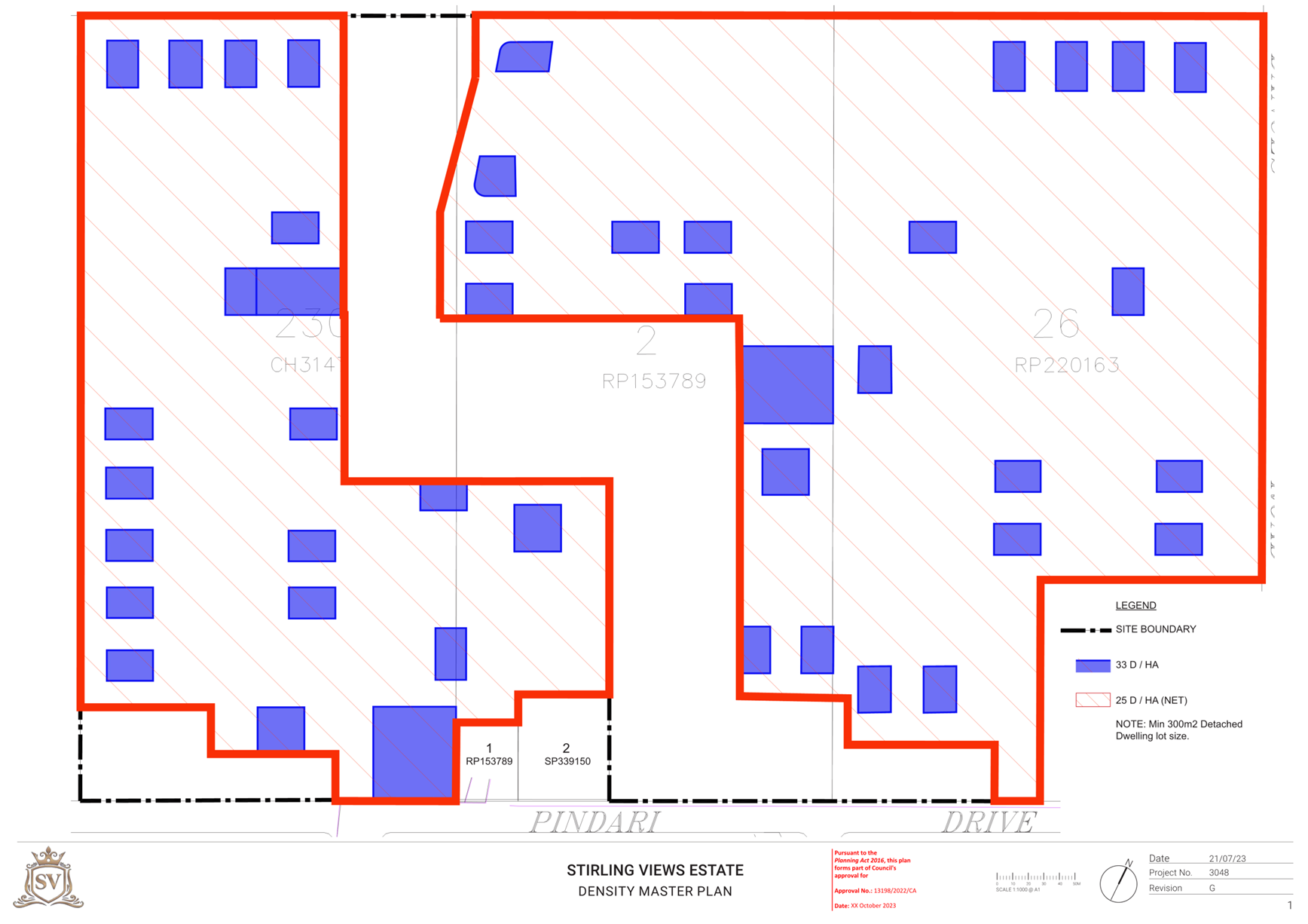
The proposed lot mix and inclusion of dual occupancy and multiple residential lots means that the proposed development will result in an overall net residential density of 15 - 25 dwellings per hectare when complete (Figure 4 below), which is consistent with the targeted densities in Shaping SEQ for new communities, which are to support a consolidated urban settlement pattern, maximise the use of existing infrastructure and deliver high quality communities.
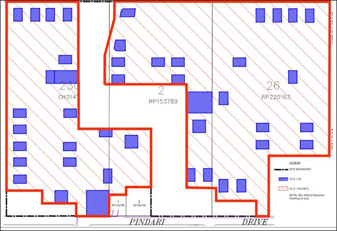
Figure 4 – Proposed Density Plan
Walloon/Thagoona Land Use Concept Master Plan (LUCMP)
The site is included in the Future Urban Zone under the Planning Scheme, and the specific intent for the Walloon/Thagoona Area within Future Urban Zone Code is articulated in the Walloon/Thagoona LUCMP. The LUCMP identifies the preferred long term urban use of the site as primarily Residential Low Density, a smaller area of Large Lot Residential in the northwestern portion of the site (consistent with the extent of the subject site included in the Large Lot Residential Zone) and an Open Space – Recreation and Drainage Area consistent with the current ephemeral waterway running through the site (Figure 5 below).
Both the current extent of land included in the Future Urban Zone in this area and the Walloon/Thagoona LUCMP under the current Planning Scheme is the result of the Walloon Thagoona Planning Study that was undertaken by the Ipswich City Council and which underwent community engagement between 2003 and 2005 before being incorporated into the current Planning Scheme in 2006. While there may have been significant change within the community since that time, the underlying intent for the area as expressed in the Strategic Framework and Local Area Framework 24 of the public consultation version of the draft Ipswich Plan 2024 has not changed.
The Future Urban Zone is intended to protect identified growth areas from fragmentation and the intrusion of incompatible uses until such time the area is developed for urban purposes, and the proposed development represents urban development for the purposes of the Future Urban Zone Code. The underlying intent for the LUCMP is the identification of an urban growth corridor that will cater for an ultimate population of approximately 42,000 people.
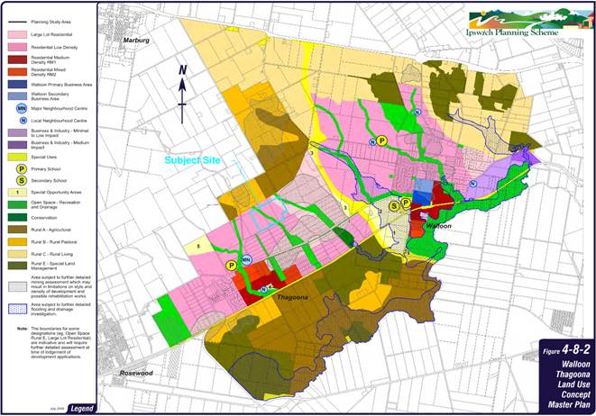
Figure 5 – Walloon/Thagoona LUCMP
The specific provisions for the Residential Low Density area within the Walloon/Thagoona LUCMP do not specify a dwelling density that must be achieved and requires only that urban uses provide for low density housing types. Elsewhere in the Planning Scheme, the maximum dwelling density specified for most areas within the Residential Low Density Zone (Sub Area RL2) is 15 dwellings per hectare. The proposed development will achieve a net residential density that exceeds this figure, however it is noted that 15 dwellings per hectare was the density metric targeted by the original and now repealed South East Queensland Regional Plan 2005-2026 for Urban Footprint areas and which has since been superseded in response to both actual and projected population growth.
It is noted that the proposed development will deliver residential development that is not consistent with Overall Outcome 4.4.2(2)(a) and Specific Outcomes 4.4.3(1)(b), (c) and (d) of the Large Lot Residential Zone Code as the dwelling density will far exceed 2.5 dwellings per hectare and none of the proposed lots will achieve a minimum area of 4,000m2 within the 38,650m2 (3.865ha) of the site that is included in the Large Lot Residential Zone. It is noted, however, that the zone boundary between the Large Lot Residential and Future Urban Zone is depicted as a ‘shifting boundary’ which is used when the final extent of a zone is to be determined as part of subsequent investigations and development application processes. In addition, it is considered the proposed development complies with the remainder of the Large Lot Residential Zone Code overall and specific outcomes as the subsequent uses will be provided with the full range of urban services and will maximise the efficient extension and safe operation of infrastructure. The proposed development also complies with all relevant overall and specific outcome of the Urban Areas Code and outcomes sought by ShapingSEQ.
Altogether, it is considered that the proposed development is consistent with the Walloon/Thagoona LUCMP. Further discussion on the relevant ShapingSEQ assessment benchmarks the application is required to be assessed against is provided below.
Dwelling Supply, density and ShapingSEQ
The site is located within the Urban Footprint as defined by ShapingSEQ, meaning that residential development and subdivision as proposed is not prohibited development. ShapingSEQ also identifies an expansion area (development occurring on land outside of the existing urban area as defined in ShapingSEQ (Figure 6 below) and formerly referred to as greenfield development), dwelling target for the whole of the Ipswich local government area from 39,946 in 2016 to 43,000 by 2031 and 83,800 by 2041.
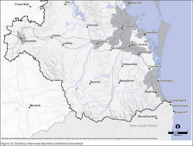
Figure 6 – ShapingSEQ Existing Urban Area
It is noted that while ShapingSEQ is currently being reviewed and that a draft is currently available for public comment, the relevant assessment benchmarks in Chapter 3 Part A and Part C remain in force. While not yet final, the policy and outcome settings for this part of the City do not appear to be proposed to change in any meaningful way. It is also noted that the proposed development is located outside of the defined Existing Urban Area and so is located within the Ipswich expansion area.
The benchmarks as they relate to the proposed development require efficient accommodation of the region’s growth needs within the Urban Footprint, planning for a net residential density of 15-25 dwellings in new communities, maximising the variety of available land in suitable locations to support a range of housing choices under a range of market and economic circumstances and ensuring the planning and delivery of land use and infrastructure for new communities are integrated and sequenced and deliver complete communities in a timely manner. The benchmarks also require the delivery of new and more complete communities that are well-planned and serviced in Rosewood/Walloon/Thagoona.
Altogether, it is considered that the proposed development complies with relevant ShapingSEQ assessment benchmarks including:
- Chapter 3, Part A, Goal 1, Element 1, Strategies 1, 2 and 3;
- Chapter 3, Part A, Goal 1, Element 3, Strategies 1 - 3;
- Chapter 3, Part A, Goal 1, Element 4, Strategies 1-4;
- Chapter 3, Part A, Goal 3, Element 1, Strategy 1;
- Chapter 3, Part A, Goal 3, Element 2, Strategy 4;
- Chapter 3, Part A, Goal 3, Element 5, Strategy 1;
- Chapter 3, Part A, Goal 4, Element 7, Strategies 1, 2 & 4;
- Chapter 3, Part A, Goal 4, Element 8, Strategy 1;
- Chapter 3, Part A, Goal 4, Element 10, Strategies 1-4;
- Chapter 3, Part A, Goal 4, Element 11, Strategies 1, 2 & 4; and
- Chapter 3, Part C, Western sub-regional outcome 2g.
State Planning Policy Part E Assessment Benchmarks – Natural Hazards, risk and resilience (Bushfire)
The site is not identified on Planning Scheme overlay OV1 – Bushfire Risk Areas but is identified on the State Planning Policy (SPP) Development Assessment Mapping System (DAMS) as containing areas of High and Medium Potential Bushfire Intensity and Potential Impact Buffer bushfire hazard – bushfire prone areas (Figure 7 below).
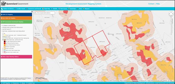
Figure 7 – SPP DAMS Mapping for Natural Hazards, Risk and Resilience
As the SPP State Interest – Natural Hazards, Risk and Resilience is not identified in the planning scheme as being appropriately integrated into the Ipswich Planning Scheme 2006 the relevant assessment benchmarks in Part E of the SPP apply to the proposed development. These include:
(3) Development … avoids natural hazard areas, or where it is not possible to avoid the natural hazard area, development mitigates the risks to people and property to an acceptable or tolerable level.
(4) Development supports and does not hinder disaster management response or recovery capacity and capabilities.
(5) Development directly, indirectly and cumulatively avoids an increase in the severity of the natural hazard and the potential for damage on the site or to other properties.
(7) The natural processes and the protective function of landforms and the vegetation that can mitigate risks associated with the natural hazard are maintained or enhanced.
The proposed development will result in the removal of the vegetation constituting the bushfire hazard areas within the site boundaries and the Pindari Road road reserve but identified vegetation outside of these areas will remain. This will mean areas of proposed Stages 1, 2, 4, 5 will be affected by the 100m Potential Impact Buffer distance to vegetation that will remain adjacent to the site and proposed development.
The applicant has submitted a Bushfire Hazard Assessment prepared by a suitably qualified and experienced person as outlined in section 10.2 of Bushfire Resilient Communities Technical Reference Guide for the State Planning Policy State Interest ‘Natural Hazards, Risk and Resilience – Bushfire 2019.
The Bushfire Hazard Assessment (BHA) evaluates the vegetation classification, the distance between the vegetation and the proposed development and and terrain characterising the likely areas of hazardous vegetation that will remain outside of the site and determines that of all the proposed residential lots within proposed Stages 1, 2, 4 and 5 only those houses fronting the proposed permieter roads will be subject to risk from the adjoining hazardous vegetation at a Building Attack Level (BAL) of 12.5. This will be appropriately addressed at the time subsequent houses are built due to the mandatory requirements of of the National Construction Code and Australian Standard 3959:2018 Construction of buildings in bushfire prone areas, and has also been included as a recommended condition (Condition 6 – Bushfire Safety) for the Preliminary Approval component of this application.
The BHA also notes that extending the reticulated water network and local road network into the proposed development and providing perimiter access roads will increase the capacity of fire services to respond to any potential bushfires in the surrounding areas that may affect the proposed development. Accordingly, it is considered the proposed development complies with the relevant SPP Part E assessment benchmarks for Natural hazards, risk and resilience (Bushfire).
Future orderly development
The Future Urban Zone Code requires that proposed development clearly indicate how it would facilitate, and not unduly impact on, the ability of adjoining and adjacent land to support urban development consistent with the Walloon/Thagoona LUCMP. The applicant has submitted an indicative future orderly development plan indicating how the proposed layout, internal road network and open space will integrate with the surrounding area such that adjoining and adjacent properties will be able to support future urban development in a manner consistent with the LUCMP (Figure 8 below). It should be noted that this plan will not form part of an approval if granted and is required only to demonstrate that there will be no adverse impacts on the development potential of adjoining properties and the surrounding area. Further detailed assessment of the suitability of the plan will occur in conjunction with assessment of applications on these surrounding properties.
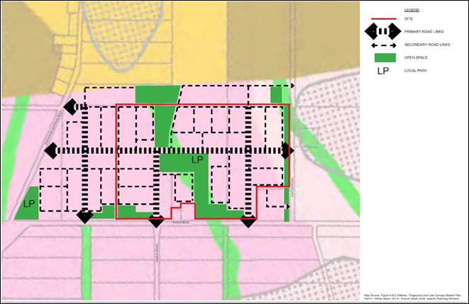
Figure 8 – Indicative Future Orderly Development
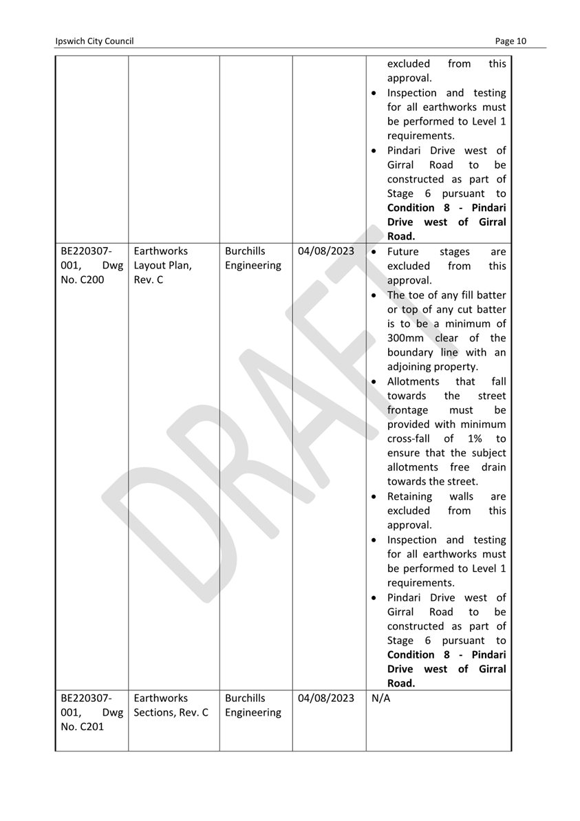
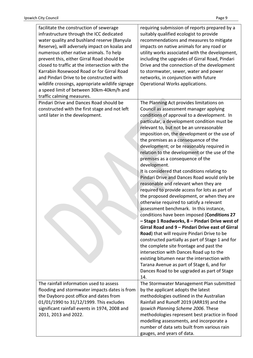
In addition, conditions are recommended for inclusion (Conditions 12 – Roadworks – Pindari Drive Design and 27 – Stage 1 Roadworks) requiring that the new roads that will interface with adjoining and adjacent properties will be designed and constructed to minimise impacts on later development. As such, it is considered the proposed development has demonstrated how it will facilitate the future orderly development of the adjoining area.
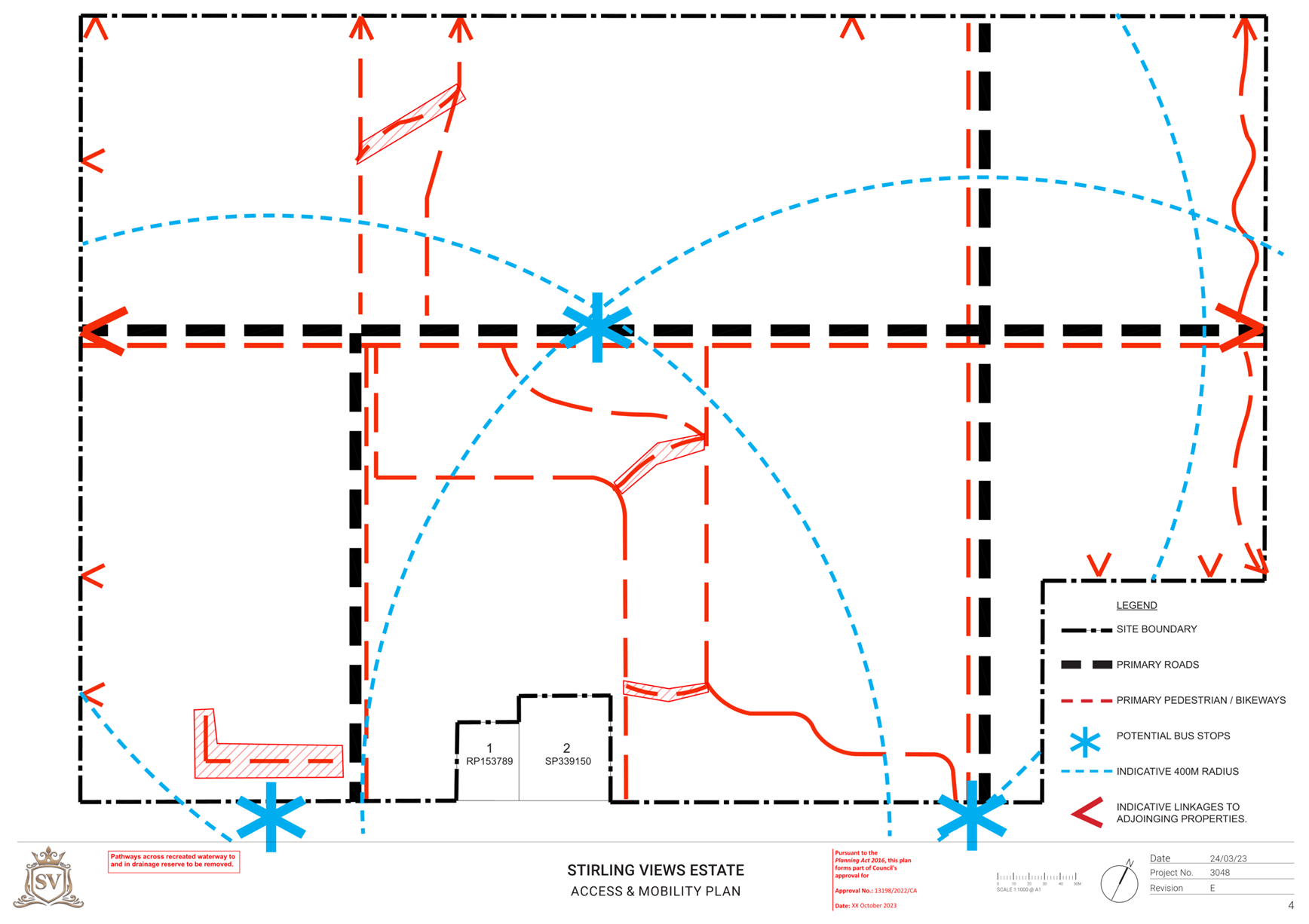
Road works and transport
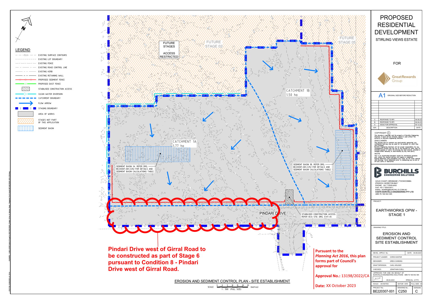
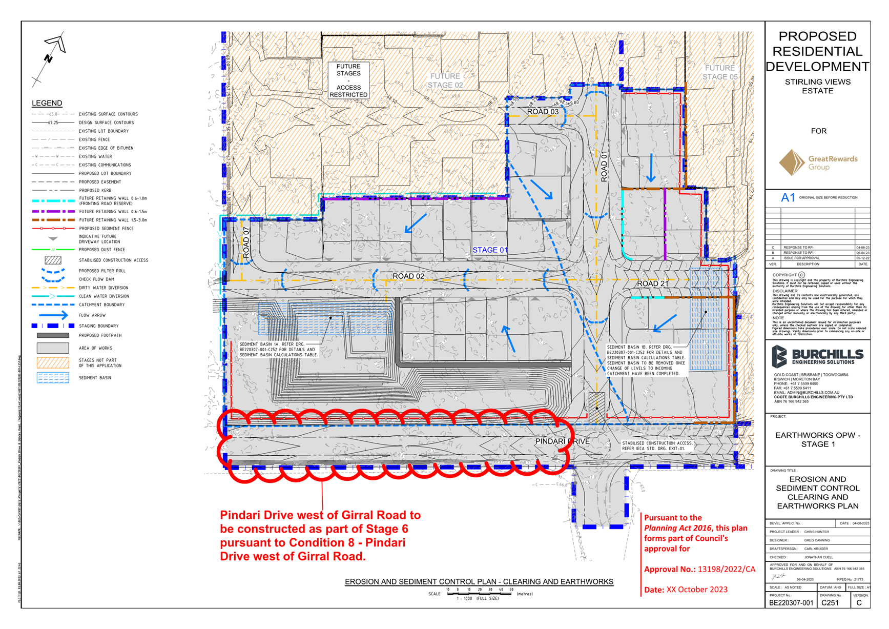
Only approximately 120m of Pindari Drive fronting the development site is currently constructed and maintained by Council as a gravel road with the rest of the Pindari Drive, and all of Dances Road fronting the site, currently unformed. Girral Road, which forms the main access spine into the development site, is also currently not in a state sufficient to support the new urban neighbourhood. The applicant has submitted a Traffic Impact Assessment detailing the following upgrades to the external road network in order to facilitate the proposed development:
- Upgrading of Girral Road to a residential collector standard from the intersection of Pindari Drive through to the intersection with the State-controlled Karrabin Rosewood Road as part of Stage 1;
- Upgrading of Pindari Drive to a residential collector standard for the site frontage to the west of the intersection with Girral Road, from intersection of Girral Road up to approximately 56m east of proposed Road 01 as part of Stage 1, from the intersection with proposed Road 01 road up to approximately 33m east of proposed Road 10 as part of Stage 6 and then up to the intersection with Dances Road as part of Stage 14 (refer to Figure 3 above and Figure 9 below);
- Upgrading of Dances Road to a rural collector standard from the intersection of Pindari Drive up to proposed Road 06 as part of Stage 14; and
- Upgrading the Girral Road/Karrabin Rosewood Road and Tarana Avenue/Karrabin Rosewood Road intersections as part of Stages 1 and 14 respectively (for more details refer to the Referral Agency section below).
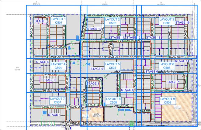
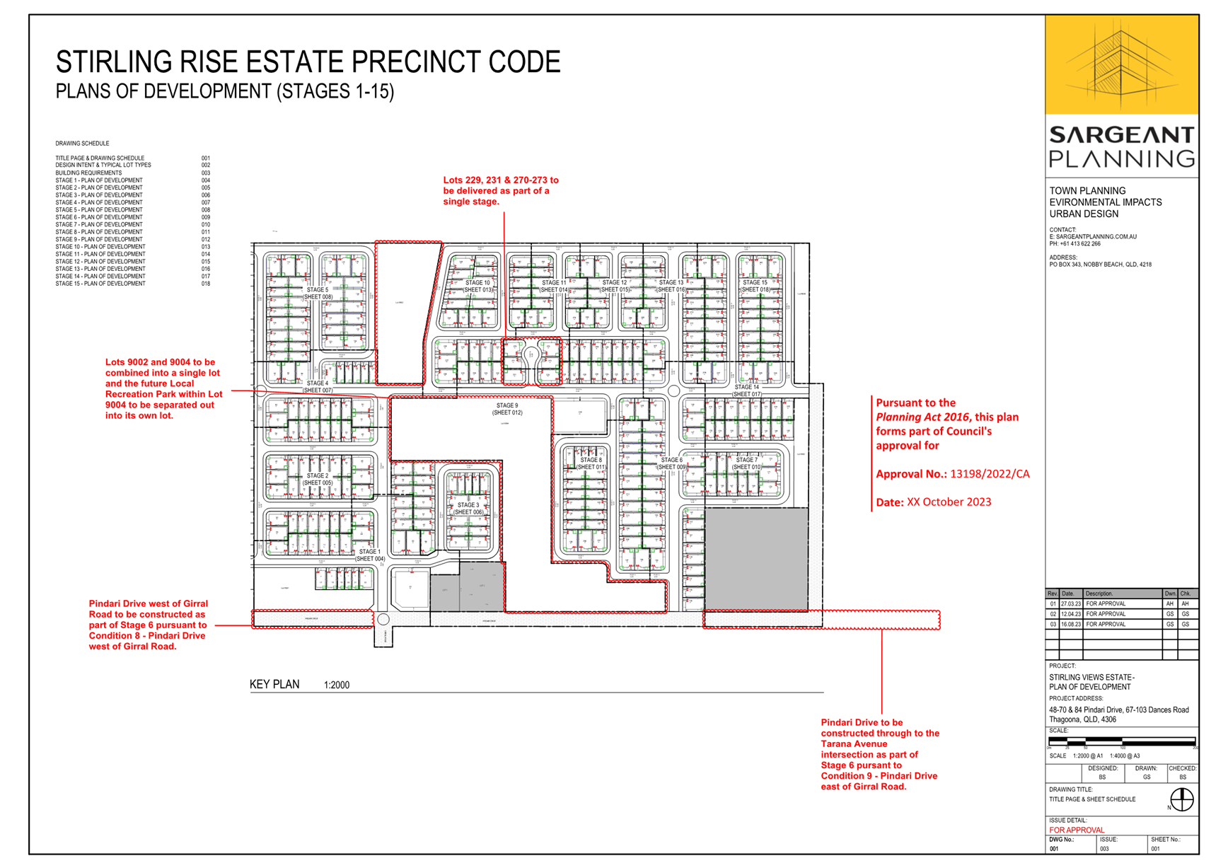
Figure 9 – Proposed internal road layout and numbering
The upgrade of Pindari Drive to the west of the intersection with Girral Road is required in order to achieve the Strategic Road Network identified in the Walloon/Thagoona LUCMP (Figure 10 below), but as there are currently no active development applications or existing approvals located to the west of the site a condition is recommended for inclusion (Condition 8 – Pindari Drive west of Girral Road) requiring that this section be upgraded as part of proposed Stage 6 as opposed to Stage 1 to ensure that all necessary frontage works will be delivered in an integrated manner as part of the proposed development within a realistic, but not premature, timeframe.
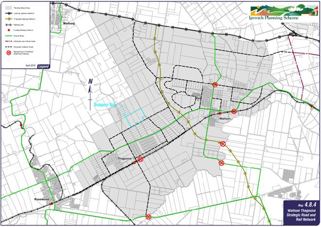
Figure 10 – Strategic Road network
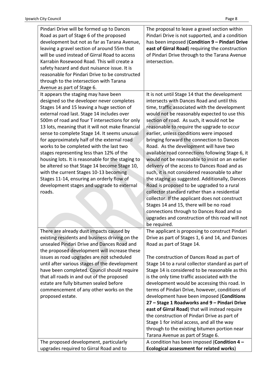
It is noted, however, that the applicant is proposing not to upgrade Pindari Drive up to the intersection with Dances Road until Stage 14 and is not proposing to extend the upgrades to the east where it would connect with an existing bitumen section near the intersection with Tarana Avenue. This would leave approximately 47m of gravel road within Pindari Drive, which and is not considered to be practical or appropriate. In addition, the Reconfiguring a Lot Code requires that all precincts including more than 100 lots are provided with an alternative street access, particularly those subject to bushfire risk. As such, a condition is recommended for inclusion (Condition 9 – Pindari Drive east of Girral Road) requiring that Pindari Drive be upgraded all the way through to the intersection with Tarana Avenue as part of Stage 6.
The upgrade of Dances Road up to the intersection of proposed Road 06 is considered to be appropriate, however it is noted the applicant intends for it only to be a rural collector standard. Consistent with the requirements of the Reconfiguring a Lot Code and Council’s Standard Drawing SR.09 a rural collector is a bitumen sealed, two-lane road with a minimum 9m formation and a nominal pavement width of 7m servicing a maximum of 165 lots and having a maximum traffic volume of 1,000 vehicles per day. While no footpaths are provided for a rural collector, it is noted that neither Dances Road nor Tarana Avenue form part of the Strategic Pedestrian/Cycleway Network identified in the Walloon/Thagoona LUCMP (Figure 11 below). Given the remaining properties fronting the eastern side of Dances Road within the Urban Footprint are subject to impacts of underground mining and are currently zoned Large Lot Residential, and those further north are located outside of the Urban Footprint and not able to be subdivided under the current planning framework, it is considered the proposed rural collector standard will be acceptable for the traffic generated by the eastern stages of the proposed development. It is noted that irrespective of this approval, future development applications on properties not subject to this application which front this section of road will also need to address the suitability of the road standard to service the respective developments.
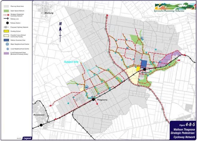
Figure 11 – Strategic Pedestrian/Cycleway Network
Pindari Drive, Girral Road and the identified open space network are the nominated pedestrian and cycleway routes, and conditions requiring their delivery will be imposed as part of subsequent development permits for each relevant stage.
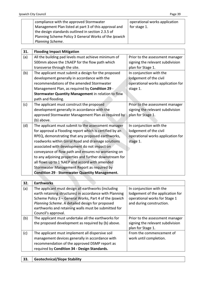
Flood impacts
The site is not identified on Planning Scheme overlay OV5 – Flooding and Urban Catchment Flow Paths but parts of the land, primarily the central waterway corridor, are subject to inundation up to and including a 1% Annual Exceedance Probability (AEP) event in the 2019 update to Council’s Thagoona Area Flood Study 2012 (Figure 12 below).
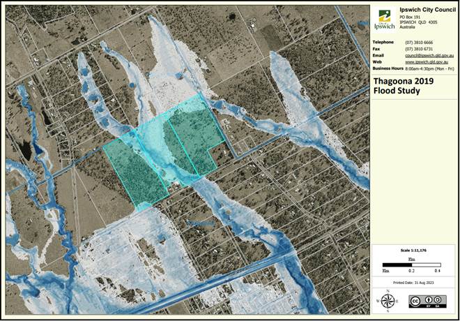
Figure 12 – 1% AEP Flood Model extent from 2019 update to Thagoona Area Flood Study 2012
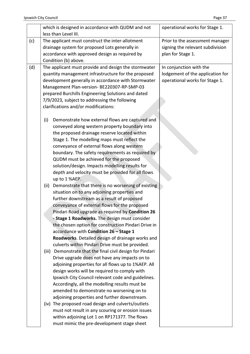
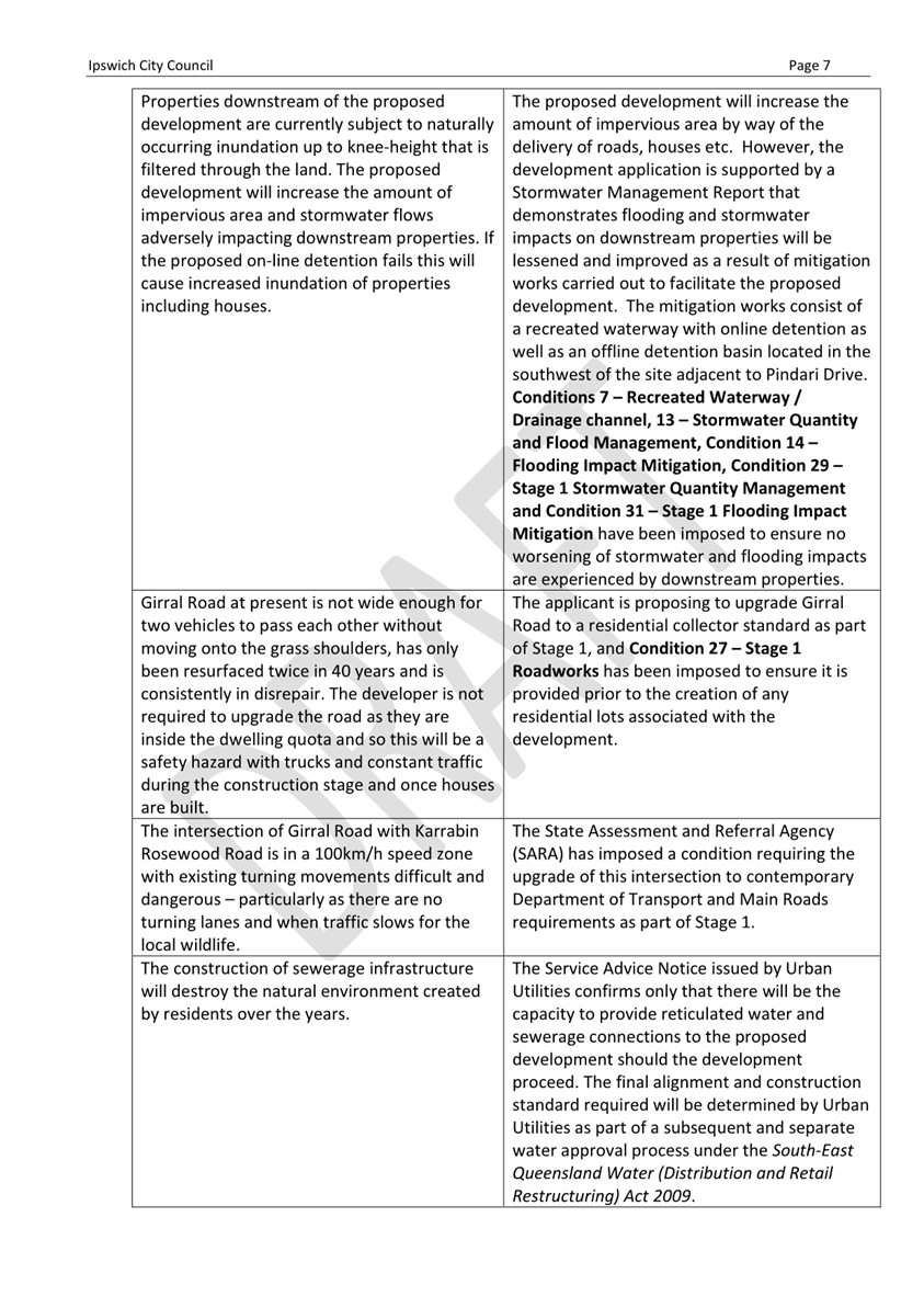
The applicant has provided a detailed Stormwater Management Report that details how the proposed development will deal with both upstream flows and increased concentration as a result of the proposed development to ensure neither adjoining, downstream or upstream properties or the proposed residential development itself will be adversely impacted.
The site contains an existing ephemeral first order waterway that traverses the site roughly north-south. It is more defined at the western portion of the site and is characterised more as sheet flow in the eastern extents. The proposed development will see earthworks undertaken that will redirect flows across the northern boundaries of the site and channel them into a proposed 60m- wide recreated channel (Figure 13 below).
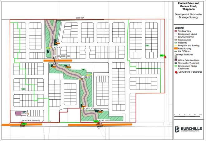
Figure 13 – Proposed recreated channel
The recreated channel will contain a series of on-line (within the waterway) detention basins designed to slow the movement of water through the recreated channel so that the volume and velocity of the water leaving the site does not adversely impact downstream properties and is maintained to no more than the pre development flows. This channel will also include local linear park and is intended to be planted so that a far improved vegetated, naturalised outcome is achieved. The inundation characteristics of the proposed cross-channel pedestrian links associated with the in-stream bunds are not, however, supported and approved plans and documents will need to be amended to reflect their removal.
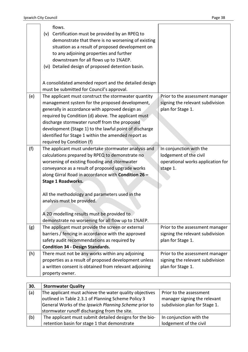
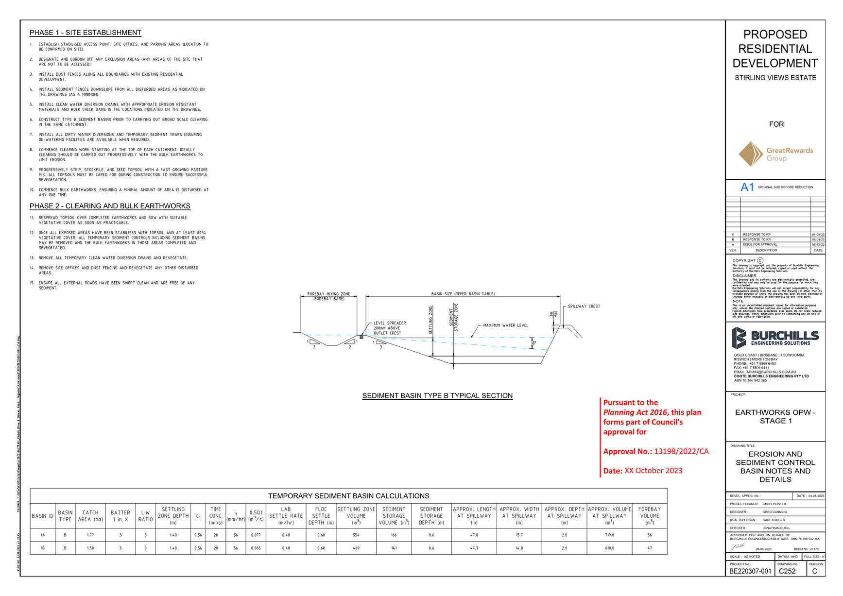
The report demonstrates that, as a result of the proposed development, there will be no worsening of flood and stormwater impacts for downstream properties and even demonstrates improvements for downstream properties currently modelled as being affected by inundation during a 1% AEP event by way of reduced afflux as a result of the works associated with the development (Figure 14 below). Conditions are recommended for inclusion (Conditions 7 – Recreated Waterway / Drainage channel, 13 – Stormwater Quantity and Flood Management, Condition 14 – Flooding Impact Mitigation, Condition 29 – Stage 1 Stormwater Quantity Management and Condition 31 – Stage 1 Flooding Impact Mitigation Condition) to ensure that the works to create the channel and ensure improved outcomes are delivered as part of Stage 1 of the proposed development.
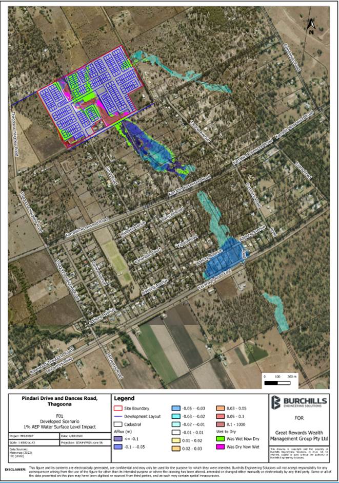
Figure 14 – Modelled 1% AEP flood and stormwater water surface level extent as result of proposed development
Integrated planning, uses and works
The Urban Areas Code and Future Urban Zone Code both require that development be serviced by appropriate infrastructure including water supply, sewer systems, roads, footpaths, parks and community services. The Future Urban Zone Code in particular requires that urban development is provided with the appropriate infrastructure to support new communities in a timely and integrated fashion.
The applicant has provided a Services Advice Notice (SAN) from Urban Utilities that confirms reticulated water and sewerage will be provided to the proposed development. A SAN is not a works approval, and the applicant will still need to separately obtain a water approval from Urban Utilities under the South-East Queensland Water (Distribution and Retail Restructuring) Act 2009. The final form and alignment of the water and sewer connections between Urban Utilities’ existing networks and the proposed development will be determined as part of this separate approval process, and conditions of this approval require the connections to be in place prior to Council signing any future subdivision plan to create the lots.
In addition to the internal roads required to be constructed as part of the proposed development, upgrades to the surrounding local road network will also be required along Girral Road, Pindari Drive, Dances Road and Tarana Avenue. These works are discussed in more detail below in the Roadworks and transport section. The proposed development will also require upgrades to the State-controlled Karrabin Rosewood Road at the intersections of Girral Road and Tarana Avenue. These works are discussed in more detail below in the Referral Agency section.
The Walloon/Thagoona LUCMP includes two proposed centres within the Thagoona area including a Major Neighbourhood Centre (MNC) at the corner of Karrabin Rosewood Road and Thagoona Haigslea Road and a Local Neighbourhood Centre (LNC) further along Thagoona Haigslea Road closer to the train station in the vicinity of Loder Road (Figure 5 above). These centres are identified consistent with the Planning Scheme’s Centres Hierarchy and Strategy as outlined in Schedule 7 and are intended, along with the Walloon Primary and Secondary Business Areas and three (3) more Local Neighbourhood Centres, to provide retail and other community and government services commensurate with the expected residential population within the LUCMP area. Consistent with the Future Urban Zone Code, MNCs are intended to serve between 5,000 and 15,000 people and provide between 2,000m2 and 6,000m2 of floor space. A LNC, on the other hand, is intended to have up to 2,000m2 of floor space and to serve a localised catchment of up to 5,000 people.
While there are currently no retail, community or other services close to the proposed development, Council has received and is currently assessing a development application for the MNC located at the corner of Karrabin Rosewood Road and Thagoona Haigslea Road (127/2023/CA). This centre, if approved, will be located around 1.5km travel distance from the proposed development via Girral Road and Karrabin Rosewood Road. Irrespective of the trajectory of the MNC application, as population increases it is expected that demand will see the need for the identified centres increase and so it is considered the full range of urban services necessary to support a new community can be available within a realistic timeframe.
It should also be noted that the LUCMP identifies a new primary school site located adjacent to the MNC (Figure 5 above). The final decision on the timing, location and size of schools rest with either the Queensland Department of Education or private school operators and Council has limited involvement and influence. However, in 2019 the Queensland Schools Planning Reference Committee (QSPRC) – Cross-Sectoral New Schools Demand Mapping 2021 to 2041 for Ipswich City Council identified that 1-2 new primary and 1-2 new secondary schools (government and non-government) would be required by 2031 in the Rosewood Statistical Area Level 2 (SA2) – an area which includes the proposed development (Figure 15 below)
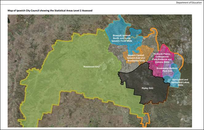
Figure 15 – SA2 areas assessed in QSPRC New School Demand Mapping 2019
Accordingly, it is considered the proposed development demonstrates that it will be planned and constructed in a way that appropriately integrates with necessary infrastructure and services and so is consistent with the relevant requirements of the Urban Areas Code and Future Urban Zone Code.
Stormwater Impacts
The applicant has provided a Stormwater Management Plan that demonstrates the proposed development will not result in adverse impacts on adjoining, upstream or downstream properties by way of the increased stormwater quantity associated with the proposed development. The proposed development will achieve this by providing a series of detention basins within the recreated waterway that will slow the movement of water through the site and ensure that stormwater discharges are maintained to pre development flows.
In terms of achieving Planning Scheme water quality objectives, the applicant is proposing a series of bio-retention basins throughout the development and also the subsequent installation and maintenance of 4,000L rainwater tanks for each lot. The requirement for rainwater tanks is part of the proposed Plan of Development, and a condition is also recommended for inclusion (Condition 5 – Rainwater Tanks) to reinforce the requirement for subsequent residential development to provide and maintain the tanks.
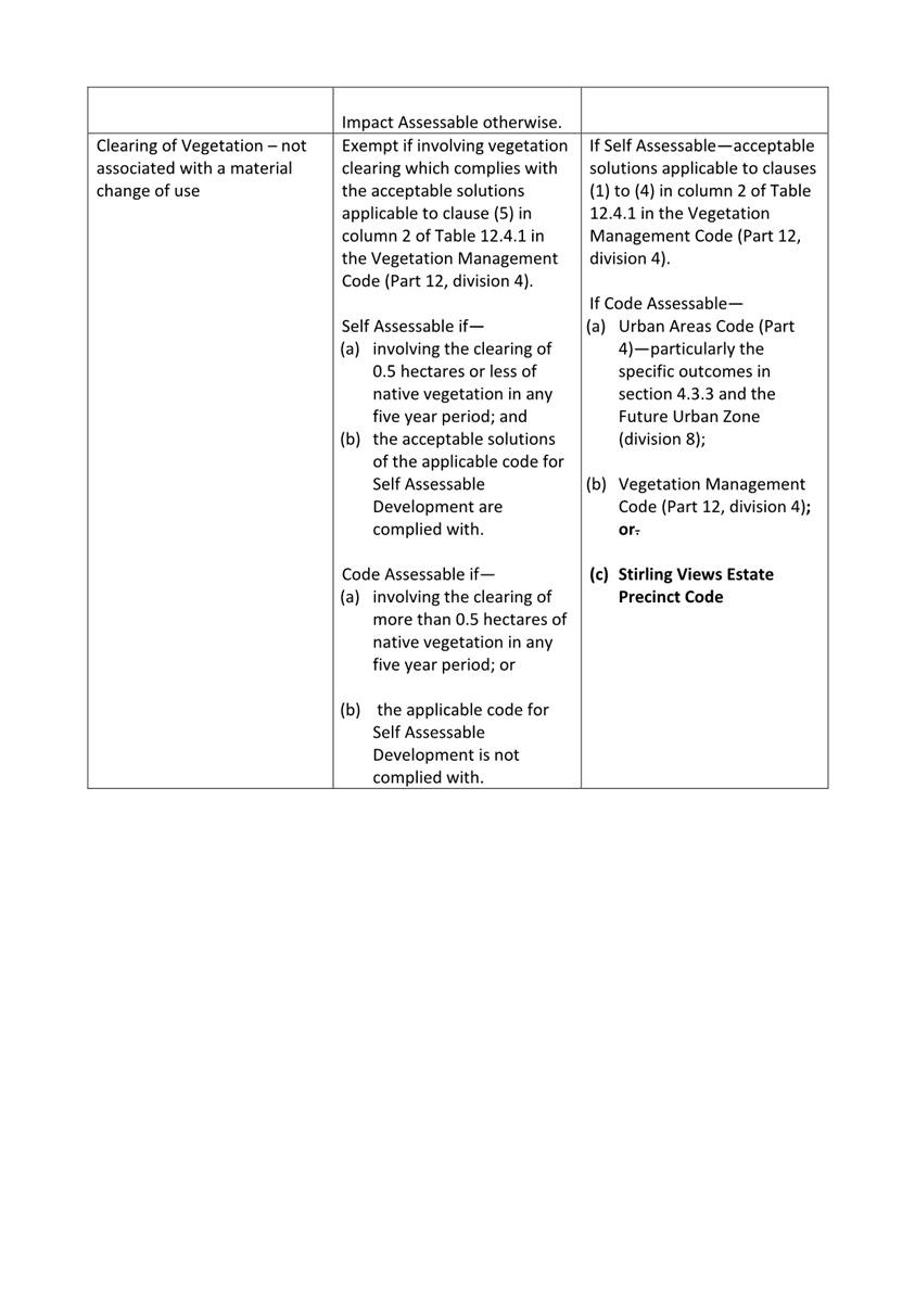
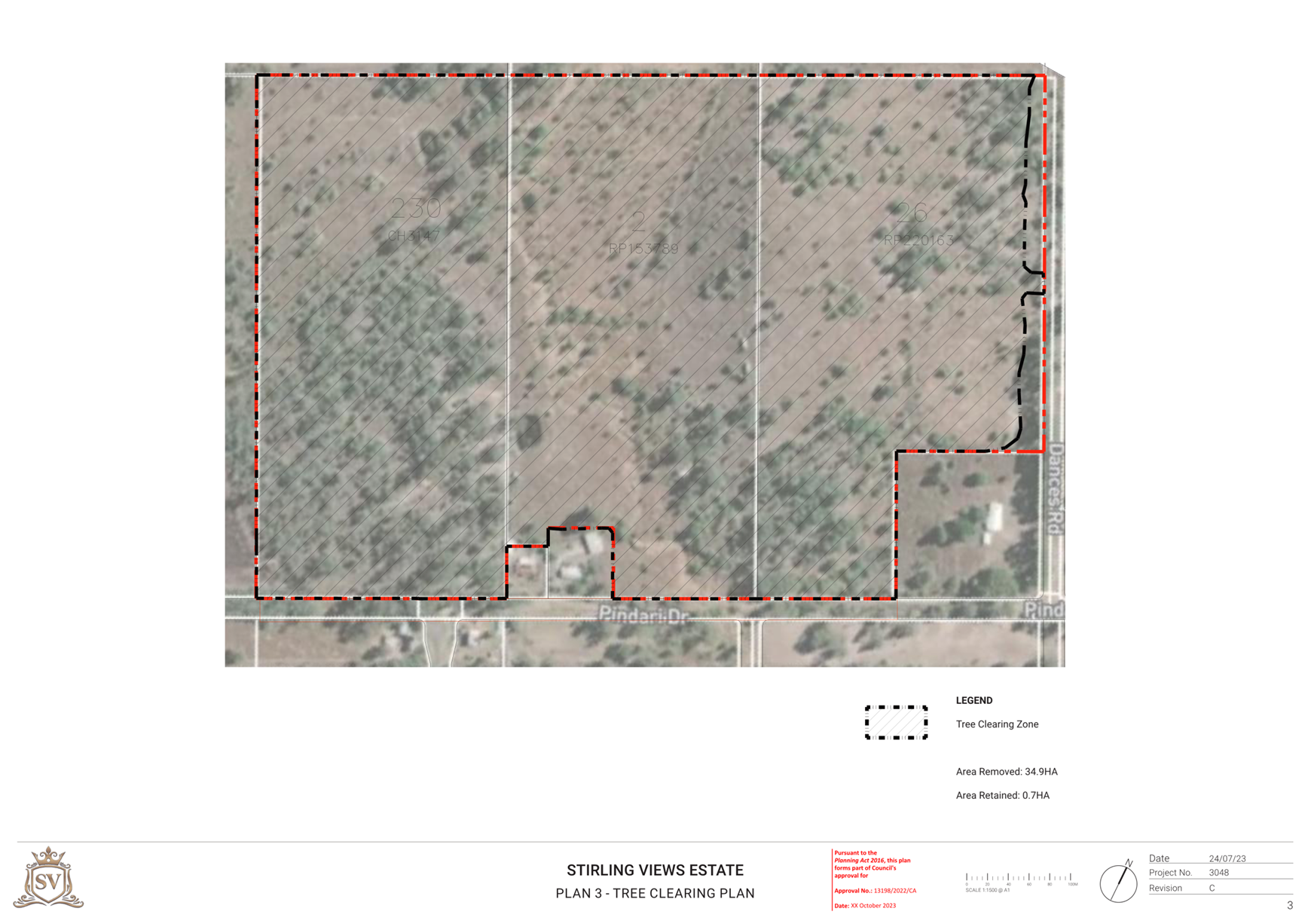
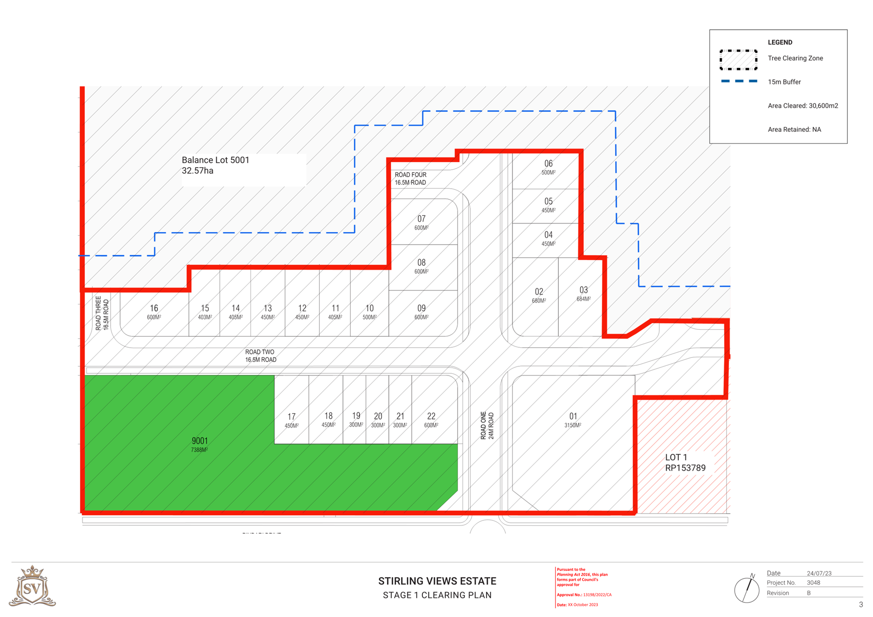
Ecology and Vegetation Clearing
The site contains areas of established regrowth vegetation that is classified by the State Government as Category X vegetation. This type of vegetation is exempt from State Government restrictions and requirements for clearing. In addition, the site is not mapped by the State Government as containing remnant vegetation or high value regrowth, as being located within a koala priority area or containing either core koala habitat or locally refined koala habitat areas. Accordingly, the removal of the existing vegetation as a result of the proposed development did not require referral to the State Government and the related State assessment benchmarks did not need to be addressed.
The applicant submitted an ecological assessment prepared by a suitably qualified person that characterises the site into two (2) broad vegetation communities being:
1. Exotic grasslands with scattered trees (Eucalyptus sp) – 26.9 hectares; and
2. Regrowth Low – Med High Eucalyptus Forest (Eucalyptus molucanna, E. terreticornis, E.crebra and E.tesselaris) – 8.8 hectares.
The regrowth community exists across three, distinct areas across the site and is characterised by predominantly cleared understorey with a high prevalence of weeds including lantana. As a result of on-site investigations, no threatened or endangered flora or fauna species (including koalas) protected under the Nature Conservation Act 1992 (Qld) or the Environment Protection and Biodiversity Conservation Act 1999 (Cth) were identified within the subject site. Accordingly, it is considered that the proposed development will not have detrimental impacts on protected animals or plants. The obligations of both the Queensland and Commonwealth legislation with respect to protected animals and plants remain despite any approval issued by Council, and so any person conducting clearing as a result of the proposed development will still need to ensure they satisfy these obligations.
While the proposed development will result in the loss of nearly all of the existing vegetation on-site (Figure 16 below), the proposed recreated waterway will be designed and constructed to facilitate the establishment of vegetation that will, over time, restore habitat and ecological functions for non-protected plant and animal species both within the proposed development and the surrounding area. The applicant is proposing, and a condition is recommended for inclusion (Condition 7 – Recreated Waterway / Drainage channel) to ensure, that the recreated waterway is fully constructed and vegetated as part of Stage 1 works to ensure the establishment and growth of vegetation starts early. The recreated waterway will then be held in ownership by the developer in a ‘maintenance stage’ for a substantial period of time as the development unfolds, and replanted as necessary prior to ultimate handover to Council to ensure the proposed objectives for this waterway are achieved as part of the development.
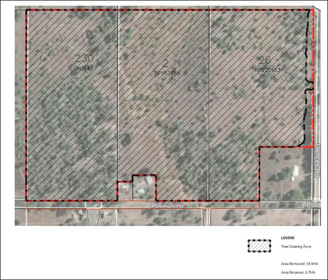
Figure 16 – Proposed extent of clearing
Park and Open Space Network
The Planning Scheme’s Local Government Infrastructure Plan and the Walloon/Thagoona LUCMP Greenspace Plan identifies one local recreation park (ID 76) and two (2) local linear parks (IDs 1030 and 1032) partially located within the subject site. The proposed development will provide the appropriate local linear park sections as part of Stages 5, 7, 9 and 15 and the local recreation park as part of Stage 9 (Figure 5 above). The proposed overall layout demonstrates sufficient area will be available to meet the standards outlined in both the LGIP and the LUCMP, and the specific requirements for the provision of these parks will be detailed in conditions for the subsequent Reconfiguring a Lot applications. The proposed development is considered to be consistent with the relevant assessment benchmarks for the provision of parks and open space.
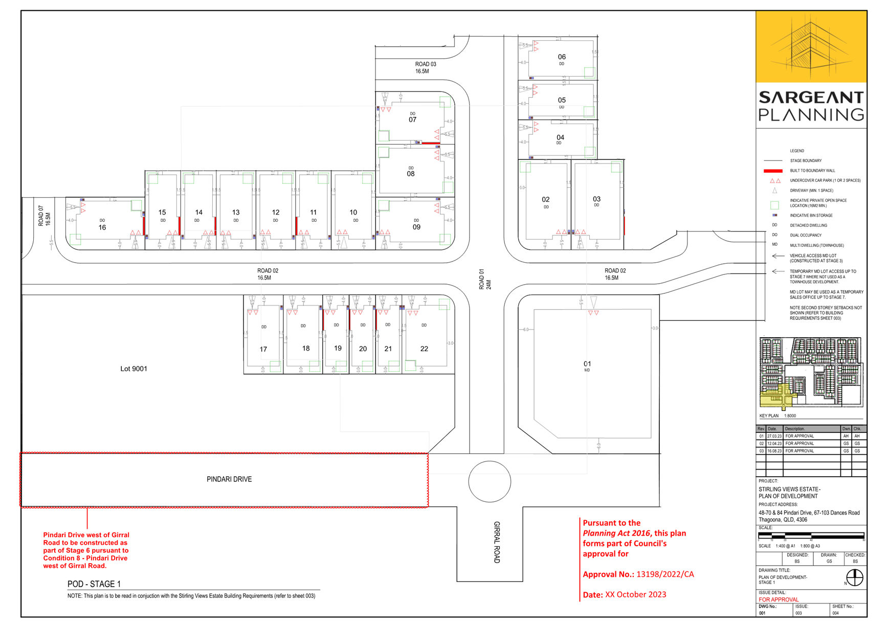
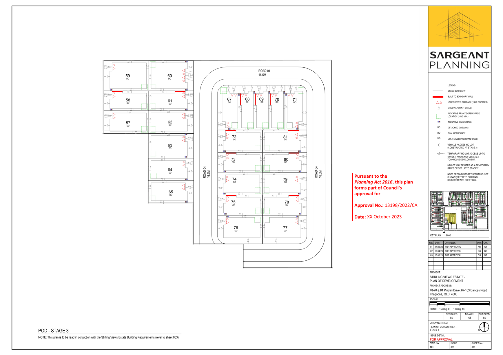
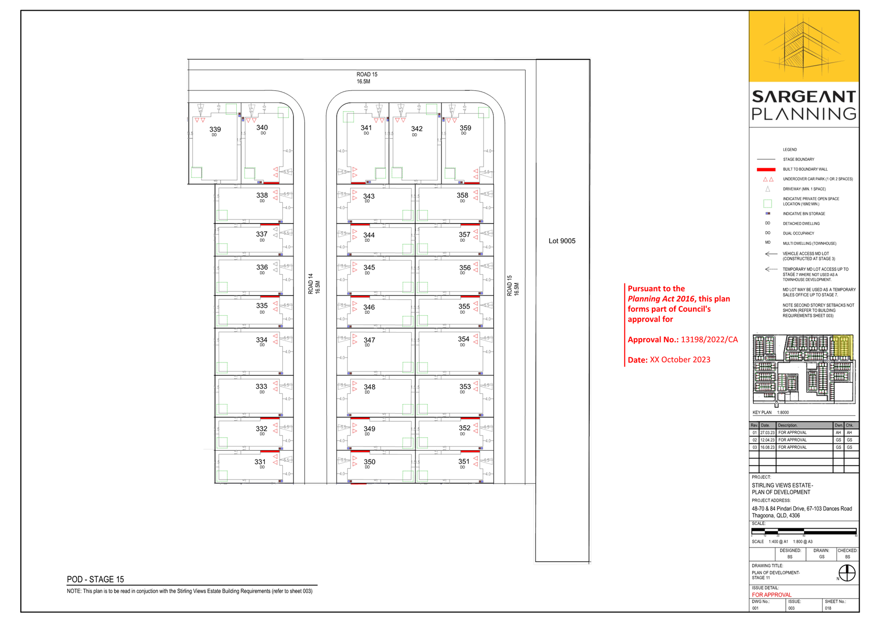
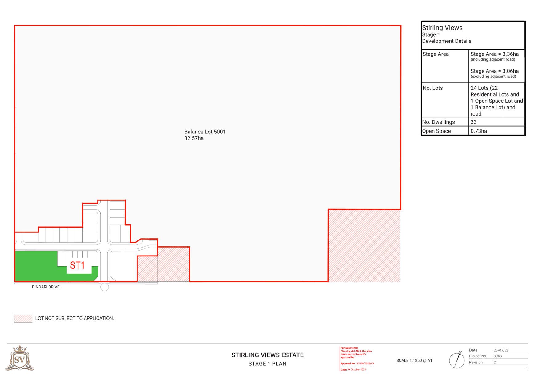
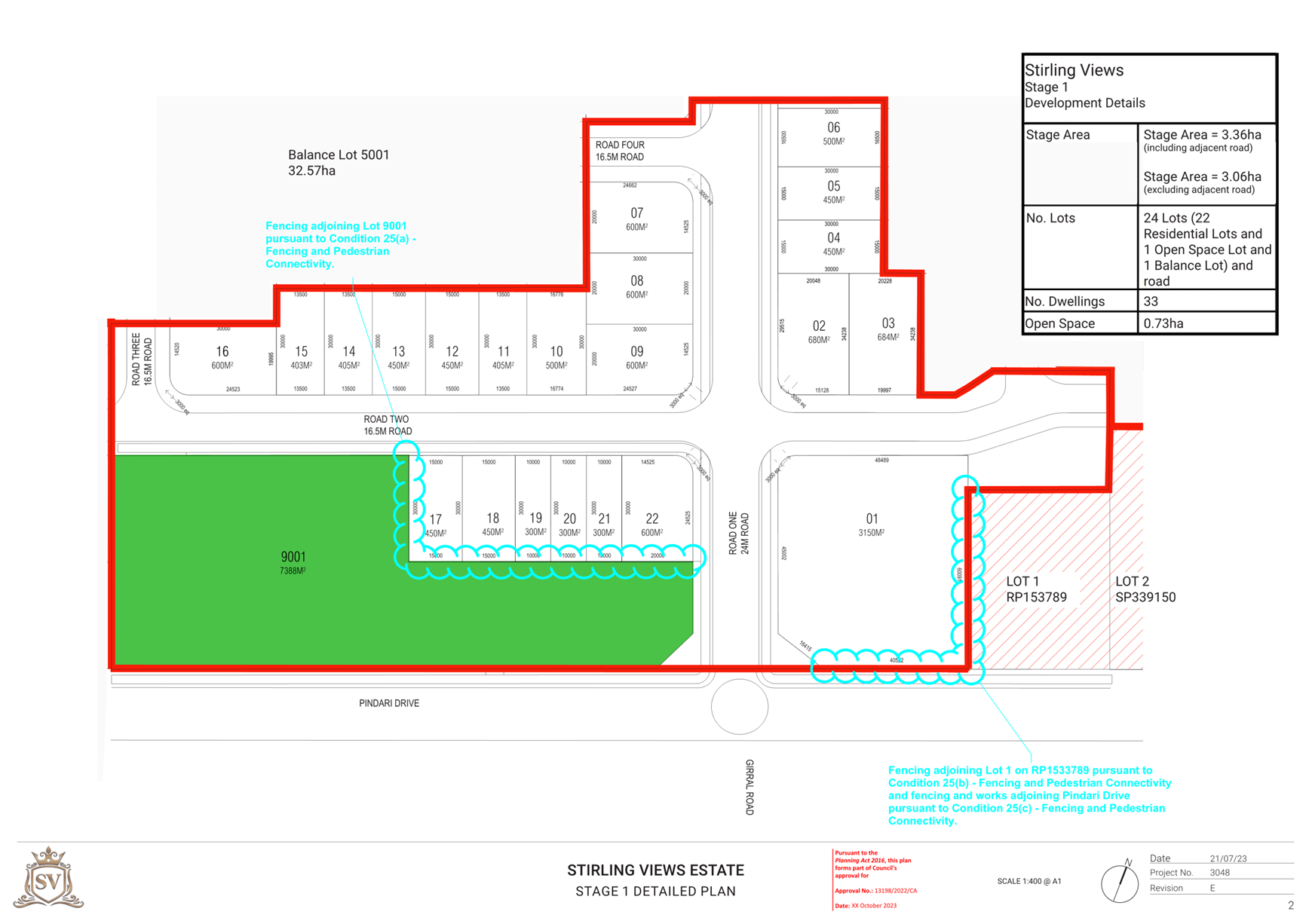
Development Permit for Stage 1 - Reconfiguring a Lot for 1 lot into 24 lots
The applicant is seeking a development permit for Stage 1 which will include 22 residential lots, one 7,388m2drainage lot and a single 32.57 hectare balance lot for the remainder of the proposed development that will be further subdivided as part of future Reconfiguring a Lot applications.
The first stage will include three (3) 300m2 lots, three (3) 405m2 lots, six (6) 450m2 lots, two (2) 500m2 lot, five (5) 600m2 lots, two (2) lots greater than 650m2 and one (1) multiple residential lot of 3,150m2(Figure 17 below). As discussed above, as part of this stage the applicant will be required to upgrade Girral Road to a residential collector standard to ensure impacts on local residents by way of increased traffic during construction are reduced.
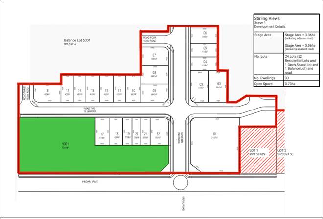
Figure 17 – Proposed Stage 1 layout
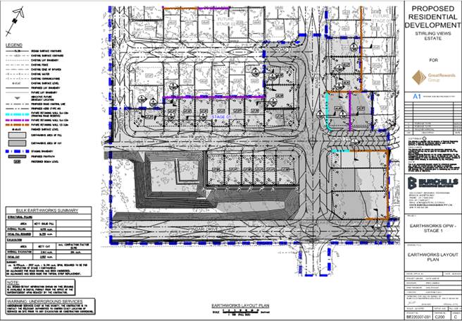
Development Permit for Stage 1 – Operational Works for 1 lot into 24 lots
The applicant is seeking a development permit for vegetation clearing and bulk earthworks associated with Stage 1 only (Figure 18). These works will facilitate the overall final landform for proposed Stage 1, and separate applications will be required for the associated civil works (roads and streetlights. As discussed above, in addition to upgrading Girral Road to a residential collector standard, the applicant will also be conditioned as part of the Preliminary Approval to construct and plant the recreated waterway and to upgrade Girral Road as part of Stage 1. These works will be subject to separate Operational Works applications.
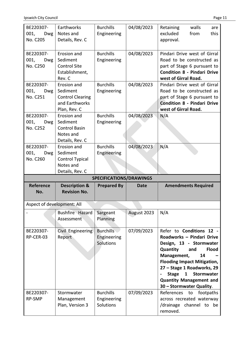
ASSESSMENT BENCHMARKS:
The application is Impact Assessable and has been assessed against the assessment benchmarks set out by the categorising instruments in accordance with section 45(5)(a)(i) of the Planning Act 2016.
The relevant assessment benchmarks which have been applied for the purposes of this assessment are as follows:
|
Categorising Instrument |
Assessment Benchmarks |
|
State Planning Policy July 2017, Part E |
Planning for liveable communities and housing Planning for economic growth Planning for environment and heritage Planning for safety and resilience to hazards Planning for infrastructure |
|
South East Queensland Regional Plan 2017 |
Chapter 3, Part A: Goals, elements and strategies · Goal 1: Grow o Element 1: Efficient land use § Strategy 1: Accommodate the region’s urban growth needs in the Urban Footprint in an efficient manner (Map 2) § Strategy 2: Plan for and accommodate the consolidation dwelling supply benchmarks (Figure 7), and an adequate supply in the interim (Figure 10) through new development in the existing urban area (including redevelopment), with a focus on corridors and centres. § Strategy 3: Prioritise the investigation, planning and delivery of urban development in suitable locations within the Urban Footprint that are underutilised. o Element 4: Housing diversity § Strategy 1: Provide housing choice by delivering a mix of dwelling types and sizes in consolidation and expansion locations consistent with the strategies in elements 1–3. § Strategy 2: Plan for and deliver a greater range of ‘missing middle’ housing forms (including examples shown in Figure 9) in suitable locations. § Strategy 3: Plan for and support innovative solutions in housing to cater for a diverse range of community needs, including an ageing population, multi-generational families, group housing, people with special needs and those from different cultural backgrounds. § Strategy 4: Maximise the variety of available land in suitable locations to support a range of housing choices under a range of market and economic circumstances. · Goal 3: Connect o Element 1: An efficient movement system § Strategy 1: Maximise the safe and efficient use of existing transport infrastructure to support the desired regional settlement pattern and major economic areas. o Element 2: Active transport § Strategy 4: Design new urban communities to ensure active and public transport are the most convenient and easiest way to move around, to reduce private vehicle dependence. o Element 5: Regional infrastructure networks § Strategy 1: Ensure land use and built form support the efficient use of existing regional infrastructure networks, and cost-effective augmentation of infrastructure for energy, water and sewerage to meet needs. · Goal 4: Sustain o Element 7: Health and wellbeing § Strategy 1: Design communities to be walkable, attractive and comfortable, and have high-amenity environments consistent with the elements and strategies of the ‘Live’ theme. § Strategy 2: Ensure that all communities have adequate and appropriate social infrastructure. § Strategy 4: Ensure the community has adequate access to sport and recreation opportunities that use the region’s natural assets sustainably and do not compromise the region’s biodiversity values. o Element 8: Fairness § Strategy 1: Ensure communities have suitable access to frequent and reliable public transport, as well as walking and biking options, to allow access to employment, education and services locally and more broadly. o Element 10: Safety § Strategy 1: Design communities that acknowledge and appreciate diversity and provide interactive public and open spaces to cultivate a sense of place and community belonging consistent with the elements and strategies of the ‘Live’ goal. § Strategy 2: Integrate community safety considerations into development design and delivery, including Crime Prevention Through Environmental Design principles. § Strategy 3: Maintain and improve natural assets that can mitigate risks associated with natural processes, and hazards such as flooding, salinity, landslide and bushfire. § Strategy 4: Use disaster risk management planning and adaptation strategies (such as the Queensland Strategy for Disaster Resilience), and avoidance of exposure to high-risk areas to minimise SEQ’s vulnerability to development constraints and natural hazards. o Element 11: Affordable living § Strategy 1: Plan for a greater number and broader range of dwellings closer to jobs and services to support affordable living options. § Strategy 2: Use the planning system to increase housing choice and diversity, and remove unnecessary regulatory costs. § Strategy 4: Promote an adequate and diverse supply of affordable housing in well-serviced locations. Chapter 3, Part C: Sub-regional directions · Western sub-regional outcomes o 2 – The intent to deliver more and complete communities that are well-planned and serviced will be achieved in areas including: … g. Rosewood/Thagoona/Walloon … |
|
Ipswich Planning Scheme 2006 |
Desired Environmental Outcomes and Performance Indicators (Part 3) Urban Areas Code (Part 4 and in particular division 3, division 4 – Large Lot Residential Zone and division 8 – Future Urban Zone) Vegetation Management Code (Part 12, division 4) Reconfiguring a Lot Code (Part 12, division 5) Residential Code (Part 12, division 6) Earthworks Code (Part 12, division 15) Local Government Infrastructure Plan (Part 13) |
The following are the reasons why the application was approved despite the development not complying with the following assessment benchmarks:
|
Categorising Instrument, Assessment benchmark |
Reasons for approval despite non-compliance |
|
Ipswich Planning Scheme 2006 – Part 4, division 4 – Large Lot Residential Zone Overall Outcome 4.4.2(2)(a) – The Large Lot Residential Zone caters primarily for residential uses on large suburban (i.e. acreage) lots, to the general exclusion of most other uses.
Specific Outcome 4.4.3(1) – Uses and works reflect the established built character, maintain amenity and protect and enhance important townscape and landscape elements within local areas having regard to- … (b) dwelling density; (c) lot sizes and dimensions; (d) boundary clearances and the provision of space around buildings; … |
A comparatively small part of the site in the north eastern corner is located within the Large Lot Residential Zone rather than the Future Urban Zone in Part 4 – Urban Areas of the planning scheme. The outcomes sought for the Large Lot Residential Zone generally envisage large suburban (i.e. acreage) lots. The proposed development is an integrated urban residential community across the entirety of the site and the land within the Large Lot Residential Zone is not proposed for large suburban (acreage) style lots. Notwithstanding, it is considered that the proposed development complies with the remainder of the Large Lot Residential Zone Code overall and specific outcomes as the subsequent uses will be provided with the full range of urban services and will maximise the efficient extension and safe operation of infrastructure. The proposed development is also considered to comply with all relevant overall and specific outcome of the Urban Areas Code and relevant assessment benchmarks within South East Queensland Regional Plan 2017 (ShapingSEQ) and so can be approved despite the non-compliance with Overall Outcome 4.4.2(2)(a) and Specific Outcomes 4.4.3(1)(b)-(d) of the Large Lot Residential Code. |
OTHER MATTERS GIVEN REGARD:
The assessment must give regard to the relevant matters identified in section 31 of the Planning Regulation 2017 and in accordance with section 45(5)(a)(ii) of the Planning Act 2016.
The application was given regard to, the following matters:
|
Relevant matter |
Given regard to |
|
Planning Regulation 2017, s31(1)(d) |
(i) the regional plan for a region, to the extent the regional plan is not identified in the planning scheme as being appropriately integrated in the planning scheme; and (ii) the State Planning Policy, to the extent the State Planning Policy is not identified in the planning scheme as being appropriately integrated in the planning scheme. |
|
Planning Regulation 2017, s31(1)(f) |
any development approval for, and any lawful use of, the premises or adjacent premises; and |
|
Planning Regulation 2017, s31(1)(g) |
the common material. |
OTHER RELEVANT MATTERS:
In accordance with section 45(5)(b) of the Planning Act 2016 the assessment may be carried out against, or having regard to, any other relevant matter other than a person’s personal circumstances, financial or otherwise.
In this instance the assessment had regard to the following:
· Relevant sections of the public consultation version of the draft Ipswich Plan 2024 including the Strategic Framework, Local Area Framework – Area 24 Walloon and Thagoona, Category of Development and Level of Assessment for Uses in the Residential, Township and Emerging Community Zones, the Dwelling House and Dual Occupancy Code, the Multiple Dwelling and Accommodation Code and the Reconfiguring a Lot Code.
· Draft ShapingSEQ 2023 Update
VARIATION REQUEST:
The Planning Act requires that in assessing a variation request, the assessment manager must consider the consistency of the variations sought with the rest of the local planning instrument that is sought to be varied. The assessment manager must consider the effect the variations would have on submission rights for later development applications, particularly considering the amount and detail of information included in, attached to, or given with the application and available to submitters.
For ease of reading, the variations to the Ipswich Planning Scheme 2006 sought by the applicant are summarised in Attachment 1. The applicant as part of the preliminary approval component is seeking the following variations to the Ipswich Planning Scheme 2006:
Summary of variations sought and consideration in accordance with section 61 of the Planning Act 2016
In terms of the variations sought to levels of assessment for residential uses, the applicant is seeking to have display housing and dual occupancy uses changed from code assessable development requiring a planning approval to self assessable development that will not require a planning approval provided it complies with the nominated assessment benchmarks. This is not considered appropriate, as were the proposed development located on a site included in the Residential Low Density Zone under the Planning Scheme both of these uses would be code assessable – in the case of display housing as long as there was only one house and in the case of a dual occupancy as long as the lot had an area of at least 800m2. On this basis, it is recommended that the level of assessment for display housing to remain unchanged and for dual occupancies to be code assessable development where located on a lot nominated as part of the approved documents and to be impact assessable otherwise. This will ensure that only sites that are known to the public as being nominated for dual occupancy will avoid public notification requirements. It will also permit the levying of infrastructure charges for the additional demand, as the current Ipswich Adopted Infrastructure Charges Resolution (No.1) 2023 does not provide a mechanism for the levying of charges on building work applications.
The applicant is also proposing to reduce the level of assessment for subsequent multiple residential uses to code assessable where located on a lot nominated as part of approved documents and to be impact assessable otherwise. Currently, multiple residential uses are impact assessable on the site and would be where the proposed development to be included in the Residential Low Density Zone. It is noted, however, that the level of assessment for multiple residential uses proposed in the public consultation version of the draft Ipswich Plan 2024 is proposed to be code assessable in all residential zones. On this basis, and consistent with the level of assessment for dual occupancies, it is considered that a reduction in the level of assessment from impact assessable to code assessable where located on a nominated lot is acceptable as the future use of the sites will be clear as part of the approved documents.
In terms of single residential uses, the applicant is not proposing a change to the level of assessment but rather is seeking to add words to the qualification triggering a requirement for a code assessable application that will mean only houses on lots 300m2 or greater have the potential to be self-assessable. Since the applicant is not proposing to create lots smaller than 300m2, it is considered the proposed addition is minor in nature and can be supported.
Similarly, the applicant is proposing to change the level of assessment trigger for subsequent Reconfiguring a Lot applications so that they would be code assessable where located within proposed unique zones (Stirling Views Residential Zone and Stirling Views Open Space Zone) and create either lots 300m2 or greater or open space or roads. These unique zones were included as part of a proposed Preliminary Approval Document that also included a unique Stirling Views Estate Precinct Code which was intended to override multiple existing Planning Scheme Codes. This approach is not supported, as the proposed code retained the bulk of existing code content and where it is different it is in ways that are considered to be incompatible with the rest of the existing Planning Scheme and also planning scheme drafting principles consistent with delivering on the purpose of the Planning Act 2016. As such, the addition of unique zones as a trigger for a level of assessment change is not supported but it is considered appropriate that the existing references to Future Urban Zone sub areas be removed and that applications be code assessable where they will not create lots less than 300m2 and impact assessable otherwise.
As an alternative to the creation of a unique code and zones as part of a Preliminary Approval Document, it is considered that the applicant’s proposed Plan of Development (POD) can instead be incorporated into the relevant assessment benchmarks. The proposed POD will establish building setbacks, envelopes and design requirements including the requirement for landscaping that are mostly identical to existing Planning Scheme and Queensland Development Code (QDC) requirements on the proposed lot types within the development. The main departures in terms of subsequent residential uses are that road setbacks for all lots will be 4m (currently 6m for lots greater than 450m2), site coverage of up to 60% will be permitted for lots between 300m2 and 399m2 (currently 50% for all lots) and each dwelling will need to provide rainwater tanks.
The main departures in terms of proposed lots are that the lot mix and proportions are not consistent with current probable solutions outlined in Appendix A of the Reconfiguring a Lot Code (lots less than 400m constitute more than 10% of the proposed development). In terms of the site cover and road frontage setbacks, it is noted that these are common siting variations requested by and granted to private certifiers and are typical for contemporary developments throughout South East Queensland and other residential growth areas within Ipswich. Similarly, the proposed lot mix and proportions are also consistent with contemporary developments within other residential growth areas within Ipswich and are notably required in order to achieve the ShapingSEQ dwelling targets and assessment benchmarks. Accordingly, it is considered the addition of the proposed POD as a relevant assessment benchmark can be supported. This also means that no variations will be required to Tables 12.6.1 and 12.6.2 of the Residential Code.
It is noted that the applicant did not seek to alter the level of assessment for subsequent Operational Work for clearing vegetation but to add the unique Stirling Views Residential Estate Precinct Code which is not supported. As such no changes to this type of development are considered necessary. The applicant is also proposing a currency period and completion dated of 10 years and given the scale of the proposed development this is considered to be an appropriate timeframe.
For ease of reading, the variations to the Ipswich Planning Scheme 2006 that are recommended to supported as part of this application are summarised in Attachment 2.
VARIATION APPROVAL:
Not applicable.
OTHER RELEVANT INFORMATION:
Not applicable.
NOTICE ABOUT THE DECISION (STATEMENT OF REASONS):
In accordance with section 63 of the Planning Act 2016, a ‘notice about the decision’ is required for this application. Accordingly, a Statement of Reasons is included with this decision. This Statement of Reasons provides the justification for Council’s decision.
INFRASTRUCTURE CHARGES AND INFRASTRUCTURE AGREEMENTS:
Pursuant to section 119 of the Planning Act 2016, an infrastructure charges notice has been given for roadworks, open space and land for community facilities totalling $285,320.00. These charges relate only to Stage 1, and subsequent Reconfiguring a Lot applications for the remaining stages will include the charges for the balance of the proposed development.
These infrastructure charges are calculated based on the lesser of the charge rates stipulated in Schedule 2 (trunk infrastructure network charges) of Council’s Adopted Infrastructure Charges Resolution or the maximum adopted charge calculated under the Planning Act 2016 and the Planning Regulation 2017. In this particular instance, infrastructure charges have been calculated based on Schedule 2 (trunk infrastructure network charges.
SIGNIFICANT COMMUNITY DEVELOPMENT OUTCOMES:
· The proposed development will deliver a mix of housing types and lot sizes that will help Council achieve the expansion dwelling targets set under ShapingSEQ and, through providing additional choice and availability, should improve housing supply over the next 10 years;
· The proposed development will result in improvements to the extent of stormwater inundation experienced by downstream properties;
· The proposed development will deliver improvements to both the local and State-controlled road networks improving safety and connectivity for locals and the broader community;
· The proposal will include a minimum 5000m2 Local Recreation Park and Linear Parkland along a rehabilitated waterway corridor, thereby improving access to recreational facilities and providing habitat for native fauna and flora.
Legal IMPLICATIONS
This report and its recommendations are consistent with the following legislative provisions:
· Planning Act 2016
· Planning Regulation 2017
· South East Queensland Regional Plan 2017
· State Planning Policy 2017
· Ipswich Planning Scheme 2006
· Ipswich Adopted Infrastructure Charges Resolution (No. 1) 2023
policy implications
RISK MANAGEMENT IMPLICATIONS
A risk to Council exists should the proposal not be determined in accordance with legislative requirements. The assessment and subsequent recommendations have been prepared to minimise the risk.
Financial/RESOURCE IMPLICATIONS
There are no resource implications associated with this report.
CONSULTATION
REFERRAL AGENCY
State Assessment and Referral Agency
The Department of State Development, Infrastructure, Local Government and Planning, in their capacity as the State Assessment and Referral Agency (SARA), provided their referral response (concurrence agency) on 1 June 2023. The application was referred to SARA for the following identified in the Planning Regulation 2017:
- Schedule 10, Part 9, division 4, subdivision 1, table 1, item 1 – Development impacting on state transport infrastructure in schedule 20 of the Planning Regulation 2017.
As part of their response, SARA have imposed conditions requiring:
- Upgrades to the Karrabin Rosewood Road / Girral Road intersection designed and constructed in accordance with the Department of Transport and Main Roads’ Road Planning and Design Manual and Austroads Standards based on a 110km/h design speed prior to submitting the Plan of Subdivision for Stage 1 to Council;
- Upgrades to the Karrabin Rosewood Road / Tarana Avenue intersection designed and constructed in accordance with the Department of Transport and Main Roads’ Road Planning and Design Manual and Austroads Standards based on a 110km/h design speed prior to submitting the Plan of Subdivision for Stage 14 (or any other stage that facilitates the construction of vehicular access to Dances Road) to Council;
- Development to be carried out in accordance with an approved Stormwater Management Plan with RPEQ certification and supporting documentation to be provided to DTMR confirming compliance prior to submitting the Plan of Subdivision to Council.
INTERNAL CONSULTATION
The application and common material was presented to Council’s Initial Development Assessment Panel (consisting of various representatives from across the organisation) for review upon lodgement. At this meeting, it was determined that internal referral was required to the Engineering, Health and Environment Branch, City Design Branch, Asset and Infrastructure Services Department and Environment and Sustainability Department.
The following assessment reports/comments were prepared and have been incorporated into the recommendation:
- Engineering and Environment report dated 22 September 2023 with recommended conditions relating to stormwater, roadworks, flooding impact mitigation, the recreated waterway, services and infrastructure;
- Parks advice dated 13 and 15 September 2023 with recommended conditions and comments relating to proposed plans and supporting information.
EXTERNAL CONSULTATION
Not applicable.
PUBLIC NOTIFICATION
Public notification of this application was undertaken pursuant to the Planning Act 2016. The applicant undertook public notification from 27 April 2023 to 12 June 2023 for a period of 30 business days. Council received 36 properly made submissions. A summary of the matters raised in the submissions include:
|
Matter raised |
How matters were dealt with in reaching a decision |
|
Support the proposed development as housing must be available for coming generations in order for the City to grow and thrive. |
The support for the proposed development noted and it is agreed that it will increase housing supply and diversity consistent with the relevant sections of the Ipswich Planning Scheme 2006 and ShapingSEQ. |
|
The proposed development will impact on many registered Habitat Gardens along Girral Road that have been established over 40 years and the native fauna and ecosystems that live within the area. |
The proposed development does not involve land within lots that contain registered habitat gardens. An ecological report has been submitted and assessed as part of the development application which finds that the development complies with all relevant environmental legislation and the development will facilitate community open space consisting of a fully vegetated recreated waterway and a new local recreational park which will provide habitat for native flora and fauna to connect to and complement those surrounding properties that choose to also continue to provide habitat. |
|
Properties downstream of the proposed development are currently subject to naturally occurring inundation up to knee-height that is filtered through the land. The proposed development will increase the amount of impervious area and stormwater flows adversely impacting downstream properties. If the proposed on-line detention fails this will cause increased inundation of properties including houses. |
The proposed development will increase the amount of impervious area by way of the delivery of roads, houses etc. However, the development application is supported by a Stormwater Management Report that demonstrates flooding and stormwater impacts on downstream properties will be lessened and improved as a result of mitigation works carried out to facilitate the proposed development. The mitigation works consist of a recreated waterway with online detention as well as an offline detention basin located in the southwest of the site adjacent to Pindari Drive. Conditions 7 – Recreated Waterway / Drainage channel, 13 – Stormwater Quantity and Flood Management, Condition 14 – Flooding Impact Mitigation, Condition 29 – Stage 1 Stormwater Quantity Management and Condition 31 – Stage 1 Flooding Impact Mitigation are recommended for inclusion to ensure no worsening of stormwater and flooding impacts are experienced by downstream properties. |
|
Girral Road at present is not wide enough for two vehicles to pass each other without moving onto the grass shoulders, has only been resurfaced twice in 40 years and is consistently in disrepair. The developer is not required to upgrade the road as they are inside the dwelling quota and so this will be a safety hazard with trucks and constant traffic during the construction stage and once houses are built. |
The applicant is proposing to upgrade Girral Road to a residential collector standard as part of Stage 1, and Condition 27 – Stage 1 Roadworks is recommended for inclusion to ensure it is provided prior to the creation of any residential lots associated with the development. |
|
The intersection of Girral Road with Karrabin Rosewood Road is in a 100km/h speed zone with existing turning movements difficult and dangerous – particularly as there are no turning lanes and when traffic slows for the local wildlife. |
The State Assessment and Referral Agency (SARA) has imposed a condition requiring the upgrade of this intersection to contemporary Department of Transport and Main Roads requirements as part of Stage 1. |
|
The construction of sewerage infrastructure will destroy the natural environment created by residents over the years. |
The Service Advice Notice issued by Urban Utilities confirms only that there will be the capacity to provide reticulated water and sewerage connections to the proposed development should the development proceed. The final alignment and construction standard required will be determined by Urban Utilities as part of a subsequent and separate water approval process under the South-East Queensland Water (Distribution and Retail Restructuring) Act 2009. |
|
Pindari Drive will be formed up to Dances Road as part of Stage 6 of the proposed development but not as far as Tarana Avenue, leaving a gravel section of around 55m that will be used instead of Girral Road to access Karrabin Rosewood Road. This will create a safety hazard and dust nuisance issue. It is reasonable for Pindari Drive to be constructed through to the intersection with Tarana Avenue as part of Stage 6. |
The proposal to leave a gravel section within Pindari Drive is not supported, and a condition is recommended for inclusion (Condition 9 – Pindari Drive east of Girral Road) requiring the construction of Pindari Drive through to the Tarana Avenue intersection. |
|
It appears the staging may have been designed so the developer never completes Stages 14 and 15 leaving a huge section of external road last. Stage 14 includes over 500m of road and four T intersections for only 13 lots, meaning that it will not make financial sense to complete Stage 14. It seems unusual for approximately half of the external road works to be completed with the last two stages representing less than 12% of the housing lots. It is reasonable for the staging to be altered so that Stage 14 become Stage 10, with the current Stages 10-13 becoming Stages 11-14, ensuring an orderly flow of development stages and upgrade to external roads. |
It is not until Stage 14 that the development intersects with Dances Road and until this time, traffic associated with the development would not be reasonably expected to use this section of road. As such, it would not be reasonable to require the upgrade to occur earlier, unless conditions were imposed bringing forward the connection to Dances Road. As the development will have two available road connections following Stage 6, it would not be reasonable to insist on an earlier delivery of the access to Dances Road and as such, it is not considered reasonable to alter the staging as suggested. Additionally, Dances Road is proposed to be upgraded to a rural collector standard rather than a residential collector. If the applicant does not construct Stages 14 and 15, there will be no road connections through to Dances Road and so upgrades and construction of this road will not be required. |
|
There are already dust impacts caused by existing residents and business driving on the unsealed Pindari Drive and Dances Road and the proposed development will increase these issues as road upgrades are not scheduled until after various stages of the development have been completed. Council should require that all roads in and out of the proposed estate are fully bitumen sealed before commencement of any other works on the proposed estate. |
The applicant is proposing to construct Pindari Drive as part of Stages 1, 6 and 14, and Dances Road as part of Stage 14.
The construction of Dances Road as part of Stage 14 to a rural collector standard as part of Stage 14 is considered to be reasonable as this is the only time traffic associated with the development would be accessing this road. In terms of Pindari Drive, however, conditions of development are recommended for inclusion (Conditions 27 – Stage 1 Roadworks and 9 – Pindari Drive east of Girral Road) that will instead require the construction of Pindari Drive as part of Stage 1 for initial access, and all the way through to the existing bitumen portion near Tarana Avenue as part of Stage 6. |
|
The proposed development, particularly upgrades required to Girral Road and to facilitate the construction of sewerage infrastructure through the ICC dedicated water quality and bushland reserve (Banyula Reserve), will adversely impact on koalas and numerous other native animals. To help prevent this, either Girral Road should be closed to traffic at the intersection with the Karrabin Rosewood Road or for Girral Road and Pindari Drive to be constructed with wildlife crossings, appropriate wildlife signage a speed limit of between 30km-40km/h and traffic calming measures. |
A condition is recommended for inclusion (Condition 4 – Ecological assessment for related works) requiring submission of reports prepared by a suitably qualified ecologist to provide recommendations and measures to mitigate impacts on native animals for any road or utility works associated with the development, including the upgrades of Girral Road, Pindari Drive and the connection of the development to stormwater, sewer, water and power networks, in conjunction with future Operational Works applications. |
|
Pindari Drive and Dances Road should be constructed with the first stage and not left until later in the development. |
The Planning Act provides limitations on Council as assessment manager applying conditions of approval to a development. In particular, a development condition must be relevant to, but not be an unreasonable imposition on, the development or the use of the premises as a consequence of the development; or be reasonably required in relation to the development or the use of the premises as a consequence of the development. It is considered that conditions relating to Pindari Drive and Dances Road would only be reasonable and relevant when they are required to provide access for lots as part of the proposed development, or when they are otherwise required to satisfy a relevant assessment benchmark. In this instance, conditions have been recommended for inclusion (Conditions 27 – Stage 1 Roadworks, 8 – Pindari Drive west of Girral Road and 9 – Pindari Drive east of Girral Road) that will require Pindari Drive to be constructed partially as part of Stage 1 and for the complete site frontage and past the intersection with Dances Road up to the existing bitumen near the intersection with Tarana Avenue as part of Stage 6, and for Dances Road to be upgraded as part of Stage 14. |
|
The rainfall information used to assess flooding and stormwater impacts dates is from the Dayboro post office and dates from 01/01/1990 to 31/12/1999. This excludes significant rainfall events in 1974, 2008 and 2011, 2013 and 2022. |
The Stormwater Management Plan submitted by the applicant adopts the latest methodologies outlined in the Australian Rainfall and Runoff 2019 (ARR19) and the Ipswich Planning Scheme 2006. These methodologies represent best practice in flood modelling assessments, and incorporate a number of data sets built from various rain gauges, and years of data.
ARR19, and flood modelling in general, adopts design rainfall events. Design rainfall are simulations that vary in intensity, storm pattern, and event durations as well as severity (i.e. extremely rare, rare, regular etc.). These design storms are generated by ARR Data hub, and built from years of data to represent the widest spectrum possible of potential flooding, which typically translates to Annual Exceedance Probability i.e. 1% AEP, 2%AEP etc.
The flood study assessed a range of events to determine the critical design storms for the area. Whilst historical flooding has not been simulated, the ARR Data and ARR flood modelling methodologies assesses all events in terms of severity (i.e. 1% AEP) using data built from a range of years and various locations which represents a more robust approach (i.e. not just one event).
With regards to the use of the Dayboro Post Office rainfall data, this was used only for the MUSIC modelling to assess pollutant runoff (this data was not used the flood or stormwater modelling). This is in accordance with the Water By Design MUSIC modelling guidelines which outline the rainfall stations which are to be used in which areas. This is current best practice for pollutant runoff modelling and is in accordance with the Ipswich Planning Scheme 2006 and the relevant state guidance material.
Altogether, it is considered that the submitted modelling is consistent with best practice in flood modelling practice and is in accordance with the relevant Ipswich City Council requirements and guidelines, as well as State and Federal guidance. |
|
The flooding and stormwater modelling appears to be at odds with Australian Government modelling which has predicted an increase of major rain events by forty percent, and play down the importance of the Main Western Rail Corridor by referring to it as the Thagoona railway line and not considering the impacts added flooding would have on it. |
In terms of the modelling adopted by the Stormwater Management Plan submitted by the applicant, it adopts the latest methodologies outlined in the Australian Rainfall and Runoff 2019 (ARR19) and the Ipswich Planning Scheme 2006. These methodologies represent best practice in flood modelling assessments, and incorporate a number of data sets built from various rain gauges, and years of data.
ARR19, and flood modelling in general, adopts design rainfall events. Design rainfall are simulations that vary in intensity, storm pattern, and event durations as well as severity (i.e. extremely rare, rare, regular etc.). These design storms are generated by ARR Data hub, and built from years of data to represent the widest spectrum possible of potential flooding, which typically translates to Annual Exceedance Probability i.e. 1% AEP, 2%AEP etc.
The flood study assessed a range of events to determine the critical design storms for the area. Whilst historical flooding has not been simulated, the ARR Data and ARR flood modelling methodologies assesses all events in terms of severity (i.e. 1% AEP) using data built from a range of years and various locations which represents a more robust approach (i.e. not just one event).
In terms of the impact on the Main Western Rail Corridor, the proposed development was referred to the State Assessment and Referral Agency (SARA) to determine any impacts of the proposed development on state transport infrastructure, which includes the Main Western Rail Corridor. SARA did not require any additional information, or raise any concerns regarding the proposed development, in terms of impacts on the Main Western Rail Corridor.
Altogether, it is considered that the submitted modelling is consistent with best practice in flood modelling practice and is in accordance with the relevant Ipswich City Council requirements and guidelines, as well as State and Federal guidance. |
|
The site contains a remnant koala colony and it appears no Environmental Impact Assessment has been undertaken to support the proposed development. Koalas are now listed as endangered under the Environment Protection and Biodiversity Conservation Act 1999 (Cth) (EPBC) and so the habitat should be left intact. |
The site is not mapped as included within a Koala Priority Area or containing either core or locally refined koala habitat. In addition, the applicant has submitted an Ecological Report that did not identify the presence of koalas within the site. Even so, as koalas are listed as endangered under the Environment Protection and Biodiversity Conservation Act 1999 (Cth) (EPBC) the applicant will be required to ensure the clearing required to facilitate the development is not a controlled action prior to carrying out the clearing. The Federal Department of Climate Change, Energy, the Environment and Water (DCCEEW) is responsible for enforcing the requirements of the EPBC. |
|
The proposed development includes small lots and multi-unit housing but provides no retail, medical or educational services. |
The Walloon/Thagoona Land Use Concept Master Plan (LUCMP) contained within the Ipswich Planning Scheme 2006 identifies a future major neighbourhood centre to be located near the intersection of Karrabin Rosewood Road and Thagoona Haigslea Road and a smaller neighbourhood centre closer to the Thagoona train station near the intersection of Thagoona Haigslea Road and Loder Road. These centres are identified consistent with the Planning Scheme’s Centres Hierarchy and Strategy as outlined in Schedule 7 and are intended, along with the Walloon Primary and Secondary Business Areas and three more Local Neighbourhood Centres, to provide retail and other community and government services commensurate with the expected residential population within the LUCMP area. Consistent with the Future Urban Zone Code, MNCs are intended to serve between 5,000 and 15,000 people and provide between 2,000m2 and 6,000m2 of floor space. A LNC, on the other hand, is intended to have up to 2,000m2 of floor space and to serve a localised catchment of up to 5,000 people.
While there are currently no retail, community or other services close to the proposed development, Council has received and is currently assessing a development application for the MNC located at the corner of Karrabin Rosewood Road and Thagoona Haigslea Road (127/2023/CA).
This centre, if approved, will be located around 1.5km travel distance from the proposed development via Girral Road and Karrabin Rosewood Road. Irrespective of the trajectory of the MNC application, as population increases it is expected that demand will see the need for the identified centres increase and so it is considered the full range of urban services necessary to support a new community can be available within a realistic timeframe.
It should also be noted that the LUCMP identifies a new primary school site located adjacent to the MNC. The final decision on the timing, location and size of schools rest with either the Queensland Department of Education or private school operators and Council has limited involvement and influence. However, in 2019 the Queensland Schools Planning Reference Committee (QSPRC) – Cross-Sectoral New Schools Demand Mapping 2021 to 2041 for Ipswich City Council identified that 1-2 new primary and 1-2 new secondary schools (government and non-government) would be required by 2031 in the Rosewood Statistical Area Level 2 (SA2) – an area which includes the proposed development.
Accordingly, it is considered the proposed development demonstrates that it will be planned and constructed in a way that appropriately integrates with necessary infrastructure and services and so is consistent with the relevant requirements of the Ipswich Planning Scheme 2006 and ShapingSEQ. |
|
The proposed development will result in pollutants and extra sediment in the stormwater that will affect downstream properties and the Banyula Reserve. |
The proposed development will include a stormwater quality treatment train including rainwater tanks and bioretention basins to ensure water quality for the recreated waterway and downstream properties and waterways is maintained.
Conditions 36 – Sediment and Erosion Management and 48 – Operational Works Sediment and Erosion Management are recommended for inclusion to ensure there will be no adverse impacts on the health of waterways in the area. |
|
Increased traffic on Girral Road will result in increased noise for existing residents – particularly the houses closest to the road. |
It is accepted that the proposed development will result in increased traffic along Girral Road and, by extension, increased noise associated with this traffic. However, as the proposed development is residential in nature the peak times for increased traffic movements will occur in the day time period where background noise will be elevated and issues such as sleep disturbance will not be pertinent. Given the location of the site in close proximity to RAAF Base Amberley, the Rosewood-Ipswich rail line and the Karrabin Rosewood Road it is not considered that the noise associated with increased vehicle movements will have significant adverse impacts and increase in background noise levels will be part of the transition of the locality from a rural residential setting to a more urban setting as is envisaged by the ShapingSEQ and Ipswich Planning Scheme 2006. |
|
There are a number of old large gum trees with hollows in Pindari Drive road reserve that provide important nesting hollows for birds and other wildlife. These should be retained where possible by redirecting roads and sewer pipes. |
It is accepted that the presence of senescent trees is important for wildlife, however in order to upgrade Pindari Drive to a standard consistent with the requirements of the Ipswich Planning Scheme 2006 it is unlikely that such trees within the road reserve will be able to be maintained. Nonetheless, a condition is recommended for inclusion (Condition 4 – Ecological assessment for related works) that will require submission of reports prepared by a suitably qualified ecologist to provide recommendations and measures to mitigate impacts on native animals for any road or utility works associated with the development, including the upgrades of Girral Road, Pindari Drive and the connection of the development to stormwater, sewer, water and power networks, in conjunction with future Operational Works applications. |
|
Green areas in the proposed development plan should be maintained including along the edges of the gully connecting to the Banyula Reserve to create a wildlife corridor of adequate width and retaining existing native vegetation. |
The proposed recreated waterway will be designed and constructed to ensure a revegetated outcome will ultimately be delivered. The applicant has proposed, and a condition is recommended for inclusion (Condition 7 – Recreated Waterway / Drainage channel) that will require the establishment of the recreated waterway as part of Stage 1 to give newly planted vegetation additional time to mature and establish as the rest of the development progresses. |
|
The proposed development will result in stormwater backing up through Banyula Reserve to Kavanagh Road East causing higher flood conditions than existing through to Adelong Avenue. |
The proposed development is supported by a Stormwater Management Plan that demonstrates flooding and stormwater impacts on downstream properties will be lessened and improved as a result of mitigation works carried out to facilitate the proposed development. Conditions 7 – Recreated Waterway / Drainage channel, 13 – Stormwater Quantity and Flood Management, Condition 14 – Flooding Impact Mitigation, Condition 29 – Stage 1 Stormwater Quantity Management and Condition 31 – Stage 1 Flooding Impact Mitigation are recommended for inclusion to ensure no worsening of stormwater and flooding impacts are experienced by downstream properties. |
|
Council is aware of the current drainage and stormwater issues in Thagoona and the existing infrastructure should be upgraded across Thagoona to remedy the existing issues before additional development that increases them is approved. |
The proposed development is supported by a Stormwater Management Plan that demonstrates flooding and stormwater impacts on downstream properties will be lessened and improved as a result of mitigation works carried out to facilitate the proposed development. Conditions 7 – Recreated Waterway / Drainage channel, 13 – Stormwater Quantity and Flood Management, Condition 14 – Flooding Impact Mitigation, Condition 29 – Stage 1 Stormwater Quantity Management and Condition 31 – Stage 1 Flooding Impact Mitigation are recommended for inclusion to ensure no worsening of stormwater and flooding impacts are experienced by downstream properties. |
|
The current culvert/spill intersection [sic] between Girral Road and Karrabin Rosewood Road is inadequate to permit 2 vehicles to pass each other and will not be able to support the weight of construction equipment and heavy vehicles. |
The State Assessment and Referral Agency (SARA) has imposed a condition requiring the upgrade of this intersection to contemporary Department of Transport and Main Roads requirements as part of Stage 1. In addition, the applicant is proposing and a condition is recommended for inclusion (Condition 27 – Stage 1 Roadworks), requiring the upgrade of Girral Road to a residential collector standard as part of Stage 1. |
|
All of the soil in Thagoona is kept damp from underground run-off from Mount Marrow. The soil is highly reactive to weather conditions and whether the soil is wet or dry and so any changes to downstream subsurface water flows will affect footings and result in property damage for existing houses by way of impacts to slabs. |
Moisture levels within soils are highly variable dependent on weather conditions generally, which the subject development approval does not influence in any material way. Building legislation which has been in place for many years and ought to have been properly considered in the construction of buildings in the surrounding area has required soil testing and slab/foundation designs be undertaken by professional engineers to ensure structures suitably cater for varied soil structures and weather conditions. It not possible to apply a condition to the development which would act to maintain soil moisture levels and indeed even if one were to be applied, it would be highly uncertain and would fail multiple requirements for permitted development conditions as set out in the Planning Act. The development will include a reduction in downstream stormwater impacts and this has been noted as a positive outcome for many properties which are currently impacted by drainage impacts. |
|
Girral Road currently acts as a waterway and so any upgrades and extension of Girral Road will increase the amount of water flows and potentially contribute to an increased likelihood of stormwater ingress into houses on the lower section of the road. |
The detailed design for the upgrade of Girral Road as required by Condition 27 – Stage 1 Roadworks will be determined as part of a subsequent Operational Works application. In addition, the applicant has submitted a Stormwater Management Plan that demonstrates the upgrades for the Council- controlled length of Girral Road will not have an adverse impact by way of stormwater inundation on adjoining properties. |
|
The developer should be required to undertake further analysis of local flooding and provide alternative solutions to the problems of increased water runoff that better accounts for the cumulative impacts of other applications currently lodged with Council that will drain through O’Sheas Gully down to the lower areas in Thagoona along Adelong Avenue. |
O’Sheas Gully is located in a separate catchment to the proposed development and the downstream properties, and the applicant has submitted a Stormwater Management Plan that demonstrates as a result of the proposed development and the recommended stormwater management measures there will be reduced impacts on downstream properties caused by stormwater inundation. Other development applications which do drain to O’Sheas Gully will also need to consider downstream impacts. |
|
There is no timing known for the upgrade to the Girral Road and Karrabin Rosewood Road intersection and the minor upgrade required by the State Assessment and Referral Agency is inadequate for a 100km/h road. |
The State Assessment and Referral Agency (SARA) has imposed a condition requiring the upgrade of this intersection to contemporary Department of Transport and Main Roads requirements as part of Stage 1. |
|
The developer is proposing to upgrade Girral Road to a rural collector standard only, which is insufficient for drivers, cyclists and pedestrians. |
The applicant is proposing to upgrade Girral Road to a residential collector standard as part of Stage 1, and Conditions 27 – Stage 1 Roadworks is recommended for inclusion to ensure it is provided. Consistent with the requirements of the Ipswich Planning Scheme 2006 a residential collector appropriately caters for vehicles, pedestrians and cyclists. |
|
The proposed detention basin will prolong the release of water through and will worsen existing drainage and stormwater issues for downstream properties by causing water to run for longer. This will cause health problems for downstream residents’ horses including hoof injuries, swelling, abscesses and greasy heel issues and will make arenas etc unusable. |
The proposed development is supported by a Stormwater Management Plan that demonstrates flooding and stormwater impacts on downstream properties will be lessened and improved as a result of mitigation works carried out to facilitate the proposed development. Conditions 7 – Recreated Waterway / Drainage channel, 13 – Stormwater Quantity and Flood Management, Condition 14 – Flooding Impact Mitigation, Condition 29 – Stage 1 Stormwater Quantity Management and Condition 31 – Stage 1 Flooding Impact Mitigation are recommended for inclusion to ensure no worsening of stormwater and flooding impacts are experienced by downstream properties. |
|
The proposed development will create massive dust pollution issues, particularly during construction, which will last for years and will particularly impact residents of Girral Road who have pre-existing lung conditions. |
All subsequent Operational Work and Building Work applications will be subject to an application and approval process which will result in regulatory requirements concerning dust generation and impacts during construction. If dust nuisance is experienced during construction activities for the development, these matters will be able to be raised with Council at the time, and a range of legislative standards can be enforced to ensure such nuisance is minimised to an acceptable standard. |
|
There does not appear to be a bushfire plan. This is a semi-rural area and bushfires are part of life, a fire in the bushland behind the development would be a massive safety issue with Girral Road as the only way in and out and hundreds of residents trying to evacuate. |
The applicant has submitted a Bushfire Hazard Assessment that determines the proposed development will not increase the risk of either existing or future residents of the area by way of bushfire hazard. It is likely that through the construction of the development and associated road upgrades, accessibility for firefighting for the surrounding area will be substantially improved. In addition, a condition is recommended for inclusion (Condition 6 – Bushfire Safety) that will require subsequent residential development is carried out consistent with the requirements of the submitted Bushfire Hazard Assessment. |
|
The developer’s ecological report is inadequate and shows limited understanding of the type and number of local animals, birds and insects. The proposed development will result in the destruction of habitat within the site, the Girral Road and Pindari Drive road reserves and in Banyula Reserve. |
The proposed development is supported by an Ecological Assessment Report that did not identify the presence of any threatened, vulnerable or endangered plant or animal species as identified by the Nature Conservation Act 1992 (Qld) or Environment Protection and Biodiversity Conservation Act 1999 within the site. The site is also not mapped as being located within a koala priority area or as containing either core koala habitat or locally refined koala habitat areas or as containing endangered, of concern or least concern regional ecosystems or essential habitat for the purposes of the Vegetation Management Act 1999 (Qld).
The same is also true for the Pindari Drive and Girral Road road reserves. It is acknowledged that the Banyula Reserve does contain mapped core koala habitat. Accordingly, and in the event that infrastructure was ultimately proposed within Banyula Reserve and was not otherwise considered to be exempt development, clearing that would impact more than 500m2 of core koala habitat would require referral to the State Assessment and Referral Agency pursuant to the requirements of Schedule 10, Part 10, Division 3 of the Planning Regulation 2017.
Nevertheless, a condition is recommended for inclusion (Condition 4 – Ecological assessment for related works) that will require submission of reports prepared by a suitably qualified ecologist to provide recommendations and measures to mitigate impacts on native animals for any road or utility works associated with the development, including the upgrades of Girral Road, Pindari Drive and the connection of the development to stormwater, sewer, water and power networks, in conjunction with future Operational Works applications. |
|
The proposed development will increase the risk of introducing more fire ants to the area associated with increased earthmoving. |
The general biosecurity obligation (GBO) under the Biosecurity Act 2014 (Qld) applies to all individuals and organisations within the declared fire ant security zones whether there are activities carried out under development approvals or not. All individuals and businesses working with organic materials are legally obliged to check fire ant biosecurity zones and use fire ant-safe practices before moving them to a new location pursuant to the Biosecurity Regulation 2016. The Queensland Department of Agriculture and Fisheries is responsible for enforcing these requirements. |
|
The proposal to install sewerage infrastructure in the Banyula Reserve will change how water flows through the area, worsening existing flooding and stormwater impacts for adjacent properties. |
The final alignment and construction standard required will be determined by Urban Utilities as part of a subsequent and separate water approval process under the South-East Queensland Water (Distribution and Retail Restructuring) Act 2009. Should Urban Utilities and the applicant proceed on the basis that the infrastructure will be located within the Banyula Reserve, the details of surface works and any related impacts will be determined at that time. Council’s consent as landowner would also be required at this time in order for the works to proceed. |
|
The development area is undermined and had open mine shafts near it in the 1980s. Major earthworks will destabilise the site, possibly making it unsafe for future buildings as there is a high risk of subsidence. |
The site is not identified on the current overlay Map OV3 as being within a Mining Influence Area, and is also not identified in the relevant overlay as part of the public consultation version of the draft Ipswich Plan 2024. According to the Queensland Government information portal GeoResGlobe, there are no current or historical mining leases known to occur over the site. In addition, according to the Queensland Government information portal Queensland Globe the site does not contain, unlike properties located opposite fronting Pindari Drive and Dances Road, Below the Depth Plans that would normally indicate historical underground mining activity in the Ipswich area.
It is noted that the site is nearby known mining affected areas and development in those affected areas would need to be informed by appropriately prepared Geotechnical reports undertaken by a suitably qualified professional, in accordance with the requirements of the planning scheme Overlays Code. |
|
The proposed development will be exposed to dust pollution and blast impacts originating at the Mount Marrow open cut mine [sic]. |
The proposed development is not located within the Key Resource Area buffer as identified in the Ipswich Planning Scheme 2006 or the more recent State Planning Policy Development Assessment Mapping System. As such, the proposed development is not required to address the provisions that apply within those mapped areas and is consequently not expected to be exposed to pollution or blast impacts associated with the facility. In any event, such matters could still be further regulated pursuant to the relevant Environmental Authority issued and enforced by the Queensland Department of Environment and Science relating the quarry operations. |
|
The proposed development will cause scouring and erosion in Caledonian Creek /Unnamed Gully [sic]. |
The proposed recreated waterway will be designed and constructed to ensure a revegetated outcome will ultimately be delivered. The applicant has proposed, and a condition is recommended for inclusion (Condition 7 – Recreated waterway / Drainage channel) that will require the establishment of the recreated waterway as part of Stage 1 to give newly planted vegetation additional time to mature and establish as the rest of the development progresses.
In addition, conditions are recommended for approval (Conditions 36 – Sediment and Erosion Management and 48 – Operational Works Sediment and Erosion Management) requiring the submission of and Erosion and Sedimentation Control Plan to ensure subsequent works do not have adverse impacts on the area’s waterway health. |
|
The proposed development does not adequately address dispersive soils requirements. |
Conditions are recommended for inclusion (Conditions 36 – Sediment and Erosion Management and 48 – Operational Works Sediment and Erosion Management) requiring the submission of Erosion and Sedimentation Control Plans to ensure subsequent works do not have adverse impacts on the area’s waterway health. |
|
The installation of a sewer pumping station will potentially cause noise impacts above existing background levels and extensive odour problems for adjoining residents. |
The Service Advice Notice issued by Urban Utilities confirms only that there will be the capacity to provide reticulated water and sewerage connections to the proposed development should the development proceed. The final alignment and construction standard required will be determined by Urban Utilities as part of a subsequent and separate water approval process under the South-East Queensland Water (Distribution and Retail Restructuring) Act 2009. |
|
The proposed development is a high-density estate including small lots, town houses and units that will not be consistent with the existing semi-rural environment. |
The site has been identified since 2006 within the Walloon/Thagoona Land Use Concept Master Plan (LUCMP) under the Ipswich Planning Scheme 2006 as an area to be developed for low density residential purposes – together with portions of the adjoining properties to the north and along Pindari Drive as well as those located opposite and along a portion of Girral Road towards the intersection with Karrabin Rosewood Road. Aside from one of the proposed multiple residential lots within Stage 1 and 9 proposed single residential lots within Stage 6, the proposed development will primarily interface with adjoining properties by way of newly created roads and will interface with properties to the south by way of the upgraded Pindari Drive. While these two adjoining properties will share boundaries with a more intense form of development than currently exists within the immediate area as a result of the proposed development, as outlined above the proposed development is considered to comply with the relevant assessment benchmarks and ultimate vision for the locality as set out in the Ipswich Planning Scheme 2006 and ShapingSEQ. |
|
The proposed development will cause increased noise and light pollution for existing residents. |
In terms of noise impacts, it is accepted that the proposed development will result in increased traffic and, by extension, increased background noise associated with this traffic. However, as the proposed development is residential in nature the peak times for increased traffic movements will occur in the day time period where background noise will be elevated and issues such as sleep disturbance will not be pertinent. Given the location of the site in close proximity to RAAF Base Amberley, the Rosewood-Ipswich rail line and the Karrabin Rosewood Road it is not considered that the noise associated with increased vehicle movements will have significant adverse impacts.
In terms of impacts by way of increased light pollution, it is considered that additional impacts by way of street lighting along Girral Road and Pindari Drive will not have a significant detrimental impact on the amenity of existing residents, particularly when noting Girral Road already contains street lights. |
|
The proposed development has little greenspace and few recreational areas for residents with no evidence of bikeways, dog parks, areas for skateboards and scooters. |
The proposed development will provide Local Linear Park and a Local Recreation Park consistent with the requirements of Council’s Local Government Infrastructure Plan as well as a range of new urban roads with associated facilities for pedestrians and cyclists. The development applications for subsequent stages will include conditions requiring the provision of these parks and roadways at the appropriate time, ensuring the provision of appropriate recreational infrastructure for the future residents and similar to other new smaller lot residential estates. |
|
The proposed development does not demonstrate how it will coordinate with the existing lifestyle blocks in future years. |
The applicant has submitted an indicative future orderly development plan, which will not form part of the approval but which demonstrates that the proposed development will not prejudice the ability of adjoining and adjacent properties to transition to urban uses as required by the Planning Scheme. In addition, aside from 9 lots within Stage 6 the proposed layout ensures adjoining properties will interface with a perimeter road streetscape to further provide for flexibility in the design and development of adjacent premises. It is expected that with the introduction of the full range of urban services into the area, more properties will develop for purposes in line with the planning scheme vision (subject to future development applications) and the character of the area will change from rural residential to urban residential in recognition of the sites proximity to facilities and services and its nomination as an urban growth corridor in the Ipswich Planning Scheme 2006 and ShapingSEQ. |
|
The proposed development will result in changes to the current rural fencing enjoyed by existing adjoining properties. |
The applicant has submitted an indicative future orderly development plan, which will not form part of the approval but which demonstrates that the proposed development will not prejudice the ability of adjoining and adjacent properties to transition to urban uses as required by the Ipswich Planning Scheme 2006.
In addition, aside from one lot within Stage 1 and nine lots within Stage 6, the proposed layout ensures adjoining properties will interface primarily with a perimeter road streetscape. This means that only two adjoining boundaries out of 10 (totalling approximately 200m out of 1,795m) of adjoining property boundaries are likely to require changes to the existing rural style of fencing common in the area.
It should also be noted that matters relating to fencing costs and standards between adjoining landowners is a civil matter that is separately dealt with under the Neighbourhood Disputes (Dividing Fences and Trees) Act 2011. |
|
The proposed development has no focus on design features to meet the needs of people with a disability. |
The Australian Human Rights Commission (AHRC)notes that while section 23 of the Disability Discrimination Act 1992 (Cth) requiring non-discriminatory access to premises which the public or a section of the public is entitled to use or allowed to use does apply to public footpaths and walkways and parks, the Disability (Access to premises – buildings) Standards 2010 only apply to buildings and so there are no mandatory minimum technical compliance standards for footpaths or parks. The AHRC also notes that topographical issues, historical practices and local conditions will affect the capacity of local government authorities to achieve good practice in all circumstances. The AHRC considers a continuous accessible path of travel along a footpath in the best possible circumstances with a gradient no steeper than 1 in 20 and a cross fall no steeper than 1 in 40 with appropriate kerb cuts and ramps, Tactile Ground Surface Indicators where necessary and having a slip resistant surface during wet and dry conditions. Council’s Standard Drawings and the Desired Standards of Service for footpaths within linear and recreation parks generally reflect these outcomes, and so it is considered the public domain components of the proposed developments will meet the best practice requirements as nominated by the AHRC.
Further, building legislation contains various requirements to achieve equal access and these provisions will be applicable to future buildings in the development. |
|
The proposed development is relying on 4,000L water tanks but there is no information as to whether the multi-unit sites will require them or whether they will need to be powered and connected to grey water use sites. |
The proposed development includes a variation request that will make the inclusion of a 4,000L water tank for each dwelling a requirement for subsequent single residential uses that do will not require planning approval. This requirement will also apply to subsequent dual occupancy and multiple residential uses, but these will also require planning approval and so the installation of these tanks or an equivalent alternative capacity will be able to be conditioned. A condition is also recommended for inclusion (Condition 5 – Rainwater Tanks) that will require the tanks be connected so that they can be used for greywater and irrigation purposes.
The subsequent utilisation of the tanks by the individual owners and how the captured water is used will be a matter for each respective property owner. |
|
There is no information on how sewerage will be dealt with initially, the main pipe will be installed in a protected area and is also proposed to be located below Pindari Drive which is the main outlet proposed for stormwater, as a gravity sewer it will feed down to a pump station in Kavanagah Street East in an area of flood water run-off. The Rosewood waste water treatment plant is already under pressure and no information was provided as to whether the sewerage system will be reserved for houses in the development only or whether Council will add to the system. |
The Ipswich City Council is no longer the responsible agency for delivering water and sewerage infrastructure to Ipswich residents. This infrastructure is now controlled by Urban Utilities through relevant legislation including the South East Queensland Water (Distribution and Retail Restructuring) Act 2009.
The Service Advice Notice issued by Urban Utilities confirms only that there will be the capacity to provide reticulated water and sewerage connections to the proposed development should the development proceed. The final alignment and construction standard required will be determined by Urban Utilities as part of a subsequent and separate water approval process under the South-East Queensland Water (Distribution and Retail Restructuring) Act 2009. Nevertheless, a condition is recommended for inclusion (Condition 4 – Ecological assessment for related works) that will require submission of reports prepared by a suitably qualified ecologist to provide recommendations and measures to mitigate impacts on native animals for any road or utility works associated with the development, including the upgrades of Girral Road, Pindari Drive and the connection of the development to stormwater, sewer, water and power networks, in conjunction with future Operational Works applications.
Access and connection to the sewer network is regulated by Urban Utilities. |
DRAFT CONDITIONS
Applications to be decided by Council are not offered draft conditions.
Conclusion
An assessment of the proposed a Preliminary Approval that includes
a variation request for a Material Change of Use for Residential Uses (Display
Housing, Dual Occupancy, Multiple Residential and Single Residential Uses) and
Reconfiguring a Lot (359 lots over whole site), a Development Permit for
Reconfiguring a Lot - Three (3) Lots into Twenty-Four (24) Lots and a
Development Permit for Operational Works for bulk earthworks and vegetation
clearing associated with Stage 1 (24 lots) at 48-70 Pindari Drive and 84
Pindari Drive, and
67-103 Dances Road, Thagoona has been undertaken and it has been determined
that the proposed development generally complies with the assessment benchmarks
or can be conditioned to comply as outlined in the attached Statement of
Reasons. It is therefore recommended that this development application be
decided in accordance with the recommendations and attachments of this report.
HUMAN RIGHTS IMPLICATIONS
|
HUMAN RIGHTS IMPACTS |
|
|
OTHER DECISION |
|
|
|
|
|
(a) What is the Act/Decision being made? |
Recommendation A states that Council resolve to approve development application no. 13198/2022/CA subject to conditions and attachments. |
|
(b) What human rights are affected? |
No human rights are affected by this decision. This is because the applicant and the land owners are companies and only individuals have human rights. In addition, the decision will not affect the human rights of submitters as they will retain appeal rights pursuant to the Planning Act 2016. |
|
(c) How are the human rights limited? |
|
|
(d) Is there a good reason for limiting the relevant rights? Is the limitation fair and reasonable? |
|
|
(e) Conclusion |
The decision is consistent with human rights. |
Attachments and Confidential Background Papers
|
1. |
Variations to Ipswich Planning Scheme 2006 sought by
applicant ⇩ |
|
2. |
Variations to Ipswich Planning Scheme 2006 recommended to
be supported ⇩ |
|
3. |
Draft Decision Notice ⇩ |
|
4. |
Draft Approved Plans ⇩ |
|
5. |
Draft Statement of Reasons ⇩ |
|
6. |
Draft Infrastructure Charges Notice ⇩ |
|
7. |
SARA Response ⇩ |
Robert Gardiner
Acting Development Assessment Central Manager
I concur with the recommendations contained in this report.
Anthony Bowles
Manager, Development Planning
I concur with the recommendations contained in this report.
Brett Davey
General Manager Planning and Regulatory Services
“Together, we proudly enhance the quality of life for our community”
|
Growth Infrastructure and Waste Committee Meeting Agenda |
12 October 2023 |
ITEM: 4
SUBJECT: Proposed Submission and Housing Supply Statement on the Draft South East Queensland Regional Plan 2023 Update and Draft SEQ Infrastructure Supplement
AUTHOR: Senior Planning Officer (Strategic)
DATE: 15 September 2023
This is a report concerning the Draft South East Queensland Regional Plan 2023 Update (Draft SEQ RP Update) and the Draft South East Queensland Infrastructure Supplement (Draft SEQIS).
It is recommended that Council make a submission on both the Draft SEQ RP Update and Draft SEQIS, and it is also recommended that Council seek:
· additional information and ongoing transparent engagement from the State Government;
· ongoing collaboration on finalising any major policy changes, include any regulatory policy changes;
· collaboration on finalising the growth targets, housing diversity targets, social and affordability targets, including any sub-targets as they relate to Ipswich, to ensure that they are fit for purpose; and
· State Government commitment to a comprehensive and urgent review of infrastructure charges.
The report also outlines the proposed initial comments intended to facilitate collaboration with the State Government on finalising a Housing Supply Statement for Ipswich.
A. That Council endorse the initial Housing Supply Statement comments included in Attachment 1 and submission included in Attachment 1 to be made to the Deputy Premier and Minister for State Development, Infrastructure, Local Government and Planning.
B. That Council endorse the submission on the Draft SEQ RP Update and Draft SEQIS as included in Attachment 2 to be made to the Deputy Premier and Minister for State Development, Infrastructure, Local Government and Planning.
C. That Council officers continue to liaise with the State Government during the finalisation of the Draft SEQ RP Update and Draft SEQIS and provide an update to Council upon completion.
D. That Council officers collaborate with the State Government during the finalisation of the Draft SEQ RP Update and Draft SEQIS to finalise a Housing Supply Statement and provide an update to Council for endorsement upon completion.
RELATED PARTIES
There are no related parties associated with this report.
ifuture Theme
Vibrant and Growing
Purpose of Report/Background
The South East Queensland Regional Plan 2017 (ShapingSEQ 2017) is the long term strategic plan for the region. It sets the planning direction and framework for sustainable growth, economic competitiveness, and high quality living while protecting the region’s cultural and natural resources, including biodiversity and landscape values. It also sets the framework to respond to climate changes and disaster management.
The State government initiated a review of ShapingSEQ 2017, largely in response to the identified housing crisis and committed to the completion of the review by the end of 2023. This represents a significantly compressed timeframe to undertake a review with the review identified as an update, targeting housing supply and diversity to address the current housing crisis, rather than a full review.
The Draft SEQ RP Update introduces a substantial amount of new content under the Grow theme, that is intended to directly respond to the current housing crisis. This content includes:
· new population and dwelling projections, and employment benchmarks to 2046;
· increased requirements for monitoring and review, including the application of sub-targets (yet to be finalised);
· new targets for housing diversity, including introduction of high amenity areas;
· new targets for social and affordable housing;
· new implementation actions, including the requirement for local governments to develop a Housing Strategy;
· voluntary development of a Housing Supply Statement; and
· associated regulatory changes;
While the concepts of these proposed amendments are supported in principle, much of the content remains incomplete with elements still under development by the State Government.
For example:
• the population projections and sub-targets have not yet been finalised;
• the employment benchmarks have not yet been provided for the 2046 planning horizon;
• the proposed regulatory changes have been signposted but have not been provided; and
• targets for social housing have not been thoroughly considered, particularly how they will be applied.
The lack of detail provided in the draft plan has made consideration of the update particularly difficult. This has been compounded by the compressed timeframes associated with the review.
Although the State government has undertaken early engagement with local government, the nature of this consultation was generally limited and incomplete. This was primarily due to the very tight timeframes.
Despite concerns about timing being raised by local governments across the region, the State Government remains committed to the completion of the ShapingSEQ review and development of the SEQIS by the end of 2023.
The Draft SEQ RP also included detailed requirements to prepare a Housing Supply Statement in collaboration with the State government. The initial comments included in Attachment 1 have been prepared to facilitate this engagement and look to answer the three (3) questions posed by the State:
1. Where are the areas of primary concern in achieving the dwelling supply targets and why?
2. What can local government do differently to help achieve the identified targets?
3. What does local government require from the state government to assist?
In addition to the focus on housing supply, there is also a renewed focus on appropriate housing typology and policy focus on infill development/ densification in well serviced areas. These are highly desirable outcomes and whilst completely supported there continues to be identified barriers to the achievement of these outcomes.
This submission provided in Attachment 2 and detailed in 2.1, is structured around four (4) key functional roles of the draft SEQRP Update needed to support to address and advance the main policy outcomes of the regional plan update specifically focussed on the next two (2) years.
These four (4) functional roles include:
· Provide - Recognises the State Government as the provider and facilitator of housing and the provider of key catalysing infrastructure to address immediate housing needs.
· Controls - Discusses the policy settings proposed in the draft ShapingSEQ Update, alignment of policy and regulatory tools to support Local Government in its achievement of regional policy outcomes.
· Deliver - Recognises that significant State Infrastructure delivery is required in growth areas, such as Ipswich, to realise the policy outcomes sought of the draft Shaping SEQ, projected population demand and housing supply.
· Plan - Recognises the policy advancements towards housing supply, and diversity proposed in the draft Ipswich Plan 2024, and identifies the importance of proceeding with the draft support our advanced policy positions to support the delivery of housing and draft ShapingSEQ Update without undue delay.
A summary of the key changes and issues identified in Draft SEQ RP Update is included in Table 1 below.
Table 1 – Key Summary Table
|
SEQ RP key theme |
Summary of change or issue |
ICC comment |
|
No change proposed to Ipswich LGA urban footprint in the draft. |
This is supported in principle. The current urban footprint is sufficient to meet the needs of existing and future populations while protecting matters of environmental and landscape significance and reducing exposure to hazards.
It is further understood that there are a range of submissions to increase the urban footprint in Ipswich. It is acknowledged that these submissions may have merit in respect to preferred locations for future development and were considered with some of the early work undertaken with the Draft Strategic Framework and Statement of Proposals. These should only be considered on the basis that the land use mix is appropriate (noting possible development in proximity to retail should be preserved for higher density product in high amenity areas). In addition, infrastructure bring forward costs should not be at a cost to the community. |
|
|
Grow |
The population and dwelling supply benchmarks have been updated to 2046 in the draft, however the sub-targets are yet to be finalised. |
The population and dwelling benchmarks as identified for 2046 are generally consistent with the draft LGIP projections. There are concerns regarding both the spatial allocation and very high rate of growth applied in Ipswich, particularly in the first 5 to 10 years as proposed in the State modelling received. Inclusion of sub-target that ‘require’ local government to ‘deliver’ this rate of growth need to be identified as ‘stretch’ targets. Comments on this matter, including on what support is required from the State, have been included in both the submission (Attachment 1) and in the initial comments on the Housing Supply Statement (Attachment 2). |
|
Grow |
The draft presents a consolidation focus for the region but has removed expansion and consolidation splits at the sub region level. |
The general focus on consolidation for the region is supported. Comments have been included to highlight the need to carefully consider further urban footprint changes across the region, particularly on how this may impact or delay the provision of housing diversity, particularly attached housing product. |
|
Grow |
The draft includes proposed dwelling supply and diversity targets, however the targets provided are incomplete and it is unclear what sub-targets may be applied. This includes a policy focus on the efficient use of land, gentle density and use of high amenity areas. The State has also initiated a Community Engagement and Awareness campaign to highlight the benefits and need for housing diversity. |
Improving the efficient use of land and housing diversity across the region is supported. Comments on this matter, including on gentle density, high amenity areas and associated regulatory reform, have been included in both the submission (Attachment 1) and in the initial comments on the Housing Supply Statement (Attachment 2). |
|
Grow |
The draft includes a target to provide more social and affordable housing to meet growing demand, specifically: Plan for and achieve delivery of 20 per cent of new homes in SEQ being: a) social housing (including public and community housing) b) affordable housing (households on low to moderate incomes) |
Improving the provision of additional social and affordable housing is generally supported. Greater detail on how this is to be achieved and implemented is required. |
|
Prosper |
The draft contains Queensland Treasury employment projections to 2041 and notes that the final update will include updated employment projections to 2046 |
Initial review of draft figures as provided by the State identify that the employment figures appear to decrease over time and appear low at 2046. Comments have been included in the submission (Attachment 1) on this matter. |
|
Prosper |
The draft continues to identify all existing Regional Economic Clusters (RECs) and Regional Activity Centres (RACs) in Ipswich with no changes proposed. |
Review has identified that a number of changes to the identified Major Regional Activity Centres in Ipswich are required. Comments have been included in the submission (Attachment 1) on this matter. |
|
Prosper |
The draft includes improved circular economy principles, including the identification of new strategic recycling enterprise precincts (REPs) with an indicative site included in Willowbank. |
The inclusion of additional circular economy principles is supported. Comments have been included in the submission (Attachment 1) on this matter. |
|
Prosper |
The draft identifies the establishment of a regional industrial land framework to monitor industrial land supply focusing on the role and function of identified Major Enterprise and Industrial Area’s (MEIA’s) and industrial land in REC’s. This work is intended to be in collaboration with local government and include detailed assessment of existing designated land, including in Ipswich focusing on how the land could be serviced and be made accessible to meet future demand pressures. |
This approach is supported. Comments on this matter have been included in both the submission (Attachment 1) and in the initial comments on the Housing Supply Statement (Attachment 2). |
|
Sustain |
The State Government has included a new target for tree canopy cover. This target seeks to increase tree canopy cover within centres and residential areas, with a minimum coverage of 25% sought for urban residential and light commercial areas, while 50% tree canopy cover is sought in suburban residential areas |
The tree canopy cover target is supported in principle, however, further work is required to determine whether the particular targets outlined are appropriate, particularly having regard to bushfire risk. There is little information or detail on how the tree canopy targets are to be implemented, measured, or monitored. |
|
Sustain |
A key change in the draft is the improved recognition of First Nations people, their connections to the landscape and its reflection throughout the document. In particular, the strong focus on indigenous knowledge and requirement for engagement is noted. |
The improved recognition is supported. Further detail is needed to provide a clear methodology of how this is to be implemented and how the State government can assist local government to build capacity to facilitate engagement. |
|
Draft SEQIS |
The State has prepared a draft SEQIS to inform the Draft SEQ RP Update. |
Council officers provided a roadmap to the State government identifying key opportunities and priorities for catalytic regionally significant projects to support growth in Ipswich. It is noted that the Draft SEQIS does not provide adequate commitment, funding or clarify the timing for delivery of the majority of these projects, rather they have generally been identified as requiring or progressing to more detailed planning. Comments on this matter have been included in both the submission (Attachment 2) and in the initial comments on the Housing Supply Statement (Attachment 1). |
Legal IMPLICATIONS
This report and its recommendations are consistent with the following legislative provisions:
Planning Act 2016
Planning Regulation 2017
policy implications
The draft Ipswich Planning Scheme (draft Ipswich Plan) and draft Local Government Infrastructure Plan (draft LGIP) and other supporting strategies were considered to inform this report and proposed responses.
RISK MANAGEMENT IMPLICATIONS
The primary risk to Council relates to the extent of policy change proposed in the Draft SEQ RP Update and what is then carried through or included in the final update. In particular, the risk relates to how the State will require the local government to implement specific policy outcomes in their local planning instruments.
The proposed submission highlights that the draft Ipswich Plan and draft LGIP already include specific policy changes that substantially address the policy directions sought in the Draft SEQ RP to promote housing supply and housing diversity.
It will be requested that the State should not delay approval of the draft Ipswich Plan and draft LGIP to require substantial new changes, rather that the State will streamline processes to enable further changes to be managed through future amends (as required).
The option of not engaging with the State to provide initial comments was not considered to be a viable alternative, nor was the preparation of a complete Housing Supply Statement as detailed in the Draft SEQ RP due to the level of uncertainty regarding what was required, the level of detail identified, and the short timeframe provided to provide a response.
Financial/RESOURCE IMPLICATIONS
The final update to the South East Queensland Regional Plan and Draft South East Queensland Infrastructure Supplement have potential to require significant diversion of both labour and funding. This will be dependent on the level of collaboration sought, the final policy changes included, and the preferred implementation approach required by the State to achieve alignment.
There is also potential additional financial risk associated in promoting increased growth and the cost to bring forward infrastructure and any regulatory changes that further limit the application of prescribed charges.
Both the Housing Supply Statement initial comments and the submission highlight and request the State recommence and commit to an urgent review of the infrastructure charging framework noting the prescribed charge is not keeping pace with rising infrastructure costs.
This is likely to further impact on and exacerbate the financial sustainability of Council.
COMMUNITY and OTHER CONSULTATION
The Draft SEQ RP Update and the Draft SEQIS were released for consultation on 2 August 2023. Public submissions on the documentation closed on 20 September 2023.
Local governments were provided
with a 45 day review period with the closing date for submissions from local
governments being 9 October 2023. This was extended to the
13 October 2023 for Ipswich to assist in meeting reporting timeframes.
While the Draft SEQ RP Update and the Draft SEQIS are expected to be completed by the end of 2023, there will be a number of implementation activities for both the State and local governments that will need to occur after this time.
Conclusion
The Queensland State Government has released a draft update of the South East Queensland Regional Plan currently known as ShapingSEQ 2017. The new draft document (Draft SEQ RP Update) was developed primarily in response to the identified housing crisis and is supported by the Draft SEQIS. The State Government have committed to the completion of both documents by the end of 2023.
The Draft SEQ RP Update introduces a substantial amount of new content under the Grow theme that is intended to directly respond to the current housing crisis, with the Draft SEQIS representing an interim infrastructure planning support tool.
While the concepts of the proposed amendments are generally supported in principle, much of this content remains incomplete with elements still under development by the State government.
It is recommended that Council endorse the initial comments prepared to inform collaboration with the State to finalise a Housing Supply Statement for Ipswich and endorse the attached submission on both the Draft SEQ RP Update and Draft SEQIS.
Further development of a housing supply statement or other instruments may follow the release of the Draft SEQ RP Update and the Draft SEQIS.
HUMAN RIGHTS IMPLICATIONS
|
HUMAN RIGHTS IMPACTS |
|
|
OTHER DECISION |
|
|
Objective ID |
|
|
(a) What is the Act/Decision being made? |
Recommendations A, B, C and D relate to Council endorsing the initial Housing Supply Statement comments and making a submission on the Draft SEQ RP Update and Draft SEQIS to the State. |
|
(b) What human rights are affected? |
No human rights are affected by this decision. This is because other stakeholders, including the public are similarly afforded the opportunity to make a submission to the State. |
|
(c) How are the human rights limited? |
Not applicable.
|
|
(d) Is there a good reason for limiting the relevant rights? Is the limitation fair and reasonable? |
Not applicable.
|
|
(e) Conclusion |
The decision is consistent with human rights. |
Attachments and Confidential Background Papers
|
1. |
Draft SEQ RP housing supply statement initial comments ⇩ |
|
2. |
Draft SEQ RP Submission ⇩ |
Richard de Vries
Senior Planning Officer (Strategic)
I concur with the recommendations contained in this report.
Garath Wilson
Strategic Planning Manager
I concur with the recommendations contained in this report.
Brett Davey
General Manager Planning and Regulatory Services
“Together, we proudly enhance the quality of life for our community”
|
Growth Infrastructure and Waste Committee Meeting Agenda |
12 October 2023 |
ITEM: 5
SUBJECT: Provisional Projects Approval
AUTHOR: Infrastructure Strategy and Planning Manager
DATE: 18 September 2023
Executive Summary
This is a report seeking Council consideration of, and capital funding for, the Provisional Projects listed in this report.
The projects have been suggested by the Councillors for assessment against the Capital Investment in Provisional Projects Policy.
The projects noted in this report have been assessed by the Asset and Infrastructure Services Department and are considered consistent with the policy and are tabled for consideration by Council to progress.
Recommendation/s
That Council approve the Provisional Projects listed below to design and construction in accordance with the Capital Investment in Provisional Projects Policy:
1. Division 2 – Installation of pedestrian handrails at the existing pedestrian refuge located on Springfield Lakes Boulevarde, Springfield Lakes $3,000.
2. Division 2 – Extension of concrete footpath from the offstreet carpark at Bruce Lane leading to the Camira Friends and Neighbours Hall, Bruce Lane, Camira $4,000.
3. Division 2 – Installation of ‘Man Walk’ Sign within Robelle Domain, Springfield Central $1,500.
4. Division 2 – Contribution towards fitout of the mezzanine floor of the Springfield Central YMCA, Springfield Central $50,000.
5. Division 4 – Installation of dog bowl and associated plumbing at John Murphy Park, Brassall $1,500.
6. Division 4 – Installation of Community Noticeboard at Karalee located off Junction Road (near intersection of Torrens Street), Karalee $15,000.
RELATED PARTIES
There are no known conflicts of interest associated with this report.
ifuture Theme
Vibrant and Growing
Purpose of Report/Background
Council has an adopted Capital Investment in Provisional Projects Policy (the Policy) that enables the community and elected representatives to put forward capital projects that are not currently included for delivery in the three-year capital works program.
Councillors engage with their community and as a result have put forward projects to be considered by the Asset and Infrastructure Services Department.
The Department has assessed the nominated projects against the Policy. Based on an assessment, the Department suggests that the Provisional Projects outlined in Table 1 below be considered for approval by Council in accordance with the Policy.
Table 1 – Proposed Provisional Projects
|
Division |
Project |
Order of Cost |
|
2 |
Installation of pedestrian handrails at the existing pedestrian refuge located on Springfield Lakes Boulevarde, Springfield Lakes |
$3,000 |
|
2 |
Extension of concrete footpath from the offstreet carpark at Bruce Lane leading to the Camira Friends and Neighbours Hall, Bruce Lane, Camira |
$4,000 |
|
2 |
Installation of ‘Man Walk’ Sign within Robelle Domain, Springfield Central |
$1,500 |
|
2 |
Contribution towards fitout of the mezzanine floor of the Springfield Central YMCA, Springfield Central* |
$50,000* |
|
4 |
Installation of dog bowl and associated plumbing at John Murphy Park, Brassall |
$1,500 |
|
4 |
Installation of Community Noticeboard at Karalee located off Junction Road (near intersection of Torrens Street), Karalee |
$15,000 |
*Note: This project is considered as a Council contribution towards an overall project cost to fitout the mezzanine floor. This Council contribution will allow the YMCA to pursue grant opportunities external to Council for remaining funds towards fitout works.
Legal IMPLICATIONS
This report and its recommendations are consistent with the following legislative provisions:
Local Government Act 2009
policy implications
This report and its recommendations are consistent with the Capital Investment in Provisional Projects Policy.
RISK MANAGEMENT IMPLICATIONS
There are no risks associated with the proposed Provisional Projects as outlined in this report.
Financial/RESOURCE IMPLICATIONS
The Council has already committed $840,000 to Provisional Projects in the 2023-2024 budget. The projects proposed in this report are to be allocated from funds already approved by Council and no additional funds are being sought.
COMMUNITY and OTHER CONSULTATION
No formal consultation has been conducted in relation to this report.
Conclusion
The Asset and Infrastructure Services Department has assessed Provisional Projects that have been proposed. Following an assessment, the Department suggests that the projects outlined in this report progress into design and construction, in accordance with the Provisional Projects Policy.
HUMAN RIGHTS IMPLICATIONS
|
HUMAN RIGHTS IMPACTS |
|
|
OTHER DECISION |
|
|
|
|
|
(a) What is the Act/Decision being made? |
The recommendation states that Council approve the Provisional Projects listed below to design and construction in accordance with the Capital Investment in Provisional Projects Policy: 1. Division 2 – Installation of pedestrian handrails at the existing pedestrian refuge located on Springfield Lakes Boulevarde, Springfield Lakes $3,000 2. Division 2 – Extension of concrete footpath from the offstreet carpark at Bruce Lane leading to the Camira Friends and Neighbours Hall, Bruce Lane, Camira $4,000 3. Division 2 – Installation of ‘Man Walk’ Sign within Robelle Domain, Springfield Central $1,500
4. Division 2 – Contribution towards fitout of the mezzanine floor of the Springfield Central YMCA, Springfield Central $50,000 5. Division 4 – Installation of dog bowl and associated plumbing at John Murphy Park, Brassall $1,500 6. Division 4 – Installation of Community Noticeboard at Karalee located off Junction Road (near intersection of Torrens Street), Karalee $15,000
|
|
(b) What human rights are affected? |
Nil impact
|
|
(c) How are the human rights limited? |
Not applicable
|
|
(d) Is there a good reason for limiting the relevant rights? Is the limitation fair and reasonable? |
Not applicable
|
|
(e) Conclusion |
The decision is consistent with human rights. |
Mary Torres
Infrastructure Strategy and Planning Manager
I concur with the recommendations contained in this report.
Tony Dileo
Manager, Infrastructure Strategy
I concur with the recommendations contained in this report.
Matt Anderson
General Manager, Asset and Infrastructure Services
“Together, we proudly enhance the quality of life for our community”
|
Growth Infrastructure and Waste Committee Meeting Agenda |
12 October 2023 |
ITEM: 6
SUBJECT: Public Monuments and Memorials - Assessment of Application
AUTHOR: Team Lead (Open Space and Facilities)
DATE: 14 September 2023
This is a report concerning a ‘Public Monuments and Memorials’ application which has been received by Council from Mrs Louise Cahill, President of the Ipswich and District Trail Horse Riders Inc (I&DTHR), proposing the installation of horse mounting blocks with a commemorative plaque in Harding’s Paddock (Flinders Goolman Conservation Estate) to commemorate the 50th Anniversary of the I&DTHR.
That the memorial as noted in the application detailed in Attachment 1, be approved by Council.
RELATED PARTIES
Nil Conflicts of interest have been identified.
ifuture Theme
Vibrant and Growing
Purpose of Report/Background
Council has received a ‘Public Monuments and Memorials’ (PMM) application from Mrs Louise Cahill, President of I&DTHR (Refer to Attachment 1). The application proposes the installation of horse mounting blocks with a commemorative plaque in Harding’s Paddock (Flinders Goolman Conservation Estate) to commemorate the 50th Anniversary of the I&DTHR. The I&DTHR are the oldest member of the Australian Trail Horse Riders Association which was established by RM Williams in 1972.
The PMM application has been assessed by Council officers in accordance with the ‘Assessing Applications for Public Monuments and Memorials Procedure’ and the ‘Public Monuments and Memorials Policy’, respectively provided in Attachment 2 and 3 of this report. Attachment 4 of this report includes the officer assessment of the PMM application using the abovementioned procedure and policy.
Listed below are key points of the PMM application assessment:
1. The proposal celebrates the 50th Anniversary of the I&DTHR.
2. The I&DTHR are the oldest member of the Australian Trail Horse Riders Association which was established by RM Williams in 1972.
3. The I&DTHR has a long-standing history in Ipswich.
4. The provision of proposed horse mounting blocks with a commemorative plaque in Hardings Paddock, is supported “In Principle” by Council’s Environment and Sustainability Department, subject to determining a final location.
Legal IMPLICATIONS
Not applicable
policy implications
This report and its recommendations are consistent with the following Council Policy and Procedure:
Public Monuments and Memorials Policy
Assessing Applications for Public Monuments and Memorials Procedure
RISK MANAGEMENT IMPLICATIONS
Not applicable
Financial/RESOURCE IMPLICATIONS
The assessment of this application for a Public Memorial has been undertaken using existing Council resources and budgets.
If the proposal is approved by Council, the applicant will be responsible for all costs associated with the design, fabrication, and installation of the plaque as per the current Council Policy and as indicated by the applicant in the submission.
COMMUNITY and OTHER CONSULTATION
There has been no consultation with the community. Council officers have assessed this application in accordance with the Assessing Applications for Personal tributes in Council’s Open Space and Road Network Procedure and the Personal Tributes in Council’s Open Space and Road Network Policy.
In assessing this application, the following internal consultation has occurred:
- Natural Environment and Land Management Branch (Environment and Sustainability Department);
- Community and Cultural Services Branch (Community, Cultural and Economic Development Department).
Conclusion
Council has received a public monuments and memorials application from Mrs Louise Cahill, President of the I&DTHR, proposing the installation of horse mounting blocks with commemorative plaque in Harding’s Paddock (Flinders Goolman Conservation Estate) to commemorate the 50th Anniversary of the I&DTHR. Assessment of the application demonstrates that the I&DTHR have a long-standing history in Ipswich.
HUMAN RIGHTS IMPLICATIONS
|
HUMAN RIGHTS IMPACTS |
|
|
OTHER DECISION |
|
|
|
|
|
(a) What is the Act/Decision being made? |
The recommendation states that the memorial as noted in the application detailed in Attachment 1, be approved by Council.
|
|
(b) What human rights are affected? |
|
|
(c) How are the human rights limited? |
Not applicable
|
|
(d) Is there a good reason for limiting the relevant rights? Is the limitation fair and reasonable? |
Not applicable |
|
(e) Conclusion |
The decision is consistent with human rights. |
Attachments and Confidential Background Papers
|
1. |
Application for Public Monument and Memorial - Mrs
Louise Cahill ⇩ |
|
2. |
Assessing Applications for Public Monuments and Memorials
Procedure ⇩ |
|
3. |
Public Monuments and Memorials Policy ⇩ |
|
4. |
Officers Assessment of Public Monuments and Memorials
application - Mrs Louise Cahill ⇩ |
Mark Bastin
Team Lead (Open Space and Facilities)
I concur with the recommendations contained in this report.
Mary Torres
Infrastructure Strategy and Planning Manager
I concur with the recommendations contained in this report.
Tony Dileo
Manager, Infrastructure Strategy
I concur with the recommendations contained in this report.
Matt Anderson
General Manager, Asset and Infrastructure Services
“Together, we proudly enhance the quality of life for our community”
|
Growth Infrastructure and Waste Committee Meeting Agenda |
12 October 2023 |
ITEM: 7
SUBJECT: Asset and Infrastructure Services Department Capital Delivery Report August 2023
AUTHOR: Acting Principal Officer (Program Management)
DATE: 25 September 2023
Executive Summary
This is a report concerning the performance of the capital delivery by the Asset and Infrastructure Services Department for the month of August 2023.
Recommendation/s
That the report on capital delivery by the Asset and Infrastructure Services Department be received and the contents noted.
RELATED PARTIES
There are no known conflicts of interest in relation to this report.
ifuture Theme
Vibrant and Growing
Purpose of Report/Background
Another pleasing result for the month of August for the Asset and Infrastructure Department Capital Works Program, with expenditure for the month above the budget and Year to Date (YTD) expenditure continuing to track well above the Baseline Budget.
Actual expenditure for the month of August was $9.07 mil versus a budget of $6.41 mil. A positive variance of $2.66 mil and 41% above the original budget phasing for the month.
A large portion of this can be attributed to the $3.25 mil variance in the Asset Rehabilitation Program. Several key projects carrying over from the 2022-2023 FY in this program of works comprising of both the Bridge & Culvert and Kerb & Channel rehabilitation works were the primary factors.
Full year forecast is above the published budget allowance, however this is to be monitored of the coming months.
Within the Infrastructure Program, the main drivers continue to be related to:
· Completion of works carrying over from the 2022-2023 FY
· works to be brought forward on the grant-funded Cameron Park and Richardson Park upgrade projects
· works on Gravel re-sheeting, Pavement marking and Traffic facilities
· ambitious forecasting of completion timing on Redbank Plains Road Stage 3
· Willey St BMX Canteen upgrade project tender being over budget expectation
· Fleet, with further review of the expected delivery dates for new trucks and machinery to be undertaken across the remainder of the year
The table below shows the baseline for the published budget and expenditure to date for the 2023-2024 FY

The August financial outcome of $9.07 mil of actual expenditure was largely
attributable to the following programs / projects expenditure:
Carry Over from previous Financial Years:
· Andrew Josey Gully BR21 $648k
· Sydney Street Bridge BR21 $454k
· Trumper St KR 21 $439k
· Thorn St KR 21 $423k
· Keanes Road BR 19 $405k
· South Stn Rd LR 19 A $374k
· Scenic Rd KR 22 $285k
· Ipswich Cycle Pk CP 23 $142k
2023-2024 FY Budgeted > $100k:
|
· Springfield Pkwy RU 19 |
$1.75 mil |
|
· Waste Truck Replacement |
$957k |
|
· Springfield GBA RU Stg 3 |
$846k |
|
· Jim Donald Parklands Clubhouse |
$620k |
|
· Fernbrooke SG L 20 |
$227k |
|
· Major Plant Acquisitions |
$157k |
|
· Richardson Pk PG 20 |
$145k |
|
· 122 Arthur Summervilles Rd DR |
$142k |
|
· Minor Plant Replacement |
$142k |
|
· Vehicle Replacement |
$124k |
|
· Queen Victoria Pde BW 19 |
$113k |
Key projects underspent against their Baseline budget
> $50k:
· Waste Truck Replacement / Budget $1.44 mil vs Actuals $957k
· Southern Sports Field L 23 / Budget $250k vs nil Spend
· Springfield Parkway Stage 2 / Nil Budget against a negative variance of $214k
· Hiddenvale Road Bridge BR20 / Budget $71k vs Actuals $2k
The Strategic Transport projects at both Springfield Parkway Upgrade Stage 1 and Springfield Greenbank Arterial Road achieved a combined spend of $2.6 mil.
The Waste Truck Replacement program also contributed $958K to the current months spend.
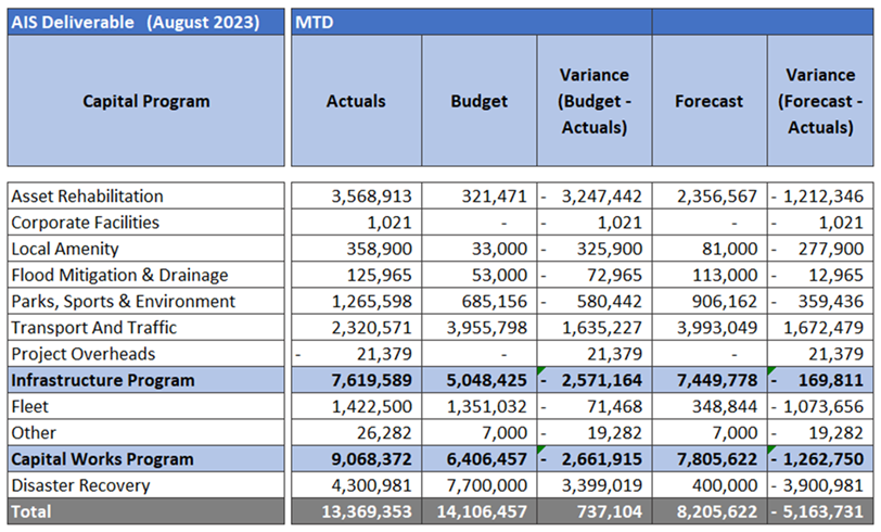
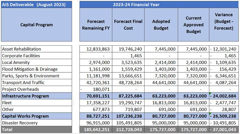
Monthly Program Variances Greater than
$100k (Budget vs Actual)
Asset Rehabilitation overall was $2.91 mil overspent against a budget of $250k for the month of August. This month again was largely attributed to phasing of works and completion of carryover projects from 22-23 FY.
Andrew Josey Gully BR21 works have now reached practical completion with the final variations and claims currently being processed.
Sydney Street Bridge BR21 incurred a further spend of $454k. Works are expected to be completed by end of September.
Trumper St KR 21 works are currently being undertaken by Council’s internal crew with preparations currently underway for the sequencing and timing of the pavement seal works. The works incurred a spend in the month of August of $439k.
Thorn St KR 21 roadworks have progressed with the expectation to be finalised by early September. The project incurred a $423k spend.
South Station Road roadworks incurred a spend of $374k. These works were also carried over from 2022-2023FY and site works are considered practically complete.
Scenic Road sealed road rehabilitation works incurred a spend of $285k. These works originally carried across from 2022-2023FY due to contractor availability, however, are now considered complete.
Southern Sports Field Lighting incurred a $0- spend against a baseline budget of $250,000, these works are currently out for tender and as a result are yet to be awarded.
George and Eileen Hastings Sports Centre Lighting incurred $128k for the month of August against a Nil budget as a result of rephasing of the works to better align with the break period between the sport’s seasons.
Fleet experienced an overall underspend of $33K against a budget allocation of $ 990k for the month of August.
Waste Trucks Commercial Growth incurred a nil spend against a baseline budget of $450k as a result of delay associated with the delivery of a rear loader that was expected to be delivered in August however will now arrive in September.
Parks, Sport & Environment incurred a spend of $369k against a nil budget for the month of August.
Fernbrooke Sports Ground Lighting works are currently underway with the contractor establishing on site and incurring a spend of $227k against a nil budget. Works are currently scheduled to be completed by early November 2023.
Ipswich Cycle Park has incurred a spend of $142k. Works are now considered completed with the carpark now open to the public.
Transport and Traffic had an underspend of $1.87m against an approved budget of $3.05m for the month of August.
Springfield Parkway RU 19 had a spend of $425k against a budget $1.75 mil as a result of works being brought forward earlier in the schedule of the project.
Queen Victoria Parade Bikeway works have incurred a spend of $113k against a nil budget for the month. These works have reached practical completion with only final claims to be processed to finalise these works.
Summary
The Capital Delivery program has continued to deliver above the budget
forecast for a second month in row for the new financial year. The end of
month financial report demonstrates a budget variance for the month in the
order $2.66 mil being overspent, which now totals to $7.98 mil over the current
Year to Date (YTD) Budget.
The August budget was $6.41 mil with the financial actuals achieving $9.07 mil. The expenditure increase for the month was largely attributed to Springfield Parkway Road Upgrade RU19 ($1.75 mil), Springfield Greenbank Arterial Road Upgrade ($846k) and the Waste Truck replacement Program ($957k).
Overall, the August spend followed the trend of the July totals by exceeding the phased budget for the month but being in-line with forecast of completion of the projects carried over from the previous financial year.
Major Projects
Springfield Parkway & Springfield-Greenbank Arterial Road Upgrade
Stage 1 night works and the intersection completion have progressed well with an early opening anticipated in October 2023. The Exit 32 closure was implemented successfully with Off Ramp works and Urban Utilities (UU) Relocations now in full swing.
The Stage 2 100% Design Milestone is under review and Service Relocation designs progressing. Options are being considered to complete an Early Works Package that would allow the service relocations and Civil works to start earlier.
With the end of Stage 1 now in sight, both BMD and ICC are working hard to close this out positively and there is a good focus on site with a number of Milestones being achieved.
· Stage 1 is rapidly nearing completion, with the balance of the asphalt wearing course completed in August which was a significant milestone for the project.
· The new Signalised Intersection is well advanced with signals and mediums installed and the audit for commissioning went well, with the aim being to run a soft/trial commissioning late September with the official opening 1 to 2 weeks later.
· Progressive traffic changes are being made to improve traffic flows as areas are opening up and this is reducing user impacts. Once the signals are operational, travel times will reduce significantly.
· Night works went well and were only extended a few days due to rain, and four (4) to six (6) weeks were shaved from the program as a result. The contractor implemented good noise mitigation and complaints were minimal.
· Line marking is being completed and other works being finalised include landscaping, street lighting, guardrail, signs, mediums and footpaths and another bus shelters was installed in August.
· Upgrading of the three (3) sewer manholes went much better than expected and this has avoided a later traffic switch and costs, but we will still need to address the UU requirement for removal barriers for future maintenance.
· The major remaining works are the extension of the 3.6m culvert above Hymba Yumba and the boulder wall and pathway from Creekside Views. These will progress once the intersection opens and traffic is switched.
· The other major component to be completed is the Eden Station Road Intersection Upgrade with FBS.
· PC Inspections for the Stage have begun and BMD are addressing a number of defects, with some large areas of concrete to be removed due to cracking.
Stage 3
· Service Relocations remain ahead of schedule and Phase 2 of the APA Gas Main relocation is progressing well and conduiting for Communications relocations is almost complete.
· Significant UU works began this month including the new 600m main and 150mm recycled main and the large 10m x 8m by 4m deep valve pit will commence soon. Much of this work is in rock and is quite challenging.
· While scaled down due to service relocations, Civil works have also continued including stormwater, street lighting, medium works and footpaths.
· The Exit 32 closure 7 day trial went well and Off Ramp works are now in full swing. Data indicated that that queuing should not be any worse or possibly better and this turned out to be the case. Only a few complaints were received and while there was some chatter on social media, this was not all negative with one comment being to leave the exit closed.
· We continue to liaise with the QR and Lions to ensure access is maintained to the stadium for match days and Springfield Central station at all times.
Redbank Plains Road Stage 3 Upgrade
Within the last month, progress has been good with significant progress made. Practical completion is currently identified as 24 May 2024 with community consultation remaining as a focus on the project.
Southern Section
· Pavement construction to the south has been completed to allow a forthcoming traffic switch to split north bound and south bound lanes (following completion of resident driveway works), opening up the centre median for construction between Highbury Drive and Argyle St.
Middle Section
· The dividing retaining wall between north and southbound carriageways in the centre of the works Barry to Shannon Streets is progressing well with excavation complete and construction of the lower portion of the L-shaped cantilever wall in progress, including steel fixing and concrete pours.
Northern Section
· To the North, installation (welding of pipe string including testing, and trench excavation, placement and backfill) of a section of the new DN800 trunk watermain has been completed on the Eastern side near Morgan St. Installation of the retaining wall from Morgan to the Kruger roundabout is substantially complete.
Issues with UU allowing shut down of the trunk main will almost certainly affect installation to allow commissioning of the new realigned main. Details are currently being worked out to determine the extent of this disruption to the project, which will lead to resequencing of works planned in the Northern section.
Expenditure for the month of August comprised of a financial reversal as previously noted within this report. This resulted in an underspend of $2.2mil because of a claim for advanced funds being rectified for non-receival, as well as the August claim from contractor not being received. These costs however are expected to fall within the September forecast and are expected to bring the project back in line with the forecast budget.
Passenger Transport Accessible Infrastructure Program (PTAIP) - Bus Stop Program
As mentioned in the July report, all 2022-2023 FY bus stops with Passenger Transport Accessible Infrastructure Program (PTAIP) grant funding have been completed with the exception of Reif Street. Council is continuing to work with Urban Utilities to approve a risk-based approach for a reduced water main coverage for this project. TransLink have confirmed the approval of an extension of time to the PTAIP grant until 30 June 2024 to complete.
Design has continued with the current 2023-2024 FY bus stop program with the locations still being reviewed by TransLink for approval of grant funding.
The list of stops includes:
· Booval Station
· Brisbane Street (Near Keogh St)
· Mount Crosby Road (Near Croydon St) x 2 Sites
· Grande Ave (Near Oak Lead Dr) x 2 Sites
· Jones Road (Near Augusta Pkwy)
· Lakeside Ave (Near Burlington Tce)
· Stubbin St (Near Wade St)
· Springfield Lakes Bvd (Near Lakes Entrance Dr)
· Hill Street (Near Phie St) x 2 Sites
· Lawrie Drive (Near Milgate St)
· Workshops Street (At Sutton Park)
· Blackstone Rd (Near Whitehill Rd)
Grant Projects Scheduled for delivery this FY (includes
Multi-year Funding)
NOTE: Below table includes reporting on capital construction projects only
– it does not include Design Only or Operational projects.
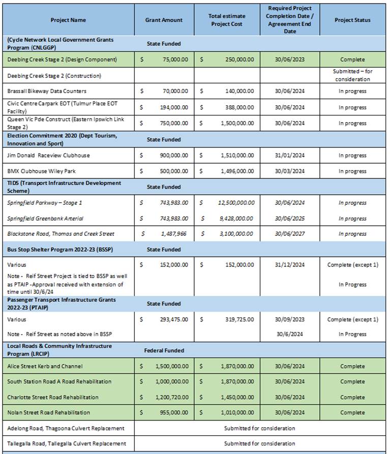
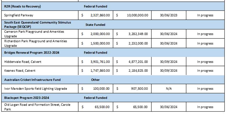
As noted above in the (PTAIP) Bus Stop Program –
TransLink are continuing to evaluate all
15 locations that have been put forward for consideration for grant funding
within the 2023-2024 FY.
Master Schedule status of Practical Completion milestone for August (inclusive of emergent projects)
|
Milestone |
August Actual |
Actuals Year to date |
Target for 23/24 |
|
Practical Completion |
4 |
16 |
49 |
As at end of August, project completion status shows 16 projects have reached practical completion from a total of 49 projects that are scheduled for delivery this FY.
Current status of Construction projects for 23-24 FY
|
Current Status of Projects |
Count of Projects |
|
Concept Design |
6 |
|
Detail Design |
3 |
|
Handed Over for Execution |
8 |
|
Construction in Progress |
16 |
|
Practically Complete |
16 |
The data shown above for status of projects scheduled for delivery in the 2023-2024 FY. Majority of projects scheduled for delivery this financial year have been designed and handed over for construction, with only 9 projects still in design stage and yet to be Issued For Construction (IFC).
Legal IMPLICATIONS
This report and its recommendations are consistent with the following legislative provisions:
Local Government Act 2009
policy implications
Nil
RISK MANAGEMENT IMPLICATIONS
The Asset and Infrastructure Services Department has a departmental risk register that includes the delivery of the capital program. The leadership team of the department continues to monitor our risk in relation to this and takes mitigation action where necessary.
Financial/RESOURCE IMPLICATIONS
No financial / resource implications
COMMUNITY and OTHER CONSULTATION
No community consultation was required in relation to this report.
The Stakeholder Management Branch of the Asset and Infrastructure Services Department engages extensively with the community impacted by our works to ensure that they are informed in advance of works, communicated with during works and ensure that any issues that arise are managed effectively.
Conclusion
The Asset and Infrastructure Services Department is committed to delivering high quality infrastructure for the community.
HUMAN RIGHTS IMPLICATIONS
|
HUMAN RIGHTS IMPACTS |
|
RECEIVE AND NOTE REPORT |
|
|
Attachments and Confidential Background Papers
|
1. |
Capital Delivery Report August 2023 ⇩ |
Tom Reynolds
Acting Principal Officer (Program Management)
I concur with the recommendations contained in this report.
Graeme Martin
Manager, Capital Program Delivery
I concur with the recommendations contained in this report.
Matt Anderson
General Manager, Asset and Infrastructure Services
“Together, we proudly enhance the quality of life for our community”
|
Growth Infrastructure and Waste Committee Meeting Agenda |
12 October 2023 |
ITEM: 8
SUBJECT: Exercise Of Delegation Report
AUTHOR: Manager, Development Planning
DATE: 19 September 2023
This is a report concerning applications that have been determined by delegated authority for the period 17 August 2023 to 20 September 2023.
That the Exercise of
Delegation report for the period 17 August 2023 to
20 September 2023, be received and the contents noted.
There are no related parties associated with the recommendation as the development applications have already been determined.
A Trusted and Leading Organisation
The following delegations (and associated sub-delegations) contain a requirement for the noting of applications determined by delegated authority:
· Approval of Plans for Springfield
· Determination of Development Applications, Precinct Plans, Area Development Plans and Related Matters
· Exercise the Powers of Council under the Economic Development Act 2012
· Implementation of the Planning and Development Program
· Exercise the Powers of Council under the Planning Act 2016
This report and its recommendations are consistent with the following legislative provisions:
Local Government Act 2009
Planning Act 2016
Economic Development Act 2012
There are no risk management implications associated with this report.
|
HUMAN RIGHTS IMPACTS |
|
RECEIVE AND NOTE REPORT |
|
The recommendation states that the report be received and the contents noted. The decision to receive and note the report does not limit human rights. Therefore, the decision is compatible with human rights. |
There are no resourcing or budget implications associated with this report.
The contents of this report did not require any community consultation. In the event that the development applications listed in this report triggered ‘impact assessment’ pursuant to the Ipswich Planning Scheme, public notification was undertaken as part of the development application process in accordance with any legislative requirements and matters raised in any submissions and were addressed in the respective development assessment reports.
The Planning and Regulatory Services
Department is responsible for the assessment and determination of development
applications. Attachment 1 to this report provides a list of development
applications that were determined by delegated authority for the period
17 August 2023 to 20 September 2023.
|
1. |
Exercise of Delegation Report ⇩ |
Anthony Bowles
Manager, Development Planning
I concur with the recommendations contained in this report.
Brett Davey
General Manager Planning and Regulatory Services
“Together, we proudly enhance the quality of life for our community”
|
Growth Infrastructure and Waste Committee Meeting Agenda |
12 October 2023 |
ITEM: 9
SUBJECT: Planning and Environment Court Action Status Report
AUTHOR: Manager, Development Planning
DATE: 19 September 2023
Executive Summary
This is a report concerning a status update with respect to current court actions associated with development planning applications.
Recommendation
That the Planning and Environment Court Action status report be received and the contents noted.
RELATED PARTIES
The related parties, being the appellants associated with any court actions, are detailed in the attachment to this report.
IFuture Theme
Vibrant and Growing
Safe, Inclusive and Creative
Natural and Sustainable
A Trusted and Leading Organisation
DISCUSSION
Whilst this report outlines a specific list of development application related court actions, from time to time, Council will be engaged in prosecutions relating to development offences and other matters. Owing to the nature of these prosecutions, these matters are not generally listed in the attached court action report. However substantial matters will be presented to the Growth, Infrastructure and Waste Committee using this report from time to time.
Further information on these appeals can be found on the Planning and Environment Court web site.
Legal/Policy Basis
This report and its recommendations are consistent with the following legislative provisions:
Local Government Act 2009
Planning Act 2016
Planning and Environment Court Act 2016
RISK MANAGEMENT IMPLICATIONS
There are no risk management implications associated with this report.
HUMAN RIGHTS IMPLICATIONS
|
HUMAN RIGHTS IMPACTS |
|
RECEIVE AND NOTE REPORT |
|
The recommendation states that the report be received and the contents noted. The decision to receive and note the report does not limit human rights. Therefore, the decision is compatible with human rights.
|
Financial/RESOURCE IMPLICATIONS
N/A
COMMUNITY and OTHER CONSULTATION
The contents of this report did not require any community consultation.
Conclusion
The Planning and Regulatory Services Department are currently involved with several Planning and Environment Court and Supreme Court matters. Attachment 1 to this report provides a current status with respect to these matters.
Attachments and Confidential Background Papers
|
1. |
PLANNING AND ENVIRONMENT COURT ACTION STATUS REPORT ⇩ |
Anthony Bowles
Manager, Development Planning
I concur with the recommendations contained in this report.
Brett Davey
General Manager Planning and Regulatory Services
“Together, we proudly enhance the quality of life for our community”
|
Growth Infrastructure and Waste Committee Meeting Agenda |
12 October 2023 |
ITEM: 10
SUBJECT: Sub-Regional Waste Alliance - MRF Investment Decision
AUTHOR: Manager, Resource Recovery
DATE: 11 September 2023
Executive Summary
This paper serves as the non-confidential holding paper for the detailed tender evaluation and business case for the potential establishment of Greenovate Pty Ltd as a Council owned beneficial enterprise to manage the future Sub Regional Alliance Material Recovery Facility.
The full reports are attached in the confidential attachment the Sub Regional Alliance Material Recovery Facility – Confidential Report - Tender Evaluation, Business Case and Establishment of Greenovate Pty Ltd Beneficial Enterprise.
REASON FOR CONFIDENTIALITY
It is recommended that this report be considered in a closed session pursuant to Section 254J of the Local Government Regulation 2012 (Qld) for the reason(s) that the matter involves:
Section 254J (3) (g) negotiations relating to a commercial matter involving the local government for which a public discussion would be likely to prejudice the interests of the local government
It is considered necessary to take the discussion of this report into a closed session as the confidential attachments contain information relating to contracts that may be made by Council as well as commercial-in-confidence financial information.
Additionally, as the Council owned commercial entity, that will be created pursuant to the report’s recommendations, will operate in a competitive commercial environment into the future, maintaining confidentiality of future projected operating cost is vital for its interests.
Recommendation/s
A. That the recommendations contained in confidential Attachment 1 be adopted.
B. That due to the confidential nature of the recommendations, that once adopted by Council, the recommendations be made public.
RELATED PARTIES
· There was no declaration of conflicts of interest
· Shortlisted Respondents
· Commonwealth Department of Agriculture, Water & Environment
· Queensland Government Department of Environment & Science
· Queensland Government Department of State Development, Tourism & Innovation
· Queensland Treasury Corporation
· Ipswich City Council
· Redland City Council
· Lockyer Valley Regional Council
· Local Government Association of Queensland
· South East Queensland Council of Mayors
· Waste Management and Resource Recovery Association of Australia
· Waste & Recycling Industry Queensland
· Australian Consumer and Competition Commission
· Waste consultancy sector
ifuture Theme
Natural and Sustainable
Purpose of Report/Background
The purpose of this report is to present a resolution to Council to further the Sub-Regional Alliance’s tendering exercise through to its final Stage 3 gate, to progress the establishment of the new Greenovate business that will operate the proposed new Material Recovery Facility (MRF).
ATTACHMENTS
See at end of document.
The attachments to this report are identical to the Logan and Redland Councils except for the Individual Cost Benefit Analysis - Ipswich City Council, that sits in the Confidential Report. Due to the shared nature of these attachments and that references to Attachments 1 and 2 are called out in the shared Confidential Report. They are named separately for this report but should be treated as attachments to the Confidential Report.
Legal IMPLICATIONS
This report and its recommendations are consistent with the following legislative provisions:
Local Government Regulation 2012
Local Government Act 2009
This procurement process is being undertaken in accordance with the provisions of the Local Government Regulation 2012, legal advice and probity protocols provided by the Alliance’s legal and probity adviser.
The proposal before Council has given regard to Federal, State and Local Government waste and recycling related policies, strategies and plans.
policy implications
This report and its recommendations are consistent with the following legislative provisions:
Local Government Regulation 2012
This procurement process is being undertaken in accordance with the provisions of the Local Government Regulation 2012, legal advice and probity protocols provided by the Alliance’s legal and probity adviser.
The proposal before Council has given regard to Federal, State and Local Government waste and recycling related policies, strategies, and plans.
RISK MANAGEMENT IMPLICATIONS
This information is confidential and is included in the confidential attachments to this report.
Financial/RESOURCE IMPLICATIONS
This information is confidential and is included in the confidential attachment to this report.
COMMUNITY and OTHER CONSULTATION
The project team comprised of staff representatives from the Alliance Councils have been liaising regularly since the commencement of the project to further the Sub-Regional Alliance.
The public website provides an overview of the Alliance project remains active at www.subregionalwastealliance.com.au .
Information on the Alliance process will be updated on the website and through other forums following each Council’s consideration of the acceptable operating parameter evaluation report and recommendations.
Conclusion
Detail for this section is contained the Sub Regional Alliance Material Recovery Facility – Confidential Report - Tender Evaluation, Business Case and Establishment of Greenovate Pty Ltd Beneficial Enterprise.
HUMAN RIGHTS IMPLICATIONS
|
HUMAN RIGHTS IMPACTS |
|
NON-DISCRETIONARY DECISION |
|
Recommendation 1 of the confidential report “Sub Regional Alliance Material Recovery Facility – Confidential Report - Tender Evaluation, Business Case and Establishment of Greenovate Pty Ltd Beneficial Enterprise”, Council will be entering a Beneficial Enterprise and as such must follow the legislation.
Council has no ability to act differently/make a different decision because of that requires Council to operate under this mechanism. Therefore, while the proposed decision may not be compatible with human rights Council’s decision will not be unlawful under the Human Rights Act 2019. Noting that this actual decision does not impact Human Rights.
|
Attachments and Confidential Background Papers
David McAlister
Manager, Resource Recovery
I concur with the recommendations contained in this report.
Kaye Cavanagh
General Manager (Environment and Sustainability)
“Together, we proudly enhance the quality of life for our community”