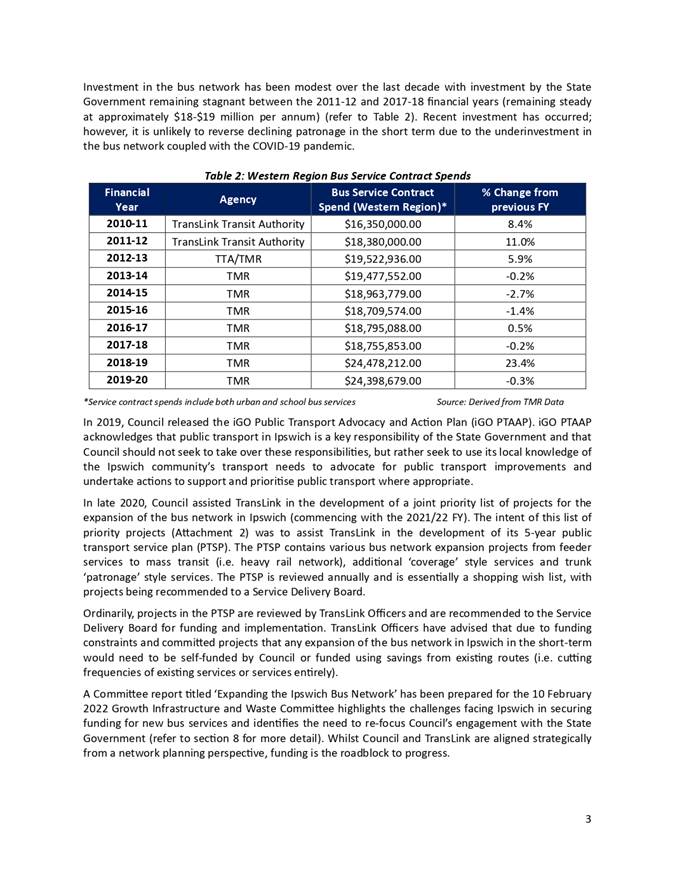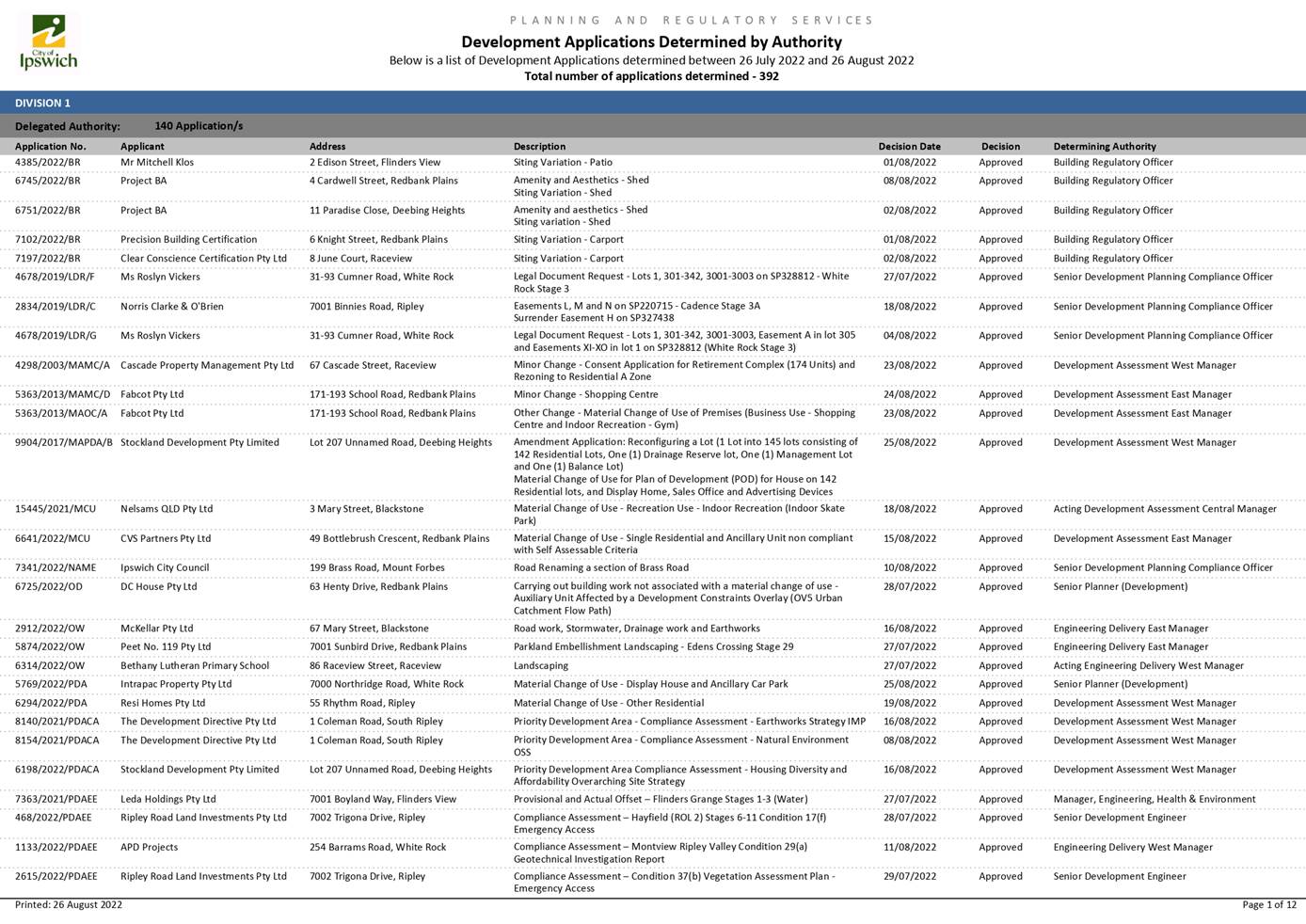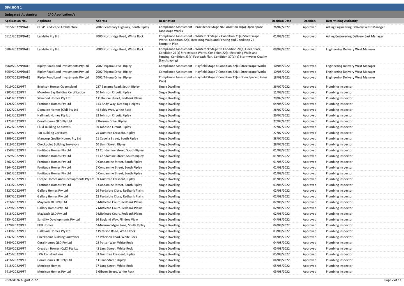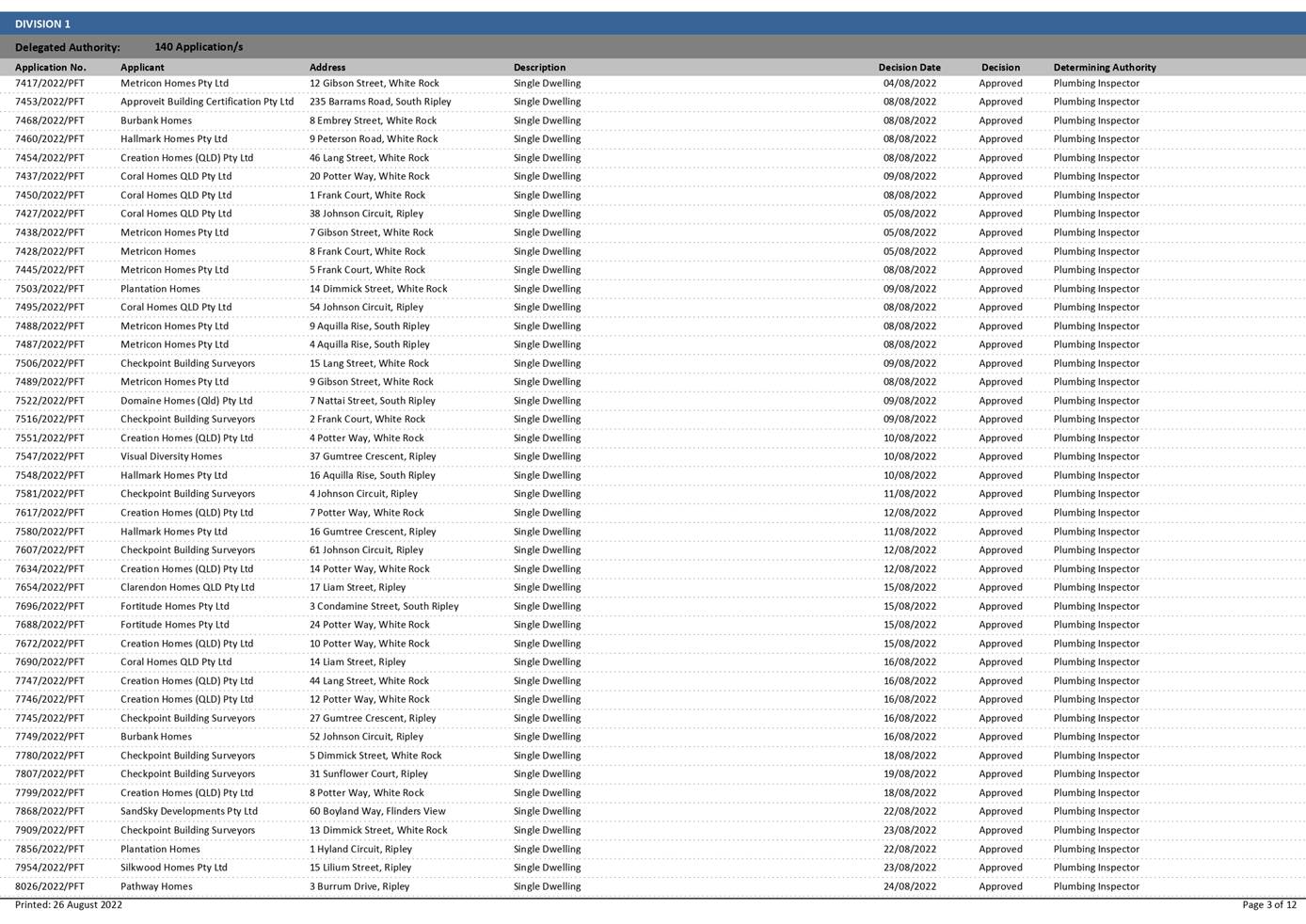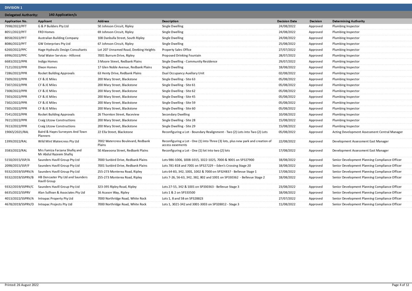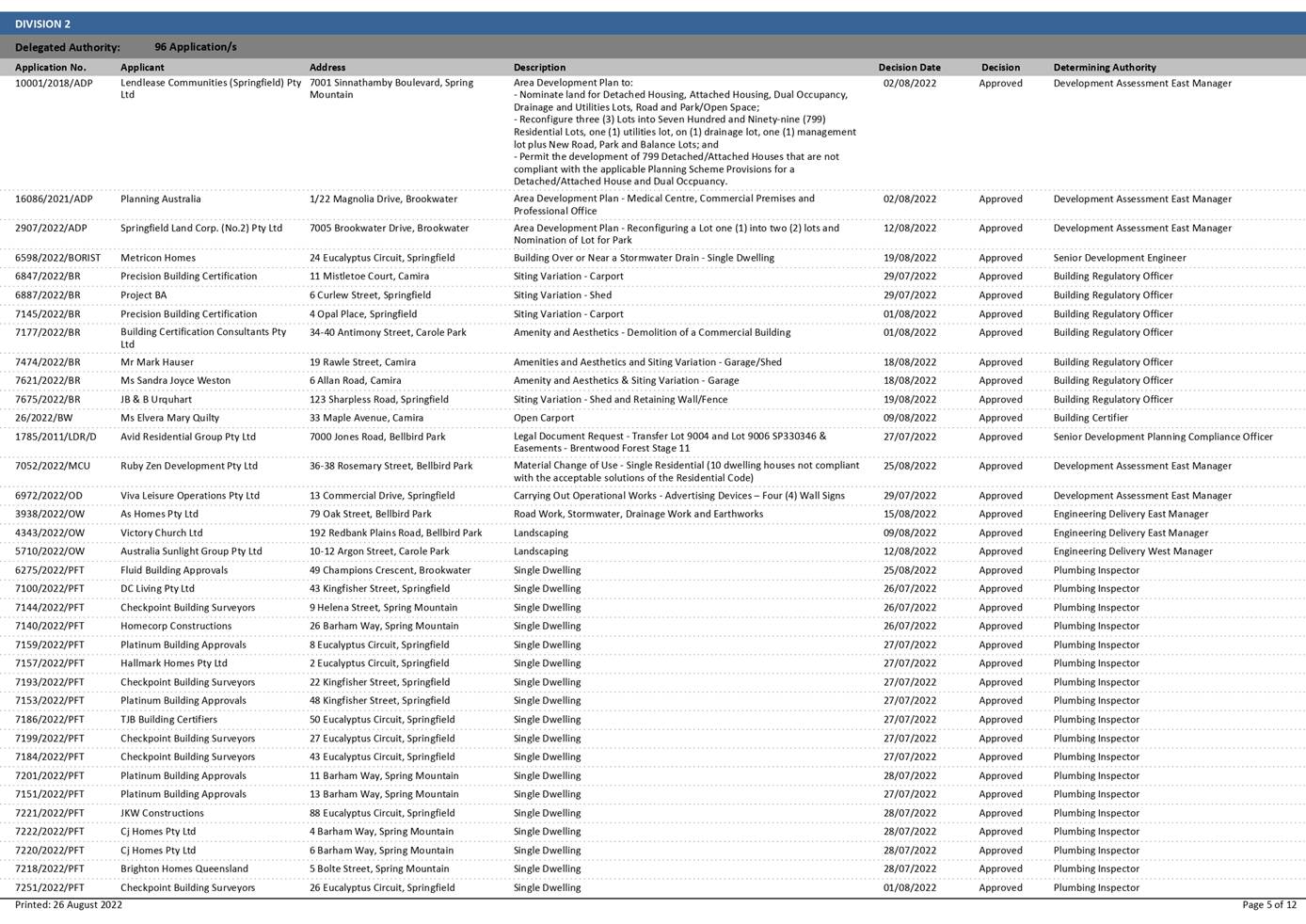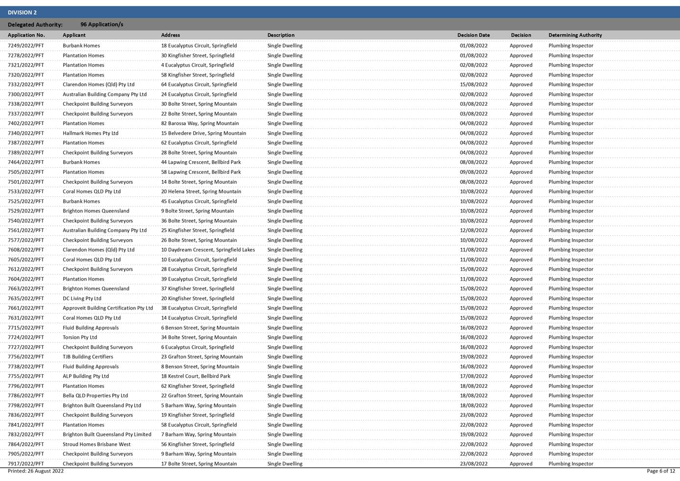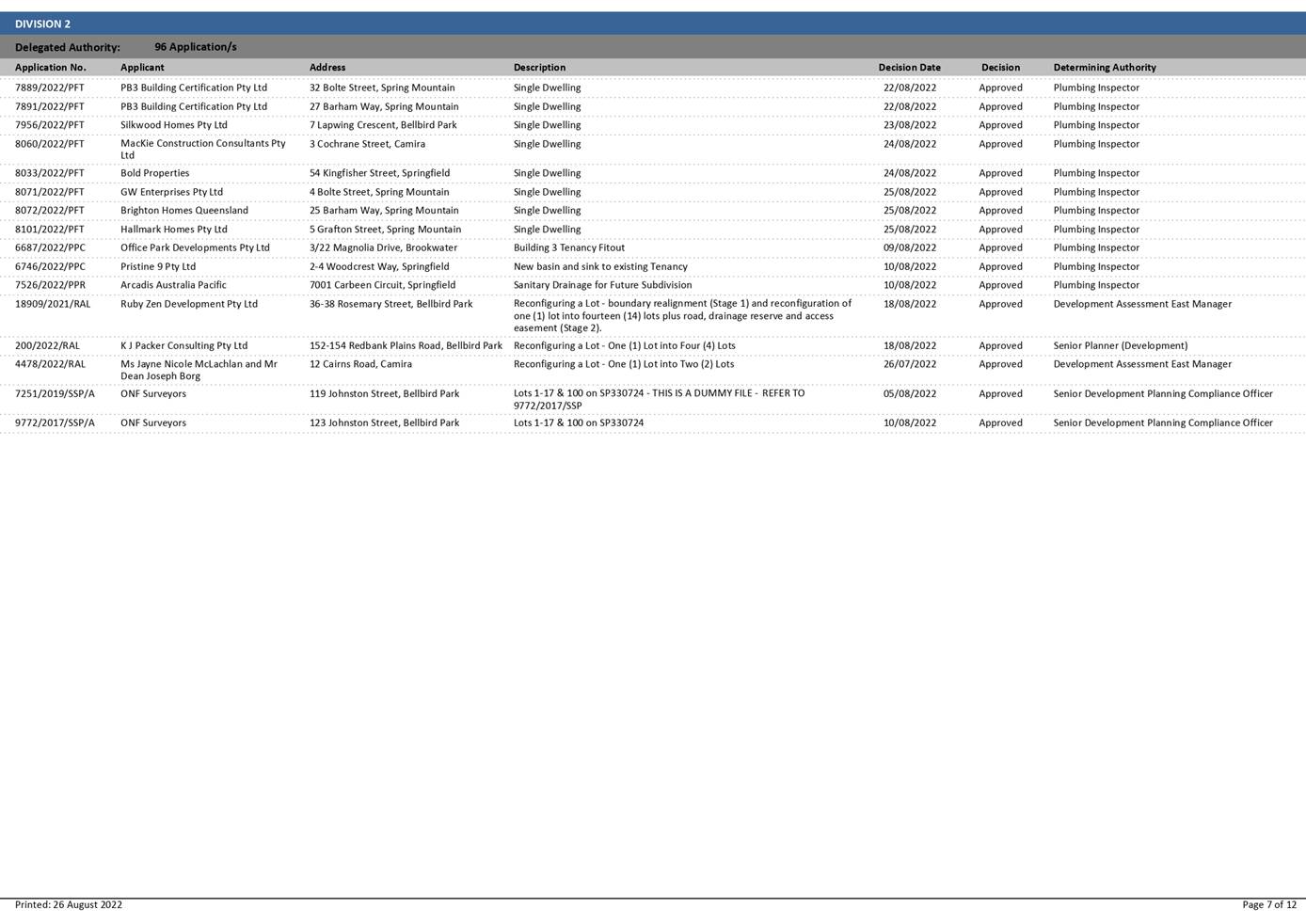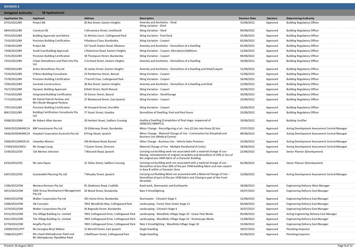
IPSWICH
CITY
COUNCIL
AGENDA
of the
Growth Infrastructure and Waste Committee
Held in the Council Chambers
8th floor – 1 Nicholas Street
IPSWICH QLD 4305
On Thursday, 15 September 2022
At 9.00 am
IPSWICH
CITY
COUNCIL
AGENDA
of the
Growth Infrastructure and Waste Committee
Held in the Council Chambers
8th floor – 1 Nicholas Street
IPSWICH QLD 4305
On Thursday, 15 September 2022
At 9.00 am
|
MEMBERS OF THE Growth Infrastructure and Waste Committee |
|
|
Mayor Teresa Harding (Chairperson) Councillor Paul Tully (Deputy Chairperson) |
Councillor Sheila Ireland Deputy Mayor Jacob Madsen Councillor Marnie Doyle Councillor Andrew Fechner Councillor Kate Kunzelmann Councillor Russell Milligan Councillor Nicole Jonic |
|
Growth Infrastructure and Waste Committee Meeting Agenda |
15 September 2022 |
Growth Infrastructure and Waste Committee AGENDA
9.00 am on Thursday, 15 September 2022
Council Chambers
|
Item No. |
Item Title |
Page No. |
|
|
Welcome to Country or Acknowledgment of Country |
|
|
|
Declarations of Interest |
|
|
|
Business Outstanding Matters laid on the table at the Growth Infrastructure and Waste Committee of 11 August 2022 • Response to Petition - Leash Free Dog Area, Camira Recreation Park • Redbank Plains Library Additional Community Meeting Space - Response to Notice of Motion
|
|
|
1 |
Response to Petition - Leash Free Dog Area, Camira Recreation Park |
9 |
|
2 |
Redbank Plains Library Additional Community Meeting Space - Response to Notice of Motion |
37 |
|
|
Confirmation of Minutes |
|
|
3 |
Confirmation of Minutes of the Growth Infrastructure and Waste Committee No. 2022(07) of 11 August 2022 |
51 |
|
|
Officers’ Reports |
|
|
4 |
Development Application - 2295/2020/VA - Variation Application seeking preliminary approval to vary the Planning Scheme from Rural Constrained - Ripley Valley Zone and Future Urban Zone, at Siddans Road Deebing Heights |
63 |
|
5 |
Development Application Recommendation - Temporary Accommodation (Camping Ground and Caravan Park) at One Mile |
126 |
|
6 |
Regionally Significant Project Proposal - Ipswich Bus Network Expansion |
170 |
|
7 |
Adoption of the three year new kerb and channel capital program |
206 |
|
8 |
Alternative Road Surfacing Options |
211 |
|
9 |
Infrastructure and Environment Department Capital Delivery Report July 2022 |
218 |
|
10 |
Planning and Environment Court Action Status Report |
247 |
|
11 |
Exercise Of Delegation Report |
254 |
|
|
Notices of Motion |
|
|
|
Matters Arising |
|
** Item includes confidential papers
Growth Infrastructure and Waste Committee NO. 8
15 September 2022
AGENDA
Welcome to Country or Acknowledgement of Country
DECLARATIONS OF INTEREST IN MATTERS ON THE AGENDA
BUSINESS
OUTSTANDING
Matters laid on the table at the Growth Infrastructure and Waste Committee of 11 August 2022
• Response to Petition - Leash Free Dog Area, Camira Recreation Park
• Redbank Plains Library Additional Community Meeting Space - Response to Notice of Motion
1. Response to Petition - Leash Free Dog Area, Camira Recreation Park
This is a report concerning a petition received from the local community requesting alterations to the existing leash free dog area located at Camira Recreation Park, Camira.
Recommendation
A. That the leash free dog area within the Camira Recreation Park remain in its current configuration without further expansion.
B. That further planning be undertaken for the Camira Recreation Park, including community engagement, to seek the sentiment of sport and recreation needs of the community.
C. That the chief petitioner be advised of the outcome of this report.
2. Redbank Plains Library Additional Community Meeting Space - Response to Notice of Motion
This is a report providing a response to a Notice of Motion moved by Deputy Mayor Jacob Madsen at the Council Meeting of 19 May 2022:
That a design be prepared and costed for conversion of the former Mobile Library Garaged at Redbank Plains Library with said design to focus on delivery of:
a) Community Meeting space with afterhours access
b) External landscaping to allow appropriate pathways to afterhours access and use by community on special occasions
Recommendation
That the report Redbank Plains Library Additional Community Meeting Space – Response to Notice of Motion be received and the contents noted.
Confirmation of Minutes
3. Confirmation of Minutes of the Growth Infrastructure and Waste Committee No. 2022(07) of 11 August 2022
Recommendation
That the Minutes of the Meeting held on 11 August 2022 be confirmed.
Officers’ Reports
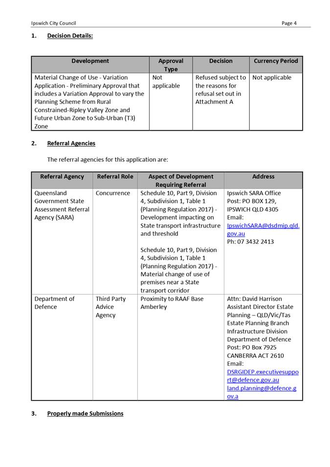
4. Development Application - 2295/2020/VA - Variation Application seeking preliminary approval to vary the Planning Scheme from Rural Constrained - Ripley Valley Zone and Future Urban Zone, at Siddans Road Deebing Heights
This is a report concerning a development application (Variation Application) seeking a Preliminary Approval that includes a Variation Approval to vary the Planning Scheme from Rural Constrained-Ripley Valley Zone and Future Urban Zone to Sub-Urban (T3) Zone, over land located at 146 and 184 Siddans Road, Deebing Heights.
The application requires determination by Council owing to a request that was made by the applicant (through a registered lobbyist). More specifically, the applicant wrote to Council’s Chief Executive Officer (CEO) and requested that a determination be made that the scale, scope, nature and sensitivity of the application warrants a Council decision. Upon considering the applicant’s request, the CEO and General Manager - Planning and Regulatory Services agreed that the nature of the application warrants a Council decision in line with section 9 of the Ipswich City Council Framework for Development Applications and Related Activities Policy.
The proposed development has been assessed having regard to the applicable assessment benchmarks, matters prescribed by regulation and other relevant matters pursuant to s.45(5) of the Planning Act.
The proposed Variation Application seeking a Preliminary Approval that includes a Variation Approval to vary the Planning Scheme cannot be supported in accordance with section 5 and section 60 of the Planning Act 2016, as the proposal does not advance the purpose of the Planning Act 2016 and conflicts with the assessment benchmarks, matters prescribed by regulation and other relevant matters.
Recommendation
That Council refuse Development Application No. 2295/2020/CA, being a Variation Application - Preliminary Approval that includes a Variation Approval to vary the Planning Scheme from Rural Constrained-Ripley Valley Zone and Future Urban Zone to Sub-Urban (T3) Zone, for the reasons as contained in Attachment 2 of this report.
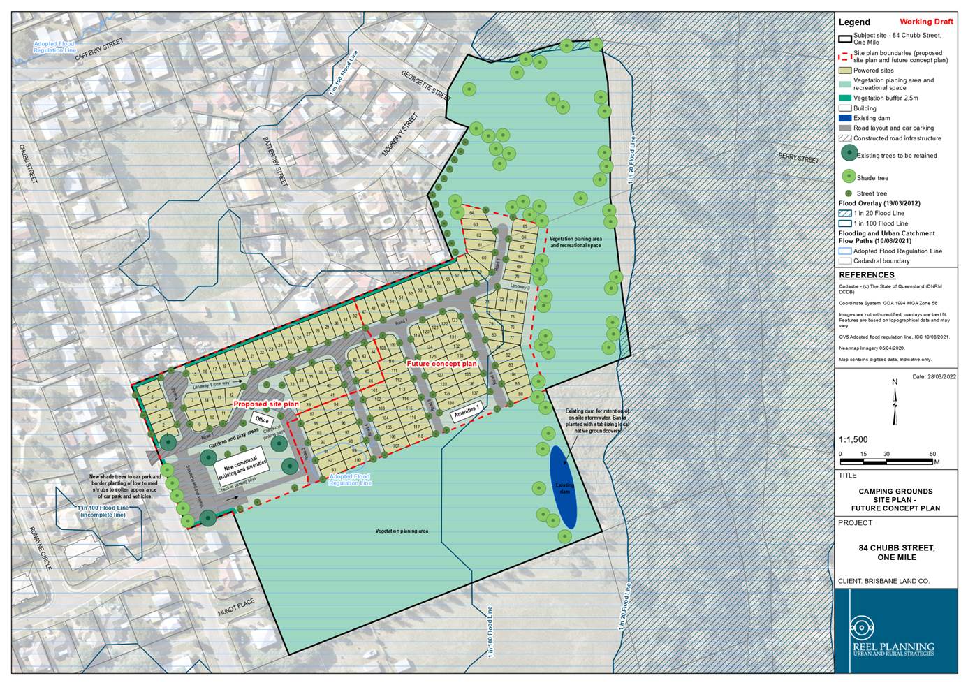
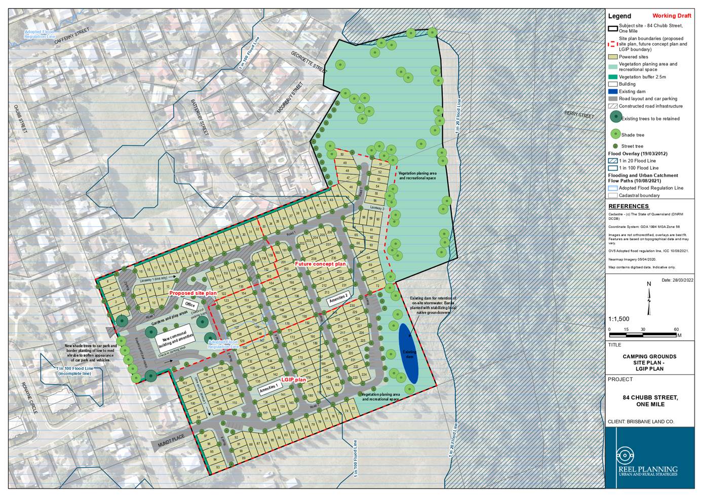
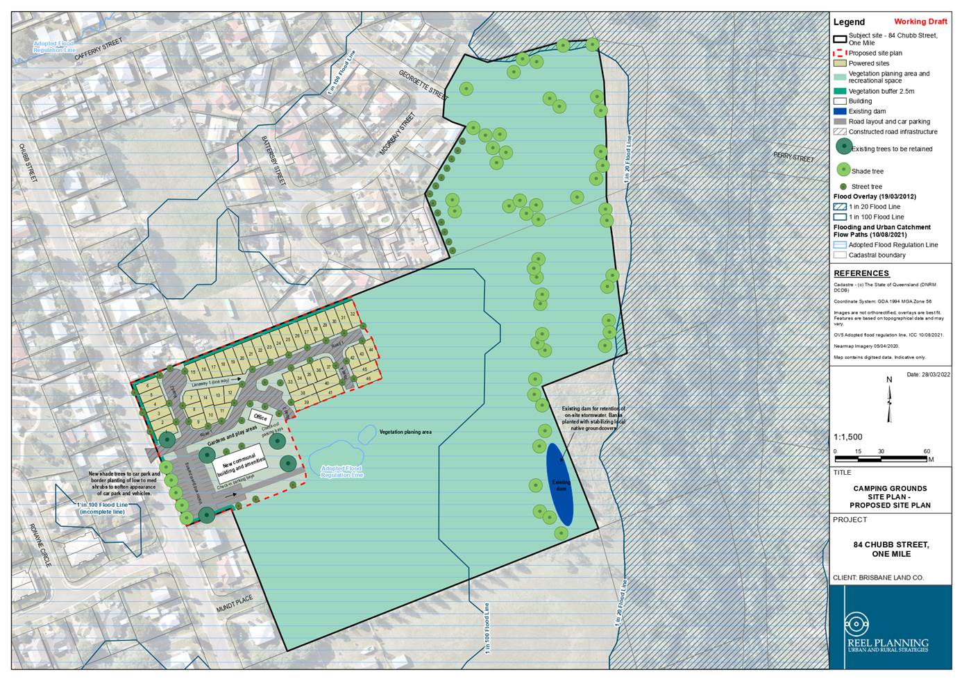
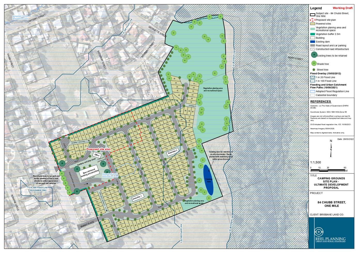
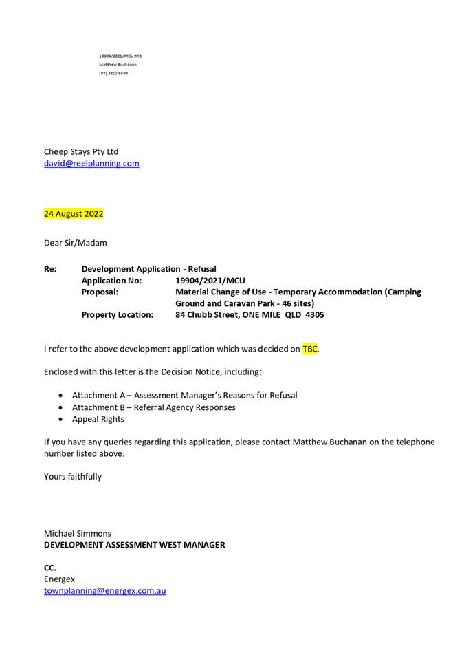
5. Development Application Recommendation - Temporary Accommodation (Camping Ground and Caravan Park) at One Mile
This is a report concerning an application seeking approval for a Material Change of Use – Temporary Accommodation (Camping Ground and Caravan Park – 46 sites) at 84 Chubb Street, One Mile.
The subject application requires review and determination by the Growth, Infrastructure and Waste Committee in accordance with the Framework for Development Applications and Related Activities Policy as more than 20 properly made submissions objecting to the proposed development were received.
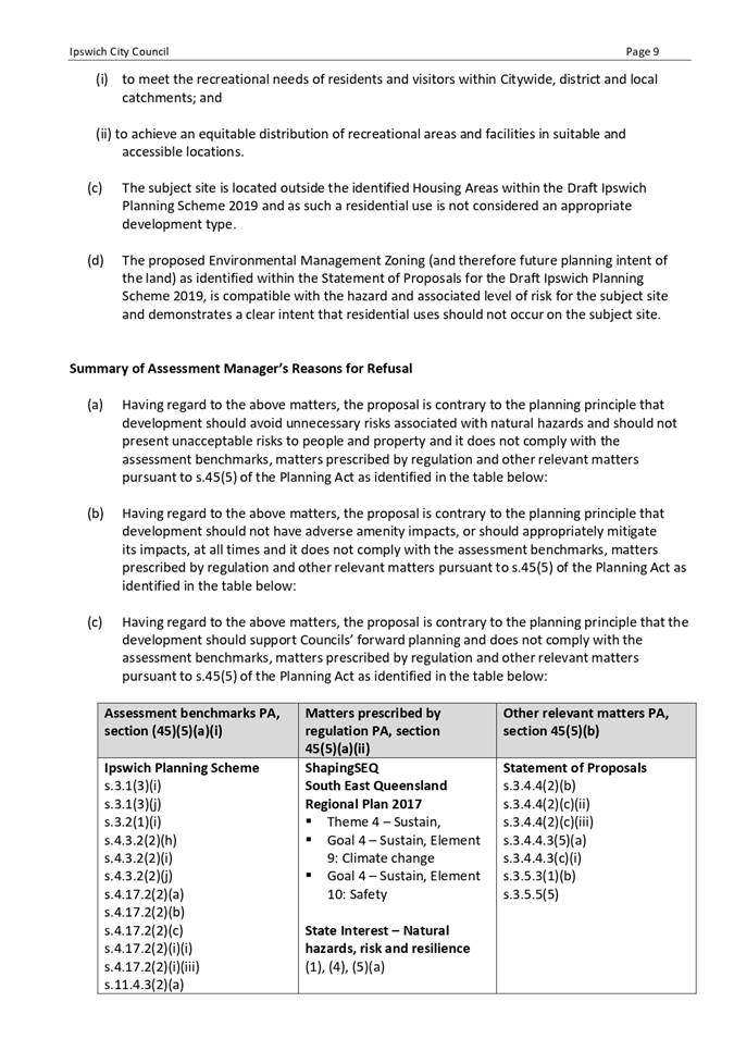
The proposed development has been assessed with regard to the applicable assessment benchmarks and it was determined that it cannot be supported in accordance with section 5 and section 60 of the Planning Act 2016, as the proposal does not advance the purpose of the Planning Act, conflicts with the applicable codes of the Ipswich Planning Scheme and the other relevant matters applicable to the application.
Recommendation
That Council refuse Development Application No. 19904/2021/MCU for the reasons as contained in Attachment 2 of this report.
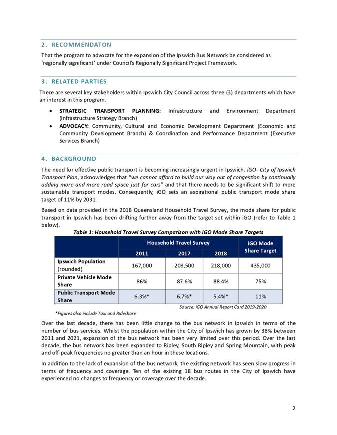
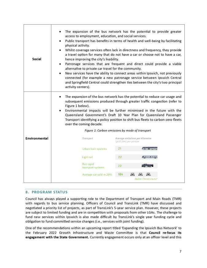
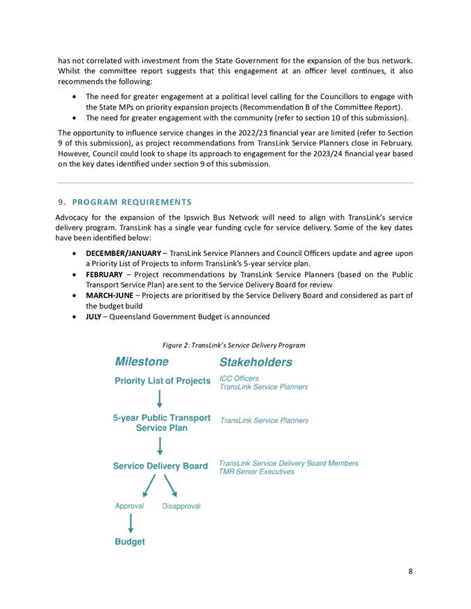
6. Regionally Significant Project Proposal - Ipswich Bus Network Expansion
This is a report concerning the
Ipswich Bus Network Expansion Project and the opportunity to declare this as a
project of regional significance.
Recommendation
A. That Council accept the Ipswich Bus Network Expansion project as regionally significant.
B. That the Ipswich Bus Network Expansion project be taken to the next Advocacy Steering Group meeting for consideration of the appropriate advocacy effort.
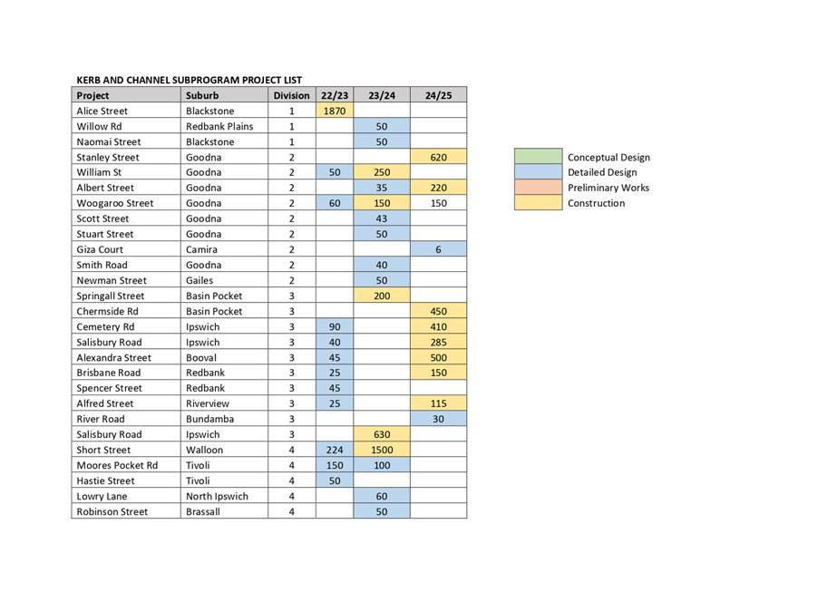
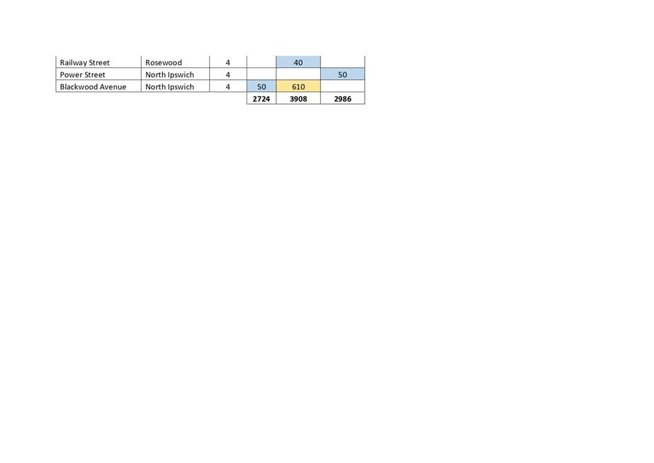
7. Adoption of the three year new kerb and channel capital program
This is a report concerning the three-year new kerb and channel capital program.
Council officers have applied the statistical methodology in combination with input from the community via the Divisional Councillors to finalise the three-year kerb and channel program.
The recommended program provides a better outcome for the community and is deliverable within the adopted three-year capital program and budget.
Recommendation
That Council adopt the three-year program for new Kerb and Channel as specified in the attachment to this report.
8. Alternative Road Surfacing Options
This is a report concerning industry information requested from the Queensland Branch of the Australian Flexible Pavements Association (AfPA) of the residential road resurfacing treatments available. The report is developed in continuance of the Notice of Motion – Spray Seal Maintenance Treatments Report.
Recommendation
That the report on alternative road surfacing options be received and the contents noted.
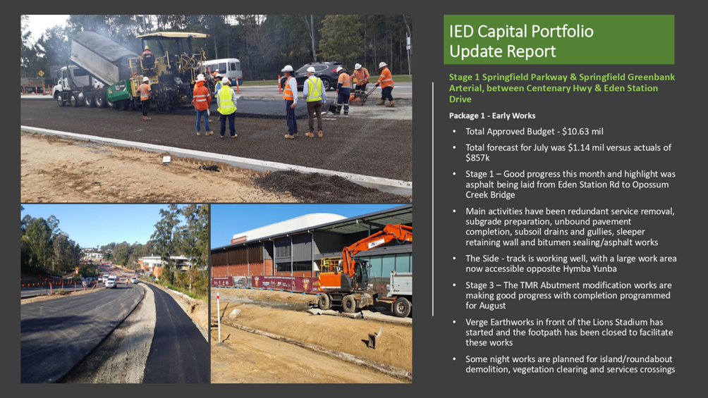
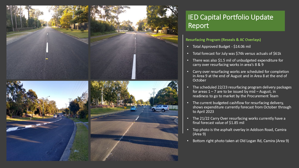
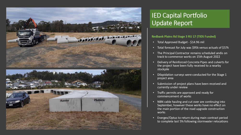
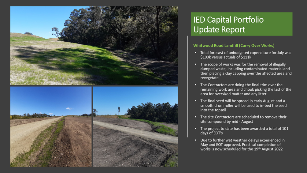
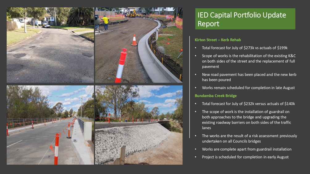
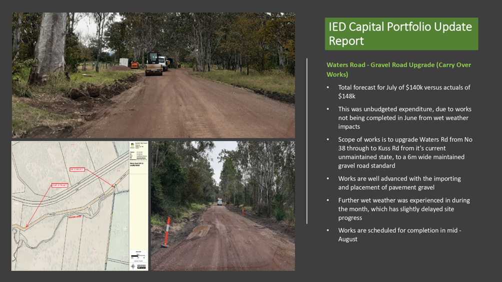
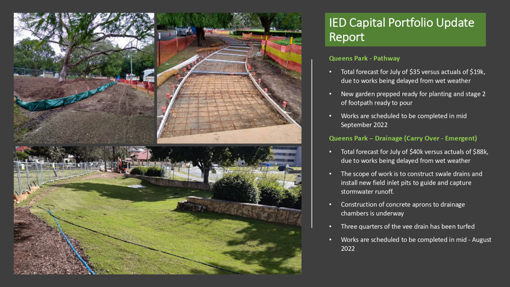
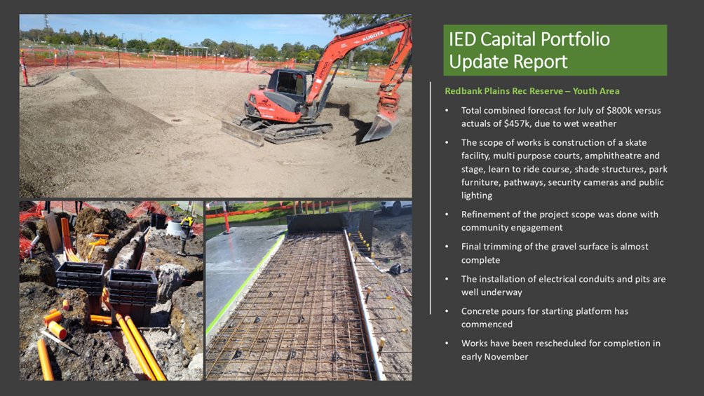
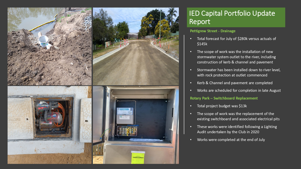
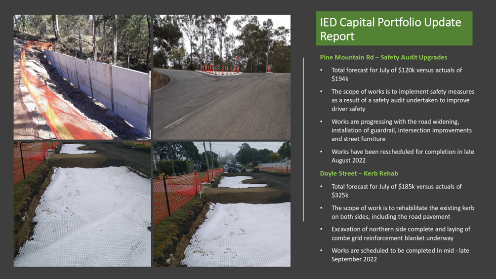
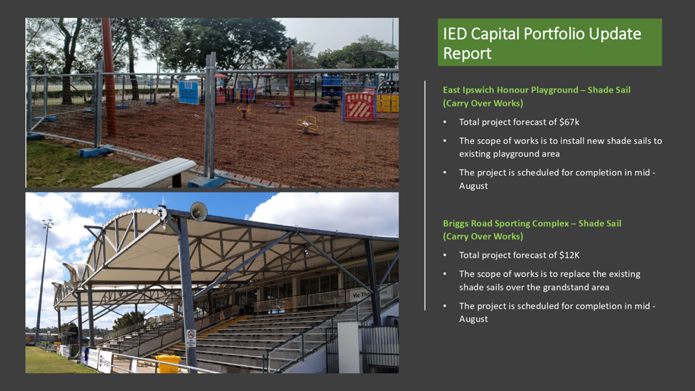
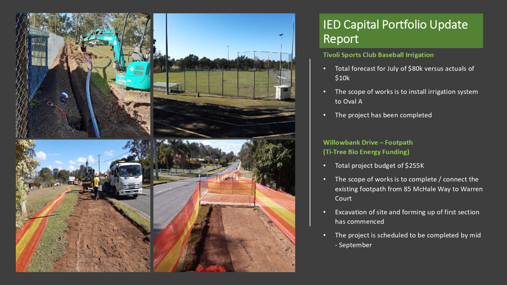
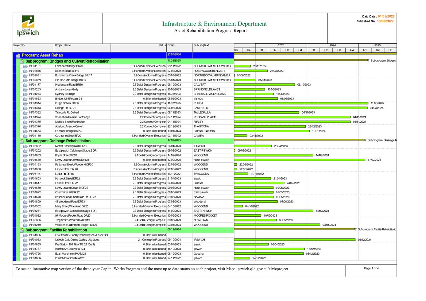
9. Infrastructure and Environment Department Capital Delivery Report July 2022
This is a report concerning the performance of the capital delivery by the Infrastructure and Environment Department for the month of July 2022.
Recommendation
That the report be received and the contents noted.
10. Planning and Environment Court Action Status Report
This is a report concerning a status update with respect to current court actions
associated with development planning applications.
Recommendation
That the report be received and the contents noted.
11. Exercise Of Delegation Report
This is a report concerning applications that have been determined by delegated
authority for the period 26 July 2022 to 26 August 2022.
Recommendation
That the report be received and the contents noted.
NOTICES OF MOTION
MATTERS ARISING
|
Growth Infrastructure and Waste Committee Meeting Agenda |
15 September 2022 |
ITEM: 1
SUBJECT: Response to Petition - Leash Free Dog Area, Camira Recreation Park
AUTHOR: Planning Officer (Open Space)
DATE: 6 September 2022
This is a report concerning a petition received from the local community requesting alterations to the existing leash free dog area located at Camira Recreation Park, Camira.
A. That the leash free dog area within the Camira Recreation Park remain in its current configuration without further expansion.
B. That further planning be undertaken for the Camira Recreation Park, including community engagement, to seek the sentiment of sport and recreation needs of the community.
C. That the chief petitioner be advised of the outcome of this report.
RELATED PARTIES
Nil conflicts of interest have been identified
ifuture Theme
Vibrant and Growing
Purpose of Report/Background
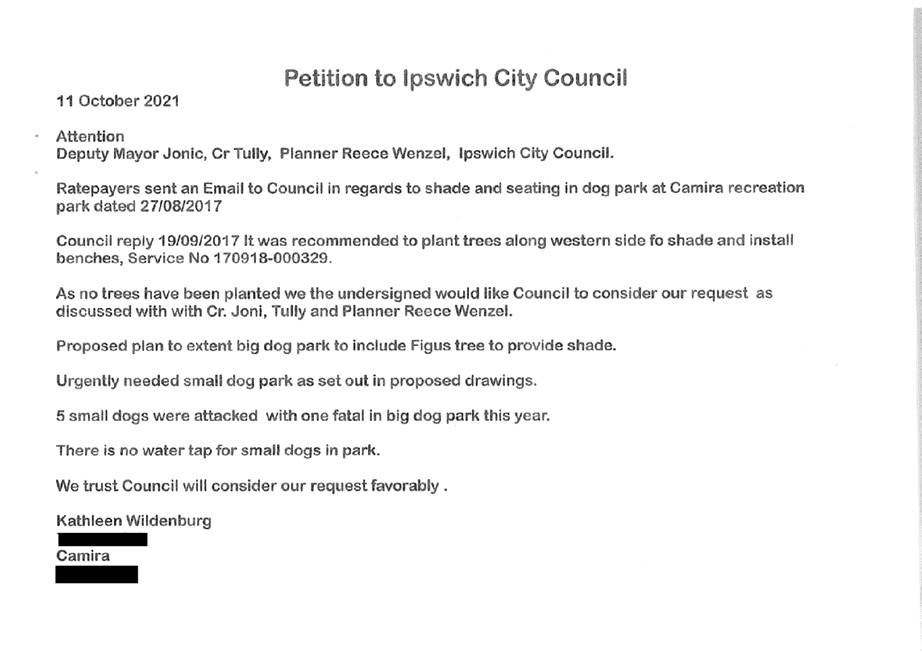
At the Council Ordinary Meeting on 9 December 2021, a petition from the local community was presented to Council requesting additional embellishments to the existing leash free dog area (LFDA) at the Camira Recreation Park, Camira.
The Petition
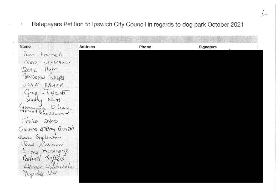
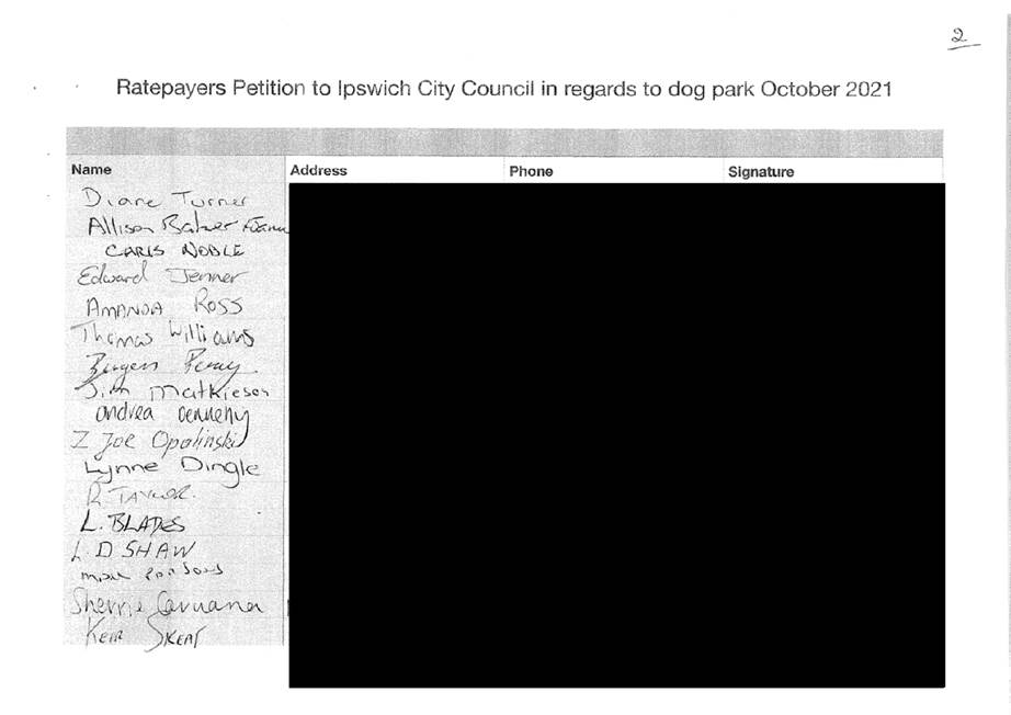
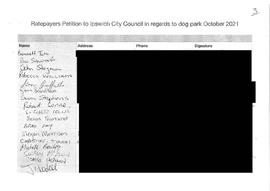
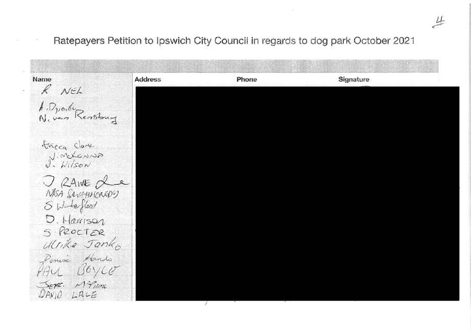
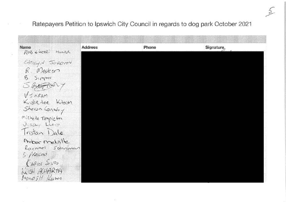
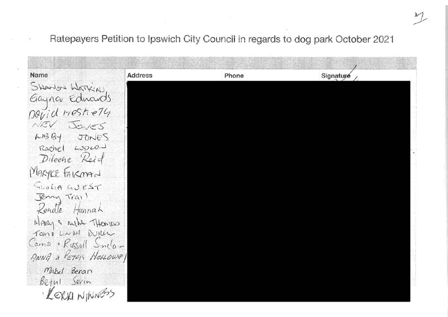
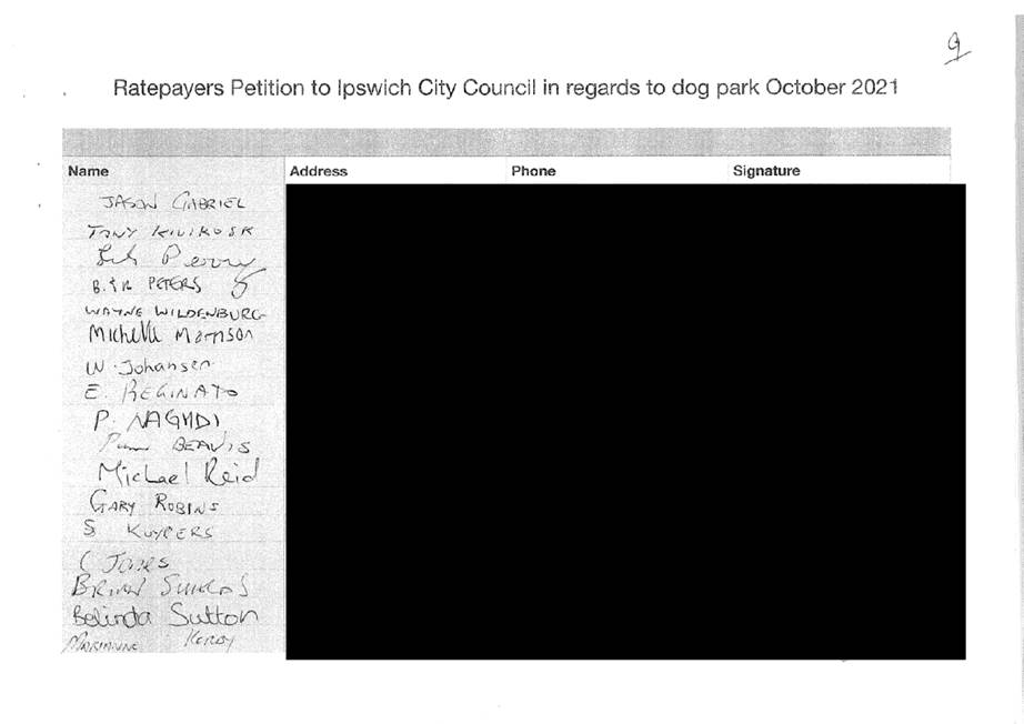
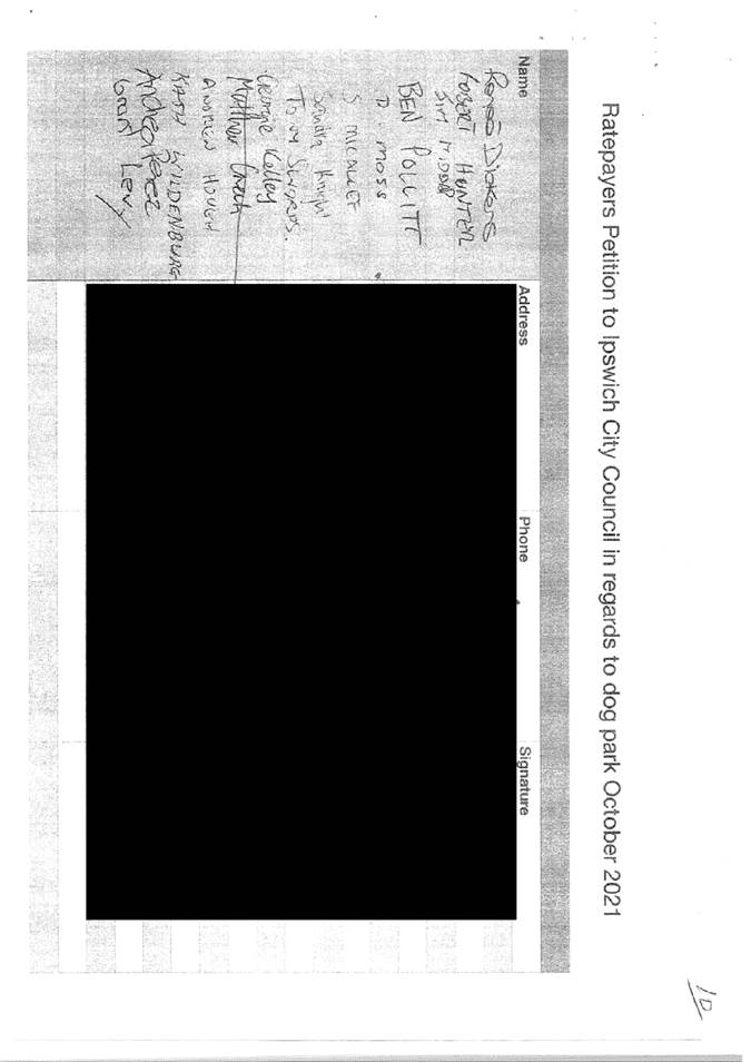
A copy of the petition presented to Council can be found in Attachment 1 of this report. The submitted petition has 168 signatures from individuals.
The petition has requested that Council consider a number of items within the LFDA in the Camira Recreation Reserve as noted below:
1. additional seating, shelters and shade trees to be planted;
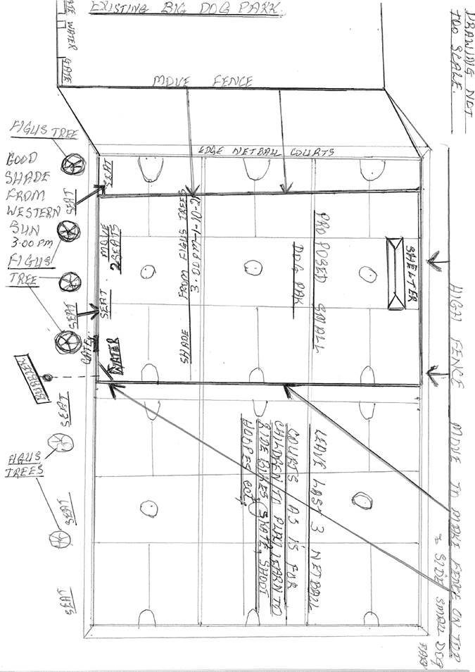
2. the expansion of the LFDA to support the separation of small and large breed dogs. The petition states there have been multiple incidences between dogs occurring at the existing LFDA, with an unfortunate incident resulting in the death of a small dog. The petition also includes a sketch for a suggested layout and embellishments for the expansion of the LFDA.
Current Leash Free Dog Area
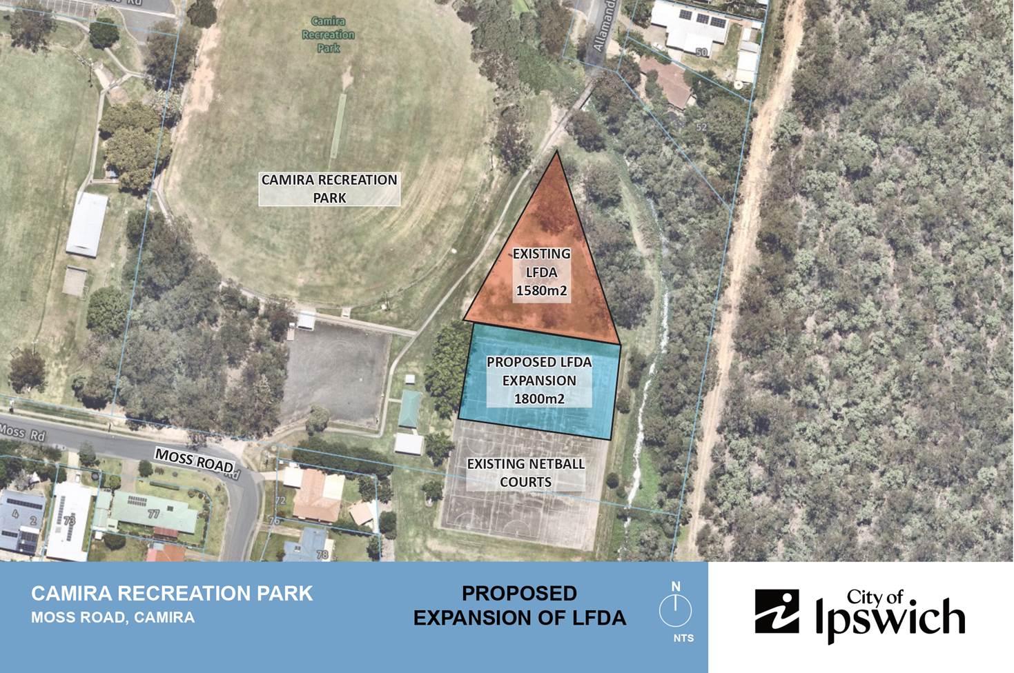
The current LFDA is located within the Camira Recreation Park at 70-98 Moss Road, Camira. The LFDA has been in place since the year 2000 and is bound by a fenced area of 1580m2.
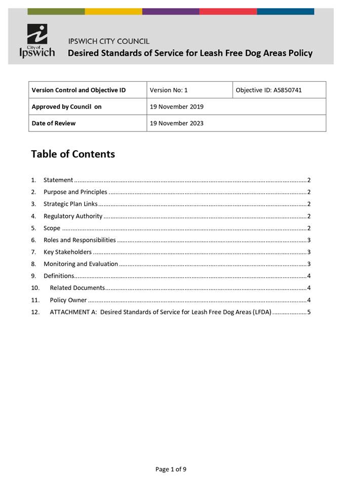
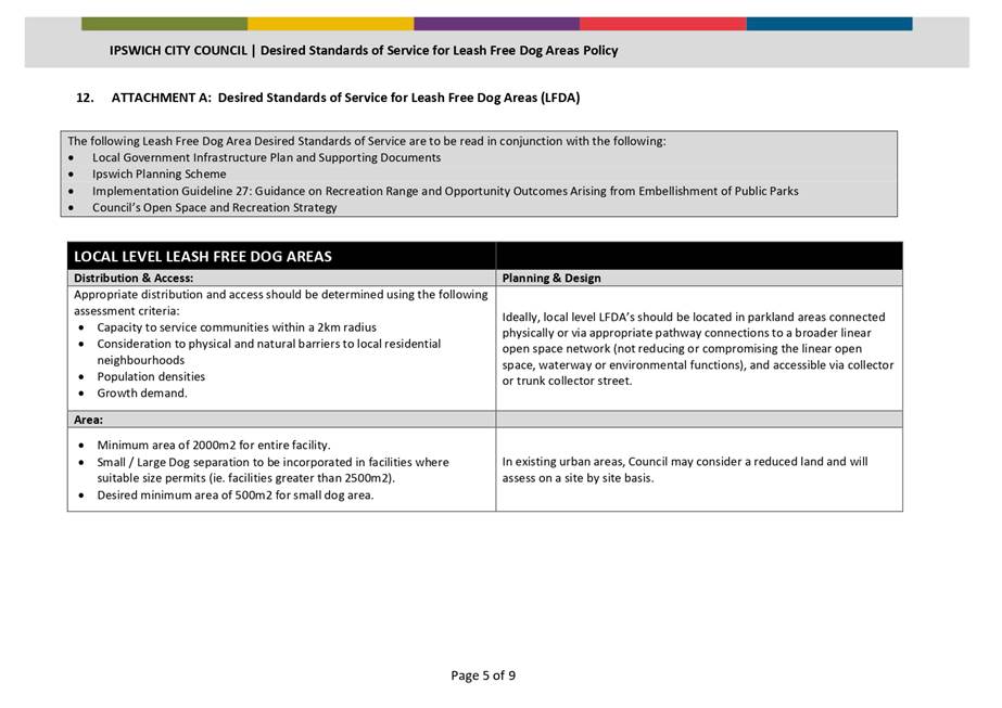
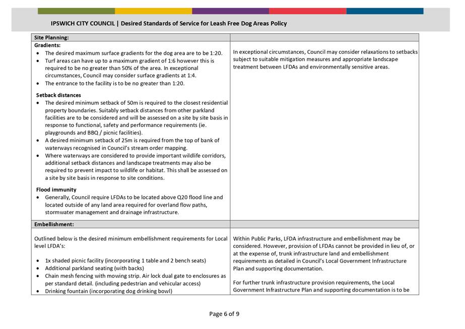
The existing site is classified as a ‘local’ level facility, in accordance with Council’s Desired Standards of Service for Leash Free Dog Areas Policy. A copy of the policy can be found in Attachment 2 of this report. Pages 5 – 7 of the policy lists Council’s desired standards of service for a local level LFDA.
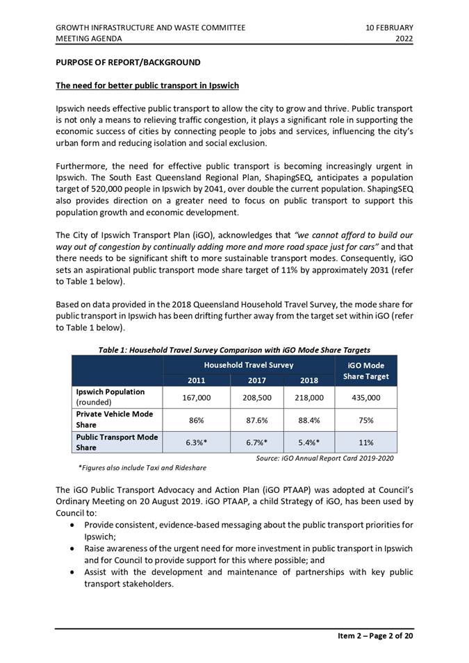
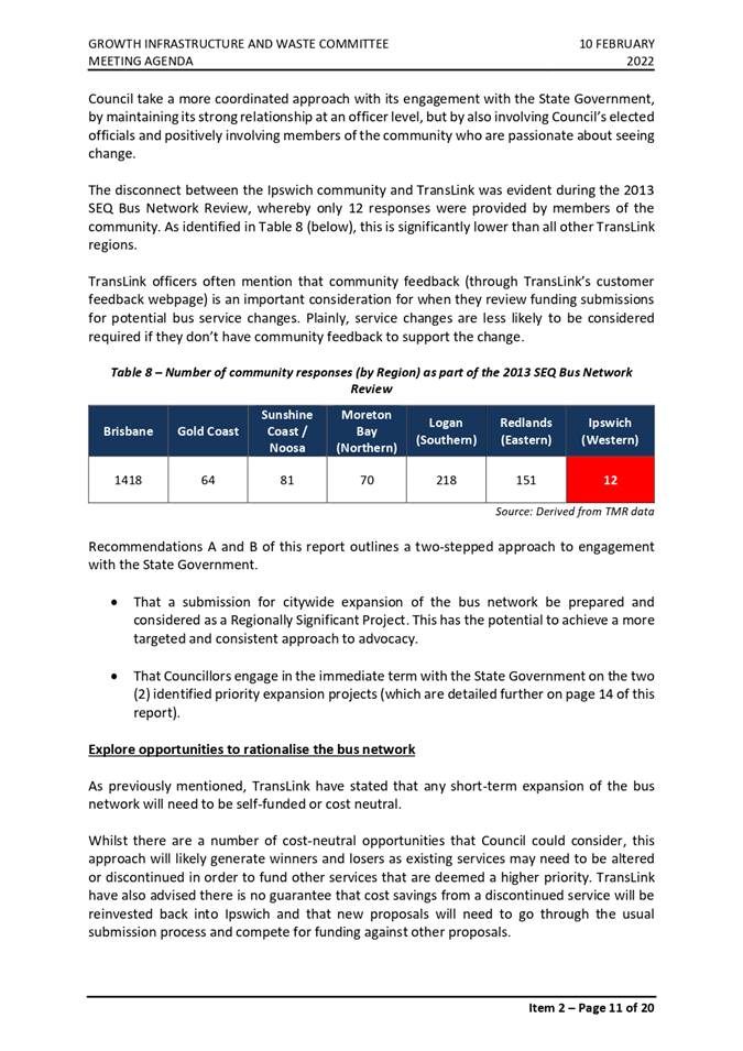
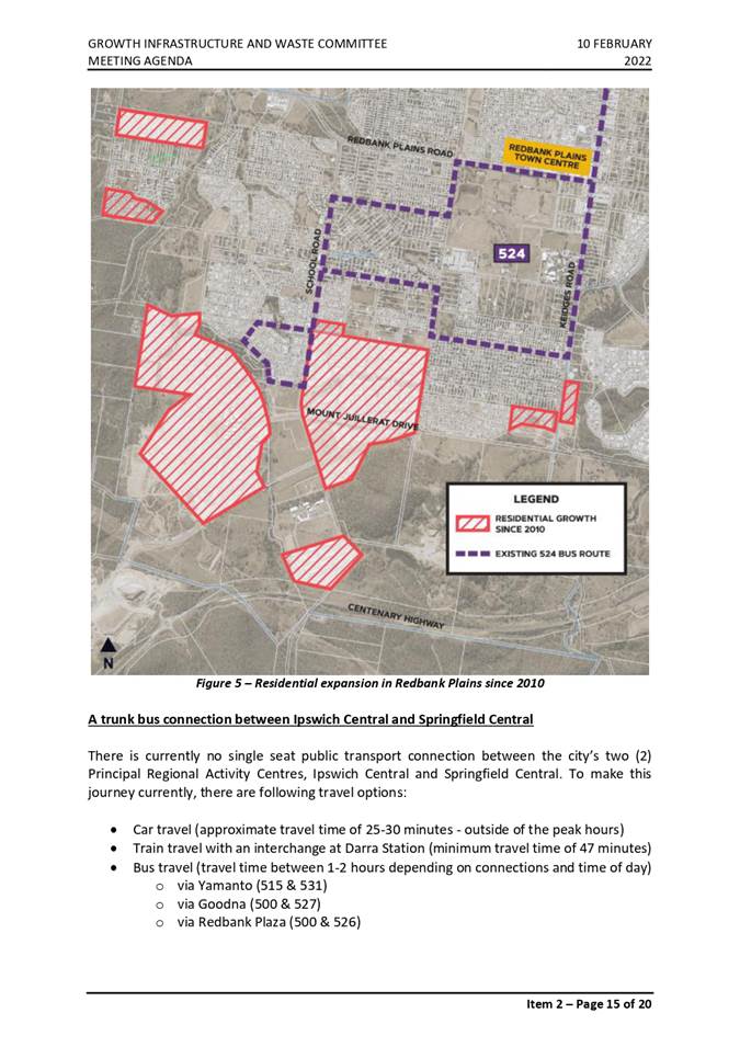
Figure 1 below provides an aerial view of the current location and identifies the area of the LFDA within the Camira Recreation Park.
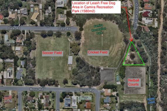
Figure 1. Camira Recreation Park (Nearmap Image November 2021).
The existing LFDA comprises the following infrastructure:
· Chain wire fence along the perimeter;
· Some mature trees;
· Drinking fountain;
· Waste bin;
· Tables and chairs with associated shelter.
Request Background
The chief petitioner has previously raised this matter with Council officers in August 2021. The advice provided in this report is consistent with the advice provided to the chief petitioner when the matter was initially raised.
Overall Assessment
Review of the existing LFDA facility located at Camira Recreation Park demonstrates the facility is 1580m2 in area. Council’s desired standards of service (DSS) for a local level LFDA specifies a minimum area of 2000m2 for the entire facility, therefore the current LFDA is smaller than the current DSS.
Separation of the existing LFDA for independent large and small breed dog areas is not recommended, as this would severely impact the functionality of the facility. Council’s DSS for a local level LFDA specifies small / large dog separation to be incorporated into facilities where suitable size permits (i.e. facilities should be greater than 2500m2).
Adjacent to the existing LFDA are 6 netball courts. The proposal by the Chief Petitioner is to expand the existing LFDA to the south over the existing netball courts to create a small dog breed facility. The proposal also suggests planting new trees for shade and provision of additional seating and shelters. A schematic of the proposal for the expansion of the LFDA onto the netball courts can be viewed in Attachment 3 of this report.
The existing netball courts currently accommodate recreational requirements and are not used for formalised community sport. The petition also suggests families/children that visit Camira Recreation Park utilise the hard surface as a ‘learn to ride’ or skate facility. This has been referenced in the sketch/design attached to the petition.
Officers have undertaken preliminary investigations to inform whether the land area currently accommodating the 6 netball courts would be appropriate for future expansion of the LFDA as proposed in the petition. The current netball courts would require partial demolition to accommodate suitably sized small and large LFDA’s.
Through investigations and engagement with Council’s Sport and Recreation team, it has been determined that although the current netball courts are primarily used for recreation purposes, there is still a current requirement to maintain these existing courts. Formalised sport was previously undertaken on these courts and have been redirected to the Springfield Central Sports Complex. However due to the surface subsidence and ongoing issues at the Springfield Central Sports Complex, retaining the current netball courts as an alternate facility for formalised sport is considered paramount. Once the issues at the Springfield Central Sports Complex are resolved, a re-evaluation of the utilisation of this area could be undertaken.
Although it is currently recommended to not expand the LFDA (and also recommended to retain the current netball courts at the Camira Recreation Park), any alternate use should be guided by an overall community sentiment for the park. The proposal expressed by the Chief Petitioner is one proposal for the overall use of this section of the park. Council officers propose to engage with the community to seek sentiment of any potential changes to the park should the netball courts be converted into an alternate use.
With regard to the request for additional trees within the park, Council officers have prioritised this as a project to be considered in a future Capital Works Program under the local parks and sports sub-program.
The request for additional seats and shelters are proposed by the chief petitioner within the expanded LFDA. If and when this is accommodated, these will be considered.
Assessment Conclusion
The request for the LFDA to facilitate both large and small breed dogs at the Camira Recreation Park is acknowledged. However, for the following reasons it is currently not supported:
· The current LFDA does not meet current DSS for ‘local’ level LFDA’s and cannot be segregated due to the substandard size;
· To expand the LFDA to the south to facilitate separate large and small dog breeds would require demolition of the existing netball courts;
· The current netball courts are required to be retained as an alternate formalised sporting facility due to the current issues at the Springfield Central Sports Complex;
· Demolishing the existing netball courts for an alternate use requires further community consultation. This community engagement will determine the future of the Camira Recreation Park in its entirety and its place within the planning of the greater Ipswich Sport and Recreation network.
Legal/Policy Basis
This report and its recommendations are consistent with the following legislative provisions:
Desired Standards of Service for Leash Free Dog Areas Policy
RISK MANAGEMENT IMPLICATIONS
If the leash free dog area is expanded as suggested in the petition, there is the risk that broader community needs have not been taken into consideration to support either community sport or local recreation demand.
By retaining the existing configuration of the leash free dog area there is a risk that there are additional conflicts between small and large breed dogs within this park.
HUMAN RIGHTS IMPLICATIONS
|
HUMAN RIGHTS IMPACTS |
|
|
OTHER DECISION https://objprd.council.ipswich.qld.gov.au/id:A7835642/document/versions/latest
|
|
|
(a) What is the Act/Decision being made? |
Recommendation A states That the leash free dog area within the Camira Recreation Park remain in its current configuration without further expansion. Recommendation B states That further planning be undertaken for the Camira Recreation Park, including community engagement, to seek sentiment of Sport and Recreation needs of the community. |
|
(b) What human rights are affected? |
No human rights are affected by this decision. By undertaking further planning on the proposed utilisation of the Camira Recreation Park, it will seek the overall needs of the community thereby ensuring human rights are considered in the overall facilities provided in the park. |
|
(c) How are the human rights limited? |
Not applicable
|
|
(d) Is there a good reason for limiting the relevant rights? Is the limitation fair and reasonable? |
Not Applicable
|
|
(e) Conclusion |
The decision is consistent with human rights. |
Financial/RESOURCE IMPLICATIONS
Given the recommendation that the current LFDA remains in its current configuration, then there is no financial or resource implications for Council.
Any installation of trees in the park will be considered as part of the Capital Works program and would be identified through the project prioritisation process.
Following consultation with the community, any proposed alterations to the Camira Recreation Park, and associated financial outcome, will be subject to further investigation.
COMMUNITY and OTHER CONSULTATION
Council officers have met with the chief petitioner prior to the formal petition being submitted to Council.
The Sport and Recreation team of Council have been consulted to determine the community requirements regarding the utilisation of the current netball courts at the Camira Recreation Park.
Conclusion
A petition requesting additional embellishment / expansion of the existing LFDA located at Camira Recreation Park was presented to Council at the Ordinary Meeting on 9 December 2021. Following investigations into the request, it is recommended that the current LFDA remain in its current configuration without expansion. Further investigation to determine the future of the Camira Recreation Reserve in its entirety and its place within the planning of the greater Ipswich open space network is required including community engagement for this park.
Attachments and Confidential Background Papers
|
1. |
Petition regarding leash free dog area, Camira Recreation
Park ⇩ |
|
2. |
Desired Standards of Service for Leash Free Dog Areas
Policy ⇩ |
|
3. |
Camira Recreation Reserve - Proposed expansion of leash
free dog area ⇩ |
Reece Wenzel
Planning Officer (Open Space)
I concur with the recommendations contained in this report.
Mary Torres
Infrastructure Strategy and Planning Manager
I concur with the recommendations contained in this report.
Tony Dileo
Manager, Infrastructure Strategy
I concur with the recommendations contained in this report.
Sean Madigan
General Manager - Infrastructure and Environment
“Together, we proudly enhance the quality of life for our community”
|
Growth Infrastructure and Waste Committee Meeting Agenda |
15 September 2022 |
ITEM: 2
SUBJECT: Redbank Plains Library Additional Community Meeting Space - Response to Notice of Motion
AUTHOR: Manager, Capital Program Delivery
DATE: 6 September 2022
This is a report providing a response to a Notice of Motion moved by Deputy Mayor Jacob Madsen at the Council Meeting of 19 May 2022:
That a design be prepared and costed for conversion of the former Mobile Library Garaged at Redbank Plains Library with said design to focus on delivery of:
a) Community Meeting space with afterhours access
b) External landscaping to allow appropriate pathways to afterhours access and use by community on special occasions
That the report Redbank Plains Library Additional Community Meeting Space – Response to Notice of Motion be received and the contents noted.
RELATED PARTIES
There are no discernible conflicts of interest arising as a result of this report and its recommendation.
ifuture Theme
Vibrant and Growing
Purpose of Report/Background
Council has asked that a design be prepared and costed for the conversion of the former Mobile Library Garage at Redbank Plains Library into additional community meeting space.
The former garage was inspected and a further two (2) potential locations adjacent to the library were also reviewed, with alternative room sizes explored.
In all, this provided six (6) options to explore to facilitate development of a community meeting space, with each having identifiable benefits and costs with a variety of budget requirements.
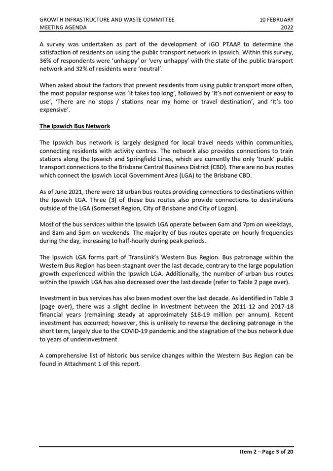
Figure 1 below illustrates the location of the options available for developing a Community Room in or adjacent to the Redbank Plains Library on Moreton Avenue.
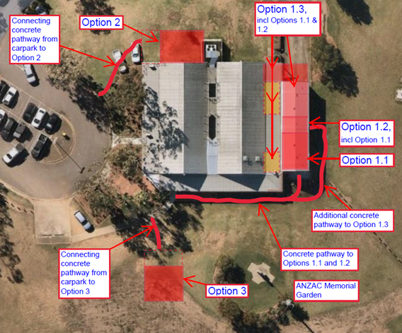
Figure 1 – Community Room Options
Location 1 – Re-fit of the Former Mobile Library Space
Noting the ground slab in the garage space is the original driveway slab and as such is deemed non-structural for the purposes of construction a building structure, there are three (3) sub-options for a solution constructed in this area:
Construct a room (4.6m x 7.2m) with tea making, wash-up facilities and space for approximately 20-30 persons, refer Figure 2.
Estimated cost of works – $260,000 ex GST.
Additional scope will be required to extend beyond simply creating the room within the existing garage space, the further work required will include the following:
· bird proofing and vermin proofing of the existing garage roof structure
· re-construct the gutter between the garage and the library roof to make it watertight
· construct new footings and a floor structure inside the existing garage building, independent of the existing shed structure
· provision of a DDA compliant concrete pathway from the carpark to the new entry door accessing the community space
· security and good quality lighting required for the accessways
· modify the existing secure veranda to permit controlled after-hours access to the existing toilets and amenities
· introduce topping slab in garage space to ensure slab area is weatherproof
Benefits of this solution are:
· little operational impact to the library
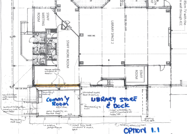
Figure 2 - Option 1.1 – 4.6m x 7.2m, 20–30-person room
Costs of this solution are:
· major disruption to the staff working environment through loss of key storage
· access to the community room is located at the ‘side’ of the existing library, increasing the security risk to user of the site after-hours
· requirement to provide additional permanent parking
· modifications required to the existing garage structure to develop windows and weatherproof access to the room
Option 1.2
Construct a room 4.6m x 11m with tea making, wash-up facilities and space for approximately 35-45 persons, refer Figure 3.
Estimated cost of works – $360,000, ex GST.
· all dot points from Option 1.1 outlined above
· the existing table lift needs to be relocated and a new access point to the staff work room will need to be constructed
· re-construction of the existing staff work room fire exit is required to provide a second egress path of travel and satisfy the requirements of the National Construction Code (NCC)
· introduce topping slab in garage space to ensure slab area is weatherproof
Benefits of this solution are:
· larger space for community meetings
Costs of this solution are:
· substantial disruption to staff working environment due to loss of storage
· requirement for substantial operational change at the library
· all costs associated with Option 1.1 apply to this option
Figure 3 – Option 1.2 – 4.6m x 11.0m, 35-45-person room
Option 1.3
Construct a room 4.6m x 19.3m with tea making, wash-up facilities and space for approximately 65-80 persons, refer Figure 4.
Estimated cost of works – $615,000ex GST.
Noting that while significant disruption to library operations will occur during this option’s construction activities, no allowance has been made for the associated costs.
Additional scope will be required to extend beyond simply creating the room within the existing garage space, the further work required will include the following:
· all dot points from Options 1.1 and 1.2 outlined above
· construct a new enclosed loading bay outside the garage roller door
· the existing table lift needs to be relocated and new access point to the staff work room constructed
· relocate the existing staff room
· remove existing rear fire exit from staff work room and expand slab area to enlarge the staff work room
Figure 4 - Option 1.3 - 4.6m x 19.3m, 65-80-person room
Benefits of this solution are:
· larger space for community meetings
· possible to create two (2) separate rooms operating concurrently
Costs of this solution are:
· all costs associated with Options 1.1 and 1.2 apply to this option
· significant disruption to staff working environment
· significant change required to library operations
· security and safety concerns are significantly increased as room access is to the ‘rear’ of the existing library, which is remote from the available parking spaces
· shape of the space is not good when used as one large space
Location 2 – Construction of a North-East Extension of the Library Space
If an extension was to be constructed on the north-east side of library space 1 it would need to be accessed independently of the library space but could be booked in a similar fashion to the two (2) existing northwest facing meeting rooms inside the library. This may create an operational impact on the library as the building area will have experience patronage and may require additional resourcing as a result.
Although patrons could access the existing amenities in a similar fashion to the other options, it is preferred that separate toilet facilities be provided to service the space. If the existing toilet access is deemed acceptable this additional cost could be saved.
There is sufficient vacant space around the proposed area for construction of the structure, however it is acknowledged that the ground surface falls away from the existing building and some filling will need to be introduced to develop a suitable building platform.
In this location the community space can be virtually any size necessary, but the following construction cost estimate was calculated based on creating a 7m x 10m space which would accommodate up to 50-70 persons in a sit-down lecture/training format, with foyer and self-contained PWD (persons with disabilities) toilet facilities and storage.
For Option 2.1 layout refer Figure 5 below.
Figure 5 - Option 2.1 - 7.0m x 10.0m, 50-70-person room
Estimated cost of works for Option 2.1 – $495,000, ex GST.
Option 2.2 is essentially the same meeting room layout as per Option 2.1 above, however it does not include a separate foyer, PWD amenities,storage and would be serviced by an open veranda form.
The estimated construction cost of these facilities in Option 2.1 is $59,800, reducing the estimated cost of works for Option 2.2 to $435,000 ex GST.
The scope of work will include the following:
· construction of a building platform to vacant space to the northeast
· construction of a new room maintaining the existing design intent of the library
· concrete pathway required from the carpark to the new community room veranda
· extend the existing security system to support use of the rooms
· service connections for the extension
Benefits of this solution are:
· construction can proceed with minimal disruption to library operations the existing library building aesthetic will not be compromised
· community rooms can be designed and sized to suit the perceived use
· provision of a moveable walls into library space 1 will allow larger outreach programs to be hosted by the library
· immediately adjacent to existing parking facilities
Disbenefits of this solution are:
· effectiveness of the eastern facing gable skylight in library space 1 will be reduced
· the hire of the room(s) may require a review of resources to manage it
· if no toilet or amenities are provided in the room, (ie Option 2.2) community room users will be required to travel outside the building to use the existing library public toilets and amenities
Location 3 – Construction of a Freestanding Community Meeting Room
This space would be accessed from outside and discreet from the library operations. The building aesthetic would be designed to complement the existing library forms and scale.
The space could be virtually any size envisaged, but the following costs were calculated based on creating a space which would accommodate 50-70 persons in a sit-down lecture/training format. The room would need to be approximately 8m x 9m in floor area, with tea making and wash-up facilities. The building could be designed with a northern facing veranda space to support ANZAC day activities and other events on or around the site.
Estimated cost of works – $415,000, ex GST.
The scope can provide toilets and amenities that are similar to those in Option 2, but it should be noted that the cost estimate does not include provision of these facilities.
Benefits of this solution are:
· construction can proceed without any disruption to library operations
· community rooms can be designed and sized to suit the perceived use
· immediately adjacent to existing parking facilities
Disbenefits of this solution are:
· hire of the room(s) may require a review of resources to manage
· security systems would be fully independent of the library installation
· if no toilet or amenities are provided in the room then community room users will be required to travel outside the building to use the existing library public toilets and amenities
Additional Information for Consideration
Car parking
Regardless of the option selected, the existing available carpark that services the library is limited to 14 cars, this includes two (2) DDA compliant spaces.
Library staff currently park their vehicles on the grassed area to the east of the library to keep the carpark clear for the public to access.
Observations of the space indicate that the carpark is regularly 90% occupied.
Given the library is a driving destination library (due to its relatively remote location from public transport), the increased patronage generated by the planned community meeting room will in turn necessitate the need for additional parking to support the enhanced use.
Refer Figure 6 below for an image of the car parking around the library on a Sunday.
Figure 6 - NearMap Image of Parking on a Sunday
Disability Discrimination Act (DDA) Compliance
Application of further considerations under the National Construction Code (NCC) may be required due to the scope of modifications to the existing structure. This may trigger a requirement to upgrade other elements of the existing building, including accessways, amenities and parking to satisfy the requirements of DDA.
After-hours Access to Toilets and Amenities
Modifications to the existing security system will need to be undertaken to ensure secure, after-hours access is maintained to the library perimeter at all times. These costs have been included in the estimate.
The modification would be as follows:
· options 1.1, 1.2, and 1.3 will all require adjustments to the existing side access gate. The screen will need to be replaced with a suitably designed gate, or door, with self-closing, self-locking capability
· option 2.1 will not require any modifications as the facility can be fully self-contained
· options 2.2 and 3 will require secured access to be provided, either through a solution similar to that required for Options 1.1, 1.2, and 1.3 or a secured door constructed as a combined project to provide an after-hours book return facility at the southwest end of the existing secured veranda
Staff and Resources
It has been raised by Libraries staff that the resources allocated to the Redbank Plains Library once the library is refurbished, and the capacity increased, will be insufficient to support management of the community rooms.
Due to the proximity of the community room/s to the library, it is expected that members of the public will naturally gravitate to the library staff to both hire the space and seek resolution of issues, should they arise, during use of the spaces and may require additional resources to manage the meeting room/s.
Any decision to construct a new space should also allocate additional operational resourcing to run the additional space.
Legal/Policy Basis
This report and its recommendations are consistent with the following legislative provisions:
Not Applicable
RISK MANAGEMENT IMPLICATIONS
There are no risk management implications associated with this report and its ‘receive and note’ recommendation.
Potential matters relating to car parking, DDA compliance, after-hours access and resourcing have been provided in the report for awareness and consideration.
HUMAN RIGHTS IMPLICATIONS
|
HUMAN RIGHTS IMPACTS |
|
RECEIVE AND NOTE REPORT |
|
Recommendation A states ‘That the report Redbank Plains Library Additional Community Meeting Space – Response to Notice of Motion be received and the contents noted’. The decision to receive and note the report does not limit human rights. Therefore, the decision is compatible with human rights.
|
Financial/RESOURCE IMPLICATIONS
There are no financial or resource implications associated with this report and its ‘receive and note’ recommendation.
Potential matters relating to car parking, DDA compliance, after-hours access and resourcing have been provided in the report for awareness and consideration.
COMMUNITY and OTHER CONSULTATION
Redbank Plains Library staff.
Samantha Chandler, Manager Libraries and Customer Services.
Conclusion
The following table summarises the information provided for each of the locations and the respective room size options at each location.
Note all estimate figures stated are based on high level, square metre (sqm) rates, as provided by Rawlinson Australian Construction Handbook 2022.
|
Option |
Description |
Size |
Occupancy (occupancy assumes no restrictions due to COVID-19) |
Indicative Estimate * ($, ex GST) |
Impact on Library Operations |
|
1.1 |
Re-fit of former mobile library garage |
1 room, 4.6mx7.2m |
20-30 persons |
$260,000 |
High |
|
1.2 |
Re-fit of former mobile library garage |
1 room, 4.6mx11.0m |
35-45 persons |
$360,000 |
Substantial |
|
1.3 |
Re-fit of former mobile library garage |
2 rooms, 4.6mx19.3m in total |
65-80 persons |
$615,000 |
Significant |
|
2.1 |
Building extension to library space 1 with northern veranda |
2 rooms, 7.0mx10.0m in total |
50-70 persons |
$495,000 |
Minor |
|
2.2 |
Building extension to library space 1 with northern veranda |
2 rooms, 7.0mx10.0m in total |
50-70 persons |
$435,000 |
Minor |
|
3 |
Free-standing building located to the west of the library entry door |
1-2 rooms, 8.0mx9.0m in total |
50-70 persons |
$415,000 |
Nil |
*Exclusions from estimate:
· cost of disruption to library operations and use
· council’s internal and external costs
· loose furnish and fittings
· digital technology or AV equipment
· upgrade of services to cater for additional building use
· special site considerations a listed below
In general, several other considerations must be assessed. These are universal to all options and are exacerbated by the anticipated increase of activity at the site, they include:
· a shortfall of formal parking spaces around the library
· safety and security around the site with an increase in after-hours access
· satisfaction of the requirement to provide Disability Discrimination Act 1992 (DDA) compliant access
· after-hours access to toilets and amenities
· operational resourcing to run the additional space
Graeme Martin
Manager, Capital Program Delivery
I concur with the recommendations contained in this report.
Sean Madigan
General Manager - Infrastructure and Environment
I concur with the recommendations contained in this report.
Ben Pole
General Manager, Community, Cultural and Economic Development
“Together, we proudly enhance the quality of life for our community”
|
Growth Infrastructure and Waste Committee Meeting Agenda |
15 September 2022 |
Growth Infrastructure and Waste Committee NO. 2022(07)
11 August 2022
Minutes
COUNCILLORS’ ATTENDANCE: Mayor Teresa Harding (Chairperson); Councillors Paul Tully (Deputy Chairperson), Sheila Ireland (via audio link), Deputy Mayor Jacob Madsen, Andrew Fechner, Kate Kunzelmann, Russell Milligan, Nicole Jonic and Marnie Doyle
COUNCILLOR’S APOLOGIES: Nil
OFFICERS’ ATTENDANCE: Chief Executive Officer (Sonia Cooper), General Manager Planning and Regulatory Services (Peter Tabulo), General Manager Infrastructure and Environment (Sean Madigan), General Manager Corporate Services (Matt Smith), General Manager Community, Cultural and Economic Development (Ben Pole), Chief Financial Officer (Jeff Keech), Manager Infrastructure Strategy (Tony Dileo), Senior Digital Media and Content Manager (Jodie Richter) Senior Policy and Communications Officer (David Shaw), Manager People and Culture (Talia Love-Linay), Works Manager (Cameron Hoger), Manager Compliance (Alisha Connaughton), Acting property Services Manager (Alicia Rieck), Senior Property Officer (Tenure) (Bianca Gaudry), Team Lead )Open Space and Facilities) (Mark Bastin), Principal Engineer (Traffic Operations) (Josh Ellis), Manager Capital Program Delivery (Graeme Martin) , Procurement Manager (Richard White) and Theatre Technician (Harrison Cate)
Councillor Doyle was not present at the commencement of the meeting.
|
Meeting Attendance via Audio Link Councillor Sheila Ireland requested attendance at the Growth, Infrastructure and Waste Committee of 11 August 2022 via audio link. This request was approved by Council at its meeting held on 28 July 2022. |
|
WELCOME TO COUNTRY/ACKNOWLEDGEMENT OF COUNTRY Mayor Teresa Harding (Chairperson) invited Councillor Kate Kunzelmann to deliver the Acknowledgement of Country.
|
|
DECLARATIONS OF INTEREST IN MATTERS ON THE AGENDA Nil
|
|
BUSINESS OUTSTANDING
|
|
1. Response to Petition - Leash Free Dog Area, Camira Recreation Park This is a report concerning a petition received from the local community requesting alterations to the existing leash free dog area located at Camira Recreation Park, Camira. |
|
DECISION Moved by Mayor Teresa Harding: Seconded by Councillor Nicole Jonic: A. That the leash free dog area within the Camira Recreation Park remain in its current configuration without further expansion. B. That further planning be undertaken for the Camira Recreation Park, including community engagement, to seek the sentiment of sport and recreation needs of the community. C. That the chief petitioner be advised of the outcome of this report.
|
|
DECISION Moved by Councillor Paul Tully: Seconded by Councillor Nicole Jonic: That
the matter lay on the table. |
|
AFFIRMATIVE NEGATIVE Councillors: Councillors: Harding Nil Tully Ireland Madsen Fechner Kunzelmann Milligan Jonic
The motion was put and carried.
|
2. Response to Petition - Opening of River Road, Bundamba to traffic at its intersection with Nelson Street This is a report concerning a petition received from the local community requesting that consideration be given to opening River Road, Bundamba to traffic at its intersection with Nelson Street. |
|
DECISION Moved by Mayor Teresa Harding: Seconded by Councillor Andrew Fechner: A. That River Road, Bundamba remain closed north of the intersection with Nelson Street. B. That the chief petitioner be advised of the outcome of this report.
|
|
AFFIRMATIVE NEGATIVE Councillors: Councillors: Harding Nil Tully Ireland Madsen Fechner Kunzelmann Milligan Jonic
The motion was put and carried.
|
|
3. Redbank Plains Library Additional Community Meeting Space - Response to Notice of Motion This is a report providing a response to a Notice of Motion moved by Deputy Mayor Jacob Madsen at the Council Meeting of 19 May 2022: That a design be prepared and costed for conversion of the former Mobile Library Garaged at Redbank Plains Library with said design to focus on delivery of: a) Community Meeting space with afterhours access b) External landscaping to allow appropriate pathways to afterhours access and use by community on special occasions. |
|
Recommendation That the report Redbank Plains Library Additional Community Meeting Space – Response to Notice of Motion be received and the contents noted.
|
|
DECISION Moved by Deputy Mayor Jacob Madsen: Seconded by Councillor Sheila Ireland: That
the matter lay on the table for one (1) month. |
|
AFFIRMATIVE NEGATIVE Councillors: Councillors: Harding Nil Tully Ireland Madsen Fechner Kunzelmann Milligan Jonic
The motion was put and carried.
|
4. Deebing Heights Heritage Centre Council will recall that in February 2021 at a workshop it considered the matter of a proposal by the then developers of the land to enter into a partnership that would explore and hopefully achieve a Heritage Centre being constructed on land at Grampian Drive Deebing Heights. As an outcome of the workshop the General Manager Planning and Regulatory Services was requested to seek input from Council’s Indigenous Liaison Officers as well as information on any similar centres/ museum that maybe operating and that a report be presented back to Council. This report is tabled for information purposes and to advise that the matter is on hold and further reporting will occur when new information is at hand. |
|
DECISION Moved by Mayor Teresa Harding: Seconded by Councillor Andrew Fechner: That the report be noted and that no further action is required on this matter at this time.
|
|
AFFIRMATIVE NEGATIVE Councillors: Councillors: Harding Nil Tully Ireland Madsen Fechner Kunzelmann Milligan Jonic
The motion was put and carried.
|
Confirmation of Minutes
|
5. Confirmation of Minutes of the Growth Infrastructure and Waste Committee No. 2022(06) of 14 July 2022 |
|
DECISION Moved by Mayor Teresa Harding: Seconded by Councillor Paul Tully: That the Minutes of the Meeting held on 14 July 2022 be confirmed.
|
|
AFFIRMATIVE NEGATIVE Councillors: Councillors: Harding Nil Tully Ireland Madsen Fechner Kunzelmann Milligan Jonic
The motion was out
|
Officers’ Reports
|
6. Ipswich General Cemetery Heritage Project Concept Design This is a report concerning the preferred concept design for the Ipswich General Cemetery Heritage Project. The project was initially commenced to relocate unsafe displaced headstones that were moved in the “clean up” of the cemetery in the late 1970’s. |
|
DECISION Moved by Mayor Teresa Harding: Seconded by Councillor Kate Kunzelmann: That the report be received and the contents noted.
|
|
Councillor Tully moved a variation to the motion by the incorporation of Recommendation B:
B. That council proceed with developing a final concept design and cost estimates for the Memorial Garden.
The mover and seconder agreed to the proposed variation. |
|
DECISION Moved by Mayor Teresa Harding: Seconded by Councillor Kate Kunzelmann: A. That the report be received and the contents noted.
B. That council proceed with developing a final concept
design and cost estimates for the Memorial Garden. |
|
AFFIRMATIVE NEGATIVE Councillors: Councillors: Harding Nil Tully Ireland Madsen Fechner Kunzelmann Milligan Jonic
The motion was put and carried.
|
|
7. Personal Tributes in Council's Open Space and Road Network - Assessment of Application This is a report concerning a ‘Personal Tribute in Council’s Open Space and Road Network’ application which has been received by Council from Mrs Carmel Kendrick in memory of her late husband Mr Murray Kendrick. |
|
DECISION Moved by Mayor Teresa Harding: Seconded by Councillor Kate Kunzelmann: That the personal tribute as noted in the application detailed in Attachment 1, be approved by Council.
|
|
AFFIRMATIVE NEGATIVE Councillors: Councillors: Harding Nil Tully Ireland Madsen Fechner Kunzelmann Milligan Jonic
The motion was put and carried.
|
|
8. 16829 Redbank Plains Road Stage 3 Upgrade This is a report concerning the recommendation to vary 16829 Civil Construction Works Redbank Plains Road – Stage 3 project with AllRoads Pty Ltd as per Attachment 1.
|
|
“The attachment/s to this report are confidential in accordance with section 254J(3)(g) of the Local Government Regulation 2012.” |
|
DECISION Moved by Mayor Teresa Harding: Seconded by Councillor Paul Tully: A. That
the contractual arrangement (Council contract 16829) with Allroads Pty Ltd
(Supplier) for Civil Construction Works Redbank Plains Road –
Stage 3 be varied as follows: (i) To resolve request variations as raised by AllRoads Pty Ltd in response to global and local events impacting contract costings. Refer to details as per confidential Attachment 1. (ii) To amend the purchase price as per the details in
confidential Attachment 1. B. That Council enter into a deed of variation with AllRoads Pty Ltd to appropriately amend the existing contractual arrangement. C. That pursuant to Section 257(1)(b) of the Local Government Act 2009, Council resolve to delegate to the Chief Executive Officer the power to take “contractual action” pursuant to section 238 of the Regulation, in order to implement Council’s decision.
|
|
AFFIRMATIVE NEGATIVE Councillors: Councillors: Harding Nil Tully Ireland Madsen Fechner Kunzelmann Milligan Jonic
The motion was put and carried.
|
|
9. Adoption of the Updated Construction and Repair of Property Access Policy This is a report concerning the adoption of the revised Construction and Repair of Property Access Policy which has been reviewed, updated and placed onto the new corporate template which is part of the regular policy and procedure review process. The objective of this policy is to provide guidance to council officers and property owners in regard to the construction, maintenance and management responsibilities of crossovers (driveways) for property access. As part of the update process, this policy did require a substantial change to align with current processes and practices within Council. |
|
DECISION Moved by Mayor Teresa Harding: Seconded by Councillor Paul Tully: That the revised policy titled ‘Construction and Repair of Property Access Policy’ as detailed in Attachment 5, be adopted.
|
|
AFFIRMATIVE NEGATIVE Councillors: Councillors: Harding Nil Tully Ireland Madsen Fechner Kunzelmann Milligan Jonic
The motion was put and carried.
|
|
10. Adoption of the Updated Graffiti Removal Policy This is a report concerning the adoption of the updated Graffiti Removal Policy that has been reviewed, updated and placed onto the new corporate template which is part of the regular policy and procedure review process. The objective of this policy is to continue to guide the development, management and maintenance of graffiti within our local government area. As part of the update process, this policy did require a minor change to align with current processes and practices within Council. This change will not impact the removal of graffiti within our community nor affect service level timeframes. |
|
DECISION Moved by Mayor Teresa Harding: Seconded by Councillor Andrew Fechner: That the revised policy titled ‘Graffiti Removal Policy’ as detailed in Attachment 3, be adopted.
|
|
AFFIRMATIVE NEGATIVE Councillors: Councillors: Harding Nil Tully Ireland Madsen Fechner Kunzelmann Milligan Jonic
The motion was put and carried.
|
|
11. Infrastructure and Environment Department Capital Delivery Report June 2022 This is a report concerning the
performance of the capital delivery by the Infrastructure and Environment
Department for the month of June 2022. |
|
DECISION Moved by Mayor Teresa Harding: Seconded by Councillor Andrew Fechner: That the report be received and the contents noted.
|
|
AFFIRMATIVE NEGATIVE Councillors: Councillors: Harding Nil Tully Ireland Madsen Fechner Kunzelmann Milligan Jonic
The motion was put and carried.
|
|
12. Exercise Of Delegation Report This is a report concerning applications that have been determined by delegated authority for the period 4 July 2022 to 26 July 2022. |
|
DECISION Moved by Mayor Teresa Harding: Seconded by Councillor Kate Kunzelmann: That the report be received and the contents noted.
|
|
AFFIRMATIVE NEGATIVE Councillors: Councillors: Harding Nil Tully Ireland Madsen Fechner Kunzelmann Milligan Jonic
The motion was put and carried.
|
Councillor Marnie Doyle arrived at the meeting at 9.45 am.
|
13. Planning and Environment Court Action Status Report This is a report concerning a status update with respect to current court actions associated with development planning applications |
|
DECISION Moved by Mayor Teresa Harding: Seconded by Councillor Andrew Fechner: That the report be received and the contents noted.
|
|
AFFIRMATIVE NEGATIVE Councillors: Councillors: Harding Nil Tully Ireland Madsen Doyle Fechner Kunzelmann Milligan Jonic
The motion was put and carried.
|
|
NOTICES OF
MOTION |
|
MATTERS ARISING
Nil
|
PROCEDURAL MOTIONS AND FORMAL MATTERS
The meeting commenced at 9.00 am.
The meeting closed at 9.47 am.
|
Growth Infrastructure and Waste Committee Meeting Agenda |
15 September 2022 |
ITEM: 4
SUBJECT: Development Application - 2295/2020/VA - Variation Application seeking preliminary approval to vary the Planning Scheme from Rural Constrained - Ripley Valley Zone and Future Urban Zone, at Siddans Road Deebing Heights
AUTHOR: Senior Planner (Development)
DATE: 19 August 2022
Executive Summary
This is a report concerning a development application (Variation Application) seeking a Preliminary Approval that includes a Variation Approval to vary the Planning Scheme from Rural Constrained-Ripley Valley Zone and Future Urban Zone to Sub-Urban (T3) Zone, over land located at 146 and 184 Siddans Road, Deebing Heights.
The application requires determination by Council owing to a request that was made by the applicant (through a registered lobbyist). More specifically, the applicant wrote to Council’s Chief Executive Officer (CEO) and requested that a determination be made that the scale, scope, nature and sensitivity of the application warrants a Council decision. Upon considering the applicant’s request, the CEO and General Manager - Planning and Regulatory Services agreed that the nature of the application warrants a Council decision in line with section 9 of the Ipswich City Council Framework for Development Applications and Related Activities Policy.
The proposed development has been assessed having regard to the applicable assessment benchmarks, matters prescribed by regulation and other relevant matters pursuant to s.45(5) of the Planning Act.
The proposed Variation Application seeking a Preliminary Approval that includes a Variation Approval to vary the Planning Scheme cannot be supported in accordance with section 5 and section 60 of the Planning Act 2016, as the proposal does not advance the purpose of the Planning Act 2016 and conflicts with the assessment benchmarks, matters prescribed by regulation and other relevant matters.
Recommendation/s
That Council refuse Development Application No. 2295/2020/CA, being a Variation Application - Preliminary Approval that includes a Variation Approval to vary the Planning Scheme from Rural Constrained-Ripley Valley Zone and Future Urban Zone to Sub-Urban (T3) Zone, for the reasons as contained in Attachment 2 of this report.
RELATED PARTIES
The related parties to this application are:
§ Landowner: Brian Francis Benson and Dorothy Jane Benson, and Daryll Bruce Stephens and Sandra Mary Stephens
§ Applicant: Axelom Capital No. 3 Pty Ltd C/ Baird & Hayes Surveyors and Planners
§ Planning Consultant: Baird & Hayes Surveyors and Planners
§ Lobbyist: PolicyWonks (Kirby Anderson)
§ Traffic Consultant: Bitzios Consulting
§ Bushfire: Brisbane Bushfire Consulting Pty Ltd
§ Civil Engineering: Hunt Michel and Partners Pty Ltd
§ Ecology: Al Mucci Enterprises, 280 S Environmental, and S5 Environmental (S5)
§ Stormwater: Water Technology Water, Coastal & Environmental Consultants
§ Residential Needs Assessment: Think Economics
§ Public Notification Consultant: Development Signs Australia Pty Ltd
ifuture Theme
Vibrant and Growing
Purpose of Report/Background
|
SITE ADDRESS: |
146 Siddans Road, DEEBING HEIGHTS QLD 4306 184 Siddans Road, DEEBING HEIGHTS QLD 4306 |
|
APPLICATION TYPE: |
Variation Request |
|
PROPOSAL: |
MCU – Variation Application - Preliminary Approval that includes a Variation Approval to vary the Planning Scheme from Rural Constrained-Ripley Valley Zone and Future Urban Zone to Sub-Urban (T3) Zone |
|
ZONE: |
Part Rural Constrained-Ripley Valley Zone (99.41%) and part Future Urban Zone (0.59%) |
|
OVERLAYS: |
§ OV1 Bushfire Risk Area § OV7A Building Height Restriction Area 15m § OV7A Transitional Surface § OV7B 8km Existing Committed Urban Townships Buffer § OV7C 20-25 ANEF Contour |
|
APPLICANT: |
Axelom Capital No. 3 Pty Ltd C/ Baird & Hayes |
|
OWNER: |
Brian Francis Benson and Dorothy Jane Benson, and Daryll Bruce Stephens and Sandra Mary Stephens |
|
EXISTING OR PROPOSED TRADING NAMES: |
Deebing Downs |
|
APPLICATION NO: |
2295/2020/VA |
|
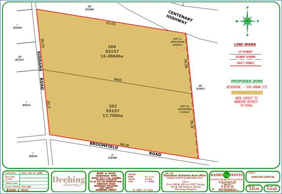
AREA: |
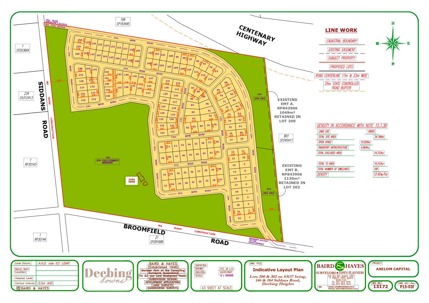
146 Siddans Road, Deebing Heights - 16.49ha 184 Siddans Road, Deebing Heights -17.70ha Total = 34.19ha |
|
REFERRAL AGENCIES: |
§ Department of State Development, Manufacturing, Infrastructure and Planning (SARA) - Concurrency agency § Department of Defence - Third Party Advice Agency |
|
EXISTING USE: |
146 Siddans Road, Deebing Heights – single residential dwelling 184 Siddans Road, Deebing Heights - single residential dwelling |
|
PREVIOUS RELATED APPROVALS: |
Not applicable |
|
DATE RECEIVED: |
25 March 2020 (properly made on 22 May 2020) |
|
DECISION PERIOD START DATE: |
12 January 2022 |
|
EXPECTED DETERMINATION DATE: |
23 September 2022 |
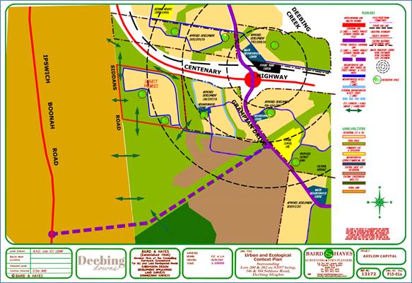
LOCALITY PLAN:
CURRENT PLANNING SCHEME ZONING MAP:
DRAFT PLANNING SCHEME ZONING MAP:
PROPOSAL PLANS:
Proposed Variation Scheme Area Plan
Proposed Context/Structure Plan
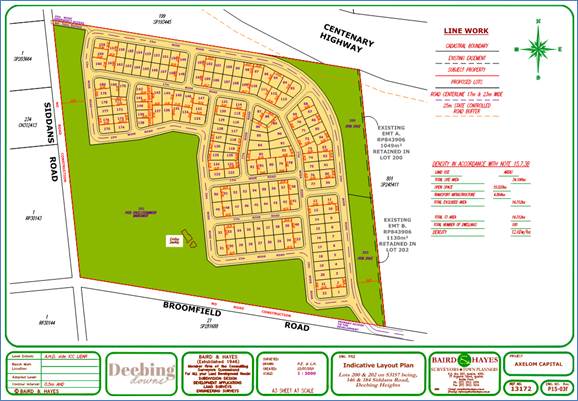
Indicative Subdivision Layout Plan
SITE DETAILS AND SURROUNDING LAND USES:
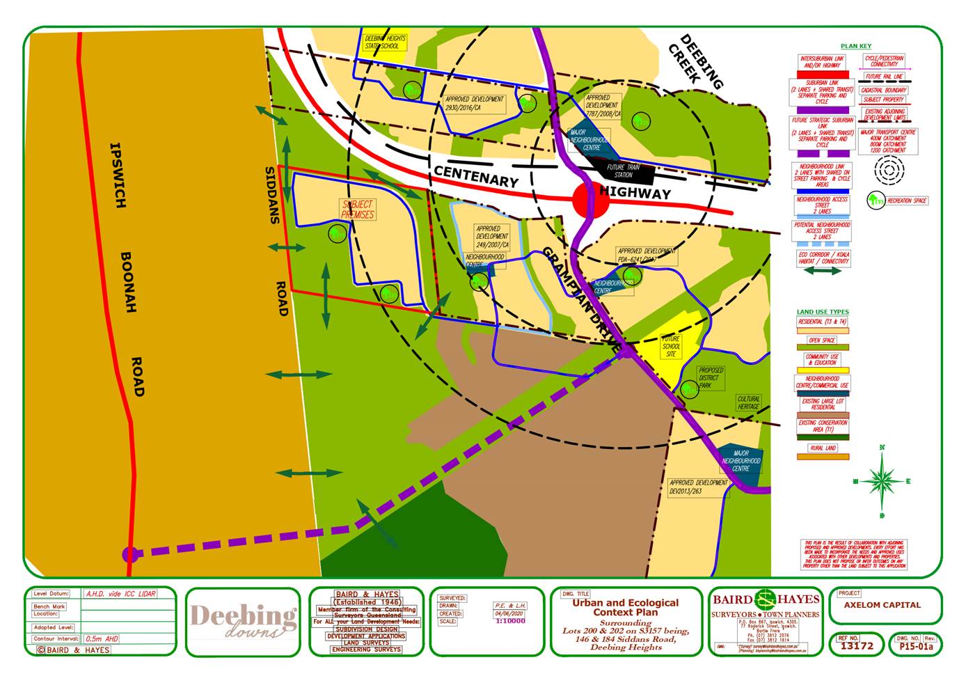
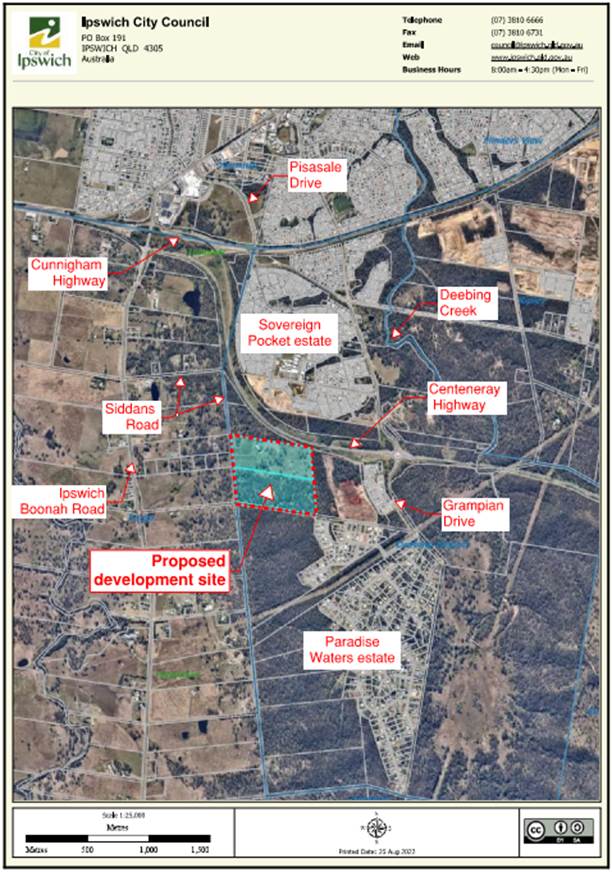
The subject site is located approximately 7.5km south of the Ipswich CBD and is at the intersection of Siddans Road and Broomfield Road which are both rural standard roads. The site consists of two (2) existing rural lots (146 and 184 Siddans Road), which together have a total area of 34.19ha. While part of the site adjoins the Centenary Highway and an unnamed road that extends off recently constructed Paradise Close, the site is physically accessible only via Ipswich Boonah Road and Siddans Road. The Locality Plan above includes some descriptions of the features to locate the site, along with the area of the proposal.
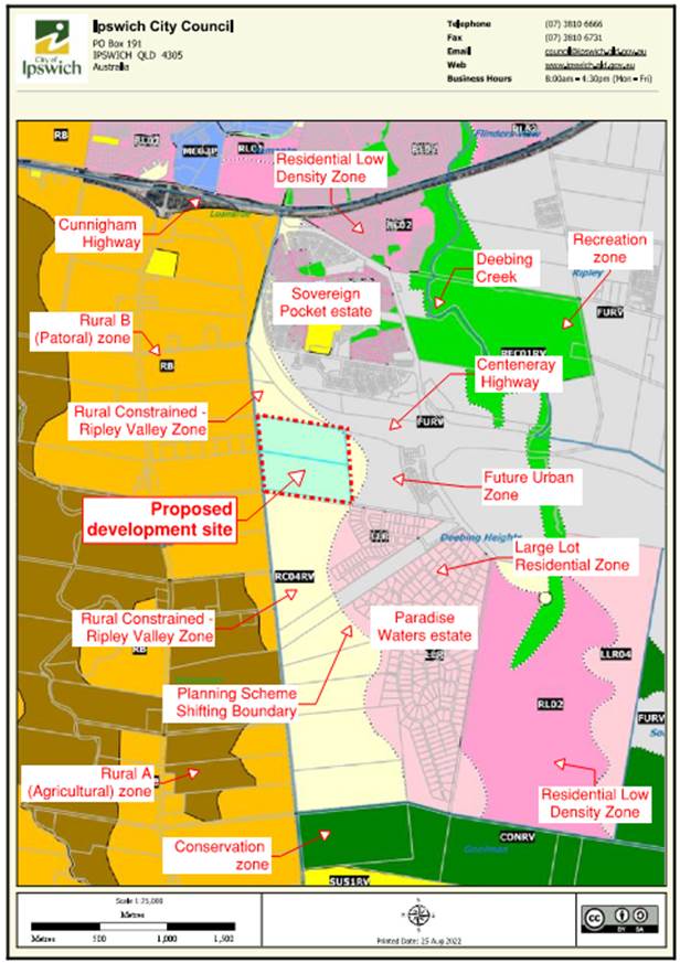
The site is predominately surrounded by landholdings that are in the Rural Constrained-Ripley Valley Zone and/or Rural B (Pastoral) Zone. Land to the east of the site and adjoining the Grampian Drive and Centenary Highway is predominantly in the Future Urban Zone with some of this land having already been or currently being developed for residential lots. The residential estates to the east that have been or are currently being developed are commonly known as Highgrove estate, Flourish, Botanica, Torhaven, Deebing Springs, and Paradise Waters.
Whilst there is some residential development occurring to the east, it is noted that these developments have been required to preserve a densely vegetated corridor all the way along their western edge (immediately adjoining the subject site) in order to maintain an ecological corridor that facilitates fauna movements and a treed visual ridgeline. It was envisaged that this vegetated corridor would extend further west from the edge of the new developments to Siddans Road in order to provide a vegetated transitional buffer to the rural zoned land to the west and the Conservation zoned land to the south.
The southern lot subject to this application (184 Siddans Road) is densely vegetated, contains 3 natural gullies and is currently located within the Rural Constrained-Ripley Valley Zone. The northern lot subject to this application (146 Siddans Road) is sparsely vegetated and contains 2 natural gullies. Whilst a shifting zone boundary exists over 146 Siddans Road it is noted that the majority of the site (99%) is currently located within the Rural Constrained-Ripley Valley Zone and the balance is located within the Future Urban Zone. Owing to both these sites being located within a highly vegetated area, they are identified as being within a bushfire risk overlay area pursuant to the Ipswich Planning Scheme.
PROPOSAL:
The development application (Variation Application) seeks a Preliminary Approval that includes a Variation Approval to vary the Planning Scheme zone from the current Rural Constrained-Ripley Valley Zone and Future Urban Zone, to Ripley Valley Sub-Urban (T3) Zone so as to allow for residential development with a dwelling density of 10 to 20 dwellings per hectare.
In support of the proposal, the applicant has submitted a context or structure plan that includes the subject site and its immediate surroundings. This plan attempts to illustrate potential future network connections relating to provision of necessary infrastructure (water, sewer and roads) and connections to open space and ecological corridors external to the site. As per the submitted context or structure plan, the development site is intended to be connected to necessary infrastructure via extension of water, sewer and road network from the east over 7001 Soho Drive, Deebing Heights, which is currently being developed pursuant to development approval 249/2007/CA.
The applicant has also submitted an indicative subdivision layout for 180 residential lots with lot sizes varying from 600m2 to 1,250m2 achieving a dwelling density of 12 dwellings/hectare, however, this application does not seek approval for the submitted subdivision layout. While the applicant has submitted a number of technical reports relating to traffic, stormwater, ecology assessment, vegetation management, bush fire management, civil services etc they are more high-level reports and do not contain sufficient detailed information relating to site specific constraints and do not demonstrate attainable design solutions to mitigate the adverse impacts from the proposed development. Hence there is no certainty that the proposed lot layout, lot numbers, sizes, services connections etc as illustrated on the submitted indicative subdivision layout are achievable.
PLANNING FRAMEWORK
2017 Regional Plan, (ShapingSEQ)
The development site is included within the Urban Footprint.
The Ipswich Planning Scheme 2006 (the 2006 Scheme)
Pursuant to the 2006 Scheme the development site is:
(a) partly (99.41%) within the Rural Constrained-Ripley Valley Zone (Part 15, division 6);
(b) partly (0.59%) within the Future Urban Zone (Part 4, division 8);
(c) Planning Scheme ‘shifting boundary’ bifurcates the Rural Constrained-Ripley Valley zone and the Future Urban zone; and
(d) subject to a number of overlays, in particular the Development Constraints Overlay;
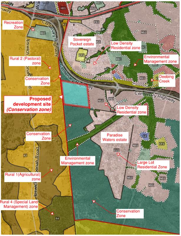
Draft Ipswich Planning Scheme 2019 (Statement of Proposals) (the draft scheme)
Pursuant to the terms of the draft scheme, the development site is nominated to be rezoned and located within a ‘Conservation’ zone.
COMMUNITY and OTHER CONSULTATION
Referral Agencies
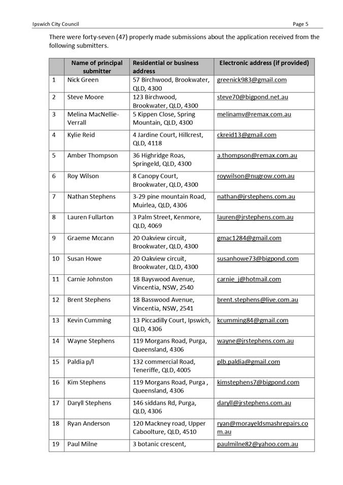
This development application required referral to a number of external agencies including the Queensland Government State Assessment Referral Agency (SARA) and Department of Defence (DOD). A summary of each of these referrals is as follows:
Queensland Government State Assessment Referral Agency (SARA)
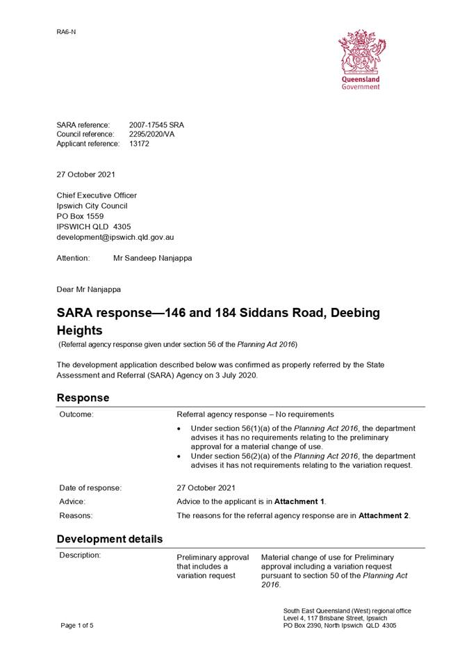
The application was referred to the Queensland Government State Assessment Referral Agency (SARA) as a concurrence agency as the site adjoins Centenary Highway which is State controlled road. SARA’s response dated 27 October 2021 advised that the SARA had no requirements relating to the variation request. In the Statement of Reasons (SOR) provided by SARA, Council was advised that:
§ the development complies with State code 1: Development in a state-controlled road environment of the SDAP. Specifically, the development:
- does not create safety hazard for users of a state-controlled road.
- does not compromise the structural integrity of state-controlled roads, road transport infrastructure or road works.
- does not result in a worsening of the physical condition or operating performance of state-controlled roads and the surrounding road network.
- does not compromise the state’s ability to construct, or significantly increase the cost to construct state-controlled roads and future state-controlled roads.
§ the development complies with State code 6: Protection of state transport networks of the SDAP. Specifically, the development:
- does not create safety hazard for users of a state transport infrastructure or public passenger services;
- does not result in a worsening of the physical condition or operating performance of the state transport network;
- does not compromise the state’s ability to cost-effectively construct, operate and maintain state transport infrastructure.
NOTE: The referral triggers did not require SARA to consider vegetation clearing as part of the subject referral process as this will only occur when the applicant submits a reconfiguration of a lot application over the site.
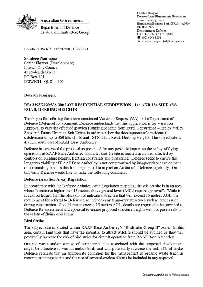
Department of Defence (DOD)
The application was referred to the Department of Defence (DOD) as a third-party advice agency. DOD’s response dated 29 May 2020 advised Council to have regard to Defence (Aviation Area) Regulations, bird strike management and extraneous lighting, relating to the proposed development.
INTERNAL CONSULTATION
The application and common material was presented to Council’s Initial Development Assessment Panel (consisting of various representatives from across the organisation) for review upon lodgement. At this meeting, it was determined that internal referral was required to the Engineering, Health and Environment Branch (EHE), City Design Branch and Infrastructure and Environment Department (Natural Environment) primarily owing to the below:
§ Proposed variation to Planning Scheme zone from Rural Constrained-Ripley Valley Zone and Future Urban Zone to Sub-Urban (T3) Zone.
§ Potential traffic impacts on surrounding road network.
§ Potential for stormwater and environmental impacts, and site-specific development constraints like bushfire risk, servicing capabilities etc.
The following assessment reports were prepared and have been incorporated into the recommendation:
- City Design Branch comments dated 29 May 2022
- Engineering report dated 29 November 2021 with reasons for refusal.
- Environment reports dated 25 February 2022 and 10 February 2022 with reasons for refusal.
Public Notification
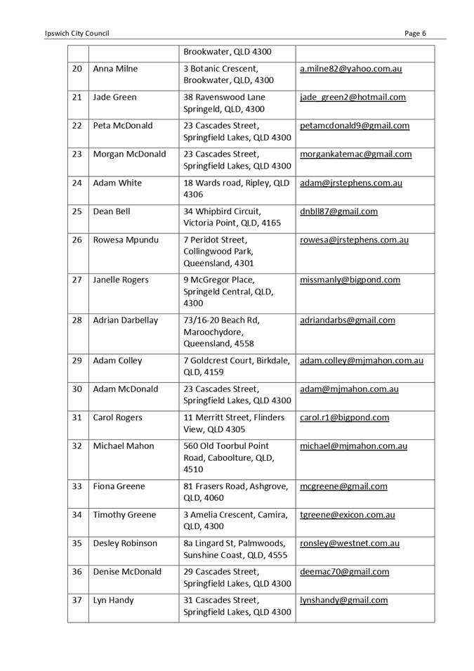
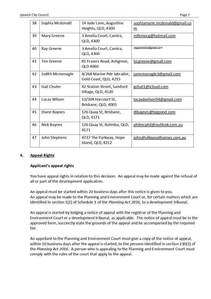
Public notification of this application was undertaken pursuant to the Planning Act 2016. The applicant undertook public notification from 4 November 2021 to 17 December 2021 for a period of 31 business days. During this period Council received forty-seven (47) properly made submissions and five (5) not properly made submissions, supporting the proposed development. Matters raised in the submissions include:
|
Matter raised |
How matters were dealt with in reaching a decision |
|
The proposed estate has my full support. The lot sizes, natural environmental setting and value for money is not offered in any estate nearby. |
The submissions received are common material for the application and have been considered as part of the application assessment. The application is recommended to be refused for the reasons outlined in ‘Reasons for Refusal’ below. |
Legal/Policy Basis
This report and its recommendations are consistent with the following legislative provisions:
Planning Act 2016
Planning Regulation 2017
RISK MANAGEMENT IMPLICATIONS
A risk to Council exists should the proposal not be determined in accordance with legislative requirements. The assessment and subsequent recommendations have been prepared to minimise the risk. Pursuant to DA Rules the due date to make a decision on this application is 23 September 2022 (extended due date with agreement by applicant) and the due date to issue the decision notice to the applicant is 30 September 2022. Upon issuing the decision notice the applicant and/or submitters may choose to appeal the Council’s decision in the Planning and Environment Court.
HUMAN RIGHTS IMPLICATIONS
|
HUMAN RIGHTS IMPACTS |
|
|
OTHER DECISION |
|
|
|
|
|
(a) What is the Act/Decision being made? |
Decision to refuse development application number 2295/2020/VA.
|
|
(b) What human rights are affected? |
The applicant is a company and therefore does not have human rights under the Human Rights Act 2019.
Forty-seven (47) properly made submissions and five (5) not properly made submissions were made in relation to the application, and therefore Council has an obligation to consider human rights in relation to the submitter. The submitters do have appeal rights pursuant to the Planning Act 2016.
The proposed decision does not have the potential to restrict or interfere with the right to privacy because before a person makes a submission regarding a development application they are provided advance notice (via Council’s website) that it is a requirement under the Planning Act 2016 that contact details of all properly made submitters be included on any decision notice and therefore they have the ability of consider whether to proceed with making a submission in spite of the legislatively required disclosure of their personal information.
In acknowledging a properly made submission, Council provides a letter to submitters advising them of this statutory requirement.
In the instance, the submitter’s personal information is already published on ePathway as the submitter did not advise Council that they did not want their personal information to be published (this opportunity is provided upon lodgement of submission), the submitter may request that the information be removed from ePathway and may also choose to withdraw their properly made submission should they not want their details to be included on the decision notice in accordance with statutory requirements. |
|
(c) How are the human rights limited? |
|
|
(d) Is there a good reason for limiting the relevant rights? Is the limitation fair and reasonable? |
|
|
(e) Conclusion |
The decision is consistent with human rights. |
Financial/RESOURCE IMPLICATIONS
There are no financial or resource implications associated with this report.
SUMMARY OF ASSESSMENT AND RECOMMENDATION
The proposed Variation Application seeking a Preliminary Approval to vary the Planning Scheme is recommended to be refused as the proposal does not advance the purpose of the Planning Act 2016, and as set out below the development conflicts with the assessment benchmarks, matters prescribed by regulation and other relevant matters in accordance with section 45(5)(a)(i), 45(5)(a)(ii) and 45(5)(b) respectively of the Planning Act 2016.
The key issues associated with the proposal which form the basis upon why this application is recommended to be refused can be summarised as follows:
Planning Rationale
The applicant has indicated that there is a level of ‘forward planning’ by the State Government owing to the fact that the subject development site in located within the Urban Footprint pursuant to ShapingSEQ - South East Queensland Regional Plan 2017. It should be noted that the Urban Footprint does not predetermine the appropriateness of land for urban development. This is a function of the local planning instrument (Ipswich Planning Scheme in this instance) as identified in Chapter 3 – Description of the Urban Footprint, Shaping SEQ August 2017 (page 101). Specifically, the Regional Plan relies on Local Government Planning Schemes to assess the extent and suitability of urban development.
As per Councils’ forward planning (including the Draft Ipswich Planning Scheme 2019), at this stage it is considered that the subject land is not suitable for urban development. The application proposes urban development over the subject development site which is contrary to Councils’ forward planning, and the development application has not adequately demonstrated that the site or the proposal:
(i) Is physically suitable for urban development.
(ii) Is either a logical expansion of an urban area or of sufficient size to provide social and economic infrastructure efficiently.
(iii) Has ready access to services and employment.
(iv) Maximises the use of committed and planned urban infrastructure.
(v) Is appropriately separated from incompatible land uses.
(vi) Maintain the integrity of inter-urban breaks and scenic amenity.
(vii) Excludes areas with an unacceptable risk from natural hazards, including predicted climate change impacts.
(viii) Excludes areas containing predominantly matters of national or state environmental significance and the regional biodiversity network, including koala habitat.
(ix) Achieves an appropriate balance of urban development in the SEQ region and across Ipswich City.
(x) Maintains a well-planned series of urban areas and compliments the neighbourhood structure planned for Ripley Valley.
(xi) Minimises impacts on natural resources.
(xii) Avoids irrevocable impacts to important, sensitive natural environments in and outside the area.
(xiii) Provides physical and social infrastructure efficiently, including public transport, and does not place additional demand on the established infrastructure charges regime.
(xiv) Addresses site specific constraints relating to topography, slope, scenic amenity, biodiversity, broad scale landscape and urban design, servicing and access.
(i) Assessment of the existing zone, zone intent and precinct.
(ii) The Ripley Valley Master Planned Area Structure Code including all six (6) supporting development themes.
(iii) The Traditional Neighbourhood Design Code.
Section 15.6.2 of Part 15 of Ipswich Planning Scheme identifies that uses and works within the Rural/Constrained (T2) Zone are to be located, designed and managed to be compatible with the amenity and character of surrounding lands; maintain townscape character and amenity; maintain the safety of people, buildings and works; and avoid significant adverse effects on the natural environment. The development application has not adequately demonstrated how the proposal is consistent with these requirements with specific regards to the subject site’s character owing to its location, environmental values and development constraints.
Planning Need
The current Ipswich Planning Scheme and Local Government Infrastructure Plan (LGIP) have
been planned to ultimate development capacity which demonstrably meets the City’s
anticipated population, employment and housing requirements beyond the 2041 lifespan of
the SEQ Regional Plan (refer to ICC Local Government Infrastructure Plan Supporting
Document – Planning Assumptions Summary Report, 2016). The submitted application
material has not adequately demonstrated the ‘Need’ for the proposed expansion to urban
development within the Ipswich LGA area, but rather focuses on providing a large lot/house size product in the general Ripley Valley area.
Furthermore, the application has not adequately demonstrated the deficiencies with the current land supply for low-density residential development that would warrant additional expansion of the serviced urban area, and how the proposed development will address these identified deficiencies in a manner that retains consistency with the existing local planning instrument.
Ecology
The submitted ecological documentation does not adequately justify the proposed development and does not provide certain, appropriate and attainable mitigation measures. Whilst the applicant has attempted to address some of the ecological impacts by means of an eco-corridor to allow the movement of fauna, and environmental offsets (compensatory planting) off-site, Council assessing officers are of the strong view that the applicant has not provided adequate technical reporting and/or justification to support the feasibility of the proposed eco-corridor, or demonstrated the statutory mechanism to achieve environmental offsets off-site over land not part of subject development application. This issue has been further discussed below:
§ As identified in the submitted ecology reports (prepared by S5 Environmental Consulting and Terrestria) a fauna survey of the site has been carried out and the reports identify the ecological significance of the development site (specifically over the southern lot being 184 Siddans Road). Contrary to the findings of the submitted ecology reports, the application proposes 50% of the southern lot to be cleared and a new road dissecting the contiguous corridor. Loss of koala habitat and vehicle strike via introduction of a road are contrary to koala survival.
§ The application proposes an underpass for koala movements. The submitted ecology documentation is preliminary at best and unsubstantiated that the proposed underpass can be accommodated within the area proposed. The proposed underpass length is in excess of 25m which is not considered to be a viable solution.
§ The submitted ecology reports assume that the adjoining eastern lot (7001 Soho Drive, Deebing Heights, which is currently being developed pursuant to development approval 249/2007/CA) will be fully developed which is incorrect as this approval requires approximately 100m of highly vegetated land on the western side of the lot to be retained as an ecological corridor. This corridor is a critical fauna movement passage to the south linking through Conservation Zoned land. The development application proposes to severe this corridor via the introduction of a new road.
§ The proposed bushfire management solutions rely on vegetation clearing on adjoining land that is zoned Rural Constrained – Ripley Valley. This solution is unsubstantiated and also impacts on the fauna movement passage mentioned above. Further, the proposed trunk sewer connection to the east is not within Urban Utilities (UU) network planning, is unsubstantiated and also has potential impacts on the fauna movement passage mentioned above.
§ The application proposes environmental offsets via compensatory planting off-site to address the residual impact of the proposal which will cause loss of 6.29 hectares of high value regrowth vegetation. This high value regrowth vegetation is likely to provide habitat for conservation significant species such as koala and grey-headed flying fox; and land mapped as Core Koala Habitat Area within a Koala Broad-Hectare designation. It should be noted that the Ipswich Planning Scheme has not included Matters of Local Environmental Significance (MLES) and therefore cannot enforce environmental offsets. While the Ipswich Planning Scheme Implementation Guideline No.19 does encourage environmental offsets, the Implementation Guideline has no statutory power as it is an implementation guideline and does not meet the test of an ‘offset’ as per the Environmental Offset Act. Nonetheless, under the principles of offset, the aim is to ‘avoid, mitigate and then offset’, and hence the expectation is to avoid vegetation clearing where possible which given the ‘Rural Constrained’ zone is certainly achievable on this site.
The applicant recently submitted a further ecology advice letter (prepared by Al Mucci Enterprises) however, this advice letter merely provides a peer review of the ecology reports that had already been submitted to date and does not undertake any further studies or provide any new technical reporting and/or justification for the proposal from an ecology perspective. The further ecology advice letter therefore does not overcome the issues identified above.
Purpose of the Planning Act 2016
(a) The proposal takes into account short and long-term environmental effects at local,
regional, State and wider levels; and
(b) The proposal applies the precautionary principle in taking measures to prevent degradation of the environment; and
(c) The proposal provides equity between present and future generations; and
(d) The proposal supplies infrastructure in a coordinated, efficient and orderly way; and
(e) The proposal applies amenity, conservation, energy use, health and safety in the built environment in ways that are cost-effective and of public benefit.
Assessment Benchmarks
|
Categorising Instrument |
Assessment Benchmarks |
|
Planning Regulation 2017, Schedule 10 |
Part 3, division 3 – Clearing native vegetation Part 10, division 2 – Koala habitat area |
|
State Planning Policy July 2017, Part E |
Planning for liveable communities and housing Planning for economic growth Planning for environment and heritage Planning for safety and resilience to hazards Planning for infrastructure |
|
Ipswich Planning Scheme 2006 |
Desired Environmental Outcomes and Performance Indicators (Part 3) Urban Areas Code (Part 4) Ripley Valley Master Planned Area Structure Plan Area Code (Part 15) Development Constraints Overlays Code (Part 11, division 4) Vegetation Management Code (Part 12, division 4) |
Relevant Matters
The assessment must give regard to the relevant matters identified in section 31 of the Planning Regulation 2017 and in accordance with section 45(5)(a)(ii) of the Planning Act 2016. The assessment had regard to the following matters:
|
Relevant matter |
Given regard to |
|
Planning Regulation 2017, Schedule 10 |
Part 3, division 3 – Clearing native vegetation Part 10, division 2 – Koala habitat area |
|
Planning Regulation 2017, s31(1)(d) |
(i) the regional plan for a region, to the extent the regional plan is not identified in the planning scheme as being appropriately integrated in the planning scheme; and (ii) the State Planning Policy, to the extent the State Planning Policy is not identified in the planning scheme as being appropriately integrated in the planning scheme. |
|
Planning Regulation 2017, s31(1)(f) |
any development approval for, and any lawful use of, the premises or adjacent premises; and |
|
Planning Regulation 2017, s31(1)(g) |
the common material. |
Other Relevant Matters
The assessment was also carried out having regard to other relevant matters in accordance
with section 45(5)(b) of the Planning Act 2016. The assessment had regard to the following matters:
|
Relevant matter |
Assessed against or had regard to |
|
Draft Ipswich Planning Scheme |
Regard was given to the Draft Ipswich Planning Scheme as a relevant matter to the application.
The draft scheme has undergone community consultation on the Statement of Proposal, including the draft Strategic Framework.
As per Councils’ forward planning (including the Draft Ipswich Planning Scheme 2019), Council at this stage does not consider the subject land as being suitable for urban development. The application proposes urban development over the subject development site which is contrary to Councils’ forward planning. |
|
ShapingSEQ - South East Queensland Regional Plan 2017 |
Regard was given to the ShapingSEQ - South East Queensland Regional Plan 2017 as a relevant matter.
Whilst the site is located within the Urban Footprint of ShapingSEQ - South East Queensland Regional Plan 2017, the subject land is not considered as ‘underutilised’. Underutilised within the context of ShapingSEQ refers to land that has remained underutilised for a substantial period of time and that has not transitioned from an investigation or emerging community zone to a serviced urban zone. The subject land has not been considered by the Ipswich Planning Scheme as being suitable for urban development and has not been included in any ‘transitional’ or forward planning zone. The development application has not adequately demonstrated the value of the site as an underutilised parcel and how the subject proposal contributes to the achievement of efficient delivery of housing choice and resolving land fragmentation and constraints that are a barrier to the delivery of urban development on the site.
The current Ipswich Planning Scheme and Local Government Infrastructure Plan (LGIP) have been planned to ultimate development capacity which demonstrably meets the City’s anticipated population, employment and housing requirements beyond the 2041 lifespan of the SEQ Regional Plan (refer to ICC Local Government Infrastructure Plan Supporting Document – Planning Assumptions Summary Report, 2016). The submitted application material has not demonstrated the ‘Need’ for the proposed expansion to urban development. Specifically, the development application has not adequately demonstrated the deficiencies with the current land supply for low-density residential development that would warrant additional expansion of the serviced urban area, and how the proposed development will address these identified deficiencies in a manner that retains consistency with the existing local planning instruments. |
|
The Queensland Government’s Koala Conservation Planning Framework commenced on 7 February 2020 and introduced new mapping that identified koala habitat areas as well as areas that are suitable for habitat restoration. This planning framework implements new clearing restrictions, prohibiting clearing of koala habitat areas within koala priority areas.
The development site was not mapped as a ‘koala habitat area’ at the date of lodgement of the development application, however, the entire development site is now mapped within a ‘Koala Habitat Restoration Area’. Further, the southern lot (184 Siddans Road) is now mapped as being located within a ‘Koala Habitat Area’.
In light of such, it is envisaged that the ‘Koala Habitat Restoration Areas’ could be replanted in the future to make them more suitable for koalas. The application proposes 50% of the southern lot (184 Siddans Road) to be cleared and a new road dissecting the contiguous ecological corridor. The loss of koala habitat and vehicle strike via introduction of a road are contrary to koala survival and hence the proposal is inconsistent with the intent of the Koala Conservation Planning Framework. |
Conclusion
An assessment of the proposal as described above has been undertaken and it has been determined that the proposal the assessment benchmarks, matters prescribed by regulation and other relevant matters ‘
Attachments and Confidential Background Papers
|
1. |
2295/2020/VA Proposal Plans ⇩ |
|
2. |
2295/2020/VA Draft Decision Notice (includes Reasons for
Refusal) ⇩ |
|
3. |
2295/2020/VA Draft Statement of Reasons ⇩ |
|
4. |
2295/2020/VA Referral Agency Response (Queensland
Government - SARA) ⇩ |
|
5. |
2295/2020/VA Third Party (Department of Defence) Advice ⇩ |
|
6. |
2295/2020/VA CEO consent for development application to be
determined by Full Council ⇩ |
Sandeep Nanjappa
Senior Planner (Development)
I concur with the recommendations contained in this report.
Michael Simmons
Development Assessment West Manager
I concur with the recommendations contained in this report.
Anthony Bowles
Manager, Development Planning
I concur with the recommendations contained in this report.
Peter Tabulo
General Manager Planning and Regulatory Services
“Together, we proudly enhance the quality of life for our community”
|
Growth Infrastructure and Waste Committee Meeting Agenda |
15 September 2022 |
Doc ID No: A8236657
ITEM: 5
SUBJECT: Development Application Recommendation - Temporary Accommodation (Camping Ground and Caravan Park) at One Mile
AUTHOR: Senior Planner (Development)
DATE: 25 August 2022
This is a report concerning an application seeking approval for a Material Change of Use – Temporary Accommodation (Camping Ground and Caravan Park – 46 sites) at 84 Chubb Street, One Mile.
The subject application requires review and determination by the Growth, Infrastructure and Waste Committee in accordance with the Framework for Development Applications and Related Activities Policy as more than 20 properly made submissions objecting to the proposed development were received.
The proposed development has been assessed with regard to the applicable assessment benchmarks and it was determined that it cannot be supported in accordance with section 5 and section 60 of the Planning Act 2016, as the proposal does not advance the purpose of the Planning Act, conflicts with the applicable codes of the Ipswich Planning Scheme and the other relevant matters applicable to the application.
That Council refuse Development Application No. 19904/2021/MCU for the reasons as contained in Attachment 2 of this report.
RELATED PARTIES
The related parties to this application are:
§ Landowner: Cheep Stays Pty Ltd
§ Applicant: Cheep Stays Pty Ltd C/- Reel Planning
§ Planning Consultant: Reel Planning
§ Town Planning Report: Reel Planning
§ Proposal Plans: Reel Planning
§ Flood Risk Management Plan: BMT
§ Stormwater Quantity Management Plan: BMT
§ Traffic Engineering Assessment: PTT Traffic and Transport Engineering
ifuture Theme
Vibrant and Growing
Purpose of Report/Background
|
SITE ADDRESS: |
84 Chubb Street, ONE MILE QLD 4305 |
|
APPLICATION TYPE: |
Material Change of Use |
|
PROPOSAL: |
Temporary Accommodation (Camping Ground and Caravan Park - 46 sites) |
|
ZONE: |
Part Recreation – 48% Part Large Lot Residential – 52% |
|
OVERLAYS: |
§ OV5 – 1:20 Development Line § OV5 – Adopted Flood Regulation Line; § OV7A – Building Height Restriction Area 15m § OV7A – Building Height Restriction Area 45m § Inner Horizontal Surface RL 71.5 § 3km Existing Committed Urban Townships Buffer |
|
APPLICANT: |
Cheep Stays Pty Ltd C/- Reel Planning |
|
OWNER: |
Cheep Stays Pty Ltd |
|
PROPOSED TRADING NAMES: |
None provided. |
|
APPLICATION NO: |
19904/2021/MCU |
|
AREA: |
6.664ha |
|
REFERRAL AGENCIES: |
Energex |
|
EXISTING USE: |
Former Gym/Squash Court |
|
PREVIOUS RELATED APPROVALS: |
437/2005/CA – Material Change of Use – Multiple Residential - 118 Aged Accommodation Units and ancillary Recreation Facilities
437/2005/MA/A – Extension to Relevant Period (Approved 18 March 2011, Extended to 19 March 2012)
437/2005/MA/B – Extension to Relevant Period (Refused 25 May 2012)
323/2010/RAL – Reconfiguring a Lot – One (1) lot into 42 lots (Community Management Scheme)
323/2010/MA/A – Extension to Relevant Period (Approved 16 March 2011, Extended to 19 March 2012)
323/2010/MA/B – Extension to Relevant Period (Refused 25 May 2012)
|
|
DATE RECEIVED: |
17 December 2021 |
|
DECISION PERIOD START DATE: |
22 July 2022 |
|
EXPECTED DETERMINATION DATE: |
22 September 2022 |
SITE LOCATION:
![]()
![]()
![]()
|
LEGEND
|
FLOOD MAPPING:
![]()
|
LEGEND
Subject Site
Proposed development extent
Adopted Flood Regulation Line
1:20 Development Line
|
PROPOSAL PLANS:
![]()
![]()
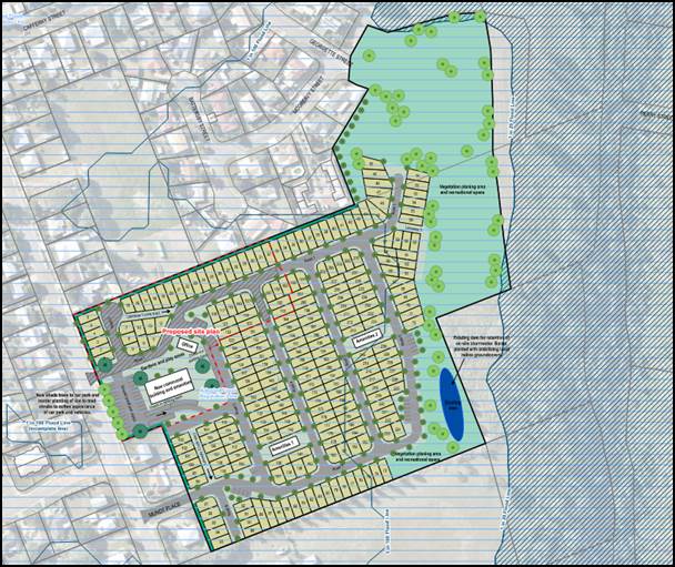
|
LEGEND
Proposed development extent
Planned future expansion
|
SITE DETAILS AND SURROUNDING LAND USES:
Site Description
The subject site is located at the end of Chubb Street, One Mile, which is a 1.5km long cul-de-sac road. The site was once the location of a gym, squash and tennis courts but is now primarily used for grazing purposes with a number of horses now appearing to be agisted on the property. The site, which is 6.664ha in area, is relatively flat but has a gentle slope from west to east. The site levels range from 26.4m AHD in the centre of the site to 17.2m AHD in the east (adjacent to the Bremer River). Of key interest is the fact that the Chubb Street frontage sits at 25m AHD with the majority of the site ranging from 25m – 25.5m AHD.
The site is currently improved by a large building that previously contained the gym and squash courts as well as some internal road infrastructure that was built in 2010 in order to facilitate a retirement community that was previously approved by Council. Further details in relation to this previous approval have been included below.
Zoning
The subject site is zoned both Recreation (48%) and Large Lot Residential (52%) with the proposed development located entirely within a portion of the site that zoned Recreation.
Surrounding Land Uses
The subject site adjoins existing Low Density Residential uses as well as vacant Large Lot Residential and Recreation Zoned land to the north, a Large Lot Residential property improved by a Single Residential Use to the south, Recreation Zoned land owned by Council (including Georgette Street Reserve) to the east and existing Low Density Residential uses to the west that also front Chubb Street.
Flooding
The subject site is impacted by the Adopted Flood Regulation Line (AFRL) overlay with an identified flood height of 25.7m AHD. This results in most of the site being inundated during the identified flood event. In addition, and of particular concern to the assessment manager is the way the flood hazard interacts with the access points for the subject site as well as the Chubb Street road formation.
Access to the site can be gained from Chubb Street and Mundt Place in the west and Georgette Street to the north. The Chubb Street access (the proposed access point for the development) would be impacted by up to 700mm of water in the identified flood event with the Mundt Place and Georgette Street accesses subject to 700mm and 6.7m of flooding respectively.
As outlined above, the proposed access to the development is subject to an inundation level of 700mm however the road formation of Chubb Street adjacent to the access point is situated at 24.5m AHD. As such, the extent of inundation for access to the subject site is actually 1.2m. Further compounding any concern with the impact that flooding has on the site and the proposal is the fact Chubb Street (the only evacuation route) will be subject to a greater depth of flooding than the subject site and will therefore result in an inability to evacuate earlier than the flood impact to the site itself. It is also noted that during an identified flood event the evacuation route will be inundated for approximately 275m and approximately 145m (up to a depth of 500mm) when the development site begins to be impacted.
Site History
In 2006 Council approved a Material Change of Use (MCU) over the subject site for 118 aged accommodation units and ancillary recreation facilities. This was then followed by a reconfiguration of a lot (RAL) approval in 2010 to facilitate a standard format lot with Community Management Scheme associated with the first 42 units associated with the 2006 approval. The RAL was conditioned with a relevant period up until 19 March 2011 to be in line with the relevant period associated with the MCU.
Whilst a developer commenced construction of the MCU development in 2010 (as is evident by the existing internal road infrastructure), based on available information it appears that construction works ceased some time between June 2010 and January 2011.
In January 2011 major flooding hit the city of Ipswich and the subject site was partially inundated (this flood peaked at 22.6m AHD for the subject site). In March 2011 the applicant requested an extension of one (1) year for both the MCU and RAL citing funding issues as the key reason that the development was not progressing. At that time the development was consistent with the relevant assessment benchmarks and therefore a 12 month extension was permitted.
On 14 June 2011 Council adopted the Temporary Local Planning Instrument 01/2011 (TLPI). This TLPI, which commenced on 20 June 2011, changed the effect of the planning scheme to the extent that it related to flooding such that the intensification of residential uses on land between the 1 in 20 and the Adopted Flood Regulation Line were no longer supported.
In March 2012, with limited progress made on the development, the applicant again sought a 12 month extension for both the MCU and RAL. Owing to the fact that the TLPI had now commenced, both proposals were no longer consistent with the relevant benchmarks. To this end and in accordance with the provisions of the Sustainable Planning Act 2009 and the TLPI, both requests were refused in May 2012.
This outcome has meant that no further works have taken place on the site pursuant to the previous approvals and the site has sat in its current state ever since. It is worth noting that the site has been on-sold since the original approvals were issued with the latest sale taking place in November 2021 (according to Council records)
PROPOSAL:
Proposal Description
The proposal is for a 46-site camping ground and caravan park supported by a communal facilities and amenities building located within the former gym/squash court building as well as an office, garden and play area. All sites are proposed to be supplied with power. The proposal also includes 28 parking spaces, two of which are sized to accommodate larger vehicles/vehicles with trailers for check in purposes. A single access point is proposed to be provided from Chubb Street generally located halfway between 80 and 96 Chubb Street, opposite 109 and 111 Chubb Street.
The proposed development consists of 6 sites that would have a direct frontage to Chubb Street with the remaining sites situated at the rear and gaining access off the driveway/road that was built as part of the previously approved aged accommodation units. The existing open parking area located at the front of the site is proposed to be maintained between the access driveway and 96 Chubb Street and is proposed to be utilised for visitor and guest parking.
It is also worth noting that the applicant has provided plans showing future stages for the development however these do not form part of the current assessment. The applicant has also stated that the balance of the site will be maintained as public open space however it is unclear how this would be provided as public open space and further how the applicant proposed to provide lawful access in perpetuity.
Defined Use
A camping ground and caravan park is defined as a Temporary Accommodation Use pursuant to the Ipswich Planning Scheme and is intended for the provision of accommodation for a period of less than 60 days duration. As part of the development application, the applicant did not provide any detail regarding how this would be managed in perpetuity. Of concern to the assessment manager is the fact that without strong and enforceable management practices the use could result in occupants of the site becoming permanent.
Challenges
As part of this development application the applicant acknowledged a number of challenges that exist with the site. Below is a summary of the challenges that exist, how the applicant has attempted to overcome these challenges, and matters that are still of concern to Council assessing officer:
Flooding and Evacuation
The applicant has acknowledged that there are major flooding impacts on the site and therefore a need for safe evacuation in a flood event. In order to attempt to overcome this major issue the applicant provided a flood risk management plan (FRMP) prepared by BMT. As part of the assessment process, Council officers raised concerns with the FRMP. More specifically, Council officers requested additional information via a formal information request dated 1 February 2022. In response the applicant submitted an amended FRMP, which recommended the following:
Operational Requirements:
· Warning signs erected around the site and handouts provided to each occupier of the site outlining the flooding impacts the site is subject to;
· Flood warning ascertained from existing third-party flood gauges and other sources e.g. Bureau of Meteorology. This requires monitoring and interpretation by a site manager;
· Requirement for a site manager including consideration regarding leave arrangements;
· Staff training in site operation during a flood event; and
· Annual evacuation drills.
Evacuation requirements:
· Onsite management of the identification of evacuation need; and
· Evacuation via Chubb Street to a Council operated evacuation centre.
Despite the information provided (including an update of the FRMP in response to Council’s Information Request), Council assessing officers are of the strong view that the proposed development is unacceptable having regard to matters relating to flooding as it presents an unacceptable risks to people and property.
The Council assessing officers’ concerns are summarised as follows:
· Natural disasters are stressful events and can result in changes to people’s behaviours;
· Sole reliance on existing flood monitoring gages and weather forecasts does not accurately reflect the flooding impact to the subject site or the risk applicable to the site owing to location, transmission delays of information and potential failure/inability/difficulty to access information during a natural disaster.
· Reliance on a site manager to undertaken 24 hour monitoring of weather and flooding conditions and accurately interpret and apply the FRMP during a natural disaster is unacceptable;
· The fact that Chubb Street (the main evacuation route) floods before the subject site is of major concern as this results in an inability to evacuate earlier than the flood impact to the site itself;
· The fact that a complete flood evacuation route has not been provided (i.e. only Chubb Street is identified) is unacceptable;
· The proposal does not support and in fact will hinder disaster management response capacity and capabilities by increasing the number of displaced people during a flood event; and
· The reliance on a Council operated evacuation centres which reduces available capacity for existing residents is of major concern and is unacceptable.
Amenity Impacts
Whilst the applicant has acknowledge that the proposal will form part of an established residential neighbourhood, the applicant provided limited information about how they would manage and mitigate any impacts on the streetscape and adjoining residents both from a visual and acoustic perspective.
Of particular concern is the fact that the application was not supported by an appropriate acoustic report. Through the information request process the applicant was requested to provide a report that identified any impacts the development would likely have on adjoining and nearby residents and provide mitigation strategies to address any impacts. The applicant did not provide any reporting in response to Council’s request. Rather, the applicant stated that the separation distances to existing dwellings as well as the residential nature of the proposed use did not require an assessment and no mitigation measures were proposed. As such it is not clear whether or not the use is appropriate from an acoustic perspective or whether any required mitigation would be appropriate for the context including but not limited to impacts on the Chubb Street streetscape.
As such, and as outlined in the balance of this report the proposal offends the applicable benchmarks and has not appropriately demonstrated that risk to people and property are mitigated.
PLANNING FRAMEWORK
2017 Regional Plan, (ShapingSEQ)
The land is included within the Urban Footprint.
The Ipswich Planning Scheme 2006 (the 2006 Scheme)
Pursuant to the 2006 Scheme the land is:
(a) partly within the Recreation Zone (Part 4, division 17);
(b) partly within the Large Lot Residential Zone (Part 4, division 4);
(c) subject to a number of overlays, in particular the Development Constraints Overlay;
(d) by virtue of the proposed uses, subject to the Residential Code (Part 12, division 6).
(e) by virtue of the proposed uses, subject to the Parking Code (Part 12, division 9).
Draft Ipswich Planning Scheme 2019 (Statement of Proposals) (the draft scheme)
Pursuant to the terms of the draft scheme, the land is proposed to be rezoned from Large Lot Residential (accessed from Georgette Street) to Environmental Management and Large Lot Residential (accessed from Mundt Place) to Recreation and Open Space. In addition, the portion of the site currently zoned Recreation is proposed to be rezoned to Environmental Management.
Legal/Policy Basis
This report and its recommendations are consistent with the following legislative provisions:
§ Planning Act 2016
§ Planning Act 2016 – Planning Regulation 2017
§ Ipswich Planning Scheme 2006
Ipswich Planning Scheme 2006 RISK MANAGEMENT IMPLICATIONS
§ A risk to Council exists should the proposal not be determined in accordance with legislative requirements. The assessment and subsequent recommendation have been prepared to minimise the risk.
§ Pursuant to DA Rules the due date to make is decision on this application is 22 September 2022 and the due date to issue the decision notice to the applicant is 29 September 2022. The applicant could lodge a deemed refusal appeal in the P&E Court if the decision notice is not issued to the applicant by 29 September 2022.
§ Upon issuing the decision notice the applicant may choose to appeal the Council’s part approval and part refusal decision in the Planning and Environment Court.
HUMAN RIGHTS IMPLICATIONS
|
HUMAN RIGHTS IMPACTS |
|
|
OTHER DECISION |
|
|
|
|
|
(a) What is the Act/Decision being made? |
Decision to refuse development application 19904/2021/MCU - Chubb Street, One Mile
|
|
(b) What human rights are affected? |
The applicant is a company and therefore does not have human rights under the Human Rights Act 2019.
Fifty-six (56) properly made submissions were made in relation to the application, and therefore Council has an obligation to consider human right in relation to the submitters. The submitter does have appeal rights pursuant to the Planning Act 2016.
The proposed decision does not have the potential to restrict or interfere with the right to privacy because before a person makes a submission regarding a development application they are provided advance notice (via Council’s website) that it is a requirement under the Planning Act 2016 that contact details of all properly made submitters be included on any decision notice and therefore they have the ability of consider whether to proceed with making a submission in spite of the legislatively required disclosure of their personal information.
In acknowledging a properly made submission, Council provides a letter to submitters advising them of this statutory requirement.
In the instance, the submitter’s personal information is already published on ePathway as the submitter did not advise Council that they did not want their personal information to be published (this opportunity is provided upon lodgement of submission), the submitter may request that the information be removed from ePathway and may also choose to withdraw their properly made submission should they not want their details to be included on the decision notice in accordance with statutory requirements |
|
(c) How are the human rights limited? |
Not applicable. No human rights will be limited by the decision.
|
|
(d) Is there a good reason for limiting the relevant rights? Is the limitation fair and reasonable? |
Not applicable.
|
|
(e) Conclusion |
The decision is consistent with human rights. |
Financial/RESOURCE IMPLICATIONS
There are no resource implications associated with this report.
COMMUNITY and OTHER CONSULTATION
INTERNAL CONSULTATION
The application and common material was presented to Council’s Initial Development Assessment Panel (consisting of various representatives from across the organisation) for review upon lodgement. At this meeting, it was determined that internal referral was required to the Engineering, Health and Environment Branch.
The following assessment reports were prepared and have been incorporated into the recommendation:
- Engineering report dated 1 July 2022 with recommended reasons for refusal relating to lack of independent evacuation/shelter location (i.e. not reliant on existing evacuation centres), no identification of a flood free evacuation route to evacuation/shelter location and on-site monitoring proposed;
- Environment report dated 27 June 2022 with recommended reasons for refusal relating to loss of acoustic amenity for existing residents of the locality.
- Infrastructure and Environment Department (Hydraulics) and Council’s Emergency Management Unit prepared combined comments which highlighted the following concerns which have been incorporated into this recommendation:
o The use cannot shift responsibility (both liability and cost) for displacement of users onto Council;
o Evacuation Centres are a place of last resort and a flood management plan should not rely on the opening of evacuation centres and is against the accepted notion of disaster resilience;
o Concern that the use will rely on Council alerts and warnings rather than have a dedicated Emergency Management Team that specifically manages the site; and
o Concerns with the impact that evacuating vehicles and vans will have on the road network during a flood response;
PUBLIC NOTIFICATION:
Public notification of this application was undertaken pursuant to the Planning Act 2016. The applicant undertook public notification from 16 June 2022 to 7 July 2022 for a period of 15 business days. During this period Council received 73 submissions, 56 of which are properly made, all objecting to the proposed development. Matters raised in the submissions include:
|
How matters were dealt with in reaching a decision |
|
|
Flooding § The Planning Scheme provisions relating to land below the Adopted Flood Regulation Line does not allow for intensification of Residential Uses including Temporary Accommodation. § Concern that failure to evacuate/remove caravans/campers will result in them becoming mobile in flood waters and damaging adjoining and downstream properties. § Damage to person and property related to relocation of rubbish generated by the site onto adjoining and downstream properties during flood events. |
While some matters raised could be resolved through reasonable and relevant conditions, there are certainly matters for which Council agrees with the submitters concerns.
The issues associated with this proposal mean that the Ipswich community will not benefit from approval of the proposed development in any material respect and the adverse risks and consequences of approval outweigh any benefits.
In conclusion the development cannot be appropriately conditioned to address all matters raised and there are insufficient grounds to justify the decision to approve the development.
|
|
Amenity § Increased noise pollution related to increase in traffic related to the use. § Loss of privacy. § Poor visual amenity from a streetscape and adjoining property perspective. § Detrimental impacts to existing residents’ quiet enjoyment of their properties.
|
|
|
Use § Inappropriate location for use.
|
|
|
Traffic, Road Network and movement network capacity § Traffic congestion within the general vicinity of the proposal related to increase vehicle trips and service vehicles required by the use. § Increased traffic both number and size will cause increased damage to road surfaces. § Road safety concerns related to the increased traffic associated with the use and the condition, width and construction of the existing road network. § No waste/refuse management details provided by applicant so concerns raised about noise and traffic movement. § Poor pedestrian connectivity to and from the proposal.
|
|
|
Environmental (Flora, Fauna and Environs) § Detrimental impacts to native flora and fauna. § Concern with detrimental impacts to the Bremer River.
|
|
|
Stormwater management § Concern that the use will create stormwater quantity issues on adjoining properties.
|
|
|
Earthworks § Earthworks will detrimentally impact flood levels in the area.
|
|
|
Insufficient supporting infrastructure § Insufficient capacity in emergency services, health care, parks, community facilities, electricity and water and sewer networks within the locality to support the proposal.
|
|
|
Public Notification § Concerns with veracity, scale and nature of the public consultation process. § Insufficient information provided in the common material about the proposal.
|
|
|
General concerns (Not planning grounds) § Reduced property values. § Increased criminal/anti-social behaviour. § Exploitation of vulnerable populations. § Concerns with demographics of end users.
|
|
|
Submission of Support
Housing choice and availability The proposal will provide much needed accommodation for displaced individuals and families owing to the lack of rentals. |
SUMMARY OF ASSESSMENT AND RECOMMENDATION/S
The proposed development is recommended to be refused on the basis that the proposal conflicts with the assessment benchmarks set out by the categorising instruments in accordance with section 45(5)(a)(i) of the Planning Act 2016.
The relevant assessment benchmarks which have been applied for the purposes of this assessment are as follows:
|
Categorising Instrument |
Assessment Benchmarks |
|
State Planning Policy July 2017, Part E |
Planning for liveable communities and housing Planning for economic growth Planning for environment and heritage Planning for safety and resilience to hazards Planning for infrastructure |
|
Ipswich Planning Scheme 2006 |
Desired Environmental Outcomes and Performance Indicators (Part 3) Urban Areas Code (Part 4) Development Constraints Overlays Code (Part 11, division 4) Residential Code (Part 12, division 6) Parking Code (Part 12, division 9) Planning Scheme Policy 3 General Works Planning Scheme Policy 5 Infrastructure Implementation Guideline No. 13 Provision of Electricity, Driveways and Crossovers, Footpaths, Kerb and Channel Implementation Guideline No. 24 Stormwater Management |
The assessment was also required to give regard to the relevant matters identified in section 31 of the Planning Regulation 2017 in accordance with section 45(5)(a)(ii) of the Planning Act 2016.
The assessment had regard to the following matters:
|
Relevant matter |
Given regard to |
|
Planning Regulation 2017, s27(1)(d) |
(i) the regional plan for a region, to the extent the regional plan is not identified in the planning scheme as being appropriately integrated in the planning scheme; and (ii) the State Planning Policy, to the extent the State Planning Policy is not identified in the planning scheme as being appropriately integrated in the planning scheme; and (iii) for designated premises—the designation for the premises; |
|
Planning Regulation 2017, s31(1)(f) |
any development approval for, and any lawful use of, the premises or adjacent premises; and |
|
Planning Regulation 2017, s31(1)(g) |
the common material. |
The assessment was also carried out having regard to other relevant matters in accordance with section 45(5)(b) of the Planning Act 2016.
The assessment had regard to the following matters:
|
Relevant matter |
Assessed against or had regard to |
|
Draft Ipswich Planning Scheme 2019 |
Regard was given to the Draft Ipswich Planning Scheme (Draft Scheme) as a relevant matter to the application.
The draft scheme has undergone community consultation on the Statement of Proposal, including the draft Strategic Framework.
Based on the supporting material provided by the applicant, it is considered that the proposed development does not comply with the draft scheme as it proposes to intensify a residential use within areas identified within the Draft Scheme as subject to a Defined Flood Event (Moderate Risk). Further it is noted that the site is not identified as being within a Special Flood Resilient Precinct where sufficient warning time and appropriate design and construction may permit residential uses to be supported. |
The key issues associated with the proposal which form the basis upon why the proposed development is recommended to be refused can be summarised as follows:
Flooding and Evacuation
The proposed development is unacceptable having regard to matters relating to flooding and presents an unacceptable risks to people and property, in particular:
(a) The proposal represents intensification of residential uses within a flood affected area on land situated below the adopted flood regulation line, including the development of temporary accommodation uses.
(b) The proposal does not avoid natural hazard areas, cannot avoid the natural hazard area on the subject site and has not demonstrated that it mitigates the risks to people and property to an acceptable or tolerable level.
(c) The proposal does not support and in fact will hinder disaster management response capacity and capabilities by increasing the number of displaced people during a flood event.
(d) The proposal has not demonstrated that the health and safety of people is maximised.
(e) The proposal has not demonstrated that it will be located and designed or able to be operated in a manner which provides a safe environment for residents and visitors.
(f) The proposal is the intensification of a residential use within the Defined Flood Event (Moderate Risk) Overlay within the Statement of Proposals for the Draft Ipswich Planning Scheme 2019 and further is not located within a Special Flood Resilient Precinct.
(g) The proposal has not demonstrated that the effects of climate change will be managed to optimise safety and resilience for the community in which it is located.
(h) The proposal does not represent part of a community that is designed and equipped to be safe, hazard-resilient places.
(i) The proposal has not demonstrated that the risks associated with natural hazards, including the projected impacts of climate change, are avoided or mitigated to protect people and property and enhance the community’s resilience to natural hazards.
(j) The proposal represents development that is not appropriately responding to the state interests in the State Planning Policy and as such is not appropriate development.
(k) The proposal is not designed to minimise risks and nuisance to people and property.
(l) The proposal is not designed to include mitigation measures that reduce the inherent risk from the hazard to a tolerable or acceptable level.
(m) The proposal has not demonstrated that it has adequate evacuation routes and emergency service access during a natural hazard event.
Unacceptable Amenity Impacts
The proposed development is unacceptable having regard to matters relating to residential amenity, in particular:
(a) The proposal has not demonstrated that the amenity that existing residents enjoy will be maintained and enhanced.
(b) The proposal has not demonstrated that it will create a pleasant and safe living environment for existing residents.
(c) The proposal is not located to minimise risks and nuisance to people and property.
(d) The proposal has not demonstrated that it will be compatible with other uses and works.
(e) The proposal has not demonstrated that the health of the local government’s population will be protected.
(f) The proposal has not demonstrated that it will blend into the existing streetscape and neighbourhood.
(g) The proposal is not designed and sited to provide a high degree of amenity in a residential environment.
Zone Intent
The proposed development is unacceptable having regard to the intent of the Recreation Zone in which the site is located, in particular:
(a) The proposal does not provide for the development of an integrated open space network including the use of land for—
(i) both active and passive recreation opportunities within parks.
(ii) linear/riparian corridors as open space links; and
(iii) private and public sporting/recreation facilities.
(b) The proposal will sterilise land through the use for Residential purposes within the Recreation Zone which should be providing sufficient land—
(i) to meet the recreational needs of residents and visitors within Citywide, district and local catchments; and
(ii) to achieve an equitable distribution of recreational areas and facilities in suitable and accessible locations.
(d) The proposed Environmental Management Zoning (and therefore future planning intent of the land) as identified within the Statement of Proposals for the Draft Ipswich Planning Scheme 2019, is compatible with the hazard and associated level of risk for the subject site and demonstrates a clear intent that residential uses should not occur on the subject site.
The key issues summarised above have been expanded upon below for further context.
Flooding
All relevant assessment benchmarks, including the South East Queensland Regional Plan 2017, State Planning Policy 2017 (SPP) and Ipswich Planning Scheme 2006 (the Scheme) highlight that South-East Queensland communities are to be planned, designed and constructed to respond to the increasing frequency and magnitude of flood events (including planning for ongoing changes related to the effects of climate change).
The subject site is zoned Recreation which seeks to facilitate the establishment of an integrated open space network including the use of land for both active and passive recreation opportunities within parks, linear/riparian corridors as open space links, and private and public sporting/recreation facilities. This is further underlined by the location of Future Citywide Sports Grounds (Reference Number: 934) over part of the subject site. This is an outcome commensurate with the context of the subject site.
While it is noted that Temporary Accommodation (Camping Ground and Caravan Park) is subject to Impact Assessment (rather than being considered Impact Inconsistent), this can only be considered appropriate if all applicable assessment benchmarks are complied with including demonstrating that the establishment of an integrated open space network is not jeopardised and further that the applicable overlay benchmarks are not offended.
The subject site is impacted by the Adopted Flood Regulation Line (AFRL) overlay for the majority of the site. Temporary Accommodation (regardless of the nature) is considered a residential use pursuant to Schedule 1 – Dictionary of the Ipswich Planning Scheme 2006.
As clearly outlined in Part 11, Division 4 – Development Constraints Overlay, section 11.4.7 (1)(c)(i) of the Planning Scheme, no intensification of a residential use is permitted (including Temporary Accommodation) within flood affected areas on land situated below the AFRL. It is also noted that a performance-based outcome is only provided for within limited zones and circumstances deemed appropriate. Specifically, a performance-based outcome is limited to areas zoned for medium and high-density housing or for mixed use / centre development of which the subject site is not.
As outlined above, the draft scheme shows intent to rezone the Large Lot Residential (accessed from Georgette Street) to Environmental Management (including the existing area of Recreation Zone) and Large Lot Residential (accessed from Mundt Place) to Recreation and Open Space in line with the planned City Wide Sports Ground pursuant to the Local Government Infrastructure Plan. This further clarifies that the zone intent for the site the subject of the current proposal remains inappropriate for residential development.
Further underlining this is the fact that the draft scheme maps ‘Housing Areas’. This designation is included to show the distribution of land identified to accommodate the diversity of housing to meet the projected population growth and housing needs and to support the efficient and cost-effective provision of state government infrastructure, council trunk infrastructure, other supporting infrastructure and utilities. It is noted the subject site is excluded from a neighbourhood designation which gives further weight to the fact that the subject site is inappropriate for residential development
In addition, it is noted that Chubb Street (the primary evacuation route) is impacted by a flood event to a greater extent than the subject site. This further underlines the inappropriate nature of the development for the subject site.
Evacuation
A key way flood risk is managed is providing for the safe and efficient evacuation and shelter of those impacted by a flood event. The applicant was requested to demonstrate that flood free access could be provided from the subject site to an independent evacuation centre/site. This was not provided. Instead the applicant proposes to rely on existing emergency evacuation centres and further did not demonstrate flood-free access from the site to an evacuation centre other than to identify Chubb Street as the evacuation route.
As outlined in the SPP and the Planning Scheme, development within a natural hazard area (e.g. flooding) must support and not hinder disaster management response and capabilities. The proposal is considered to represent a use (compounded by the location and proposed use of existing evacuation centres) that will detrimentally impact disaster management response and capabilities. This is directly related to the fact that there is uncertainty about where guests would be evacuated to, how they will be successfully evacuated at the height of a natural disaster, what impacts the evacuation will have on the functionality of the broader road network already likely heavily constrained by an ongoing natural disaster and finally the loss of evacuation shelter capacity specifically provided for existing residents impacted by a flood event approved/delivered prior to a clear and strong policy position prohibiting the intensification of residential uses within impacted areas.
Acoustic Amenity
Uses such as camping grounds and caravan parks have the potential to generate significant acoustic impacts, which is of particular concern when located within close proximity to sensitive receivers including residential dwellings. The proposal locates camp sites directly adjacent to and opposite existing residential properties. The applicant did not respond to Council’s information request seeking details about what impacts are possible, how they are proposed to be mitigated and how the required mitigation measures fit into the applicable assessment benchmarks for the site. As no information has been provided, the use has not appropriately demonstrated that the location and site layout is appropriate to manage the acoustic amenity of existing residents.
Zone intent
The subject development is located within a portion of the site that is zoned Recreation pursuant to the current planning scheme and Environmental Management pursuant to the draft scheme.
The intent of the Recreation Zone is to deliver an integrated open space network for the city and sets a clear intent for the type of development that should occur within these areas. As outlined above it is noted that Temporary Accommodation is subject to Impact Assessment. Pursuant to the relevant Table of Development Assessment this is only appropriate if of a type and scale appropriate for the prevailing nature of the area and the particular circumstances of the site and its surrounds. Given the issues, the most appropriate use for the site would be to provide a public or private recreation facility, such as sporting fields/courts, to the extent it complies with the relevant overlay requirements for the particular use.
As outlined above, the draft scheme identifies the site as being subject to an Environmental Management Zone which is used for areas located along the Bremer River (which frames the Area’s western, southern and eastern boundaries) providing substantial riparian ecological corridors and local, district and citywide parkland and sports grounds. This is further reinforced by the fact that the subject premises is not located within the Special Flood Resilient Precincts as outlined in the flooding section above.
Conclusion
An assessment of the proposal as described above has been undertaken and it has been determined that the proposed Temporary Accommodation (Camping Ground and Caravan Park - 46 sites) conflicts with the applicable assessment benchmarks, matters prescribed by regulation and other relevant matters It is therefore recommended that the development application be refused for the reasons as contained in ‘
Attachments and Confidential Background Papers
|
1. |
19904/2021/MCU Proposal Plans ⇩ |
|
2. |
19904/2021/MCU Draft Decision Notice (includes Reasons for
Refusal) ⇩ |
|
3. |
19904/2021/MCU Draft Statement of Reasons ⇩ |
Matthew Buchanan
Senior Planner (Development)
I concur with the recommendations contained in this report.
Michael Simmons
Development Assessment West Manager
I concur with the recommendations contained in this report.
Anthony Bowles
Manager, Development Planning
I concur with the recommendations contained in this report.
Peter Tabulo
General Manager Planning and Regulatory Services
“Together, we proudly enhance the quality of life for our community”
|
Growth Infrastructure and Waste Committee Meeting Agenda |
15 September 2022 |
ITEM: 6
SUBJECT: Regionally Significant Project Proposal - Ipswich Bus Network Expansion
AUTHOR: Senior Transport Planner
DATE: 23 August 2022
Executive Summary
This is a report concerning the Ipswich Bus Network Expansion Project and the opportunity to declare this as a project of regional significance.
Recommendation/s
A. That Council accept the Ipswich Bus Network Expansion project as regionally significant.
B. That the Ipswich Bus Network Expansion project be taken to the next Advocacy Steering Group meeting for consideration of the appropriate advocacy effort.
RELATED PARTIES
There is no declaration of conflicts of interest regarding this report.
ifuture Theme
Vibrant and Growing
Purpose of Report/Background
A report titled ‘Expanding the Ipswich Bus Network’ was presented at the February 2022 Growth Infrastructure and Waste Committee (Attachment 1). Recommendation A of the attached report called for a submission for citywide expansion of the bus network to be prepared and considered as a potential Regionally Significant Project.
At the request of the Regionally Significant Project Prioritisation Group (RSPPG) and pre-emptive of the February 2022 GIW Committee report, a Regionally Significant Project Submission (Attachment 2) was sent to the RSPPG in January 2022.
This project submission outlines the need for an advocacy program, centered around a list of priority projects (jointly negotiated between TransLink and Council). The need for ‘Regionally Significant’ project status for this program is to achieve greater institutional support and coordination in the objective of achieving more investment for the bus network in the City of Ipswich.
The RSPPG endorsed the submission at their meeting on 23 February 2022. As a result, this project was submitted to the Executive Leadership Team (ELT) for approval.
During the ELT meeting on 4 July 2022, a question was asked as to what success would be for this nominated regionally significant project. Put simply, success through advocacy would be a significant and sustained increase of investment by the State Government in the Ipswich bus network. It is proposed that the first but important step in this success would be investment in two identified critical and priority service improvements identified below:
· An expansion of the bus network within Redbank Plains (south of Redbank Plains Road)
· A trunk bus connection between Ipswich Central and Springfield Central
The ELT endorsed the recommendation to include the project as regionally significant on 11 July 2022.
Legal/Policy Basis
Advocacy for Regionally Significant Projects Policy
RISK MANAGEMENT IMPLICATIONS
Whilst Council and TransLink are aligned strategically from a network planning perspective, funding is the roadblock to progress.
If future investment in the bus network from the State Government is not forthcoming, bus patronage in Ipswich may continue to decrease. On the current trajectory whereby investment in the bus network has not kept up with residential growth, the public transport mode share within Ipswich will continue to decline, shifting further away from the 11% mode share target identified in iGO, the City of Ipswich Transport Plan.
The risk of not servicing growth areas with public transport is that these communities establish habits/patterns of car usage, which is difficult to break once established, leading to greater congestion on roads, pollution as well as various social-economic issues.
HUMAN RIGHTS IMPLICATIONS
|
HUMAN RIGHTS IMPACTS |
|
|
OTHER DECISION |
|
|
(a) What is the Act/Decision being made? |
Recommendation A states that Council accept the Ipswich Bus Network Expansion project as regionally significant Recommendation B states that the Ipswich Bus Network Expansion project be taken to the next Advocacy Steering Group meeting for consideration of the appropriate advocacy effort.
|
|
(b) What human rights are affected? |
Human rights are not affected by these decisions as this relates to a procedural matter about the significance of a project to Ipswich and the actions Council will take as a result of a regionally significant project declaration. Any actions relate to Council’s engagement with government to seek funding and support for the project only.
|
|
(c) How are the human rights limited? |
Not applicable
|
|
(d) Is there a good reason for limiting the relevant rights? Is the limitation fair and reasonable? |
Not applicable
|
|
(e) Conclusion |
The decision is consistent with human rights. |
Financial/RESOURCE IMPLICATIONS
There are no financial implications for Council consideration in association with this report.
COMMUNITY and OTHER CONSULTATION
No external consultation has been undertaken in association with this report.
A summary of the consultation process undertaken as part of the Ipswich Bus Network Expansion project can be found in Attachment 2.
Conclusion
The Ipswich Bus Network Expansion project has been assessed as meeting the Council’s benchmarks for a regionally significant project and if delivered would bring significant social, economic and environmental benefits to Ipswich. On this basis, officers are recommending that this project be declared regionally significant.
Attachments and Confidential Background Papers
|
1. |
GIW Committee Report (10 February 2022) - Expanding the
Ipswich Bus Network ⇩ |
|
2. |
Regionally Significant Project Submission - Ipswich Bus
Network Expansion Project ⇩ |
James MacArthur
Senior Transport Planner
I concur with the recommendations contained in this report.
Mary Torres
Infrastructure Strategy and Planning Manager
I concur with the recommendations contained in this report.
Tony Dileo
Manager, Infrastructure Strategy
I concur with the recommendations contained in this report.
Sean Madigan
General Manager - Infrastructure and Environment
“Together, we proudly enhance the quality of life for our community”
|
Growth Infrastructure and Waste Committee Meeting Agenda |
15 September 2022 |
ITEM: 7
SUBJECT: Adoption of the three year new kerb and channel capital program
AUTHOR: General Manager - Infrastructure and Environment
DATE: 10 August 2022
This is a report concerning the three-year new kerb and channel capital program.
Council officers have applied the statistical methodology in combination with input from the community via the Divisional Councillors to finalise the three-year kerb and channel program.
The recommended program provides a better outcome for the community and is deliverable within the adopted three-year capital program and budget.
Recommendation/s
That Council adopt the three-year program for new Kerb and Channel as specified in the attachment to this report.
RELATED PARTIES
There are no known conflicts of interest in relation to this report.
ifuture Theme
Vibrant and Growing
Purpose of Report/Background
When Council adopted the 2022-2023 budget in June of this year, Council allocated $3 million per annum for new kerb and channel projects across the city. At the time of adopting the budget, officers were not in position to put forward a recommended three-year program for new kerb and channel that could be delivered within the allocated budget and timeframes.
Since the adoption of the budget, Council officers have reviewed the new kerb and channel program in terms of the allocated budget and timeframes. Officers have also met with Divisional Councillors to discuss community needs for new kerb and channel.
Following this consultation process, the attached new kerb and channel program is put forward by officers to be adopted by Council.
Legal/Policy Basis
This report and its recommendations are consistent with the following legislative provisions:
Local Government Act 2009
RISK MANAGEMENT IMPLICATIONS
At this time, Council does not have an approved program for new kerb and channel across the city. If Council were to not approve the recommended program there will be delays in delivering new kerb and channel for the community.
HUMAN RIGHTS IMPLICATIONS
|
HUMAN RIGHTS IMPACTS |
|
|
OTHER DECISION |
|
|
|
|
|
(a) What is the Act/Decision being made? |
That Council adopt the recommended 3-year new kerb and channel program.
|
|
(b) What human rights are affected? |
No human rights are affected by this decision.
|
|
(c) How are the human rights limited? |
Not applicable
|
|
(d) Is there a good reason for limiting the relevant rights? Is the limitation fair and reasonable? |
Not applicable.
|
|
(e) Conclusion |
The decision is consistent with human rights. |
Financial/RESOURCE IMPLICATIONS
In the budget adopted by Council in June 2022 Council allocated $3 million in the 2022-2023 financial year. The recommended new kerb and channel program has a required budget of $2.724M for the 2022-2023 financial year. The entire 3-year program has been costed at $9.618M and it is considered that this can be delivered within the capital budget allocations for the second and third years as the annual budgets are developed.
COMMUNITY and OTHER CONSULTATION
The Divisional Councillors were consulted in relation to the new kerb and channel program. This provided Council officers with an appreciation of the community needs and requests for new kerb and channel and enable officers to better prioritise the three-year program.
Conclusion
It is recommended that Council adopt the new kerb and channel program attached to this report, to provide for the infrastructure needs of the community.
Attachments and Confidential Background Papers
|
1. |
New kerb and channel project list 2022-2024 ⇩ |
Sean Madigan
General Manager - Infrastructure and Environment
I concur with the recommendations contained in this report.
Sean Madigan
General Manager - Infrastructure and Environment
“Together, we proudly enhance the quality of life for our community”
|
Growth Infrastructure and Waste Committee Meeting Agenda |
15 September 2022 |
ITEM: 8
SUBJECT: Alternative Road Surfacing Options
AUTHOR: Manager, Asset Services
DATE: 5 September 2022
Executive Summary
This is a report concerning industry information requested from the Queensland Branch of the Australian Flexible Pavements Association (AfPA) of the residential road resurfacing treatments available. The report is developed in continuance of the Notice of Motion – Spray Seal Maintenance Treatments Report.
Recommendation/s
That the report on alternative road surfacing options be received and the contents noted.
RELATED PARTIES
There are no known conflicts of interest in relation to this report.
ifuture Theme
Vibrant and Growing
Purpose of Report/Background
In response to a request regarding alternative road resurfacing options, Infrastructure and Environment Department (IED) have contacted the Queensland Branch of the Australian Flexible Pavements Association (AfPA) to inquire about the products and services offered by their members (See Attachments). They have provided a range of options available for the resurface treatments suitable for residential roads and the brochures supplied are attached for review.
An overview of the products available and offered by AfPA members are;
1. SRS SealCoat (Spray Seal Treatment)
SRS SealCoat is applied to an existing road surface. It is a mixture binder and aggregate that can range from 4mm to 7mm. It is a micro-surfacing sealant designed to extend the life of existing bituminous surfaces. By combining SRS SealCoat’s high adhesive characteristics with polymer modifiers and varied quantities of solids to suit the condition of individual pavements, SRS SealCoat will seal and protect the pavement. The loss of larger stones, cracking, water penetration and accelerated failure with time. Without timely intervention, the cost of repairing pavement increases substantially.
Price range $7-10/m2 and an expected surface life is 8-10 years.
2. SRS SealCoat + (Spray Seal Treatment)
SRS SealCoat+ is applied to an existing road surface. It is a mixture binder and aggregate that can range from 4mm to 7mm. It is a more durable product than SRS SealCoat, with a higher premium adhesive characteristic and polymer modifiers and they are more suitable for airport runways because it is more durable and flexible.
Price range $10-15/m2 and an expected surface life of 8-10 years.
3. FRM SealCoat (Spray Seal Treatment)
FRM SealCoat is applied to an existing road surface. It is a mixture binder and aggregate that can range from 4mm to 7mm. It is the most durable product of all the seal coat products, with premium adhesive characteristics, FAA fuel resistant and again is more suitable for airport runways.
Price range $15-20/m2 and an expected surface life of 8-12 years.
4. BIORESTOR® Asphalt Rejuvenator (Preventative Treatment)
BIORESTOR Asphalt Rejuvenator is sprayed onto an existing road surface that is in a fair to good condition. It is a restorative asphalt modifier that is designed to increase a pavements life cycle by up to 40%. It has been developed from bio-based oils with a synthetic polymer modification, to create an environmentally sustainable road treatment. The benefits include: reduces cracking, increases flexibility, decreases viscosity (Brittleness), increases penetration (Softness) and reduces ravel & pot-holes.
Price range $2-3/ m2 and an expected surface life of 4-6 years.
5. GSB-88 Harnesses Superior Chemistry (Preventative Treatment)
This product is sprayed onto an existing road surface that is in a fair to good condition. The GSB Chemistry slows the molecular ageing and deterioration reactions in pavement binder oils and is designed to keep the binder in the asphalt healthy.
Price range $3-5/m2 and an expected surface life of 5-7 years.
6. Microsurfacing (Asphalt Renewal)
Microsurfacing is applied onto an existing road surface that is in a fair to good condition and it is a mixture of bitumen emulsion and sand aggregate that can range from 4mm to 7mm. It is a bituminous surfacing application that is manufactured onsite at the point of application comprising dense graded aggregates polymer modified bitumen emulsion. A low carbon alternative to conventional hot surfacing treatments, Microsurfacing is a maintenance application of existing sound pavements, not a construction layer.
Price range $7-10/m2 and an expected surface life of 8-12 years.
7. Sprayed Seal (Spray Seal Treatment)
A Sprayed Seal treatment consists of a thin layer of bitumen that is sprayed on to the existing surface as a hot liquid, that is immediately followed by the application of a single layer of crushed aggregate that can range from 4mm to 7mm. This is a simple road surfacing treatment and is a cheaper option than asphalt for medium and light trafficked roads. A single or double layer can be applied dependant on traffic loads and volume.
Price range $9-13/m2 and an expected surface life of 8-10 years.
8. Asphalt (Asphalt Renewal)
Hot Asphalt is produced in a dedicated plant that heats, dries and mixes aggregate, bitumen and sand into a composite mix. It is then delivered to site and applied through a paving machine and applied onto an existing road surface while hot as a solid material at a nominated or required thickness. There are three main types of asphalt: Hot Asphalt, Cold Mix and UPM. Hot Asphalt is the type of asphalt that is mostly applied for road surface renewal whereas Cold Mix and UPM are a cold mix asphalt and are used as a temporary fix and best used in areas that have little traffic.
Price range $25-30/m2 and an expected surface life of 15-20 years.
9. ReconophaltTM (Asphalt Renewal)
ReconophaltTM is an asphalt product containing high-recycled content derived from true waste streams that would otherwise be bound for landfill. It is delivered to site and applied through a paving machine and applied onto an existing road surface while hot as a solid material at a nominated or required thickness. ReconophaltTM mixes comply with AS2150 standard state road authority specifications, while providing an increase in fatigue resistance for longer pavement life and superior resistance to deformation. Pavement construction using ReconophaltTM is as per traditional methodologies, using standard paving equipment, with no increased environmental risk compared to traditional asphalt.
Price range $20-25/m2 and expected surface life of 14-18 years.
10. Boral Thin Asphalt Overlay Treatment. (Asphalt Renewal)
This product is an asphalt product incorporates local (Australian) recycled content derived from waste tyre derived rubber that would otherwise be bound for landfill. It is a thin asphalt surfacing using nominal 5mm size of aggregate (smallest), it is suitable for residential areas , can manufacture and place product all year round and is suitable for winter paving. It is delivered to site and applied through a paving machine and applied onto an existing road surface while hot as a solid material at a nominated or required thickness. Product not yet endorsed by Australian Flexible Pavements Association (AfPA).
Price range $16-25/m2 and expected surface life of 15-20 years.
SUMMARY OF ROAD SURFACE TREATMENT OPTIONS
|
. Surface Treatment Options |
Unit Rate |
Expected Surface Life |
|
BIORESTOR® Asphalt Rejuvenator |
$2-3/m2 |
4-6 years |
|
GSB-88 Harnesses Superior Chemistry |
$3-5/m2 |
5-7 years |
|
Microsurfacing |
$7-10/m2 |
8-12 years |
|
SRS SealCoat |
$7-10/m2 |
8-10 years |
|
SRS SealCoat + |
$10-15/m2 |
8-10 years |
|
FRM SealCoat |
$15-20/m2 |
8-12 years |
|
Sprayed Seal |
$9-13/m2 |
8-10 years |
|
ReconophaltTM |
$20-25/m2 |
14-18 years |
|
Boral Thin Asphalt Overlay Treatment |
$16-25/m2 |
15-20 years |
|
Asphalt (Hot mix) |
$25-30/m2 |
15-20 years |
Overall, the above road resurface treatments vary with different solutions of resurfacing treatments for lifecycle management of the road network. Without a managed program of road resurface treatments the road pavement (foundation) is at greater risk of failure if the condition reaches phase 3 (final stage). It would then require a full depth reconstruction or stabilisation of the road with a larger capital outlay where a full road reconstruction or stabilisation will be required. Therefore, an effective road surface treatment renewal plan is required to protect the road pavement structure and ultimately avoiding expensive road reconstruction.
To determine the appropriate road resurface treatment, the Pavement Condition Index (PCI) of the road is reviewed and the resurface treatment applied. Council undertakes a full road condition assessment of the whole road network every four years to assess the roads PCI. This will determine the type of surface treatment and the optimised intervention point at which rehabilitation should occur to maximise the benefits from road investment. The PCI value assists in developing the future road capital works program and the prioritisation of works based on the highest risk and available budget.
Below is a summary of the most recent Pavement Condition Index (PCI). We note that we are currently preparing the next full road condition assessment of the whole road network for 2023.
SUMMARY OF CURRENT SEALED ROAD PAVEMENT CONDITION PROFILE (2019)
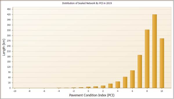
|
PCI |
Road Pavement Condition |
Length |
|
10 to 8 |
Very Good |
1038 km |
|
8 to 6 |
Good |
289 km |
|
6 to 4 |
Fair |
101 km |
|
4 to 2 |
Poor |
39 km |
|
2 to 0 |
Very Poor |
16 km |
|
<0 |
Failed |
9 km |
Based on the roads Pavement Condition Index (PCI) assessed in 2019 and current available surface treatment opportunities on the market, the following options can be considered for a best practice and cost effective road surface treatment renewal plan;
1. To review new asphalt resurface treatment products for roads that have pavement condition PCI of 6-8 (Good condition) and may have been scheduled for a spray seal renewal.
2. To develop a scaled program over five years that incorporates an increase in an asphalt resurfacing treatment program over spray sealed treatment for the whole road network.
Legal/Policy Basis
This report and its recommendations are consistent with the following legislative provisions:
Local Government Act 2009
Local Government Regulation 2012
RISK MANAGEMENT IMPLICATIONS
The Infrastructure and Environment Department has a departmental risk register that includes delivery of the capital program. The leadership team of the department continues to monitor our risk in relation to this and takes mitigation action where necessary.
HUMAN RIGHTS IMPLICATIONS
|
HUMAN RIGHTS IMPACTS |
|
RECEIVE AND NOTE REPORT |
|
Recommendation states that the report be received and the contents noted. The decision to receive and note the report does not limit human rights. Therefore, the decision is compatible with human rights.
|
Financial/RESOURCE IMPLICATIONS
In consideration of applying a more dominant asphalt resurfacing program over a sprayed seal option for road surface renewal, it does impact on capital budget requirements. On direct comparison, a sprayed seal renewal will cost approximately 40% less than an asphalt surface renewal, based on a per square metre basis. This can change dependant on other factors such as the site location, design, scale of the work and market pricing at the time.
COMMUNITY and OTHER CONSULTATION
Consultation has been undertaken with the Queensland Branch of the Australian Flexible Pavements Association (AfPA) in providing industry standard products. The have provided responses back from industry providers of road resurfacing treatments.
Conclusion
The Infrastructure and Environment Department (IED) is committed to exploring and providing the most cost-effective surface treatments for the road renewal program. This is based on risk, performance and available budget to develop a program that will maximise the benefits from road investment required.
Attachments and Confidential Background Papers
Brett McGrath
Manager, Asset Services
I concur with the recommendations contained in this report.
Sean Madigan
General Manager - Infrastructure and Environment
“Together, we proudly enhance the quality of life for our community”
|
Growth Infrastructure and Waste Committee Meeting Agenda |
15 September 2022 |
ITEM: 9
SUBJECT: Infrastructure and Environment Department Capital Delivery Report July 2022
AUTHOR: Manager, Capital Program Delivery
DATE: 24 August 2022
Executive Summary
This is a report concerning the performance of the capital delivery by the Infrastructure and Environment Department for the month of July 2022.
Recommendation/s
That the report be received and the contents noted.
RELATED PARTIES
There are no known conflicts of interest in relation to this report.
ifuture Theme
Vibrant and Growing
Purpose of Report/Background
Summary
A very pleasing result for the month of July to kick off the
new financial year, with expenditure tracking well over the Baseline Budget.
The result for the month of July is well ahead of the
original budget phasing, with actual expenditure being $6.25mil versus a budget
of $3.71mil, a positive variance of $2.54mil.
This was primarily as a result of the completion of
2021-2022 Carry Over works for key projects phased for July, in particular
within the resurfacing program. These carry-over projects were agreed to be
managed within the approved full-year capital budget.
The table below shows the baseline for the published budget for the 2022-2023 Financial Year.
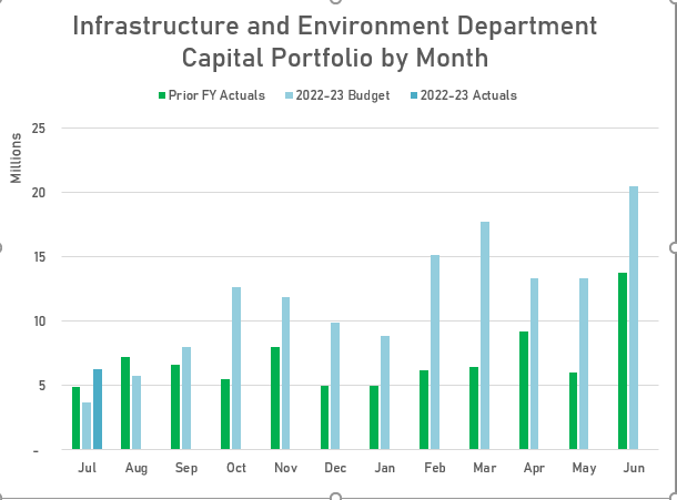
The July financial outcome of $6.25mil of actual
expenditure, versus the baseline budget of $3.71mil, was largely attributable
to the following areas:
· Resurfacing LR 21/22 Area’s 8 & 9 - $1.5mil (Carry Over)
· Kerb Rehab (Doyle, Cross & Trumper St’s) - $454k (Carry Over)
· Queens Park DR 22 - $88k (Carry Over)
· PTAIP Bus Stop Program - $80k (Carry Over)
· Waters Rd Gravel Rd Upgrade - $148k (Carry Over)
· Bundamba Creek Bridge BR 17 - $140k (Carry Over)
· Pettigrew St DR 22 - $146k (Carry Over)
· Pine Mountain Rd RS 21 - $75k
· Remote Control Mower 22 - $116k
There were also some key projects that were underspent
against their Baseline budget, due to delays with further wet weather
experienced in July (actual Rainfall 62.0mm vs average 24.3mm):
· Springfield Parkway UG - $287k
· Redbank Plains Youth Area - $342k
· Gravel Resheeting - $67k
· Queen and Albert St TL 17 - $152k
Strategic Transport projects at Springfield Parkway Upgrade
and early works for Redbank Plains Rd Stage 3 achieved a combined spend of
$982k, including the design spend against Springfield GBA RU and Springfield
Parkway Stage 2.
Key projects that progressed were the Pine Mountain Rd Road
Safety works with a spend of $195k vs budget of $120k. Kirton Street K&C
rehab with a spend of $200k vs budget of $273k and
Eleazar Drive pavement rehab project with a spend of $122k vs budget of $190k.
These projects were down on actual spend due to the wet weather in July.
The Gravel Re-sheeting Program was slightly down on spend in
July, due to continued saturated gravel roads from wet weather in early and
late July. Crews also continued with some flood repair works.
For the Minor Transport Programs there were also 12 x minor projects issued in relation to bike safe grates, bollards and fencing projects, with the intent for these to be designed and delivered this FY.
Waste expenditure was on budget, mainly due to minor
payments for the Southeast Queensland Regional Materials Recovery Facility
project that currently sits in concept design phase.
The Whitwood Rd rehabilitation works continued in July with final works now rescheduled for completion in mid-August due to further Extension of Time claims approved for wet weather experienced by the contractor.
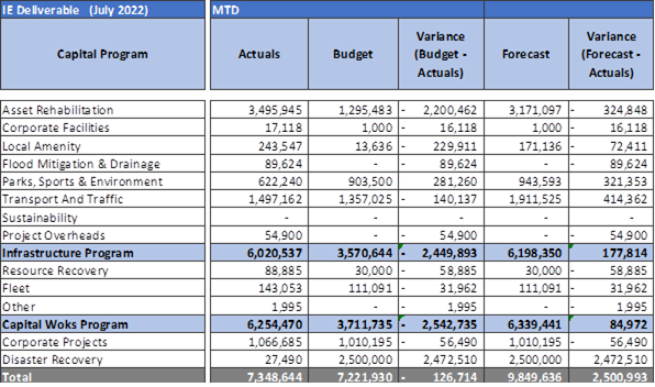
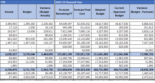
Monthly Program Variances Greater than $100k (Budget vs Actual)
Asset Rehabilitation was $2.20 mil over budget for
the month of July.
The over expenditure experienced is attributed to the
completion of carry over projects, predominantly rephased to July off the back
of wet weather experienced in the previous financial year.
The Bridge project at Bundamba Creek had an unbudgeted
combined spend of $140k, which was phased to be completed in August.
Drainage Rehabilitation projects at Pettigrew Street and
Hayne Street had a combined spend of $191k vs budget of $400K.
The Sports Facility Rehabilitation Program recorded an
underspend of $135k for the Bundamba Toddlers Pool resurfacing and Tivoli
Sports Club Lighting projects. These projects were completed as planned however
final payments had not been received at the end of the month.
The Road Resurfacing sub-program was ahead of budget by $1.5 mil as reported above, due to rephased works previously impacted with wet weather last Financial Year. Asphalt overlay works at Smiths Rd, Keidges Rd, Church St, Goodna and Old Logan Rd, Camira were carried over into the current Financial Year.
Parks, Sport & Environment was $281k under budget
for the month of July.
The result for the month was mainly due to the $352k
underspend on the Redbank Plains Youth Area and $17k on the Queens Park pathway
project due to wet weather delays. This was
offset slightly by the unbudgeted spend finishing the Jim Donald Clubhouse
design and above budget spend on the Windle Road Sports Field Upgrade design.
With regards to forward design, there was further design spend of $74k on Fernbrooke Sports Ground Lighting, Windle Rd Sports Field Upgrade and Richardson Park Playground.
Transport & Traffic was $140k over budget for the
month of July.
This was due primarily to the Pine Mountain Rd road safety
project and forward design effort for projects within the Minor Transport
programs. This offset the underspend of $305k on the Springfield Parkway
Upgrade, including design works for the Springfield Greenbank Arterial Upgrade.
Redbank Plains Stage 3 incurred under
budget expenditure of $38k against service relocation works, ahead of main
construction works commencing in early August.
PTAIP Bus Stop projects recorded $64k of expenditure against
design progress for 20 x sites scheduled for delivery this FY. The delivery of
these sites is still dependant on the final TMR approval for shared Grant
Funding.
There was unbudgeted Road Safety traffic spend of $24k
against Gibbs Street and Mitchell Street kerb ramp projects. There was also
minor spend of $12k against the Signs & Lines Program.
The Springfield Greenbank Arterial Rd Upgrade progressed further in design with $67k of expenditure against final design work. The Springfield Parkway Stage 3 design IFC drawings have been issued to TMR for review and service relocation designs are being finalised.
There was also unbudgeted expenditure recorded against forward design for Mt Juillerat Dr Upgrade, Ripley Rd Upgrade and School Road Upgrade.
Fleet was $32k over the budget
baseline for the month of July.
Fleet expenditure was on budget with spend of $28k vs budget
of $26k against Vehicle Replacement, with one vehicle being received for the
month. Further vehicle deliveries are scheduled to commence in September.
Truck replacements are budgeted from August to November and
again in May to June, based on advice from suppliers.
Waste truck purchases that were carried over to this FY,
have expenditure budgeted from August, with the major spend to occur in October
– November period.
There was also an unbudgeted spend of $116k for the purchase of a Remote Control Mower.
Summary
The current actuals to budget variance at end of July 2022
is $2.38 mil ahead of the baseline.
As shown in the top summary, the yearly cashflow has peaks in October and March, with the largest spend of $20.5 mil currently phased in June. This peak in June expenditure is driven by a forecast payment to the tri-Council Material Recycling Facility of $4mill and anticipated waste truck deliveries of $3mill.
Major Projects
Springfield Parkway & Springfield-Greenbank Arterial
Road Upgrade
Expenditure for the combined projects in July was $305k
under budget expectations ($1.23 mil budget vs $926k actual), this was due to
further wet weather in July which caused reduction in spend.
Significantly, the key milestone of sealing the new lanes from
Eden Station Drive to Opossum Creek Bridge was still achieved by the team.
Stage 1 – Good progress this month and highlight was asphalt being laid from Eden Station Rd to Opossum Creek Bridge.
The side-track for the Civil Works is working well and has allowed a large work area opposite Hymba Yumba to be opened.
Main activities for the Stage 1 Civil Works have been redundant service removal, subgrade preparation, unbound pavement completion, subsoil drains and gullies, sleeper retaining wall and bitumen sealing/asphalt works.
The Early Works Partial PC defects list is under action with the works to be completed with the Civil Works predominately complete and this will allow release of Securities and Retentions.
APA have completed gas pipe laying, with the live connections underway and programmed to be completed in August. Some night works are planned for a stormwater crossing at the roundabout and APA works at the school.
Other services relocations are complete and commissioned.
Stage 3 – TMR Abutment modification works are making good progress with completion programmed for August.
Potholing for Energex/ParknRide verge works has been undertaken with conduit works to start in August. Verge earthworks in front of the Lions Stadium have also commenced with the footpath closed to facilitate these works.
The geotechnical assessment of the batter opposite the Park n Ride has started with access across Mountain Creek.
We are negotiating with QR for the Eastern Carpark closure and facilitating BMD/SCG discussion on use of some of their land and access. Both are progressing well.
Some night works are planned for island/roundabout demolition, vegetation clearing and services crossings.
Urban Utility materials have been ordered to lock in pricing and avoid lead time delays.
The Stage 3 IFC drawings have been issued to TMR to review and services relocation designs are being finalised.
Redbank Plains Rd Stage 3
Expenditure for the project in July was $38k under budget
for the month.
The Principal Contractor remains on track to commence on site on 15th August 2022.
Delivery of Reinforced Concrete Pipes and culverts for the project have been fully received to a nearby stockpile. Dilapidation surveys and submission of project plans and traffic permits were undertaken in July for the Stage 1 project area.
Traffic permits are approved and ready for commencement of works.
NBN cable hauling and cut over will continue into September due to complexity issues, however these works are undertaken in isolation and have no effect on the main portion of the road upgrade construction works.
Resurfacing Program
Expenditure on the 2022-2023 resurfacing program was $13k under the budget baseline ($74k budget vs $61k actual). There was, however, $1.49 mil of carry over expenditure against Areas 8 & 9 for asphalt overlay works rephased from June, due to previous wet weather delays.
Carry over resurfacing works are scheduled for completion in Area 9 at the end of August and in Area 8 at the end of October.
For the scheduled 2022-2023 program, delivery packages for areas 1 – 7 are to be issued to the market by late August.
Design of the 2022-2023 program will continue through to the end of September, with delivery commencing in mid–October once the required ground temperatures for bitumen seal spraying are reached.
The current budgeted cashflow for resurfacing delivery, shows expenditure currently forecast from October through to April 2023.
The Final Estimate at Completion value at end of July was $14.09 mil Actual vs the Total Budget of $14.06 mil. The estimate at completion value will be subject to change once the program of works is awarded to the contractors and their submitted pricing is accepted.
Grant Funding
A further 14 x Bus Stop projects have been submitted to TMR for 50/50 Grant Funding approval. There are also 4 x Carry Over Bus Stop projects to be included for delivery this FY.
There are 3 x Blackspot projects funded for this FY:
· Ishmael Rd / Dale Rd Intersection - Install traffic islands and linemarking
· Smith St / Albert St Intersection – Upgrade existing traffic signals to include right turn lane on western & eastern approaches. Modify the signal phasing to provide split side streets.
· Roderick St / Waghorn St Intersection – Install traffic islands, linemarking and signage
PTAIP Bus Stop Program
There is a potential for 20 x Bus Stops to be completed this
FY, this includes 4 x Carry Over sites from last FY.
The carry Over sites were at Toongarra Rd, Riverview Rd, Old Ipswich Rd and Blackstone Rd, which were delayed due to watermain relocation negotiations and approvals.
Currently all new sites, with the exception of Wildey St bus stop, are in design phase and are scheduled for delivery in the 2nd half of the FY.
The majority of sites are currently scheduled with the Internal Delivery Team for construction with selected sites with service relocations, to be awarded to Contractors for delivery.
There are 4 x sites in the Willowbank area that are still on hold, as discussions continue with Translink around revised Bus Stop locations identified due to potential change of Bus Routes.
These sites now require road works, kerb & channel and drainage which was discussed with ICC in July, with regards to delivery in the 2022-2023 FY. Due to the complexity of the sites and extensive scope involved, the advice provided back to Translink was that design and delivery would need to be scheduled through to the end of the 2023-2024 FY.
Translink are proposing to fully fund these four sites, but wanted delivery completed by June 2023. Discussions will continue with Translink around the possible delivery of these sites by ICC, if the funded timeframe can be extended.
Expenditure on the Bus Stop program was $64k for the month of July, against forward design effort.
Once advice / approval of the Grant Funding has been received from TMR, the full forecast can be recognised and reported.
Grant Projects
Scheduled for delivery this FY (includes Multi-year Funding)
NOTE: Below table includes reporting on capital construction projects only – it does not include Design Only or OPEX projects
|
Name |
Suburb |
Estimate |
Approved Funding |
Completion Date (Completed) |
|
LRCIP Round 3 (Local Roads & Community Infrastructure Program) |
|
|
|
|
|
Alice St KC 18 |
Bundamba |
$0 |
$955,000 |
3/03/2023 |
|
Charlotte St |
Basin Pocket |
$1,450,000 |
$950,000 |
18/11/2022 |
|
Settler Way LR 19 |
Karalee |
$930,000 |
$650,000 |
17/10/2022 |
|
Nolan St LR 20 |
Raceview |
$1,010,000 |
$200,000 |
18/11/2022 |
|
Iron Bark Park CH 22 |
South Ripley |
$1,500,000 |
$1,500,000 |
28/08/2023 |
|
URCSP (Unite and Recover Community Stimulus Package) |
|
|
|
|
|
Adelong Avenue LR 24 |
Thagoona |
$40,000 |
$0 |
26/03/24 |
|
PTAIP (Passenger Transport Accessible Infrastructure Program) |
|
|
|
|
|
PTAIP BU 22 – Bus Stops x 16 + 4 Carry Over sites |
|
$1,069,000 |
$00 |
|
|
Toongarra Rd – ID 312513 (CO) |
Leichhardt |
$89,560 |
|
12/08/2022 |
|
Riverview Rd – ID 313072 (CO) |
Riverview |
$66,129 |
|
17/08/2022 |
|
Old Ipswich Rd – ID 313063 (CO) |
Riverview |
$54,320 |
|
16/11/2022 |
|
Blackstone Rd – ID 312136 (CO) |
Eastern Heights |
$52,618 |
|
4/11/2022 |
|
Wildey St – ID 310837 |
Raceview |
|
|
1/08/2022 |
|
Alawoona St – ID 317826 |
Redbank Plains |
|
|
12/06/2023 |
|
Brisbane Terrace – ID 312218 |
Leichhardt |
|
|
8/03/2023 |
|
Layard St – ID 317733 |
Goodna |
|
|
1/02/2023 |
|
Hill St – ID 311117 |
North Ipswich |
|
|
20/06/2023 |
|
Reif St – ID 310536 |
Flinders View |
|
|
26/05/2023 |
|
Ripley Rd – ID 310540 |
Ripley |
|
|
3/03/2023 |
|
Springfield Lake Bvd – ID 317838 |
Springfield Lakes |
|
|
9/02/2023 |
|
Tunstall Place – ID 317803 |
Brassall |
|
|
3/03/2023 |
|
Old Logan Rd – ID 317733 |
Camira |
|
|
1/02/2023 |
|
Old Logan Rd – ID 317734 |
Camira |
|
|
23/01/2023 |
|
Springfield Lakes Bvd – ID 317841 |
Springfield Lakes |
|
|
16/02/2023 |
|
Bremer School – ID 310576 |
Ipswich |
|
|
1/06/2023 |
|
Warwick Rd – ID 310575 |
Ipswich |
|
|
28/02/2023 |
|
Sutton Park – ID 313972 |
Brassall |
|
|
28/02/2023 |
|
Collins St – ID 317804 |
Brassall |
|
|
3/03/2023 |
|
CNLGGP (Cycle Network Local Government Grants Program) |
|
|
|
|
|
Eastern Ipswich BW Stage 2 |
Ipswich |
$225,000 |
TBC |
|
|
Thorn St BW 16 |
Ipswich |
|
$125,000 |
TBC |
|
Deebing Creek BW Stage 2 |
Ipswich |
|
$75,000 |
TBC |
|
Blackspot |
|
|
|
|
|
Ishmael Rd & Dale Rd TI 22 |
Camira |
|
$97,000 |
TBC |
|
Smith St Albert St TL 22 |
Goodna |
|
$413,000 |
TBC |
|
Roderick St Waghorn St TI 22 |
Ipswich |
|
$104,000 |
TBC |
|
TIDS (Transport Infrastructure Development Scheme) |
|
|
|
|
|
Redbank Plains Stage 3 |
Redbank Plains / Bellbird Park |
14,966,000 |
705,446 |
29/06/23 |
|
R2R (Roads to Recovery) |
||||
|
Springfield Greenbank Arterial |
Springfield / Springfield Ctl / Springfield Lakes |
21,014,554 |
2,327,860 |
23/06/23 |
|
SEQCSP (Southeast Queensland Community Stimulus Program) |
|
|
|
|
|
Rosewood RRC Major Upgrade |
Rosewood |
$4,500,000 |
$4,500,000 |
30/03/2024 |
|
Riverview RRC Upgrade Stage 1 |
Riverview |
$2,170,000 |
$2,170,000 |
30/06/2023 |
Multi-year Funded Grant Projects
· Rosewood RRC Major Upgrade
· Riverview RRC Upgrade Stage 1
Master Schedule Delivery Milestones for July
|
Milestone |
July Baseline |
July Actual |
Actuals Year to date |
|
Practical Completion |
5 |
5 |
5 |
As at end of July, project completion status shows 5 projects have reached practical completion from a total of 106 projects that are scheduled for delivery this FY.
Master Schedule Baseline Deliverables for 2022-2023 FY
|
Baseline Deliverables |
Count of Projects |
|
Design |
|
|
Concept Design |
67 |
|
Detailed Design |
114 |
|
Construction |
|
|
(IFC yet to Complete) |
67 |
|
(IFC completed) |
6 |
|
Multiyear Construction |
10 |
|
Programs |
53 |
The progress of projects to have design completed and issued for delivery this FY are tracking well, with 67 project designs remaining scheduled to be IFC. This number however also includes the 15 x Bus Stop designs drawn down from the PTAIP parent project. The overall projects to complete tally of 106, only contains the one PTAIP parent project from the original Capital Budget.
The data shown above for Concept Design and Detailed Design includes forward design efforts for project delivery in the 2023-2024 FY.
Legal/Policy Basis
This report and its recommendations are consistent with the following legislative provisions:
Local Government Act 2009
RISK MANAGEMENT IMPLICATIONS
The Infrastructure and Environment Department has a departmental risk register that includes delivery of the capital program. The leadership team of the department continues to monitor our risk in relation to this and takes mitigation action where necessary.
HUMAN RIGHTS IMPLICATIONS
|
HUMAN RIGHTS IMPACTS |
|
RECEIVE AND NOTE REPORT |
|
The recommendation states that the report be received and the contents noted. The decision to receive and note the report does not limit human rights. Therefore, the decision is compatible with human rights.
|
Financial/RESOURCE IMPLICATIONS
No financial / resource implications.
COMMUNITY and OTHER CONSULTATION
No community consultation was required in relation to this report.
The Stakeholder Management Branch of the Infrastructure and Environment Department engages extensively with the community impacted by our works to ensure that they are informed in advance of works, communicated with during works and ensure that any issues that arise are managed effectively.
Conclusion
The Infrastructure and Environment Department is committed to delivering high quality infrastructure for the community.
Attachments and Confidential Background Papers
|
1. |
Capital Delivery Report July 2022 ⇩ |
|
2. |
Asset Rehabilitation Progress Report ⇩ |
Graeme Martin
Manager, Capital Program Delivery
I concur with the recommendations contained in this report.
Sean Madigan
General Manager - Infrastructure and Environment
“Together, we proudly enhance the quality of life for our community”
|
Growth Infrastructure and Waste Committee Meeting Agenda |
15 September 2022 |
ITEM: 10
SUBJECT: Planning and Environment Court Action Status Report
AUTHOR: Manager, Development Planning
DATE: 26 August 2022
Executive Summary
This is a report concerning a status update with respect to current court actions associated with development planning applications.
Recommendation
That the report be received and the contents noted.
RELATED PARTIES
The related parties, being the appellants associated with any court actions, are detailed in the attachment to this report.
IFuture Theme
Vibrant and Growing
Safe, Inclusive and Creative
Natural and Sustainable
A Trusted and Leading Organisation
DISCUSSION
Whilst this report outlines a specific list of development application related court actions, from time to time, Council will be engaged in prosecutions relating to development offences and other matters. Owing to the nature of these prosecutions, these matters are not generally listed in the attached court action report. However substantial matters will be presented to the Growth, Infrastructure and Waste Committee using this report from time to time. It is worth noting that the Judicial Review of the Ministerial Call In of the Wanless application is one such matter on this list. This is a matter before the Supreme Court.
Legal/Policy Basis
This report and its recommendations are consistent with the following legislative provisions:
Local Government Act 2009
Planning Act 2016
Planning and Environment Court Act 2016
RISK MANAGEMENT IMPLICATIONS
There are no risk management implications associated with this report.
HUMAN RIGHTS IMPLICATIONS
|
HUMAN RIGHTS IMPACTS |
|
RECEIVE AND NOTE REPORT |
|
The recommendation states that the report be received and the contents noted. The decision to receive and note the report does not limit human rights. Therefore, the decision is compatible with human rights.
|
Financial/RESOURCE IMPLICATIONS
N/A
COMMUNITY and OTHER CONSULTATION
The contents of this report did not require any community consultation.
Conclusion
The Planning and Regulatory Services Department are currently involved with several Planning and Environment Court and Supreme Court matters. Attachment 1 to this report provides a current status with respect to these matters.
Attachments and Confidential Background Papers
|
1. |
Planning and Environment Court Action Status Report ⇩ |
Anthony Bowles
Manager, Development Planning
I concur with the recommendations contained in this report.
Peter Tabulo
General Manager Planning and Regulatory Services
“Together, we proudly enhance the quality of life for our community”
|
Growth Infrastructure and Waste Committee Meeting Agenda |
15 September 2022 |
ITEM: 11
SUBJECT: Exercise Of Delegation Report
AUTHOR: Manager, Development Planning
DATE: 26 August 2022
This is a report concerning applications that have been determined by delegated authority for the period 26 July 2022 to 26 August 2022.
That the report be received and the contents noted.
There are no related parties associated with the recommendation as the development applications have already been determined.
A Trusted and Leading Organisation
The following delegations (and associated sub-delegations) contain a requirement for the noting of applications determined by delegated authority:
· Approval of Plans for Springfield
· Determination of Development Applications, Precinct Plans, Area Development Plans and Related Matters
· Exercise the Powers of Council under the Economic Development Act 2012
· Implementation of the Planning and Development Program
· Exercise the Powers of Council under the Planning Act 2016
This report and its recommendations are consistent with the following legislative provisions:
Local Government Act 2009
Planning Act 2016
Economic Development Act 2012
There are no risk management implications associated with this report.
|
HUMAN RIGHTS IMPACTS |
|
RECEIVE AND NOTE REPORT |
|
The recommendation states that the report be received and the contents noted. The decision to receive and note the report does not limit human rights. Therefore, the decision is compatible with human rights. |
There are no resourcing or budget implications associated with this report.
The contents of this report did not require any community consultation. In the event that the development applications listed in this report triggered ‘impact assessment’ pursuant to the Ipswich Planning Scheme, public notification was undertaken as part of the development application process in accordance with any legislative requirements and matters raised in any submissions and were addressed in the respective development assessment reports.
The Planning and Regulatory
Services Department is responsible for the assessment and determination of
development applications. Attachment 1 to this report provides a list of
development applications that were determined by delegated authority for the
period
26 July 2022 to 26 August 2022.
|
1. |
Exercise of delegation report ⇩ |
Anthony Bowles
Manager, Development Planning
I concur with the recommendations contained in this report.
Peter Tabulo
General Manager Planning and Regulatory Services
“Together, we proudly enhance the quality of life for our community”